- Old Ottawa South
-
Ottawa South — Neighbourhood — Location in Ottawa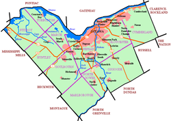
 Ottawa South
Coordinates: 45°23′30″N 75°41′00″W / 45.39167°N 75.6833333°W Country Canada Province Ontario City Ottawa Established 1814 Incorporated 1905 (Police Village of Rideauville) Annexation 1907 (City of Ottawa) Government – Mayor Jim Watson – MPs Paul Dewar – MPPs Yasir Naqvi – Councillors David Chernushenko Area – Total 2.05 km2 (0.8 sq mi) Elevation 65 m (213 ft) Population (2006) – Total 8,168 – Density 3,984.4/km2 (10,319.5/sq mi) Canada 2006 Census Time zone Eastern (EST) (UTC−5) – Summer (DST) EDT (UTC−4) Old Ottawa South is an older urban neighbourhood in Ottawa, Canada. As of the Canada 2006 Census, 8,168 people lived in Old Ottawa South, a relatively small and compact neighbourhood, located between the Rideau Canal (to the north) and the Rideau River (to the south). The eastern boundary is defined by Riverdale Avenue and Main Street. Bronson Avenue forms the western border of the residential neighbourhood. Carleton University is on the other (western) side of Bronson but the campus can be considered to be geographically within Old Ottawa South as the campus is also nestled between the river and the canal.
 The Royal College of Physicians and Surgeons of Canada is headquartered in Old Ottawa South in this former monastery (built c. 1914).
Today, Ottawa South is a primarily upper middle class area. Proximity to the university has meant that the neighbourhood has been a haven for professors and students, although rising housing prices are driving out the latter. It is also one of Ottawa's more liberally progressive neighbourhoods and has been a stronghold for the New Democratic Party.
Many neighbourhood businesses line Bank Street, including several pubs, the Mayfair Theatre, the Ottawa Folklore Centre (which primarily sells stringed instruments), and some Lebanese stores towards the Southern end. This section of Bank Street is also well known for its antique stores. As part of a 2004 Bank Street redesign, inlaid metal maple leaves were added to the sidewalks inscribed with the names of Canadian folk musicians. Other new features included the removal of over-head powerlines, "traffic calming" measures, and the addition of more brick to the sidewalks.
The area was originally settled around 1814 by American and British settlers. In those years, even after the construction of the canal the area was fairly sparsely populated. The larger community south of the Rideau River around the Billings estate exerted more influence over the fledgling community than the city of Ottawa did in those days.
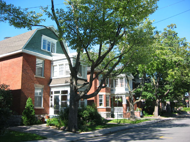
 Typical architecture dating from the early 20th century
 Ossington Ave
 The Bank Street Bridge and canal in winter. The canal marks the northern boundary of Old Ottawa South.
Shortly after Confederation in 1867 a bridge was built over the canal increasing access from the larger city to the north. The area was tentatively called Rideauville at the time. After the turn of the century the area grew very rapidly. Rideauville was incorporated as a police village in 1905 and was annexed to Ottawa in 1907. The streetcar tracks were extended to the area around 1910, again encouraging rapid growth. The old streetcar ran along a route roughly similar to today's bus route #7, turning around in what is now Brewer Park. Hopewell school was built around this time.
The architectural style is mostly "Craftsman", with many houses in the American Foursquare style popular in the 1920s and 1930s. Many of these houses have been upgraded and added to over the years, contributing to the area's eclectic style.
 Most streets are tree lined
Since the 1920s, the streetcars have been replaced by buses, stores have changed, and Carleton University has been constructed on the site of an old garbage dump.[citation needed] Many of the streetscapes and much of the housing has been preserved however.
Notable buildings include Hopewell Public School, Southminster Church, St. Margaret Mary Church, Trinity Church, the Mayfair Theatre, the former Precious Blood Convent (now The Royal College of Physicians & Surgeons of Canada), and the Old Firehall (currently a community centre).
Around 300 residences and institutional buildings are included on Ottawa's heritage reference list (an inventory of sites & structures potentially considered for legal protection as cultural heritage resources) from the area.
Old Ottawa South, used to be known simply as "Ottawa South". The "old" designation came into use in the 1990s to distinguish the community from newer suburban developments in the south of Ottawa. "Old Ottawa South" is actually quite central and close to downtown by modern (post World War II) standards. The term "Ottawa South" is still in use in some contexts. For example, the community newspaper is The OSCAR, which stands for Ottawa South Community Association Review. Similarly, Old Ottawa South is not to be confused with the parliamentary constituency of Ottawa South. Old Ottawa South is currently located in the federal and provincial constituencies of Ottawa Centre, although Old Ottawa South was within the Ottawa South provincial riding until the 1990s.
In the fall of 2007 leading up to the 100th anniversary of the annexation of Ottawa South to the City of Ottawa on December 16, 2007, a group of local residents founded the Ottawa South History Project (OSHP) to research, document and present facts and anecdotes about the history of the community. The OSHP is an amateur run historical society which regular publishes in The OSCAR and maintains a website. The group is also active in supporting the heritage designation of the Mayfair Theatre, and is a partner in the Friends of the Mayfair Theatre.
See also

The Glebe Old Ottawa East Carleton University 
Riverview  Old Ottawa South

Confederation Heights Billings Bridge Alta Vista External links
Coordinates: 45°23′30″N 75°41′00″W / 45.39167°N 75.6833333°W
Categories:- Neighbourhoods in Ottawa
- Former municipalities now in Ottawa


Wikimedia Foundation. 2010.