- New York State Route 25C
-
NYS Route 25C
Route information Auxiliary route of NY 25 Maintained by NYSDOT Length: 4.29 mi[4] (6.90 km) Existed: mid-1930s[1][2] – January 1, 1970[3] Major junctions West end:  NY 25 in Queens Village
 Grand Central Parkway in Queens Village
 Cross Island Parkway in Queens Village
East end:  NY 25B in New Hyde Park
Location Counties: Queens, Nassau Highway system Numbered highways in New York
Interstate • U.S. • N.Y. (former) • Reference • County← NY 25BNY 25D  →
→New York State Route 25C (NY 25C) was an east–west state highway on Long Island in New York in the United States. The route began in Queens at an intersection with NY 25 and paralleled NY 25B for just over 4 miles (6 km) before ending at a junction with NY 25B in western Nassau County. NY 25C was assigned in the 1930s and removed in 1970. Part of the route's former routing is still state-maintained as New York State Route 900F, an unsigned reference route.
Contents
Route description
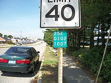 Reference marker along former NY 25C in North New Hyde Park
NY 25C began at the intersection of Springfield Boulevard and Union Turnpike in the Queens neighborhood of Queens Village. Here, the route connected to NY 25, which entered from the west on Union Turnpike and left to the south on Springfield Boulevard. In Queens, as well as near Lake Success in Nassau County, NY 25C utilized Union Turnpike, a road often recognized more by its name than by its designation.[5] At the east end of the Union Turnpike at Marcus Avenue, it continued southeastward along Marcus Avenue to Hillside Manor, where the route ended at a junction with NY 25B.[6]
History
The NY 25C designation was assigned in the mid-1930s to the portion of Marcus Avenue between Hillside Avenue (NY 25B) and the Northern State Parkway.[1][2] In the 1940s, the northernmost portion of the route was realigned to follow Union Turnpike west into Queens, where it ended at Springfield Boulevard (then NY 25).[7][8] NY 25C remained unchanged[5] until January 1, 1970, when the designation was removed.[3] The portion of the route in Nassau County between the New York City line and Marcus Avenue is now NY 900F, an unsigned reference route.[9] Reference markers along this portion of highway read "25C", reflecting the former designation of the route.[10]
Major intersections
County Location Mile[4] Destinations Notes Queens Queens Village 0.00 NY 250.28 Grand Central ParkwayExits 22–23 (GCP) 1.13 Cross Island ParkwayExit 28B (Cross Island Parkway) Nassau New Hyde Park 4.29 NY 25B1.000 mi = 1.609 km; 1.000 km = 0.621 mi References
- ^ a b Texas Oil Company (1933). Texaco Road Map – New York (Map). Cartography by Rand McNally and Company.
- ^ a b Shell Oil Company (1936). Road Map – Metropolitan New York and Long Island (Map). Cartography by H.M. Gousha Company.
- ^ a b State of New York Department of Transportation (January 1, 1970) (PDF). Official Description of Touring Routes in New York State. http://www.greaternyroads.info/pdfs/state70.pdf. Retrieved December 3, 2009.
- ^ a b Yahoo! Inc. Yahoo! Maps – overview map of former NY 25C (Map). Cartography by NAVTEQ. http://maps.yahoo.com/#mvt=h&lat=40.74537&lon=-73.709865&zoom=15&q1=40.735717%2C-73.746422&q2=40.736806%2C-73.741293&q3=40.740838%2C-73.726316&q4=40.752608%2C-73.701382&q5=40.751535%2C-73.673294. Retrieved December 30, 2010.
- ^ a b State of New York Department of Commerce (1969). New York State Highways (Map). Cartography by Rand McNally and Company.
- ^ Mobil (1965). New York (Map). Cartography by Rand McNally and Company.
- ^ Gulf Oil Company (1940). New York Info-Map (Map). Cartography by Rand McNally and Company.
- ^ State of New York Department of Public Works. Official Highway Map of New York State (Map). Cartography by General Drafting (1947–48 ed.).
- ^ "2008 Traffic Data Report for New York State" (PDF). New York State Department of Transportation. June 16, 2009. p. 327. https://www.nysdot.gov/divisions/engineering/technical-services/hds-respository/NYSDOT_Traffic_Data_Report_2008.pdf. Retrieved December 3, 2009.
- ^ Perry, N.W. (2004). "Reference Routes – Regions 10 and 11". Empire State Roads. http://www.empirestateroads.com/sr/refroute10.html. Retrieved December 31, 2010.
External links
Major streets of Queens Astoria Boulevard · Atlantic Avenue · Beach Channel Drive · Conduit Boulevard · Cross Bay Boulevard ·
Ditmars Boulevard · Farmers Boulevard · Flushing Avenue · Francis Lewis Boulevard · Grand Avenue · Hempstead Avenue · Hillside Avenue · Jamaica Avenue · Kissena Boulelvard · Linden Boulevard · Main Street · Merrick Boulevard · Metropolitan Avenue · Myrtle Avenue · Northern Boulevard · Queens Boulevard · Rockaway Boulevard · Rockaway Beach Boulevard · Roosevelt Avenue · Springfield Boulevard · Steinway Street · Union Turnpike · Woodhaven BoulevardCategories:- Former state highways in New York
- Streets in Queens
- Transportation in Nassau County, New York


Wikimedia Foundation. 2010.