- Onondaga Lake
-
Onondaga Lake 
Location Onondaga County, New York, USA Coordinates 43°5′20″N 76°12′30″W / 43.08889°N 76.20833°WCoordinates: 43°5′20″N 76°12′30″W / 43.08889°N 76.20833°W Primary inflows Ninemile Creek, Onondaga Creek Primary outflows Seneca River Basin countries United States Max. length 4.6 mi (6.9 km) Max. width 1 mi (1.5 km) Surface area 4.6 sq mi (12 km2) Max. depth 63 ft (19 m) Surface elevation 370 feet (110 m) Onondaga Lake is a lake in Central New York located northwest of Syracuse, New York. The southeastern end of the lake and the southwestern shore abut industrial areas and expressways; the northeastern shore and northwestern end border a series of parks and museums.[1] Although it is near the Finger Lakes region, it is not traditionally counted as one of the Finger Lakes. Onondaga Lake is a dimictic lake,[2] meaning that the lake water completely mixes from top to bottom twice a year. The lake is 4.6 miles long and 1 mile wide. The maximum depth of the lake is 63 feet with an average depth of 35 feet.[3] Onondaga Lake has a surface area of 12 square kilometers.[2] Its drainage basin has a surface area of 642 square kilometers, encompassing Syracuse, Onondaga County except the eastern and northern edges, the southeastern corner of Cayuga County and the Onondaga Nation Territory,[4] and supports approximately 450,000 people.[5]
Onondaga Lake has two natural tributaries that contribute approximately 70% of the total water flow to the lake. These tributaries are: Ninemile Creek and Onondaga Creek. The Metropolitan Syracuse Wastewater Treatment Plant (METRO) contributes 20% of the annual flow.[3][6] No other lake in the United States receives as much of its inflow as treated wastewater.[7] The other tributaries, which include Ley Creek, Bloody Brook, Harbor Brook, Sawmill Creek, Tributary 5A, and East Flume, contribute the remaining 10% of water flow into the lake.[3][6] The tributaries flush the lake out about four times a year.[5] Onondaga Lake is flushed much more rapidly than most other lakes.[6] The lake flows to the northwest[8] and discharges into Seneca River which combines with the Oneida River to form the Oswego River, and ultimately ends up in Lake Ontario.[2]
During the late 19th century many resorts were built along Onondaga Lake's shoreline. However, after the Industrial Revolution domestic and industrial waste, due to development and urbanization, led to the severe degradation of the lake. Unsafe levels of pollution led to the banning of ice harvesting in 1901. In 1940 swimming was banned and in 1970 fishing was banned due to mercury contamination.[2][5] Mercury pollution is still an existing problem for the lake today.[3] Despite the passage of the Clean Water Act in 1973 and the closing of the major industrial polluter in 1986, Onondaga Lake is still one of the most polluted lakes in the United States. Several initiatives, including a 15-year multi-stage program currently under way, have been recently undertaken to clean up the lake.
Contents
History
Pre-European Settlement
See also: Onondaga people and IroquoisOnondaga Lake is traditionally regarded as the birthplace of the Haudenosaunee, also known as the Iroquois, Confederacy. The Great Peacemaker brought together the Seneca, Cayuga, Onondaga, Oneida, and Mohawk Nations on the shores of the lake. These warring nations accepted the Great Peacemaker's message of peace, laid down their weapons, and formed the Haudenosaunee Confederacy. Since then, the lake has become a sacred place.[9]
The Onondaga Nation's "Vision for a Clean Onondaga Lake" states that the waters, plants, fish, shore birds, and animals of the lake are an intrinsic part of the people's existence. Onondagans view the restoration of the lake as a personal responsibility and are working towards efforts to make sure that the lake is clean enough to drink water, eat the fish, and swim in.[10]
Early European Settlement
 Onondaga Lake motor boat ride by moonlight about 1907
European knowledge of the salt springs occurred in 1654 when the Onondagas revealed their presence to French explorers.[11] Jesuit missionaries visiting the Syracuse region at the same time period were the first to report on salty brine springs around the southern end of "Salt Lake," known today as Onondaga Lake. The brine springs were reported to have extended around much of the lake for a distance of nearly 9 miles. They extended from the towns of Salina through Geddes and from Liverpool to near the mouth of Ninemile Creek.[12] European settlers, mostly trappers and traders, followed the Jesuit missionaries and French explorers into the Syracuse area during the 17th and 18th centuries.[11]
Salt production began in the late 18th century. In 1788, the Treaty of Fort Stanwix transferred the lands around the lake from the Onondaga Nation to local salt producers on the condition that the salt would be produced for the common use of everyone.[12] By 1822, due to serious threat of malaria, the lake's water level was lowered after its outlet to the Seneca River was dredged and the low lying swampy area, located in what is now the northern end of downtown Syracuse, was drained.[11] The completion of the Erie Canal in the early 1880s and the commercial production of salt brought an increase in settlement of the area. The lake's western shore became increasingly industrialized.[7][13]
Onondaga Lake also became a popular resort area.[14] Its shoreline was dotted with hotels, restaurants, and amusement parks.[11] The area was so popular that people traveled from as far as New York City to visit the lake. Fish from the lake were served in restaurants across the state.[15] One of the more popular resort areas was named the Iron Pier which was located near the present site of the Carousel Center at the south end of the lake. The pier featured a variety of recreational activities in a resort pavilion. In addition, steamboat services departed from the pier and transported tourists to other resorts around the lake.[15] The lake initially supported a cold-water fishery, but due to industrialization the cold-water fishery was lost by 1890.[7]
Industry
See also: Salt industry in Syracuse, New YorkThe systematic production of salt began in 1797, when the New York State Legislature designated a one-mile-wide strip of land around the northern half of the lake as the Onondaga Salt Springs Reservation. Between 1797 and 1917, the Onondaga Salt Springs Reservation produced more than 11.5 million tons of finished salt].[12]
Salt brine and limestone were the key raw materials for the production of soda ash. The abundance of salt brine and limestone in Onondaga Lake's watershed area attributed greatly for the industrialization along the lake's shoreline.[11] Beginning in 1838, New York State authorized the drilling of deep wells at several locations around the lake. The wells intended to locate the source of the brine, however, no source was located.
 Salt Wells at Syracuse, New York c. 1900
The Solvay Process company, incorporated in 1881,[16] began drilling deep test holes in the area south of Syracuse in 1883. The company's main product was soda ash whch was used to make glass, chemicals, detergent, and paper. Eventually Solvay encountered halite deposits at a depth of 1,216 feet below land surface in the southern end of Tully Valley. From 1890 to 1986 more than 120 wells were drilled into four halite beds on the east and west flanks of the valley].[12] Soda ash production began in 1884. The company was producing about 20 tons of soda ash per day and most of the waste material was dumped directly into Onondaga Lake.[16] Eventually wastebeds were built along the southwest perimeter of the lake to contain the by-products of soda ash production.[8] In 1907, the New York State Attorney General threatened the Solvay Process Company with legal action over the direct discharge of Solvay waste material into the lake.[16]
In 1920, the Solvay Process Company merged with four other chemical companies and formed Allied Chemical and Dye Corporation. Allied Chemical and Dye Corporation began the production of chlorine by mercury cell in 1950. Mercury was dumped directly into Onondaga Lake. Allied Chemical and Dye Corporation became Allied Chemical Corporation in 1958. The continual practice of dumping mercury into the lake led to a fishing ban in 1970 due to mercury contamination of the fish. Allied Chemical was sued by the US Attorney General in order to halt the dumping of mercury into the lake. It is estimated that Allied Chemical was dumping approximately 25 pounds of mercury into Onondaga Lake per day. In 1981 Allied Chemical Corporation become Allied Corporation and again changed its name to Allied-Signal, Inc. in 1985 when it merged with the Signal companies. The company announced that it will close its operations in Syracuse and in 1986 began dismantling its facility.[16]
In 1989, New York State filed a lawsuit against Allied-Signal, Inc. for its responsibility in the contamination of Onondaga Lake. New York State and Allied-Signnal, Inc. signed an interim Consent Decree detailing the elements of a Remedial Investigation and Feasibility Study of the lake. In compliance with the Consent Decree, the study was conducted by Allied-Signal, Inc. which became Honeywell, Inc. in 1999.[16]
Non-salt-producing companies also established themselves along Onondaga Creek valley from the mid-19th century to the early 20th century. Many of these companies drilled wells into the underlying sand to obtain water for cooling purposes for the protection of dairy products and beer, storage of perishable goods, and temperature regulation in office and storage buildings. Once used, the water was disposed of in nearby streams that drained to Onondaga Lake. This practice increased the salinity of the surface-water system].[12]
Pollution
Sewage Pollution
One major source of pollution for Onondaga Lake is sewage wastewater. For years, Syracuse dumped human waste into the lake with little or no treatment.[17][18] Before European settlement, the lake was oligo-mesothropic, meaning that it contained low levels of aquatic plant blooms.[7] However, the high levels of ammonia and phosphorus due to the sewage wastewater have directly affected the lake and have led to excessive algae growth in the lake.[18] The algae use large quantities of oxygen causing eutrophic and low-oxygen conditions.[19] The low oxygen levels lead to the choking out of fish and plants, especially in the deeper areas of the lake.[18]
Another issue contributing to sewage pollution is combined sewer overflow (CSO). In some areas of Syracuse there are sewers that carry both sanitary sewage and stormwater. During dry weather these sewers carry all the sanitary sewage to Metro for treatment, however, during times of heavy rain or melting snow the amount of water is greater than the capacity of the sewers and they overflow and discharge a combination of runoff and sanitary sewage into Onondaga Creek and Harbor Brook.[20] Through these tributaries the CSO eventually reaches Onondaga Lake. CSO has been generating concerns about bacteria.[19] In the 1960s, Syracuse had ninety points where CSO could reach Onondaga Creek, Harbor Brook, or Ley Creek.[11]
Chemical Pollution

Honeywell, Inc. and its predecessors have contributed greatly to the chemical pollution of Onondaga Lake. The surface water has been found to be contaminated with mercury whereas the sediments are contaminated with polychlorinated biphenyls (PCB's), pesticides, creosotes, heavy metals (lead, cobalt, and mercury), polycyclic aromatic hydrocarbons (PAH's), chlorinated benzenes, and BTEX compounds (benzene, ethylbenzene, toluene, xylene).[8][17][19][21] In Onondaga Lake the chlorinated benzenes are located in the southewest corner of the lake in the form of a dense oily liquid that has settled into the sediments.[21] These chemicals were intentionally dumped into the lake or unintentionally seeped in from upland toxic waste sites or from the Solvay wastebeds located at the southwest end of Onondaga Lake. The wastebeds continue to leak toxins into the lake today. Approximately 6 million pounds of salty wastes made up of chloride, sodium, and calcium were dumped daily into the lake before it closed in 1986.[17]
A large chemical pollution issue has been the mercury contamination of the lake. Between 1946 and 1970, 165,000 pounds of mercury was dumped into Onondaga Lake by Allied Chemical and Dye Corporation.[17] In 2002, the findings from the remedial investigation conducted by Honeywell, Inc. with the supervision of the New York State Department of Environmental Conservation (NYSDEC) reported that mercury contamination is found throughout the lake with the most elevated concentrations found in the sediments of the Ninemile Creek delta and in the sediments of the southwestern portion of the lake.[22] A fishing ban was imposed in 1970.[16] In 1999, the New York State Department of Health (NYSDOH) lifted the advisory on eating bass, white perch, and catfish from Onondaga Lake. The advisory on eating no walleye remained in effect and women of childbearing age, infants, and children under the age of 15 were advised not to eat any of the fish from the lake.[23] In 2007, the NYSDOH updated its advisory prohibiting the consumption of largemouth and smallmouth bass over 15-inches-long. No walleye, carp, channel catfish, and white perch of any size should be consumed. The Department of Health advises up to four meals per month of brown bullhead and pumpkinseed, and up to one meal per month of any species not listed.[24]
Other Issues
Mudboils
Approximately 18 miles south of Syracuse, the Tully Valley has unique hydrogeological features called mudboils. These mudboils are the cause of the excessive sedimentation of Onondaga Lake. The sediment from the mudboils enters Onondaga Creek which flows north into the lake. Sediment loading is a problem because it degrades water quality, decreases water clarity, and reduces habitat for aquatic insects, fish spawning, and plants[17][25]
Legal Action & Cleanup
Sewage Pollution Cleanup
The first steps taken to control sewage pollution occurred in 1907 with the creation of the Syracuse Interceptor Sewage Board. It served to address sewage-related problems in Onondaga Creek and Harbor Brook. In 1960, Onondaga County established a sewer district and built the Metropolitan Sewage Treatment Plant, Metro, on the south shore of the lake.[17]
In 1988, Atlantic States Legal Foundation (ASLF), a Syracuse-based organization providing legal and technical assistance to citizens and organizations dealing with environmental problems, filed a lawsuit against Onondaga County alleging that Metro and the combined sewer overflow (CSO) discharges were violating federal water pollution standards established under the Clean Water Act of 1972. The state of New York joined as a plaintiff with allegations that Onondaga County had also violated the New York State Environmental Conservation Law.[26]
In 1990, the U.S. Congress created the Onondaga Lake Management Conference (Public Law 101-596, section 401) and ordered it to develop a comprehensive revitalization, conservation, and management plan for Onondaga Lake that recommends priority corrective actions and compliance schedules for the cleanup of Onondaga Lake. The Onondaga Lake Management Conference also called for the coordination of implementing the plan. The largest responsibility of the Onondaga Lake Management Conference was the completion of the Onondaga Lake Management Plan.[27]
In 1997, New York State and ASLF reached an agreement, the Onondaga Lake Amended Consent Judgment (ACJ) on municipal wastewater collection and treatment improvements. The ACJ also called for a schedule to attain compliance with the Clean Water Act.[23] The ACJ is a multi-year program designed to improve the water quality of Onondaga Lake while achieving full compliance with state and federal water quality regulations by December 1, 2012. ACJ projects are divided into three main categories: wastewater treatment, collection system, and lake and tributary monitoring.[27] In January 1998, a federal judge approved the ACJ [23] and on September 1999, the Onondaga Lake Management Conference approved and endorsed the Amended Consent Judgment (ACJ). It incorporated the ACJ into its 1993 Onondaga Lake Management Plan entitled, A Plan of Action.[27]
The final stage for ammonia discharge improvements occurred in 2004. The Biological Aerated Filter (BAF) system allows for year-round nitrification of wastewater. In 2004, Metros annual ammonia discharge was reduced to 152 metric tons and by 2005 the annual discharge fell to 21 metric tons. The ACJ also lead to the creation of an Ambient Monitoring Program (AMP) to track the effectiveness of the improvements made to the wastewater collection and treatment infrastructure. The AMP is designed to identify sources of materials to the lake, evaluate in-lake water quality conditions, and examine the interactions between Onondaga Lake and Seneca River.[28] Since 2007, Onondaga Lake has been in full compliance with the ambient water quality standards for ammonia. It was officially de-listed for that particular parameter in the State’s 2008 list of impaired bodies of water.[26]
The ACJ was not only successful in reducing ammonia discharges. Between 1993 and 2006, the phosphorus discharges from Metro were decreased by 86%. In regards to contamination via CSOs, the ACJ requires that by 2018 the county eliminate or capture for treatment 95% of the CSO volume generated during heavy rain and snow melt.[26]
Chemical Pollution Cleanup
The State of New York filed a lawsuit against Allied-Signal, Inc. in 1989. The lawsuit sought to compel the company to clean up the hazardous wastes that it and its predecessors had dumped into and around the lake.[23] In 2005, New York State Department of Environmental Conservation (NYSDEC) and the Environmental Protection Agency (EPA) issued a Record of Decision that outlined the remediation plans of Onondaga Lake.[23] The Federal Court approved a Consent Decree in 2007, obliging Honeywell International, Inc. to implement the NYSDEC/EPA cleanup plan for the contaminated sediments in the bottom of the lake.[26] Honeywell signed the Consent Decree that same year and sets out to perform the Remedial Design and Remedial Action for the Onondaga Lake Bottom Site.[23]
The cleanup plan calls for the dredging of up to 2.65 million cubic yards of contaminated sediments to a depth that will allow for a cap to be built without losing any lake surface area. The sediments will be hydraulically dredged from the bottom of the lake and piped to a sediment consolidation area in Camillus, New York. Dredging is expected to begin in 2012.[26][29] The cap that the plan calls for would cover 580 acres of lake-bottom. The plan also calls for the installation of a barrier wall made of steel on the southwest corner of the lake.[29] In 2008, Honeywell began second phase construction on this barrier wall.[23] The estimated cost of the cleanup plan is $451 million; an estimated $414 million in order to construct the remedy followed by an annual maintenance cost of $3 million.[22]
Onondaga Nation is not content with the Remedial Action plan for the Onondaga Lake Bottom Site. Their website states that the dredging plan will not include the additional18 million cubic yards that the NYSDEC found to be contaminated. Isolation caps are not viewed as a permanent reliable form of containment. The caps will not cover the entirety of the lake-bottom and they will eventually fail. Onondaga Nation states that the New York State goals do not include making the lake swimmable or fishable which is what the Clean Water Act calls for. The total estimated plan, according to Onondaga Nation, of a thorough cleanup would cost $2.16 billion.[29]
Sedimentation Control
Since 1992, the Onondaga Lake Partnership has supported the efforts of the United States Geological Survey (USGS) in the following remedial activities: the diversion of surface water away from the mudboils, the installation of a dam on the stream that flows from the mudboils area, and the drilling of wells to reduce the pressure around the mudboils (21).[20] The installation of several depressurization wells has led to to dramatic decreases in sediment loading; an average of 30 tons per day was reduced to 1 ton per day.[26]
Land rights action
The lake is also subject of a land right action filed on March 11, 2005 by the Onondaga Nation. The land rights action stipulations that pertain directly to the lake include the protection and conservation of the natural resources within and affecting the Nation's land and the security of Onondaga rights to hunt, fish, and gather for subsistence and cultural needs.[30] According to Sid Hill, the Onondaga's Tadodaho, the Onondaga people want the water, land, and air returned to the condition it was in when it was illegally lost in the 18th and 19th centuries.[31] Hill sees the current state of Onondaga Lake as evidence of New York State and federal authorities' inability to care for the land.[32] The land rights action was dismissed by a federal judge on September 22, 2010.[30]
Fishing improvements
 Onondaga Lake outside Syracuse, New York in the moonlight about 1900
A survey in 1928 showed there were only ten species of fish still residing in the lake.[33]
By 1999, 54 species of fish were captured in the lake since 1990, with sport fishing for large and small-mouth bass drawing national acclaim.[33]
In recent years, areas around the lake has become an overwintering spot for bald eagles.
Parks & Recreation
Parks and museums
The abandoned Onondaga Salt Springs Reservation became a dumping ground in the early 20th century, however, the Great Depression brought new life to the area when Governor Franklin Delano Roosevelt turned the State land over to Onondaga County. Funding from the Work relief program helped the county turn the area into Long Branch Park in the early-1930s.[34]
 Onondaga Lake Yacht Club in 1907
By September 24, 1933, several local organizations formed in connection with the civic and recreational activities of the Syracuse Associated Leisure Time plan favored the Onondaga Lake West Shore Parkway project.[35]
The plan called for the development of a parkway along the lake between the State Fair grounds entrance area and Long Branch Park and was a Work relief program. The parkway utilized the former Lakeshore Railway right of way and brought the "virtual completion of the round-the-lake boulevard." The cost of the parkway was estimated at $330,000.[35]
Long Branch park
See also: Long Branch Park (Onondaga county)Long Branch Park is a public park in Onondaga County, New York, located in the town of Liverpool at 3813 Long Branch Road near NYS Route 370 and John Glenn Boulevard. The park is located on the northern shore of Onondaga Lake and is often misidentified as an extension of Onondaga Lake Park.
 Long Branch Park in Liverpool, New York c. 1900
Founded in the late 19th century by Ben and George Maurer, Long Branch Park was originally an amusement park with boxing arenas, a trolley, and Carousel #18, which is now in Syracuse's largest mall, Carousel Center. The amusement park closed in 1938.[36]
The park is located at the northern shore of Onondaga Lake Park and is made up of three reserved shelters; Riverview, Glen and Knoll as well as a 100 feet (30 m) sledding hill. Major annual events held here include the Great American Antiquefest and the Scottish Games.[36]
Mission of Sainte Marie
See also: Sainte Marie among the IroquoisThe Old French Fort at the Mission of Sainte Marie was one of the first attempts to establish a permanent European presence in Central New York. The original fort was replaced in the 1930s with what was claimed to be a "replica" of the site, however, research revealed that it was a poor imitation.[37]
During the 1980s, a decision was made to replace the structure and add a visitor's center to allow artifacts recovered over the years to be displayed in a more accurate "hands on" living museum.[37]
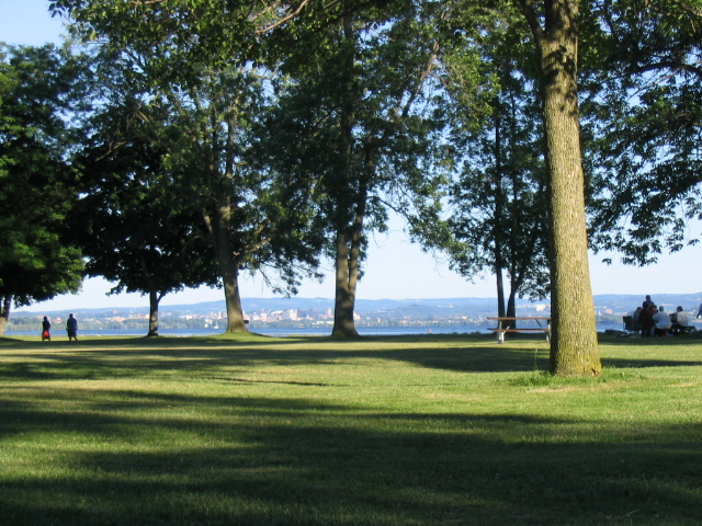
 Onondaga Lake Park in the northern suburbs of Syracuse and attracts over one million visitors each year
Onondaga Lake park
See also: Onondaga Lake ParkOnondaga Lake Park, hugs the eastern shore of the lake and is located at 6790 Onondaga Lake Trail in Liverpool. The park offers seven miles of shoreline nooks and crannies that provide options for family picnics, including developed areas in Willow Bay and Cold Springs. The park also has paved, vehicle free trails and offers free outdoor wireless internet in the Griffin Visitor Center area.[38]
Onondaga Lake Park marina
The Onondaga Lake Park Marina is located on Onondaga Lake Parkway in Liverpool.[33]
Salt museum
Included in the project was the construction of the Salt Museum which was built around a "still standing" boiling block chimney. The museum opened in 1933 and is still in operation.[34]
Wegmans Good Dog park
 Outlet on the shores of Onondaga Lake in Liverpool, New York about 1900
The Wegmans Good Dog Park was the first of its kind in Central New York and is located in the Cold Springs Mud Lock[39] section of Onondaga Lake Park. It is open from sunrise to sunset, seven days a week year round.[38]
Dogs are allowed to exercise without leashes in a 40,000 sq ft (3,700 m2) fenced in area which includes an exercise area with tunnels, jumps and bridges complete with red fire hydrants.[38]
Dog etiquette guidelines and park rules have been established by the Onondaga County Parks Department and are strictly enforced. Pets must be under control at all times and owners must be able to show proof of vaccination.[38]
Entrance to the park is located at 49 Cold Springs Trail in Liverpool off NYS Route 370. Suggested donation of $1 per person at the main gate. The park is maintained with private donations.[38]
Lake events
 Sailboating on the lake in 1907
- Syracuse Hydrofest - The North American championship of hydroplane racing - annual event in the Willow Bay area of Onondaga Lake Park in mid-June.
- Lights on the Lake - Onondaga Lake Park in Liverpool from late November to early January.
References
- ^ New York State Department of Environmental Conservation (October 2008). "Citizen Participation Plan for the Onondaga Lake Bottom Subsite Remedial Design Program". p. 15. http://www.dec.ny.gov/docs/regions_pdf/cpponlake.pdf. Retrieved 21 April 2011.
- ^ a b c d Matthews, David A.; Steven W. Effler, Carol M. Matthews (Brooks) (Nov.-Dec. 2000). "Ammonia and Toxicity Criteria in Polluted Onondaga Lake, New York". Water Environment Research 72 (6): 731–741.
- ^ a b c d Driscoll, Charles T.. "Background of Onondaga Lake". Mercury in Onondaga Lake. http://www.ecs.syr.edu/faculty/driscoll/personal/Background%20Onon%20Lake.asp. Retrieved 4 April 2011.
- ^ "Onondaga Lake Watershed". Onondaga Lake Partnership. http://www.onlakepartners.org/onlakewatershed.htm.
- ^ a b c "Onodaga Lake". The Upstate Freshwater Institute (UFI). http://www.upstatefreshwater.org/html/onondaga_lake.html. Retrieved 4 April 2011.
- ^ a b c "Onondaga Lake". Onondaga Lake Partnership. http://www.onlakepartners.org/lake.htm. Retrieved 4 April 2011.
- ^ a b c d "Onondaga Lake". The Upstate Freshwater Institute. http://www.upstatefreshwater.org/html/onondaga_lake.html.
- ^ a b c "Onondaga Lake". US Environmental Protection Agency. http://www.epa.gov/region02/superfund/npl/0203382c.pdf.
- ^ http://www.onondaganation.org/land/olake.html
- ^ http://www.onondaganation.org/lake_vision.html
- ^ a b c d e f "Human Use of Onondaga Lake". Onondaga Lake Partnership. http://www.onlakepartners.org/lake_human.htm.
- ^ a b c d e Kappel, William M.. "Salt Production in Syracuse, New York ("The Salt City") and the Hydrogeology of the Onondaga Creek Valley". Department of Interior U.S. Geological Survey. http://ny.water.usgs.gov/pubs/fs/fs13900/FS139-00.pdf.
- ^ "Citizen Participation Plan for the Onondaga Lake Bottom Subsite Remedial Design Program". New York State Department of Environmental Conservation. http://www.dec.ny.gov/docs/regions_pdf/cpponlake.pdf.
- ^ "Onondaga Lake: We Stand at a Fork in the Road". Syracuse Peace Council. http://www.peacecouncil.net/pnl/07/762/onlake1.jpg.
- ^ a b "History of Onondaga Lake". Onondaga Community College, 2010. http://students.sunyocc.edu/central.aspx?menu=542&id=13388. Retrieved November 20, 2010.
- ^ a b c d e f "Honeywell & Onondaga Lake: A Timeline". Onondaga Nation. http://www.onondaganation.org/land/off_honeywell_time.html.
- ^ a b c d e f "Water Quality in the Past". Onondaga Lake Partnership. http://www.onlakepartners.org/lake_quality_17-20.htm.
- ^ a b c "Onondaga Lake Contaminants of Concern". Onondaga Nation. http://www.onondaganation.org/land/olake_contam.html.
- ^ a b c "Region 2: Onondaga Lake". US Environmental Protection Agency. http://www.epa.gov/region2/water/lakes/onondaga.htm.
- ^ a b "Pollutants & Onondaga Lake". Onondaga Lake Partnership. http://www.onlakepartners.org/lake_quality_pollutants.htm.
- ^ a b "Onondaga Lake Contaminents of Concern". Onondaga Nation. http://www.onondaganation.org/land/olake_contam.html.
- ^ a b "Cleanup: Industrial Chemicals". Onondaga Lake Partnership. http://www.onlakepartners.org/cleanup_industrial.htm.
- ^ a b c d e f g "A Historical Perspective". New York State Department of Environmental Conservation. http://www.dec.ny.gov/docs/regions_pdf/oltimeline.pdf.
- ^ "Fish". Onondaga Lake Partnership. http://www.onlakepartners.org/lake_fish.htm.
- ^ "Onondaga Lake Superfund Site". New York State Department of Environmental Conservation. http://www.dec.ny.gov/chemical/8668.html.
- ^ a b c d e f "Onondaga Lake Superfund Site". US Department of Environmental Conservation. http://www.onlakepartners.org/cleanup_municipal.htm.
- ^ a b c "Legal Foundation for Onondaga Lake Cleanup". Onondaga Lake Partnership. http://www.onlakepartners.org/cleanup_legal.htm.
- ^ "Cleanup: Municipal Wastewater". Onondaga Lake Partnership. http://www.onlakepartners.org/cleanup_municipal.htm.
- ^ a b c "The Onondaga Lake "Cleanup" Plan". Onondaga Nation. http://www.onondaganation.org/land/olake_cleanup.html.
- ^ a b "Onondaga Land Rights Action Background". Neighbors of Onondaga Nation. http://www.peacecouncil.net/NOON/landrights.html.
- ^ Kehow, Robert. "Neighbor to Neighbor, Nation to Nation: Water Connects Us All". Syracuse Peace Council. http://www.peacecouncil.net/NOON/articles/water4-05.html.
- ^ "Onondaga Nation Announce Land Rights Action Promising No Evictions and No Casinos". Neighbors of Onondaga Nation. http://www.peacecouncil.net/NOON/articles/nationPR.html.
- ^ a b c "Onondaga Lake Park Longbranch Park". Syr-Area.com , 2010. http://syr-area.com/cny-parks/onondaga-lake-park.html. Retrieved November 7, 2010.
- ^ a b Bell, Valerie Jackson. "The Onondaga New York Salt Works (1654 - 1926)". Science Tribune, October 1998. http://www.tribunes.com/tribune/sel/bell.htm. Retrieved November 5, 2010.
- ^ a b "Welfare Bureau Has Option at $500 an Acre on Former Railroad Property Near Proposed Highway". Syracuse Journal (Syracuse, New York). September 24, 1933.
- ^ a b "Long Branch Park". Onondaga County Parks, 2010. http://onondagacountyparks.com/olp/long-branch. Retrieved November 7, 2010.
- ^ a b "Sainte Marie among the Iroquois". VirtualTourist, 2010. http://www.virtualtourist.com/travel/North_America/United_States_of_America/New_York_State/Syracuse-843193/Off_the_Beaten_Path-Syracuse-BR-1.html. Retrieved November 5, 2010.
- ^ a b c d e "Onondaga Lake Park". Onondaga County Parks, 2010. http://onondagacountyparks.com/olp. Retrieved November 7, 2010.
- ^ "Directions". Onondaga County Parks, 2010. http://onondagacountyparks.com/olp/directions. Retrieved November 7, 2010.
External links
- Onondaga Lake Improvement Project
- Onondaga Lake Partnership
- U.S. Environmental Protection Agency: Onondaga Lake
- Superfund site information for Onondaga Lake
- Our Lake: Central NY Near-Real-Time Surface Water Quality Network
- USA Today: Honeywell agrees to spend $451 million to clean up NY lake
- U.S. Water News Online: State proposes clean up contamination that creates one of world's most polluted lakes
- 1988: David Yarrow halts construction of a new shopping mall on the Onondaga Lake shore, warning of hazardous wastes and gasoline under the site, and of the existence of Kaneenda, an ancient Onondaga Indian fishing village.
- Onondaga Lake Park Marina, 2010
Categories:- Lakes of New York
- Superfund sites
- Geography of Onondaga County, New York
- Syracuse, New York


Wikimedia Foundation. 2010.