- Mid-Canada Line
-
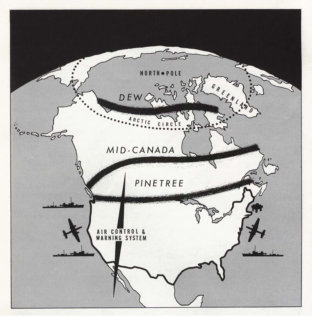
 A rough map of the three warning lines. From north to south: Distant Early Warning Line, Mid-Canada Line, and Pinetree Line.
 Sikorsky H-19 at the Canadian Museum of Flight 1988.The aircraft is painted as it would have looked while working on the construction of the Mid-Canada Line
The Mid-Canada Line, also known as the McGill Fence, was a line of radar stations across the "middle" of Canada to provide early warning of a Soviet bomber attack on North America. It was built to supplement the less-advanced Pinetree Line, which was located further south. The majority of Mid-Canada Line stations were used only briefly from the late 1950s to the mid-1960s, as the attack threat changed from bombers to ICBMs; the early warning role passed almost entirely to the more capable DEW Line further north.
Contents
History
Impetus
Construction of the Pinetree Line had only just started when air planners started to have concerns about its capabilities and siting. By the time it detected a potential attack by jet-powered aircraft, there would be little time to do anything before the attack reached Canadian or northern U.S. cities. Additionally the Pinetree systems used "old" pulse-based radars that were fairly easy to jam and were unable to detect targets close to the ground due to scattering. Although expensive in terms of fuel use, it would be possible for Soviet bombers to evade detection by flying lower. They would eventually be seen as they approached the stations, but possibly so late that there would be no possibility of intercepting them. This made the Pinetree Line's usefulness somewhat suspect even before it had become operational.
Dr. W.B. Lewis, head of the AECL Chalk River Laboratories and former Chief Superintendent of the UK Telecommunications Research Establishment (TRE) had proposed to the Defence Research Board (DRB) a Doppler radar system that avoided both of these problems. Known today as a "forward scatter bistatic radar", it used two antennas, a transmitter and receiver, separated by about 60 km. Any aircraft flying between the antennas would be detected when it entered the beam and changed the received signal. Since the system relied on the speed of the aircraft to "shift" the frequency due to the Doppler effect, the radar could be aimed at static objects like the ground; although a signal would be reflected and received, since the ground is not moving this signal has no shift and can be easily filtered out.
Another advantage of the system is that it requires much less power to operate effectively. A conventional pulse radar spends most of its time turned off, listening for the reflections of its own signal. To ensure the reflections have enough energy to be detected, each pulse has to be extremely powerful. In a bistatic radar the signal is continually broadcasting and even tiny changes in the frequency can be seen and amplified, so a much smaller signal is needed. Compared to the existing Pinetree radars, Lewis' system would require much smaller sites and less power.
The major disadvantage of the system is that it did not indicate the aircraft's location within the beam, simply an indication of which beam had been "broken". Lewis proposed a system in which two overlapping lines of stations would be set up, forming a continuous "fence". This not only allowed one of the lines to cover the dead points directly over the antennas of the other, but also allowed for location within 30 km depending on which pair of beams were broken – a distance well within the detection ranges of interceptor aircraft radar. Lewis' design would be able to see any aircraft from ground level up to 65,000 ft.
Spider Web
The DRB decided to pursue Lewis’ idea in 1950-51 by directing a research contract to the Eaton Electronics Research Laboratories of McGill University, headed by Professor Garfield Woonton. Lewis suggested to DRB and Woonton that he put the project in the hands of Associate professor, Dr. J. Rennie Whitehead as project leader, working for the University on behalf of the Defence Research Board. Some preliminary tests were made in 1952 with 'breadboard' hardware, built by a graduate student, Hugh Hamilton, in order to confirm the validity of the idea.
In the meantime RCA Victor had been brought in by the DRB to design and produce the receivers, transmitters and antennae for tests on a substantial scale. The testing was performed in the summer of 1953, when Whitehead and his team of RCA Victor and RCAF personnel installed and operated a string of seven stations stretching from Ottawa to Mattawa along the Ottawa River valley. Known under the code name of "Spider Web", the tests were made with aircraft from Air Defence St. Hubert, near Montreal. All observations were transmitted to and made in the line HQ, which was set up in the equipment hut of one of the seven stations in Deep River. Andrew Matthews of the 104 Communications Flight at RCAF St. Hubert arranged for a series of different aircraft to fly through the network, including an Auster light aircraft, a T-33 Shooting Star, an Avro Lancaster bomber and even a recently acquired de Havilland Comet jet transport. The tests revealed a great deal about the spectral ‘signatures’ of aircraft crossing the line at different points, and demonstrated the capability to detect all sizes of aircraft from 100 ft to over 40,000 ft in altitude. During this time Dr. Ross Warren of RCA Victor and Dr. Whitehead jointly developed the theoretical background for the work in a major report to DRB.
The Spider Web trials were followed in 1954 by intensive tests on a single link, built in the Eastern Townships for Bell who had by this time been given the go-ahead for the implementation of the Mid-Canada Line. The trials on this prototype link were also conducted by Whitehead and a small team in collaboration with Air Defence Command, St. Hubert, this time on behalf of Bell. The trials involved the flyover of numbers of B-52 bombers by arrangement with Strategic Air Command and a local bombplot unit. They also had full-time use of an Avro Lancaster from CFB Greenwood for the important low-level tests. The senior uniformed member of the team, Flight Lieutenant Andy Matthews, arranged and navigated all the Spider Web and Eastern Township flight tests.
Deployment studies
In February 1953 the Canada-U.S. Military Study Group (MSG) was asked "to study those aspects of the North American Air Defence System in general, and the early warning system in particular, which are of mutual concern to the two countries." The MSG then asked the air defence commanders of Canada and the United States to prepare independent briefs on the subject. By July 1953, RCAF Air Defense Command had completed its brief, followed shortly thereafter by its USAF counterpart. Both reports suggested building a Doppler fence farther north, along the 55th parallel north, roughly at the entrance of James Bay into Hudson Bay.
In October 1953 the MSG recommended to both governments "that there be established at the earliest practicable date, an early warning line located generally along the 55th parallel between Alaska and Newfoundland", and outlined their minimum operational requirements. By the end of November 1953, the Mid-Canada Line had been approved in principle. Unlike the jointly-operated Pinetree line and future DEW line, the Mid-Canada line would be funded and operated entirely by the RCAF. The DRB estimated that the system would cost about $69,700,000, while an independent RCAF report placed it at $85,000,000.
In December an effort started to try to understand what sort of problems would be encountered during construction. Several "trains" consisting of tractor-pulled sleighs set out cross-country. One, manned by the RCAF, set out eastward from Fort Nelson, BC in order to link up with a second moving west from Flin Flon, Manitoba, while a third crewed by the Army left Lake Nipigon near Thunder Bay, Ontario for Lansdown House about 200 km further north. The missions proved that it was possible to build the new line, but only during the winter when the muskeg was frozen solid. These missions also inspired the U.S. Army to invest in purpose-built overland trains which they experimented with in the 1960s but never put into production.
While that was taking place, efforts were underway to start primary siting studies. It quickly became clear that the areas in question, at least in eastern Canada, were so remote that there was no really accurate topographical information. A huge effort to map the area in a 15-mile wide strip across the entire country was started by Transport Command almost immediately, and ended by the spring of 1954. With this information in hand a construction division was set up, the Systems Engineering Group (SEG), in February 1954, tasked with producing a final report on the system to be submitted on June 1.
Finalizing the plans
As the experiments continued it became clear that the radar stations could be located further apart, up to 90 km, reducing the number of stations required. Nevertheless the price rose, now estimated at about $120,000,000. Although their final report was not yet ready, the SEG put in an interim report in June and it was approved by cabinet by the end of the month.
In their report they outlined the system that would be built almost exactly. It called for eight major Sector Control Centres, numbered from 200 to 900, each of which control up to thirty unmanned radar sites for a total of 90 radar stations. Each of the radar stations consisted of a single tall mast with a number of small dishes in fixed positions on top (typically four, two pointed in either direction), with power and electronics located in a building below the mast.
The sector control centres were linked using an advanced microwave communications system developed in part by CADRE, which scattered off the troposphere for long-distance communications. The southernmost site along the eastern portion of the line, at Cape Henrietta Maria on Hudson Bay, was used as the main communications point, and three additional repeater stations transferred data from the line southward to the NORAD command center in North Bay, Ontario. The easternmost station at Hopedale, Labrador was co-located with an existing Pinetree Line station in order to save construction costs.
All aircraft transiting the line would have to file a flight plan through the Mid Identification Zone, or MIDIZ, centred on the fence. The plans also called for the construction of several airbases known as Line Clearance Aerodromes just to the north of the line, where interceptor aircraft could operate in times of heightened alert.
At about this time another huge civil engineering project was underway in Canada, the construction of a cross-Canada microwave relay telephone system. Since many of the logistics problems were similar, the construction group, led by Bell Canada, was selected as a major contractor for the base construction. Detailed site selection started in 1955, with a major surveying effort running across Canada at the 55th parallel. The sites were so remote that the RCAF had to form up its first all-helicopter squadron in order to provide flight support for the survey teams.
Construction and service
Construction started in 1956 and proceeded quickly. By April 1957 the eastern half was operational, and the line was declared fully operational on January 1, 1958. Operations were shortly integrated into the newly-formed NORAD. Even the SEG's revised estimates turned out to be too low, and the fence's final cost is estimated at $224,566,830.
It was not long before the RCAF started to have reservations about the costs of maintaining the Line. Although technically more capable than Pinetree, the MCL gave little information in terms of planning a response or vectoring interceptors to their targets, these tasks still required the Pinetree radars much further south. The extra time offered by the MCL was not considered worth the trouble of keeping the line operational. Even before the line became operational, in a repeat of earlier history, a new and more capable line was already under study that would combine the plotting capability of the Pinetree system with the line-breaking capabilities of the MCL, and located much further north to dramatically improve the detection and response times. Emerging as the Distant Early Warning Line, or DEW, construction started before the MCL had become operational.
When the DEW line became operational in 1957 the value of the MCL was eroded, and the RCAF started pressing for it to be dismantled. The USAF disagreed, but the western half of the line was shut down in January 1964, leaving the eastern half to help defend the industrial areas of Canada and the US. However as the Soviet Union moved their offensive capability to ICBMs it became clear that both the MCL and Pinetree systems were of limited use, and the entire Mid-Canada line was shut down in April 1965.The operations site located at Cranberry Portage, Manitoba, for example, has been converted into a high school and residence since active operations at the site closed in the mid-1960s.
Interestingly the MIDIZ remains administratively operational, although transit across it is not enforced.[citation needed]
References
- Maj. D.H. Thorne, The Mid Canada Line, 1958 - 1965
- James Rennie Whitehead , Memoirs of a Boffin, Chapter 7: The McGill Fence
See also
External links
- The Mid-Canada Line: includes maps and photos from most of the stations
 Canada in the Cold War
Events Defectors Alleged Soviet Agents Military NORAD · DEW Line · Mid-Canada Line · Pinetree Line · Canadian Forces Europe · Avro Canada CF-105 Arrow · Canada and weapons of mass destruction · Bomarc MissileOther Emergency Government Headquarters · Canada – Soviet Union relations · Young Communist League of Canada · E. Herbert Norman · Kellock–Taschereau Commission Canadian Forces bases and stations
Current CFB Borden · CFB Edmonton · CFB Gagetown · CFB Kingston · CFB Montreal · CFB Petawawa · CFB Shilo · CFB St. Hubert · CFB Suffield · CFB Valcartier · CFB Wainwright · LFAATC Aldershot · LFCATC MeafordCFB Bagotville · CFB Borden · CFB Comox · CFB Cold Lake · CFB Gander · CFB Goose Bay · CFB Greenwood · CFB Kingston · CFB Moose Jaw · CFB North Bay · CFB Trenton · CFD Mountain View · CFB WinnipegAll servicesDND Headquarters · CFS Alert · CFS Leitrim · CFNA HQ Whitehorse · CFNA HQ Yellowknife · Camp Nathan Smith · ASU Saint-JeanDefunct BasesCFB Calgary · CFB Baden-Soellingen · CFB Chatham · CFB Chilliwack ASU Chilliwack · CFB Clinton · CFB Cornwallis · CFB Downsview Denison Armoury · CFB Griesbach · CFB Lahr · CFB London · CFB Moncton · CFB Ottawa · CFB Penhold • CFB Picton · CFB Portage la Prairie · CFB Rivers · CFB Rockcliffe · CFB Shearwater · CFB St. Jean · CFB Summerside · CFB Toronto · CFB Uplands · CFB WinnipegStationsCFS Aldergrove · CFS Alsask · CFS Armstrong · CFS Baldy Hughes · CFS Barrington · CFS Beausejour · CFS Beaverlodge · CFS Bermuda · CFS Carp · CFS Chibougamau · CFS Churchill · CFS Cobourg · CFS Coverdale · CFS Dana · CFS Debert · CFS Falconbridge · CFS Flin Flon · CFS Foymount · CFS Frobisher Bay · CFS Gloucester · CFS Gypsumville · CFS Holberg · CFS Kamloops · CFS Ladner · CFS Lac St. Denis · CFS Lowther · CFS Masset · CFS Mill Cove · CFS Moisie · CFS Mont Apica · CFS Moosonee · CFS Newport Corner · CFS Ramore · CFS Senneterre · CFS Shelburne · CFS Sioux Lookout · CFS Sydney · CFS Val-d'Or · CFS Whitehorse · CFS YorktonTemporary basesCanada Dry One • Canada Dry Two • Camp Julien • Camp Mirage Royal Canadian Air Force 
Chief of the Air Staff · Installations · List of aircraft
History: Canadian Aviation Corps (1914-1915) · Canadian Air Force (1918-1920) · Canadian Air Force (1920-1924) · Royal Canadian Air Force (1924-present)
Snowbirds · List of Wings 1 Wing Kingston · 3 Wing Bagotville · 4 Wing Cold Lake · 5 Wing Goose Bay · 8 Wing Trenton · 9 Wing Gander · 12 Wing Shearwater · 14 Wing Greenwood
15 Wing Moose Jaw · 16 Wing Borden · 17 Wing Winnipeg · 19 Wing Comox · 22 Wing North Bay - List of Squadrons
Training: Canadian Forces School of Aerospace Technology and Engineering

Bases CONUSAdair · Beale · Bong (unbuilt) · Charleston · Davis-Monthan · Dobbins · Dover · Dow · Duluth · England · Ent · Ethan Allen · Fairfax · Fort Lee · Geiger · George · Glasgow · Grand Forks · Grenier · Griffiss · Gunter · Hamilton · Hancock · Homestead · Hurlburt · Imeson · K.I. Sawyer · Kincheloe · Kingsley · Kirtland · Larson · Luke · March · Malmstrom · McCoy · McChord · McClellan · McGhee Tyson · McGuire · Minneapolis-St. Paul · Minot · Mitchel · New Castle · Niagara Falls · Norton · O'Hare · Oklahoma City · Otis · Oxnard · Paine · Perrin · Peterson · Pittsburgh · Pope · Portland · Presque Isle · Richards-Gebaur · Selfridge · Seymour Johnson · Sioux City · Snelling · Stead · Stewart · Suffolk County · Tinker · Travis · Truax · Tyndall · Vandenburg · Webb · Westover · Willow Run · Wright-Patterson · Wurtsmith · Youngstown
OverseasErnest Harmon · Frobisher Bay · Goose Bay · Keflavik · Pepperrell · Thule · Topsham

Stations CONUSAlmaden · Charleston · Clear · Cross City · Benton · Empire · Mill Valley · Montauk · Mount Hebo · North Truro · Point Arena · Rye · Thomasville · Watertown
OverseasAlbrook
Air
Defense
unitsForcesAir
DivisionsSectorsAlbuquerque · Bangor · Boston · Chicago · Detroit · Duluth · Goose · Grand Forks · Great Falls · Iceland · Kansas City · Los Angeles · Minot · Montgomery · New York · Oklahoma City · Phoenix · Portland · Reno · Sault Sainte Marie · San Francisco · Seattle · Sioux City · Spokane · Stewart · Syracuse · Washington
WingsGroups1st · 4th · 10th · 14th · 15th · 23rd · 32nd · 33rd · 50th · 52nd · 53rd · 54th · 56th · 57th · 73rd · 78th · 79th · 81st · 82nd · 84th · 325th · 326th · 327th · 328th · 329th · 337th · 355th · 408th · 412th · 414th · 473rd · 475th · 476th · 478th · 500th · 501st · 502d · 503d · 507th · 514th · 515th · 516th · 517th · 518th · 519th · 520th · 521st · 525th · 527th · 528th · 529th · 530th · 533d · 534th · 564th · 566th · 567th · 568th · 575th · 678th · 701st · 4676th · 4700th · 4721st · 4722d · 4727th · 4728th · 4729th · 4730th · 4731st · 4732d · 4733d · 4734th · 4735th · 4756th
SquadronsAerospace Defense Command Fighter Squadrons · Aircraft Control and Warning Squadrons
Major
weapon
systemsElectronicFightersMissiles1 · 2 · 3 · 4 · 5
ShipsGuardian · Interceptor · Interdictor · Interpreter · Investigator · Locator · Lookout · Outpost · Pickett · Protector · Scanner · Searcher · Skywatcher · Tracer · Watchman · Vigil
Miscellaneous Air Defense Command Emblem Gallery (On Wikimedia Commons) · General Surveillance Radar StationsCategories:- Royal Canadian Air Force
- Military history of Canada
- Radar networks
- Cold War
- Canada–United States relations
- Radar stations of the United States Air Force
- Aerospace Defense Command
- Closed facilities of the United States Air Force

Wikimedia Foundation. 2010.