- Arroyo, Puerto Rico
Infobox Settlement
settlement_type =
subdivision_type = Country
subdivision_name =United States subdivision_type1 = Territory
subdivision_name1 =Puerto Rico
subdivision_type2 =
subdivision_name2 =timezone=AST
utc_offset=-4
timezone_DST=
utc_offset_DST=
unit_pref=Imperial
map_caption =Location of PAGENAME within Puerto Rico.
latNS=N
longEW=W| official_name = Arroyo, Puerto Rico | nickname = Pueblo Ingrato-Pueblo Grato", "Los Bucaneros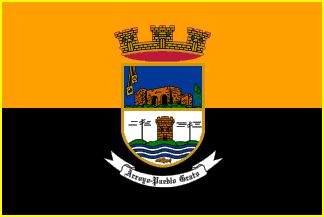 | image_
population_blank1 = Arroyanos|population_blank1_title=Gentilic|
population_blank1 = Arroyanos|population_blank1_title=Gentilic|
| map_caption = Location inPuerto Rico
established_date = December 25, 1855|established_title=Founded| leader_title =Mayor | leader_title=Mayor
leader_name = Hon. Basilio Figueroa de Jesús
political party = Partido Nuevo Progresista
leader_party = PNP
leader_title1=Senatorial dist.
leader_name1= 7 Humacao
leader_title2=Representative dist.
leader_name2 = 30| area_magnitude = 1 E9 | area_total_km2 = 59.6
area_land_km2 = 39| area_water_km2 = 20.6| population_as_of = 2000 | population_note =
population_total = 20219|population_footnotes= | population_density_km2 = 507| timezone = AST | utc_offset = -4 | timezone_DST = | utc_offset_DST = -4| latitude =
longitude = | website = | footnotes = Anthem – "Arroyo"Arroyo (ah-RO-yo), is a
municipality in the Southern Coastal Valley ofPuerto Rico and bordered by the Caribbean Sea, east of the municipality of Guayama and northwest of the municipality of Patillas. Arroyo is spread over 5 wards and Arroyo Pueblo (The downtown area and the administrative center of the city).History
Arroyo, founded in December 25, 1855, derives its name from the small stream from which weary travelers in the past stopped for a drink of water and to rest.
Arroyo is known as "Pueblo Grato".
Flag
It has two horizontal bands of equal size. The orange and black colors keep alive a past filled with adventure and accomplishment. The Coat of Arms is placed in the center of the flag.
Coat of Arms
Cut into the upper blue field a church, a rosary to the right and a flower to the left. At the base, a tower between two silver telegraph poles on green hills. At the bottom waving stripes of blue and silver, and below these, a fish. Above the shield, lies a crown of three towers filled in with purple. Below there's a banner with the motto, Arroyo Pueblo Grato (Arroyo Pleasing Town).
Demographics
Barrios (Districts/Wards)
Geo/Topography
Anthem
Arroyo, Arroyo pueblo grato sol de Dios,
sale entre tus palmeras tus riberas
dan al Mar Caribe soy de Arroyo,
cuna que me vio nacer.Riachuelo que surgió de las aguas del Río Yaurel
que fuera incitador de tu noble fundación.
Pitahaya cual región nuestro Indio comenzó
a explotar y a cultivar nuestras tierras antes de Colón.Grandes fueron y son nuestras personas
Samuel F. B. Morse e Isabelino Cora,
Max Sánchez, Don Jesús María,
Don Cristóbal Sánchez y Don José de Choudens.Y en nuestra educación
Cayetano Sánchez, Javier Amy,
Juan B. Huyke, Mrs. Gallart,
Mrs. Quiñones y Carmen Bozello.Nuestra historia transcurrió no
podemos olvidar la central de
Lafayette, la Sierrita y a Nicasio Ledee.Arroyo, Arroyo pueblo grato sol de Dios,
sale entre tus palmeras tus riberas dan al mar caribe.
Soy de Arroyo cuna que me vio nacer,
soy de Arroyo cuna que me vio nacer.Economic
The owner of Lafayette was known as Federico Basora Aldecoa.He was very rich.He was also the owner of the theater next to the panaderia and reposteria La Familia and The Supermercados Ola.The theater is located near the Plaza.For more information call the "Alcaldia",Hon.Basilio Figueroa (Mayor).
Business
Arroyo's Hospital Lafayette is one of the oldest private hospitals in the southeast of the island. Also, Stryker a major medical implements fabricator; has a production plant near the "Cuatro Calles" sector.
Industrial
Tourism
Landmarks and places of interest
*Enrique Huyke Monument
*La Cora Hacienda
*Las Palmas Beach
*Old Tower
*Punta Guilarte Beach - considered one of the most beautiful beaches on the island.
*Punta de Las Figuras Lighthouse Ruins
*Samuel F. B. Morse Monument
*Wind MillFestivals and events
*Arroyo Carnival- February
*"Fiesta Negra" - March
*Cross Rosaries - May
*"Fiestas Patronales" - July
*Fish Festival - November
*Christmas Festival - DecemberTransportation
Education
=Sports= Arroyo is a very good place to be when it comes to Class "A" Baseball. The teams of Antigua and Yaurel are the most predominant ones.Reported by, Carlos Gonzalez
Notable "Arroyanos"
*Héctor 'Picky' Soto - volleyball player
*Enrique Huyke
*Francisco J. Amy
*Galio Ortíz
*José Manautou Fantauzzi
*José Ramón Quiñones
*Juan B. Huyke - Educator, journalist, lawyer, politician and writer
*Marcelina Cintrón
*Zayra Alvarez
*Ramón Rivera Lavalet - Educator, Public Servant, Public Health Administrator
*Lutgarda Cartagena Rivera - Public Servant, mother of Rev Elias Fernández first Catholic Priest ordained in Arroyo
*Jose "Cheo" Cruz - former professional baseball player. His #23 was retired by theHouston Astros .
*Lieutenant Colonel Teofilo Marxuach - OnApril 6 ,1917 , fired the first shot ofWorld War l on behalf of the United States.
*Alick Gittens
*Juan Enrique Montes - AthleteReferences
Footnotes
Books about Arroyo
Additional Information
Photo gallery
External links
* [http://www.topuertorico.org/city/arroyo.shtml Welcome to Puerto Rico Arroyo]
* [http://www.puertohost.com/maps/arroyo-map.php Map of Arroyo Puerto Rico]
* [http://www.rincondeltiempo.com Arroyo Weather Station Live]
Wikimedia Foundation. 2010.