- Cidra, Puerto Rico
-
Cidra, Puerto Rico, United States — Municipality — 
FlagNickname(s): La Ciudad de la Eterna Primavera (City of Eternal Spring) Anthem: "Del corazón de Puerto Rico nació Cidra" Location of Cidra in Puerto Rico
Coordinates: 18°10′33″N 66°09′41″W / 18.17583°N 66.16139°WCoordinates: 18°10′33″N 66°09′41″W / 18.17583°N 66.16139°W Founded 1809 Government – Mayor Ángel L. Malavé Zayas (PNP) – Senatorial dist. 6 - Guayama – Representative dist. 29 Area – Total 94.42 km2 (36.5 sq mi) – Land 94 km2 (36.3 sq mi) – Water .42 km2 (0.2 sq mi) Population (2009) – Total 49,250 – Density 521.6/km2 (1,351/sq mi) Demonym Cidreños Time zone AST (UTC-4) Zip code FIPS code 72-18074[1] GNIS feature ID 1610092[2] Cidra (Spanish pronunciation: [ˈθiðɾa]) is a municipality of Puerto Rico located in the central region of the island, north of Cayey; south of Comerío and Aguas Buenas; east of Aibonito and Barranquitas; and west of Caguas. Cidra is spread over 12 wards and Cidra Pueblo (The downtown area and the administrative center of the city). It is part of the San Juan-Caguas-Guaynabo Metropolitan Statistical Area.
Cidra is known as La Ciudad de la Eterna Primavera (City of Eternal Spring).
Contents
History
Cidra was founded in 1809.
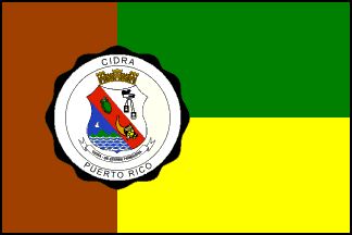
Flag
The Municipal Seal shines on the flag uniting all three stripes, and the whole is ended with yellow fringes. The green evokes the landscape which is green throughout the year and which covers all the land with an immense variety of colored flowers. It is the reason why the town is called "Town Of The Eternal Spring". The gold color refers to the richness of its fruits and hydrography as well as the spiritual wealth of the region and its citizenship. The brown alludes to the Virgin Carmen, patron of the cidreños, and to the Savannah Dove, which is a unique species in the world that has its habitat in this municipality.
Coat of Arms
Over the red band it has a gold "cidra" and a cornucopia with its fruit in natural color, which alludes that Cidra is one of the major producers of fruit of the Island. In the superior right is placed a scapulary that evokes the Virgin Carmen, patron of the town, and a black bishop hat that alludes to San Juan Nepomuceno, bishop and martyr. In the left inferior part, on a blue bottom, is located a brown Savannah Dove which nests in the Cidra area. This dove flies over a mountain of three tips, which indicates the location of the municipality in the Central Mountain Range. The blue and silver waves symbolize the aquatic wealth of Cidra. All this is capped by a three-tower crown.
Demographics
Barrios (Districts)
- Arenas
- Bayamón
- Beatriz
- Ceiba
- Certenejas
- Cidra
- Honduras
- Montellano
- Rabanal
- Rincón
- Río Abajo
- Salto
- Sud
- Toíta[3]
Geography and Topography
- Lakes: Cidra
- Ravines: Bocana & Galindo
- Rivers: Río Arroyata, Río Bayamón & Río de la Plata
Economy
Agriculture
Agriculture (citrics)
Industry
Apparel and pharmaceuticals.
Tourism
Landmarks and places of interest
- Frog's Rock
- Hamacas' Bridge
- Iberia Theater
- Lake Cidra
- Nuestra Señora del Carmen Parish
- Perico's Waterfall
- Treasure Island Hotel
Festivals and events
- Myrna Vázquez Week - February
- Matron Festivities - July
- Paloma Sabanera Festival - November
Education
Elementary
- Ceiba - Ceiba
- Ciprián Castrodad - Río Abajo
- Luis Muñoz Rivera - Cidra
- Montellano - Montellano
- Santa Clara - Arenas
- Urbana - Cidra
Elementary and Middle
- 2da unidad Clemencia Meléndez Santos - Rabanal
- Certenejas - Bayamón
- Juan D. Stubbe - Bayamón
- Pedro Maria Dominicci - Rincon
- Pedro Diaz Fonseca - Beatriz
Middle School
- Jesús T. Piñero - Cidra
High School
- Ana J. Candelas - Sud
- Luis Muñoz Iglesias - Cidra Pueblo
- Vocacional - Sud
References
- ^ "American FactFinder". United States Census Bureau. http://factfinder.census.gov. Retrieved 2008-01-31.
- ^ "Guayanilla – Populated Place". Geographic Names Information System. USGS. http://geonames.usgs.gov/pls/gnispublic/f?p=gnispq:3:::NO::P3_FID:1610861. Retrieved 2008-05-13.
- ^ "Map of Municipio de Cidra" (PDF). http://welcome.topuertorico.org/maps/cidra.pdf. Retrieved 2008-05-14.
External links
Categories:- Municipalities of Puerto Rico
- Populated places established in 1809
- San Juan – Caguas – Guaynabo metropolitan area

Wikimedia Foundation. 2010.