- Districts of Wales
-
Districts (Wales) 
Category Districts Location Wales Found in Counties Created by Local Government Act 1972 Created 1 April 1974 Abolished by Local Government (Wales) Act 1994 Abolished 1 April 1996 Possible status City Borough In 1974, Wales was re-divided for local government purposes into thirty-seven districts. Districts were the second tier of local government introduced by the Local Government Act 1972, being subdivisions of the eight counties introduced at the same time. This system of two-tier local government was abolished in 1996 and replaced with the current system of unitary principal areas.
Each district was administered by an elected district council. The council was entitled to petition for a charter granting borough status, whereupon the district became a borough and the district council a borough council headed by a mayor. In addition, a district could be granted Letters Patent granting city status.
For the list of districts before 1974, see List of urban and rural districts in Wales.
Former districts
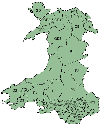
Code[1] District Status County Area 1974[2] Population estimate 1974[2] Population estimate 1992[3] Headquarters[2] Successor UA GD4 Aberconwy Borough Gwynedd 149,738 acres (605.97 km2) 49,730 54,100 Llandudno Conwy WG4 Afan renamed
Port Talbot 1 January 1986[4]
Borough West Glamorgan 37,371 acres (151.24 km2) 58,580 51,100 Port Talbot Neath Port Talbot C4 Alyn and Deeside District Clwyd 38,104 acres (154.20 km2) 68,280 74,500 Hawarden Flintshire GD1 Anglesey - Ynys Môn Borough Gwynedd 176,638 acres (714.83 km2) 62,020 69,300 Llangefni Isle of Anglesey GD3 Arfon Borough Gwynedd 101,207 acres (409.57 km2) 53,640 56,100 Bangor Gwynedd GT3 Blaenau Gwent Borough Gwent 31,318 acres (126.74 km2) 84,080 76,900 Ebbw Vale Blaenau Gwent
MonmouthshireP3 Brecknock Borough Powys 443,382 acres (1,794.30 km2) 37,120 41,500 Brecon Powys SG1 Cardiff City South Glamorgan 29,633 acres (119.92 km2) 285,760 295,600 Cardiff Cardiff D4 Carmarthen District Dyfed 291,192 acres (1,178.41 km2) 49,910 56,200 Carmarthen Carmarthenshire D1 Ceredigion District Dyfed 443,182 acres (1,793.49 km2) 55,430 67,900 Aberystwyth Ceredigion C1 Colwyn Borough Clwyd 136,566 acres (552.66 km2) 45,990 56,400 Colwyn Bay Conwy
DenbighshireMG3 Cynon Valley Borough Mid Glamorgan 44,639 acres (180.65 km2) 69,630 65,600 Aberdare Rhondda Cynon Taf C3 Delyn Borough Clwyd 6,870 acres (27.8 km2) 59,440 69,700 Flint Flintshire D6 Dinefwr Borough Dyfed 239,868 acres (970.71 km2) 36,140 38,700 Llandeilo Carmarthenshire GD2 Dwyfor District Gwynedd 152,753 acres (618.17 km2) 25,870 27,300 Pwllheli Gwynedd GT2 Islwyn Borough Gwent 24,362 acres (98.59 km2) 66,140 67,200 Blackwood Caerphilly D5 Llanelli Borough Dyfed 57,737 acres (233.65 km2) 76,720 74,600 Llanelli Carmarthenshire WG2 Lliw Valley Borough West Glamorgan 52,818 acres (213.75 km2) 57,460 64,200 Pontardawe Neath Port Talbot
SwanseaC5 Glyndŵr District Clwyd 238,686 acres (965.93 km2) 38,450 42,000 Ruthin Denbighshire
Powys
WrexhamGD5 Meirionnydd District Gwynedd 374,912 acres (1,517.22 km2) 30,830 32,900 Dolgellau Gwynedd MG4 Merthyr Tydfil Borough Mid Glamorgan 27,584 acres (111.63 km2) 61,490 60,100 Merthyr Tydfil Merthyr Tydfil GT5 Monmouth District
Borough from 1988Gwent 203,438 acres (823.28 km2) 66,090 76,700 Pontypoola Monmouthshire P1 Montgomery,
renamed Montgomeryshire 1986District Powys 510,109 acres (2,064.34 km2) 43,580 53,700 Welshpool Powys WG3 Neath Borough West Glamorgan 50,971 acres (206.27 km2) 66,150 66,300 Neath Neath Port Talbot GT1 Newport Borough Gwent 49,558 acres (200.55 km2) 135,910 137,200 Newport Newport MG1 Ogwr Borough Mid Glamorgan 70,444 acres (285.08 km2) 126,570 134,200 Bridgend Bridgend
Vale of GlamorganD2 Preseli, renamed
Preseli Pembrokeshire 1 April 1987[5]District Dyfed 258,075 acres (1,044.39 km2) 61,700 71,200 Haverfordwest Pembrokeshire P2 Radnor,
renamed Radnorshire 8 May 1989[6]District Powys 301,165 acres (1,218.77 km2) 18,670 24,000 Llandrindod Wells Powys MG2 Rhondda Borough Mid Glamorgan 23,882 acres (96.65 km2) 87,710 79,300 Pentre Rhondda Cynon Taf C2 Rhuddlan Borough Clwyd 26,860 acres (108.7 km2) 49,920 55,000 Rhyl Denbighshire MG5 Rhymney Valley District Mid Glamorgan 43,522 acres (176.13 km2) 103,800 104,000 Hengoed Caerphilly D3 South Pembrokeshire District Dyfed 134,640 acres (544.9 km2) 37,060 42,700 Pembroke Dock Pembrokeshire WG1 Swansea City West Glamorgan 60,504 acres (244.85 km2) 190,370 189,400 Swansea Swansea MG6 Taff-Ely Borough Mid Glamorgan 41,632 acres (168.48 km2) 86,880 99,700 Pontypridd Rhondda Cynon Taf
CardiffGT4 Torfaen Borough Gwent 31,258 acres (126.50 km2) 88,870 91,300 Pontypool Torfaen SG2 Vale of Glamorgan Borough South Glamorgan 73,198 acres (296.22 km2) 106,490 114,800 Barry Vale of Glamorgan C6 Wrexham Maelor Borough Clwyd 90,569 acres (366.52 km2) 106,800 117,200 Wrexham Wrexham ^a Outside the district.
References
- ^ Local Government Act 1972 c.70. Schedule 4: Local Government Areas in Wales, Part II: Districts
- ^ a b c Local government in England and Wales: A Guide to the New System. London: HMSO. 1974. pp. 97–109; 243–250. ISBN 0117508470.
- ^ OPCS Key Population and statistics 1992 cited in Whitaker's Concise Almanack 1995. London: J Whitaker & Sons. 1994. p. 566. ISBN 0850212472.
- ^ London Gazette: no. 50229. p. 11271. 15 August 1985.
- ^ London Gazette: no. 50470. p. 4267. 25 March 1986.
- ^ London Gazette: no. 51728. p. 5579. 10 May 1989.
Dyfed Gwent Gwynedd Mid Glamorgan Powys South Glamorgan West Glamorgan Lliw Valley • Neath • Port Talbot • Swansea
Categories:- Subdivisions of Wales
- Districts of Wales
- Former subdivisions of Wales
- Wales-related lists
Wikimedia Foundation. 2010.