- Popayán
Infobox City
official_name = Popayán
nickname = "The White City"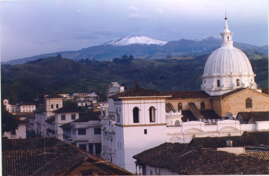
imagesize = 250px
image_caption = Downtown Popayán with Puracé volcano in the background.
image_
map_size = 250px
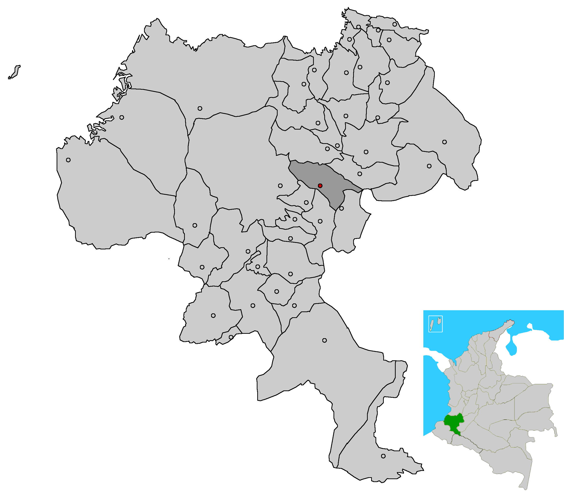
map_caption = Location of the City and municipality of Popayán in the Cauca Department.
subdivision_type = Country
subdivision_name =Colombia
subdivision_type1 = Departamento
subdivision_name1 = Cauca
leader_title =Mayor
leader_name = Víctor Libardo Ramírez Fajardo
established_title = Foundation
established_date =January 13 ,1537
area_magnitude =
area_total_km2 = 483.11
area_total_sq_mi =
area_land_km2 =
area_land_sq_mi =
area_water_km2 =
area_water_sq_mi =
area_water_percent =
area_urban_km2 =
area_urban_sq_mi =
area_metro_km2 =
area_metro_sq_mi =
population_as_of =2005 census
population_note =
population_total = 258653
population_footnotes = [http://www.dane.gov.co/files/censo2005/regiones/cauca/popayan.pdf]
population_density_km2 = 535.3
population_density_sq_mi =
population_metro =
population_density_metro_km2 =
population_density_metro_sq_mi =
population_urban =
timezone = EST
utc_offset = -5
timezone_DST = "not observed"
utc_offset_DST = -5
latd=2 |latm=27 |lats= |latNS=N
longd=76 |longm=37 |longs= |longEW=W
elevation_m = 1737
elevation_ft =
website = http://www.popayan.gov.co
footnotes =Popayán is a municipality and def. is a capital city of the
Colombia n department of Cauca, with a population of about 215,000 people. It was conquered bySebastián de Belalcázar onJanuary 13 ,1537 . It is known as the "white city" because of its beautiful colonial houses. Located at an altitude of 1,737 meters, the city is well-known for its colonial architecture and its contributions to Colombian cultural and political life. More presidents have come from Popayán than any other city in Colombia and it was also home to noted poets, painters, and composers. Here is also located the Universidad del Cauca (est. 1827), one of Colombia's oldest and most distinguished institutions of higher education. Much of the city's original splendor was destroyed onMarch 31 ,1983 , when an earthquake toppled many buildings. Though many were rebuilt and repaired, the colonial center still bears ruins and empty lots from the disaster. Nearby is Puracé National Park, a geothermal wonderland of hot springs, waterfalls, and a (currently) inactive volcano from which the park derives its name. The nearest large city isCali , in the neighbouring department ofValle del Cauca , to the north.Admnistrative Division
Popoyán have sub-divided in 23 veredas and Urban Zone
* No. 13 Cajete
* No. 09 Calibio
* No. 21 El Canelo
* No. 12 El Charco
* No. 18 El Sendero
* No. 11 El Tablón
* No. 14 Figueróa
* No. 06 Julumito
* No. 08 La Rejoya
* No. 10 La Yunga
* No. 02 Las Mercedes
* No. 03 Las Meseta, the name it's this not Las Mesetas
* No. 22 Las Piedras
* No. 15 Las Torres
* No. 01 Lso Cerillos
* No. 20 Poblazón
* No. 06 Puelenje
* No. 23 Quintana
* No. 17 Samanga
* No. 07 San Bernardino
* No. 04 San Rafael
* No. 19 Santa Bárbara
* No. 05 Santa Rosa
* Zona Urbana or Urban Zone have dividided in 9 Communes, this communes don't have a name
* Commune 1
* Commune 2
* Commune 3
* Commune 4
* Commune 5
* Commune 6
* Commune 7
* Commune 8
* Commune 9History
The word Popayán comes from an Indian dialect. It means:
Po: Two
Pa: Straw
Yan: Village
Two villages with straw roofs. However there is no straw roofs in town any more although there is plenty of them in the city neighborhood.
There are no records regarding the pre-Hispanic history of the indigenous town of Popayan, but in
January 13 ,1537 Spanish conqueror Sebastian de Belalcázar came to the conquered town and declared the foundation of Popayán. During the sixteenth and seventeenth centuries, Popayán was administered by an appointed governor under the jurisdiction of the royal audiencia, court, of Quito. It was a very important town during the colony because its location betweenLima ,Quito and Cartagena. Even after the discovery of the Pacific Ocean Popayán was a transfer point of gold and riches going to Cartagena on its way to Spain. As a result Popayán is one of the most traditional Colombian towns and very rich in Colonial architecture although in 1983 an earthquake destroyed part of the city. There are several colonial bridges, museums and churches in the town.Natives populated the town before the conquest. Next to the city there is still a huge mound built by the Indians similar to a pyramid and presently covered by grass. Legend says the inner structure holds richness and gold. Conquistadores settled next to the Indians taking advantage of their good heartiness and cheap labor. Catholicism was offered and taken by the Indians in exchange for their gold and work.The city is home to an ancient pre-Hispanic pyramid known as
El Morro del Tulcán . El Morro was already abandoned when the Spanish first arrived to the city in 1535. Analysis of dental samples taken revealed that the individuals buried there probably belonged to the most important social class from their respective Indian society.Popayán is the city with most presidents from
Colombia . A total of 17 presidents have been born in Popayán.Popayán has been destroyed by several
earthquakes . The most recent and the most destructive lasted for eighteen seconds and occurred on March 31st of1983 . The reconstruction of the colonial city took more than 10 years and still today it is possible to see some lots that have not been reconstructed. The firstearthquake seismic design code was established inColombia as a consequence of this earthquake.External links
* [http://www.popayanaldia.com Daily News]
* [http://www.aabcomp.com/photo Photo gallery]
* [http://www.skyscrapercity.com/showthread.php?t=365917/ Some pictures]
* [http://www.skyscrapercity.com/showthread.php?t=488744 Pictures about "The Little Popayán" or "El Pueblito Patojo"]
* [http://www.popayanvirtual.com/ Culture and entertaiment]
* [http://www.ciudadblanca.com/ News and entertaiment]
* [http://www.hosteltrail.com/colombia/popayan/ Online Guide based in Popayan]
* [http://www.unicauca.edu.co/ Universidad del Cauca]
* [http://www.elliberal.com.co/ Popayán Newspaper]
* [http://www.rtspecialties.com/tobar/ Popayán de mis amores]

Wikimedia Foundation. 2010.