- Ruoqiang County
-
This article is about the county. For other uses, see Ruoqiang (disambiguation).
Ruoqiang County
若羌县
چاقىلىق ناھىيىسى— County — Ruoqiang County (red) within Bayingolin Prefecture (yellow), Xinjiang, and the PRC Location in Xinjiang
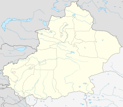
 Ruoqiang
Coordinates: 39°01′N 88°10′E / 39.017°N 88.167°ECoordinates: 39°01′N 88°10′E / 39.017°N 88.167°E Country People's Republic of China Region Xinjiang Prefecture Bayingolin County seat Ruoqiang Town Area – Total 198,318 km2 (76,571 sq mi) Elevation 896 m (2,940 ft) Population (2002) – Total 31,877 – Density 0.2/km2 (0.4/sq mi) Time zone China Standard (UTC+8) Ruoqiang (simplified Chinese: 若羌县; traditional Chinese: 若羌縣; pinyin: Ruòqiāng Xiàn, historically known as Charkliq, Chaqiliq, or Qakilik, Uyghur: چاقىلىق ناھىيىسى, ULY: Çakilik Nahiyisi) is a county of the Xinjiang Uyghur Autonomous Region in Western China and is under the administration of the Bayingolin Mongol Autonomous Prefecture. It contains an area of 198,318 square kilometres (76,571 sq mi),[1] making it the largest county-level division in China.[citation needed]
As of 2005, the county had a population of 31,877, with 18,957 (59.5%) of them having Han ethnicity, while Uyghurs numbered 11,761 (36.9%).[1]
The county seat is in Ruoqiang Town. This is the location which less-detailed maps will label as "Ruoqiang". It is at an altitude of 848 metres (2,782 ft).
Contents
History
The Kingdom of Charklik was located in what is today Ruoqiang County.
The Charkhlik Revolt took place here in 1935 when Uyghurs revolted against the Hui-dominated Tunganistan, which was controlled by the 36th Division (National Revolutionary Army). The Uyghurs were defeated.[2][3][4]
The county was established in 1902 but it was written as "婼羌" (Ruòqiāng) until 1959, when the present written form of "若羌" was adopted.[1] The Uyghur name of the county, "Çakilik", is transliterated in Chinese as "卡克里克" (Qiǎkèlǐkè).
Geography
The populated areas of the county are located mostly along the northern foothills of the Altyn-Tagh mountain range. North of this strip of irrigated agriculture and settlement is the Taklamakan Desert, south, the Altyn-Tagh and Kunlun Mountains.
The famous Lop Lake, these days usually dry, is located in the northeastern part of the county - the section officially known as the Luobu Po Town (罗布泊镇), i.e., Lop Lake Town.
The southern part of the county (administratively, Qimantag Township (祁曼塔格乡), is mountainous. The high plateau between the Altyn-Tagh and the main Kunlun range (which includes the famous Ulugh Muztagh) is known as the Kumkol Basin: an endorheic basin, where several saline lakes are found.
The three main lakes in the Kumkol Basin are Lake Aqqikkol (also known as Achak-kum; 阿其克库勒湖; 37°05′N,88°25′E, 4,250 m elevation),[5] Lake Ayakkum (Chinese: 阿牙克库木湖); 37°30′N,89°30′E; elevation 3,876 m).,[6][7] and Lake Jingyu (36°21′N 89°24′E / 36.35°N 89.4°E, 260 km2 area, 4708 m elevation).[8] These lakes are among the few noticeable bodies of water in this extremely arid area; the area around them is officially protected as the Altun Shan Nature Reserve.[6]
Climate
Ruoqiang has a desert climate (Köppen BWk), with a mean total of only 29 millimetres (1.14 in) of precipitation per annum. Winters are cold, with highs in January averaging below freezing, though temperatures rapidly rebound in February. Summers are very hot, with highs generally above 35 °C (95 °F). Monthly daily averages range from −7.4 °C (18.7 °F) in January to 27.5 °C (81.5 °F) in July; the annual mean is 11.7 °C (53.1 °F). The desert climate means that differences between day and night are generally large and sunshine is abundant year-round, totalling 3100 hours.
Climate data for Ruoqiang (1971−2000) Month Jan Feb Mar Apr May Jun Jul Aug Sep Oct Nov Dec Year Average high °C (°F) −0.5
(31.1)6.0
(42.8)15.1
(59.2)24.4
(75.9)29.9
(85.8)33.7
(92.7)35.6
(96.1)34.7
(94.5)29.5
(85.1)20.9
(69.6)10.0
(50.0)1.0
(33.8)20.0 Average low °C (°F) −13
(8.6)−8.3
(17.1)−0.8
(30.6)7.0
(44.6)12.4
(54.3)16.6
(61.9)19.2
(66.6)17.2
(63.0)11.3
(52.3)3.0
(37.4)−4.1
(24.6)−10.6
(12.9)4.2 Precipitation mm (inches) .8
(0.031).4
(0.016)1.1
(0.043).9
(0.035)1.9
(0.075)5.2
(0.205)11.5
(0.453)5.4
(0.213).4
(0.016).2
(0.008).4
(0.016).8
(0.031)29.0
(1.142)% humidity 55 41 31 27 29 35 37 36 38 43 50 57 39.9 Avg. precipitation days (≥ 0.1 mm) 1.1 .5 .5 .8 1.2 2.8 3.0 1.8 .5 .2 .2 .8 13.4 Sunshine hours 206.4 202.1 231.0 255.8 293.7 299.9 303.3 306.4 292.1 284.6 227.9 193.5 3,096.7 Source: China Meteorological Administration Transportation
Footnotes
- ^ a b c 若羌县历史沿革. Xzqh.org. Accessed 2011-05-27
- ^ Andrew D. W. Forbes (1986). Warlords and Muslims in Chinese Central Asia: a political history of Republican Sinkiang 1911-1949. Cambridge, England: CUP Archive. p. 134. ISBN 0521255147. http://books.google.com/books?id=IAs9AAAAIAAJ&pg=PA134&lpg=PA134&dq=Charkhlik+ma+hu-shan&source=bl&ots=KzhMcZekpP&sig=Z3dZBibQKK69oQWnKjieSl2g80k&hl=en&ei=rTIYTI7mMYOClAfG4ZDpCw&sa=X&oi=book_result&ct=result&resnum=3&ved=0CBgQ6AEwAg#v=onepage&q=Charkhlik%20racked%20by%20a%20uighur%20rising%20tungan&f=false. Retrieved 2010-06-28.
- ^ Forbes, Andrew D. W. (1986). Warlords and Muslims in Chinese Central Asia. CUP Archive. ISBN 9780521255141.
- ^ Peter Fleming (1999). News from Tartary: A Journey from Peking to Kashmir. Evanston, Illinois, United States: Northwestern University Press. pp. 384. ISBN 0810160714. http://books.google.com/books?id=6C2aaB3f9P4C&dq=news+from+tartary&printsec=frontcover&source=bn&hl=en&ei=GNwiTN2zDoGKlwfeh7HYDQ&sa=X&oi=book_result&ct=result&resnum=4&ved=0CCEQ6AEwAw#v=snippet&q=charklik%20executed&f=false. Retrieved 2010-06-28.
- ^ E.g. 阿其克库勒湖 (Aqqikkol Lake) on Baidu.com
- ^ a b Li, Bosheng (2000), "Chapter 11, Nature Conservation", in Zheng, Du; Zhang, Qingsong; Wu, Shaohong, Mountain geoecology and sustainable development of the Tibetan Plateau, Volume 57 of GeoJournal library, Springer, pp. 230–231, ISBN 0792366883, http://books.google.com/books?id=DuwwoxDxCYAC&pg=PA230
- ^ Or 3,870 m, according to [1] (Ayakkum Lake) on Hudong.com
- ^ 鲸鱼湖 (Lake Jingyu), on Hudong.com
References
External links
- A Tourism Guide to "Charklik / Ruoqiang - Ancient Kingdom and Outpost Gateway"[2]
Categories:- County-level divisions of Xinjiang
- Populated places in Xinjiang
- Populated places along the Silk Road


Wikimedia Foundation. 2010.