- Steuben County, New York
-
Steuben County, New York 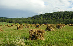 Farmland in rural Steuben County, New York
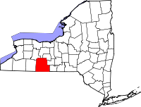
Location in the state of New York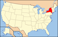
New York's location in the U.S.Founded March 12, 1772 Seat Bath Area
- Total
- Land
- Water
1,404 sq mi (3,636 km²)
1,393 sq mi (3,608 km²)
11 sq mi (28 km²), 0.82%Population
- (2010)
- Density
98,990
71/sq mi (27.4/km²)Website www.steubencony.org Steuben County (
 /stuːˈbɛn/) is a county located in the U.S. state of New York. As of the 2010 census, the population was 98,990. Its name is in honor of Baron von Steuben, a German general who fought on the American side in the American Revolutionary War, though it is not pronounced the same. Its county seat is Bath.
Contents
History
When counties were established in New York State in 1683, the present Steuben County was part of Albany County. This was an enormous county, including the northern part of New York State as well as all of the present State of Vermont and, in theory, extending westward to the Pacific Ocean. This county was reduced in size on July 3, 1766 by the creation of Cumberland County, and further on March 16, 1770, by the creation of Gloucester County, both containing territory now in Vermont.
On March 12, 1772, what was left of Albany County was split into three parts, one remaining under the name Albany County. One of the other pieces, Tryon County, contained the western portion (and thus, since no western boundary was specified, theoretically still extended west to the Pacific). The eastern boundary of Tryon County was approximately five miles west of the present city of Schenectady, and the county included the western part of the Adirondack Mountains and the area west of the West Branch of the Delaware River. The area then designated as Tryon County now includes 37 counties of New York State. The county was named for William Tryon, colonial governor of New York.
In the years prior to 1776, most of the Loyalists in Tryon County fled to Canada. In 1784, following the peace treaty that ended the American Revolutionary War, the name of Tryon County was changed to Montgomery County in honor of the general, Richard Montgomery, who had captured several places in Canada and died attempting to capture the city of Quebec, replacing the name of the hated British governor.
Ontario County was split off from Montgomery County in 1789 to form an area much larger than the present Ontario County. Steuben County was split off from Ontario County in 1796. In 1823 a portion of Steuben County was combined with a portion of Ontario County to form Yates County. Steuben County was further reduced in size in 1854 when a portion was combined with portions of Chemung and Tompkins Counties to form Schuyler County.
Geography
Steuben County is in the southwestern part of New York State, immediately north of the Pennsylvania border. The population of Steuben County according to the 2000 U. S. census was 98,726. The county is in the Southern Tier region of New York State.
According to the U.S. Census Bureau, the county has a total area of 1,404 square miles (3,640 km2), of which 1,393 square miles (3,610 km2) is land and 11 square miles (28 km2) (0.82%) is water.
Adjacent counties
- Ontario County - north
- Yates County - northeast
- Schuyler County - east
- Chemung County - east
- Tioga County, Pennsylvania - south
- Potter County, Pennsylvania - southwest
- Allegany County - west
- Livingston County - northwest
Major highways

 Interstate 86/New York State Route 17 (Southern Tier Expressway)
 Interstate 390
 U.S. Route 15
 New York State Route 15
 New York State Route 21
 New York State Route 36
 New York State Route 414
 New York State Route 415
 New York State Route 417
Demographics
Historical populations Census Pop. %± 1800 1,788 — 1810 7,246 305.3% 1820 21,989 203.5% 1830 33,851 53.9% 1840 46,138 36.3% 1850 63,771 38.2% 1860 66,690 4.6% 1870 67,717 1.5% 1880 77,586 14.6% 1890 81,473 5.0% 1900 82,822 1.7% 1910 83,362 0.7% 1920 80,627 −3.3% 1930 82,671 2.5% 1940 84,927 2.7% 1950 91,439 7.7% 1960 97,691 6.8% 1970 99,546 1.9% 1980 99,217 −0.3% 1990 99,088 −0.1% 2000 98,726 −0.4% 2010 98,990 0.3% [1][2][3] As of the census[4] of 2000, there were 98,726 people, 39,071 households, and 26,216 families residing in the county. The population density was 71 people per square mile (27/km²). There were 46,132 housing units at an average density of 33 per square mile (13/km²). The racial makeup of the county was 96.43% White, 1.36% African American, 0.27% Native American, 0.90% Asian, 0.02% Pacific Islander, 0.21% from other races, and 0.81% from two or more races. Hispanic or Latino of any race were 0.81% of the population. 18.6% were of German, 15.2% English, 14.4% American, 13.6% Irish and 8.3% Italian ancestry according to Census 2000. 96.5% spoke English and 1.3% Spanish as their first language.
There were 39,071 households out of which 31.80% had children under the age of 18 living with them, 51.70% were married couples living together, 10.60% had a female householder with no husband present, and 32.90% were non-families. 27.20% of all households were made up of individuals and 11.90% had someone living alone who was 65 years of age or older. The average household size was 2.49 and the average family size was 3.01.
In the county the population was spread out with 26.00% under the age of 18, 7.40% from 18 to 24, 27.20% from 25 to 44, 24.20% from 45 to 64, and 15.20% who were 65 years of age or older. The median age was 38 years. For every 100 females there were 96.00 males. For every 100 females age 18 and over, there were 93.20 males.
The median income for a household in the county was $35,479, and the median income for a family was $41,940. Males had a median income of $32,155 versus $24,163 for females. The per capita income for the county was $18,197. About 9.90% of families and 13.20% of the population were below the poverty line, including 18.70% of those under age 18 and 5.80% of those age 65 or over.
Cities, towns, and villages
Labels in parentheses indicate the official political level.
- Addison (village)
- Addison (town)
- Almond (village)
- Arkport (village)
- Avoca (village)
- Avoca (town)
- Bath (village)
- Bath (town)
- Bradford (town)
- Cameron (town)
- Campbell (town)
- Canisteo (town)
- Canisteo (village)
- Caton (town)
- Cohocton (town)
- Cohocton (village)
- Corning (city)
- Corning (town)
- Dansville (town)
- Erwin (town)
- Fremont (town)
- Gang Mills
- Greenwood (town)
- Hammondsport (village)
- Hartsville (town)
- Hornby (town)
- Hornell (city)
- Hornellsville (town)
- Howard (town)
- Jasper (town)
- Lindley (town)
- North Hornell (village)
- Painted Post (village)
- Prattsburgh (town)
- Pulteney (town)
- Rathbone (town)
- Riverside (village)
- Stephens Mills, New York
- Savona (village)
- South Corning (village)
- Thurston (town)
- Troupsburg (town)
- Tuscarora (town)
- Urbana (town)
- Wayland (village)
- Wayland (town)
- Wayne (town)
- West Union (town)
- Wheeler (town)
- Woodhull (town)
See also
- Steuben County Transit System
- Corning Museum of Glass
- Corning Community College
- List of counties in New York
- National Register of Historic Places listings in Steuben County, New York
References
- Richard Sherer, ed., ed (1996). Steuben County, The First 200 Years, A Pictorial History. Virginia Beach, Virginia: The Donning Company.
- Clayton, W. W. (1879). History of Steuben County, New York. Philadelphia: Lewis, Peck & Co..
External links
- Steuben County Visitors Bureau
- Steuben County, New York official government site
- Steuben County at the Open Directory Project
- Painted Hills Genealogy Society, Steuben County Page It contains a great deal of info on Steuben County.

Livingston County Ontario County Yates County Allegany County 
Schuyler County and Chemung County  Steuben County, New York

Potter County, Pennsylvania Tioga County, Pennsylvania Municipalities and communities of Steuben County, New York Cities 
Towns Addison | Avoca | Bath | Bradford | Cameron | Campbell | Canisteo | Caton | Cohocton | Corning | Erwin | Fremont | Greenwood | Hartsville | Hornby | Hornellsville | Howard | Jasper | Lindley | Prattsburgh | Pulteney | Rathbone | Thurston | Troupsburg | Tuscarora | Urbana | Wayland | Wayne | West Union | Wheeler | Woodhull
Villages Addison | Almond‡ | Arkport | Avoca | Bath | Canisteo | Cohocton | Hammondsport | North Hornell | Painted Post | Riverside | Savona | South Corning | Wayland
CDP Footnotes ‡This populated place also has portions in an adjacent county or counties
Categories:- New York counties
- Steuben County, New York
- 1772 establishments


Wikimedia Foundation. 2010.