- Pagué District
Infobox Settlement
official_name=Pagué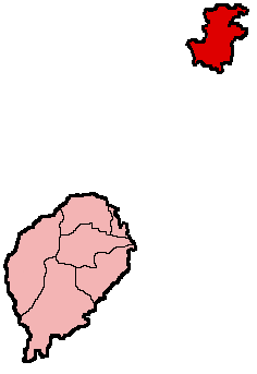
mapsize =150px
subdivision_type1=Province/island
subdivision_name1=Príncipe
seat=Santo António
area_blank1_km2 =136
area_blank1_title = Pagué
population_total=5,966
population_density_km2=43.87
centre=Santo Antonio
elevation_max_m =948
phonenumber=19x-xxxx
latd=14.91667/14°55'
longd=23.51667/23°31'
ISO 3166-2=ST-07Pagué is the single district of Príncipe Province. Out of the seven districts that make up the
equatorial Atlantic islands ofSão Tomé and Príncipe , its population is the smallest with approximately 5,400 residents. Its capital, Santo António (pop: 1,156), is also the provincial capital of Príncipe. This district as well as the province includes several small uninhabited islands around the island of Príncipe. TheObo National Park covers the part of the area.District Population History
*1940 3,124 (5.2% of the national population)
*1950 4,402 (7.3% of the national population)
*1960 4,544 (7.1% of the national population)
*1970 4,593 (6.2% of the national population)
*1981 5,255 (5.4% of the national population)
*1991 5,471 (4.7% of the national population)
*2001 5,966 (4.3% of the national population)Persons
*
Damião Vaz d'Almeida , a former prime minister of São Tomé and Príncipe and a former president of the regional government of PríncipeOther
Pagué has a school or collegiates ("colegio"), a lyceum (middle schools), churches, beaches, a port and a few squares ("
praça s"). Much of the area are underdeveloped and is the least developed in the two islands. Much of its roads are unpaved.
Wikimedia Foundation. 2010.