- Innaloo, Western Australia
-
Innaloo
Perth, Western Australia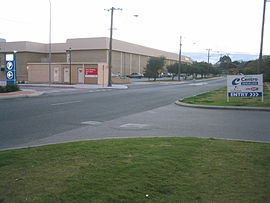
Oswald Street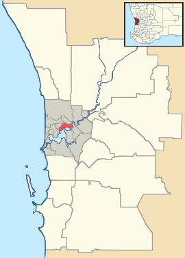
 Innaloo
Population: 6,470 (2006 census)[1] Established: 1950s Postcode: 6018 Area: 3.0 km² (1.2 sq mi) Location: 9 km (6 mi) NNE of Perth LGA: City of Stirling State District: Scarborough Federal Division: Stirling Suburbs around Innaloo: Karrinyup Gwelup Stirling Doubleview Innaloo Osborne Park Wembley Downs Woodlands Herdsman Coordinates: 31°53′38″S 115°47′28″E / 31.894°S 115.791°E
Innaloo is a suburb of Perth, the capital city of Western Australia, and it is located 9 km from Perth's central business district. Its Local Government Area is the City of Stirling.
Innaloo is a more established residential suburb that is also home to the Westfield Innaloo and Westfield Innaloo Megacentre shopping centres, and is adjacent to Perth's largest cinema complex, the 18-cinema Greater Union Megaplex Innaloo
Contents
History
Innaloo was originally named "Njookenbooroo", a local Noongar Aboriginal name for a nearby swamp. This name was too difficult to pronounce or spell, and in 1927, the local progress association asked welfare worker and anthropologist Daisy Bates to compile a list of words and names. The name of an Aboriginal woman from Dongara was chosen for the area.[2] It is much beloved of comedians making fun of place names, along with the suburb of Upper Swan. However, all attempts at changing the name from Innaloo have so far failed.
From settlement to suburb
Land near Innaloo was first granted to Thomas Mews in 1831. In 1898, Town Properties of WA subdivided the lands around Njookenbooroo Swamp for sale as market gardens and drained the swamp into Herdsman Lake over the following years, digging channels through the area to facilitate agriculture. They offered rent-free lease of the lots with an option to later purchase at £100 per hectare if the occupants cleared them and brought them into production. The area between Hertha Road, Oswald Street and King Edward Road and Herdsman Lake was gazetted as the Njookenbooroo Drainage District, and by 1912, local market gardeners were turning off 25 tonnes of produce each week, even considering the vagaries of the weather and occasional pests.[3] The Njookenbooroo School on Odin Road (then called Government Road), linked to the city by a plank road, was built in 1915. Although subdivision for southern Innaloo was approved in 1916, by the 1920s only ten houses had been built, with the majority of the land used for grazing.[4] Residential development accelerated during World War II, and in the 1950s, Metro-Goldwyn-Mayer (MGM) built a drive-in cinema in nearby Liege Street.
Development of modern Innaloo
Development of the suburb was essentially complete by 1970, and its status increased due to its proximity to Scarborough Beach, and the light industrial and commercial centre of Osborne Park, the building of the Nookenburra Hotel (1962) and shopping centre (1967) and the nearby civic centre in Hertha Road (1966). The Mitchell Freeway was extended to Hutton Street in 1981 and to Karrinyup Road in 1984, and the shopping centre also hosted the region's main bus station until the construction of Stirling bus/train interchange about a kilometre away in 1992. In 1999, Ellen Stirling Boulevard, named after the wife of the first governor of Western Australia, was constructed on land purchased from the last market gardeners in the area to replace the increasingly hazardous Oswald Street as the main through link between the freeway and the shopping areas.
Geography
Innaloo is bounded by Karrinyup Road to the north, Huntriss Road to the west, Scarborough Beach Road to the south and Mitchell Freeway and the future line of Stephenson Avenue to the east. The majority of the suburb is residential, apart from the shopping areas in the south-east, several small parks and an undeveloped portion to the east of Ellen Stirling Boulevard.[5] Some of the undeveloped area next to Stirling station has been developed as a commercial area centred around a new Ikea store.
At the ABS 2006 census, Innaloo had a mostly middle-income population of 6,470 people.[1] Most homes are single detached homes of timber-frame construction built around World War II, but some duplexes and recently built units also exist.[4] A number of elderly homes including Geneff Village, named for Sorrento businessman and philanthropist George Geneff (who also built the Nookenburra Hotel), are located within the suburb.
Facilities
Main article: Westfield InnalooInnaloo contains the Westfield Innaloo shopping centre. Next to Westfield Innaloo on Ellen Stirling Boulevard is the Westfield Innaloo Megacentre (acquired from Centro in August 2006), which contains 20 stores and a Progressive Supa IGA (formerly Action). Across Scarborough Beach Road is the Greater Union Megaplex. The northern part of the suburb also contains a small local shopping area in Morris Place. Opposite the Megacenter, an IKEA has been constructed, replacing the smaller store a kilometre away in the adjoining suburb of Osborne Park.
Innaloo's southern border with Woodlands hosts Perth's largest cinema complex, the 18-cinema Greater Union Megaplex Innaloo, which contains Gold Class cinemas, as well as an arcade with numerous restaurants and dining speciality outlets, including Sizzler, Han's Cafe, Bollywood Resto Bar and Retro Betty's, and a game centre (centred on Timezone). It started off life as an MGM drive-in in the 1950s, then was rebuilt by Greater Union in 1990 with 8 screens, then expanded to a Megaplex - the first in Western Australia - in 1996.
Transport
Innaloo is served by bus links to Stirling train station on the Joondalup Line, including the 410, 411, 412, 421, 426 and the 98/99 CircleRoute, and the 423 and 425 along the Karrinyup Road boundary.[6] Additionally, the 400 and 408 services link Scarborough and the Glendalough railway station along Innaloo's southern boundary. Innaloo's location next to the rail line makes it one of the best served areas for public transport in Perth.
Prior to the construction of the Stirling railway station as part of the Northern Suburbs Transit System, a possible deviation of the rail alignment was considered to directly service the suburb and it's shopping district including Westfield Innaloo.[7] However, this idea was rejected by both the project and the public at large due to the significant cost, lack of identifiable benefits, and environmental impact grounds.[7]
Politics
Innaloo is a mixed-wealth suburb with many "mortgage belt" families, as well as many elderly voters. The Yuluma booth is among the northern suburbs' few genuinely marginal booths at federal level. However, they strongly support the Australian Labor Party at state elections.
2004 Federal Election
Source: AEC [1]Liberal 45.7% Labor 40.3% Greens 7.65% CDP 2.31% One Nation 1.57% 2001 Federal Election
Source: AEC [2]Labor 41.3% Liberal 39.2% Greens 7.34% Democrats 5.74% One Nation 3.72% 1998 Federal Election
Source: AECLabor 42.6% Liberal 36.8% One Nation 8.27% Greens 6.12% Democrats 4.46% 2005 State Election
Source: WAEC [3] [4]Labor 42.5% Liberal 31.0% Independent 11.8% Greens 9.79% CDP 4.91% 2001 State Election
Source: WAECLabor 44.7% Liberal 31.9% Independent 7.04% Greens 6.81% One Nation 5.70% 1996 State Election
Source: WAECLabor 41.7% Liberal 40.9% Greens 6.94% Democrats 6.84% Independent 3.63% References
- ^ a b Australian Bureau of Statistics (25 October 2007). "Innaloo (State Suburb)". 2006 Census QuickStats. http://www.censusdata.abs.gov.au/ABSNavigation/prenav/LocationSearch?collection=Census&period=2006&areacode=SSC51676&producttype=QuickStats&breadcrumb=PL&action=401. Retrieved 2008-10-05.
- ^ Western Australian Land Information Authority. "History of metropolitan suburb names". http://www.landgate.wa.gov.au/corporate.nsf/web/History+of+metropolitan+suburb+names. Retrieved 2007-01-17.
- ^ Cooper, W.S.; G. McDonald (1999). Diversity's Challenge: A History of the City of Stirling. City of Stirling. pp. 155–157.
- ^ a b City of Stirling. "Suburbs - Innaloo". http://www.stirling.wa.gov.au/home/council/Suburbs/Innaloo.htm. Retrieved 2006-09-29.
- ^ 2007 StreetSmart directory, Department of Lands and Surveys, Perth.
- ^ Transperth website, accessed 2006-11-18.
- ^ a b Northern Suburbs Transit System: Transport Study Report. Perth, Western Australia: Urban Rail Electrification Steering Committee, Government of Western Australia. 1989. Pg. 4, Accessed at J S Battye Library, Perth
Further reading
- Thomas, Maud (ed.) (1989). Along the plank road : through Njookenbooroo to Scarborough Beach. City of Stirling. ISBN 0-9598819-5-6.
External links
Suburbs of the City of Stirling | Perth | Western Australia Coastal Carine · Churchlands · Doubleview · Gwelup · Innaloo · Karrinyup · North Beach · Scarborough · Trigg · Watermans Bay · Wembley Downs¹ · Woodlands

Central Balcatta · Balga · Dianella · Glendalough · Hamersley · Herdsman · Joondanna · Mirrabooka · Nollamara · Osborne Park · Stirling · Tuart Hill · Westminster · Yokine
South Eastern ¹ Suburb shared with other Local Government AreasCategories:- Suburbs of Perth, Western Australia


Wikimedia Foundation. 2010.