- Croydon Canal
-
Croydon Canal A short section of the canal remains in Betts Park, Anerley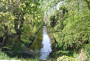
Date of act 1801 Date of first use 1809 Date closed 1836 Start point Croydon End point New Cross Connects to Grand Surrey Canal Locks 28 Status mostly destroyed The Croydon Canal Legend

Grand Surrey Canal 
1 lock 2 lock 
bridge at New Cross Gate Station 3 lock 
4-10 New Cross locks (7) Brockley Cross bridge 11-26 Honor Oak (17) 
(Lock 26 was a staircase of 2) 
Dacres Wood (Nature reserve) 


Sydenham Resr and feeder 
Penge Wharf Anerley Tea Rooms section Betts Park concrete trough Norwood Resr and feeder Norwood Wharf 
steam pumping station 27-28 Croydon Common locks (2) 
dock 
West Croydon basin The Croydon Canal ran 9.25 miles (15 km) from Croydon, via Forest Hill, to the Grand Surrey Canal at New Cross in south London, England. It opened in 1809, and closed in 1836, making it the first canal to be formally abandoned by an Act of Parliament.
Contents
History
Authorised by an Act of Parliament in 1801, the canal was originally intended to extend northwards to Rotherhithe, but the simultaneous construction of the Grand Surrey Canal provided a convenient access route. It was 9.25 miles (15 km) long, and opened on 22 October 1809.[1]
The Croydon Canal linked to the Croydon Merstham and Godstone Railway (itself connected to the Surrey Iron Railway), enabling the canal to be used to transport stone and lime from workings at Merstham. The canal was never extended further south-west, as was initially intended, to reach Epsom.
The canal was originally planned with two inclined planes but in the end 28 locks, arranged in two flights, were used instead. To keep the canal supplied with water a reservoir was constructed at Sydenham, with another at South Norwood; this still exists as South Norwood Lake in a public park.
The canal was built 34 feet (10 m) wide. It had a maximum depth of 5 feet (1.5 m). By 1811 22 barges plied the canal. The barges were 60 feet (18 m) long and 9 feet (2.7 m) wide and could carry about 30 tons. The main cargo was timber.
After the initial flights of locks, most of the canal followed the 161 ft (49.1m) contour. [2]
The final two locks at Croydon Common raised the level of the canal to the 174 ft (53m) contour, and because there was no natural source of water a steam pumping station was built at the foot of the locks to pump water up to the summit pound.[3]
The canal was never a success and closed in 1836.[1] It was the first canal to be formally abandoned by an Act of Parliament. Much of the alignment was used by the London & Croydon Railway Company (to whom the canal had been sold for £40,250[1]) for part of the railway route that today links London Bridge station and West Croydon station, which stands on the site of the old canal basin.
Today
 Anerley, 1860. This part of the canal remained, after closure, for pleasure boating.
Although the canal closed in 1836, certain sections were retained for leisure use, and some remained in water for a considerable time. The section at Betts Park in Anerley was used as a boating lake, and the area was called Anerley Tea Rooms. The canal was turned into a concrete trough in 1934, and can be seen at the northern corner of Betts Park. Another section exists as a long curved pond in a small nature reserve in Dacres Road, Forest Hill. This was considered for redevelopment in 1989, but research by Lewisham Council resulted in its identity being confirmed, and it now forms an attractive wetland, having been returned to its former width.[4][5] There is a high pavement in David's Road, Forest Hill, which is thought to be part of the towpath. Part of the wall below the path has been rebuilt with murals depicting transport in Forest Hill.[6]
Points of interest
Point Coordinates
(Links to map resources)OS Grid Ref Notes Lock 10 51°28′17″N 0°02′11″W / 51.4715°N 0.0363°W TQ364765 New Cross Bottom of Honor Oak flight 51°27′52″N 0°02′14″W / 51.4645°N 0.0372°W TQ364757 Brockley Top of Honor Oak flight 51°26′59″N 0°02′54″W / 51.4498°N 0.0482°W TQ357741 Honor Oak David's Road 51°26′25″N 0°03′18″W / 51.4403°N 0.0549°W TQ352730 Raised towpath Dacres Wood 51°25′55″N 0°03′08″W / 51.4320°N 0.0523°W TQ354721 Nature reserve Penge Wharf 51°25′07″N 0°03′35″W / 51.4185°N 0.0598°W TQ350706 Penge Anerley 51°24′52″N 0°03′58″W / 51.4144°N 0.0661°W TQ345701 Tea rooms Betts Park 51°24′35″N 0°03′58″W / 51.4096°N 0.0660°W TQ346696 Concrete trough South Norwood lake 51°24′26″N 0°04′27″W / 51.4071°N 0.0742°W TQ340693 Feeder reservoir Croydon Common Locks 51°23′12″N 0°05′14″W / 51.3866°N 0.0871°W TQ332670 2 locks West Croydon Basin 51°22′44″N 0°06′08″W / 51.3789°N 0.1022°W TQ321661 Terminus See also
Bibliography
Hadfield, Charles (1969). The Canals of South and South East England. David and Charles. ISBN 0-7153-4693-8.
References
- ^ a b c Hadfield 1969, p. 374
- ^ "Croydon: Honor Oak". London Canals. http://www.londoncanals.co.uk/croydon/croy07.html.
- ^ "Croydon: Norwood". London Canals. http://www.londoncanals.co.uk/croydon/croy17.html.
- ^ "Croydon: Dacres Wood". London Canals. http://www.londoncanals.co.uk/croydon/croy12.html.
- ^ "Conservation: Dacres Wood". Lewisham Council. http://www.lewisham.gov.uk/inmyarea/openspaces/nature-reserves/dacres-wood/Pages/default.aspx.
- ^ "Croydon: Davids Road". London Canals. http://www.londoncanals.co.uk/croydon/croy09.html.
Categories:- Canals in London
- Transport in Croydon
- History of Croydon
- History of transport in London


Wikimedia Foundation. 2010.