- 1980 eruption of Mount St. Helens
-
1980 eruption of Mount St. Helens 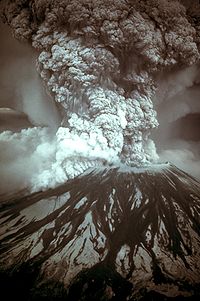
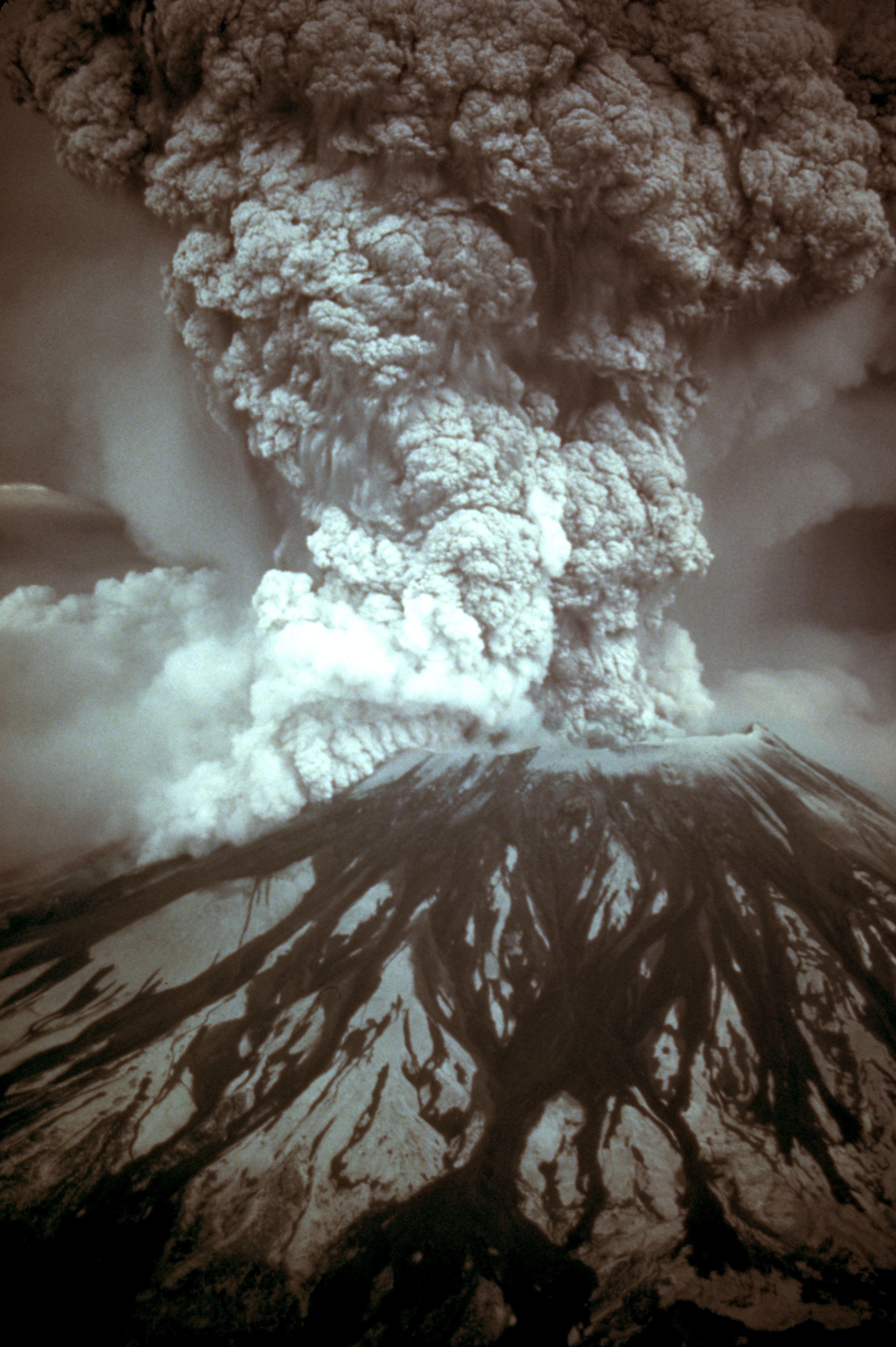
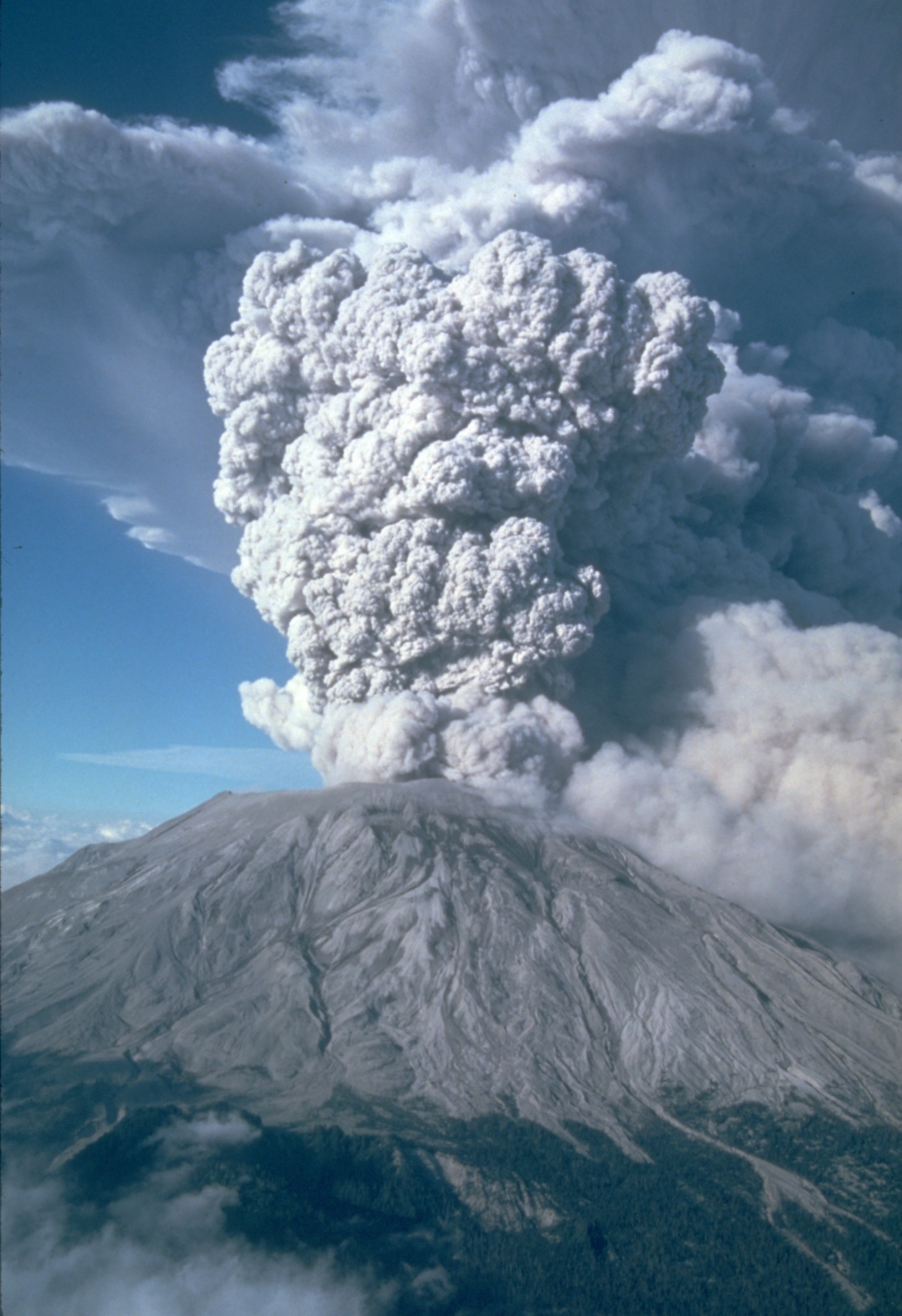
Photograph of the eruption column, May 18, 1980Volcano Mount St. Helens Date Sunday, May 18, 1980 Type Plinian Location Skamania County, Washington
46°12′1″N 122°11′12″W / 46.20028°N 122.18667°WVEI 5 Impact 57 deaths, $1.1 billion in property damage; caused a partial collapse of the volcano's flank, deposited ash in 11 states 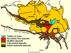
Map of eruption deposits The 1980 eruption of Mount St. Helens, a stratovolcano located in Washington state, in the United States, was a major volcanic eruption. The eruption (which was a VEI 5 event) was the only significant one to occur in the contiguous 48 U.S. states since the 1915 eruption of Lassen Peak in California.[1] The eruption was preceded by a two-month series of earthquakes and steam-venting episodes, caused by an injection of magma at shallow depth below the volcano that created a huge bulge and a fracture system on Mount St. Helens' north slope.
USGS scientists convinced the authorities to close Mount St. Helens to the general public and to maintain the closure in spite of pressure to re-open it; their work saved thousands of lives. An earthquake at 8:32:17 a.m. PDT (UTC−7) on Sunday, May 18, 1980, caused the entire weakened north face to slide away, suddenly exposing the partly molten, gas- and steam-rich rock in the volcano to lower pressure. The rock responded by exploding a hot mix of lava and pulverized older rock toward Spirit Lake so fast that it overtook the avalanching north face.
An eruption column rose 80,000 feet (24,400 m) into the atmosphere and deposited ash in 11 U.S. states.[2] At the same time, snow, ice and several entire glaciers on the volcano melted, forming a series of large lahars (volcanic mudslides) that reached as far as the Columbia River, nearly fifty miles (eighty kilometers) to the southwest. Less severe outbursts continued into the next day only to be followed by other large but not as destructive eruptions later in 1980.
57 people[3] (including innkeeper Harry R. Truman, photographer Reid Blackburn and geologist David A. Johnston) and thousands of animals were killed. Hundreds of square miles were reduced to wasteland, causing over a billion U.S. dollars in damage ($2.74 billion in 2007 dollars[4]), and Mount St. Helens was left with a crater on its north side. At the time of the eruption, the summit of the volcano was owned by the Burlington Northern Railroad, but afterward the land passed to the United States Forest Service.[5] The area was later preserved, as it was, in the Mount St. Helens National Volcanic Monument.
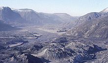
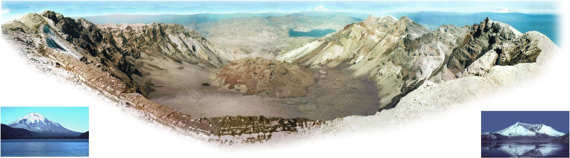
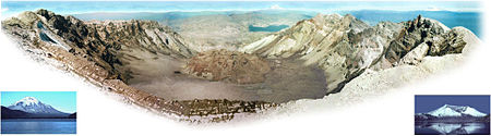 Mount St. Helens from Monitor Ridge showing the cone of devastation, the huge crater open to the north, the post-eruption lava dome inside and Crater Glacier surrounding the lava dome. The small photo on the left was taken from Spirit Lake before the eruption and the small photo on the right was taken after the eruption from approximately the same place. Spirit Lake can also be seen in the larger image, as well as two other Cascade volcanoes.
Contents
Buildup to the eruption
Mount. St. Helens remained dormant from its last period of activity in the 1840s and 1850s until March 1980.[6] Several small earthquakes beginning as early as March 15, 1980, indicated that magma may have been moving below the volcano.[7] Then on March 18 at 3:45 p.m. Pacific Standard Time (all times will be in PST or PDT), a shallow Richter magnitude 4.2 earthquake (the initial reading was 4.1), centered below the volcano's north flank,[7] signaled the volcano's violent return from 123 years of hibernation.[8] A gradually building earthquake swarm saturated area seismographs and started to climax at about noon on March 25, reaching peak levels in the next two days, including an earthquake registering 5.1 on the Richter scale.[9] A total of 174 shocks of magnitude 2.6 or greater were recorded during those two days.[10]
 USGS photo showing a pre-avalanche eruption on April 10.
Shocks of magnitude 3.2 or greater occurred at a slightly increasing rate during April and May with five earthquakes of magnitude 4 or above per day in early April, and 8 per day the week before May 18.[8] Initially there was no direct sign of eruption, but small earthquake-induced avalanches of snow and ice were reported from aerial observations.
At 12:36 p.m. on March 27, at least one but possibly two nearly simultaneous phreatic eruptions (exploding groundwater-derived steam) ejected and smashed rock from within the old summit crater, excavating a new crater 250 feet (76 m) wide[8] and sending an ash column about 7,000 feet (2,100 m) into the air.[10] By this date, a 16,000-foot (4,900 m) long, east-trending fracture system had also developed across the summit area.[11] This was followed by more earthquake swarms and a series of steam explosions that sent ash 10,000 to 11,000 feet (3,000 to 3,400 m) above their vent.[8] Most of this ash fell within 3 to 12 miles (5 to 20 km) from its vent, but some was carried as far as 150 miles (240 km) south to Bend, Oregon, and 285 miles (460 km) east to Spokane, Washington.[12]
 Photo showing the cryptodome on April 27.
A second, new crater and a blue flame was observed on March 29.[12][13] The flame was visibly emitted from both craters and was probably created by burning gases. Static electricity generated from ash clouds rolling down the volcano sent out lightning bolts that were up to two miles (3 km) long.[12] Ninety-three separate outbursts were reported on March 30,[12] and increasingly strong harmonic tremors were first detected on April 1, alarming geologists and prompting Governor Dixy Lee Ray to declare a state of emergency on April 3.[14] Governor Ray issued an executive order on April 30 creating a "red zone" around the volcano; anyone caught in this zone without a pass faced a $500 fine or six months in prison.[15] This excluded many cabin owners from visiting their property.
By April 7 the combined crater was 1,700 feet (520 m) long, 1,200 feet (365 m) wide and 500 feet (150 m) deep.[16] A USGS team determined in the last week of April that a 1.5-mile (2.4 km) diameter section of St. Helens' north face was displaced out at least 270 feet (82 m).[11] For the rest of April and early May this bulge grew 5 to 6 ft (1.5 to 1.8 m) per day, and by mid-May it extended more than 400 feet (120 m) north.[11] As the bulge moved northward, the summit area behind it progressively sank, forming a complex, down-dropped block called a graben. Geologists announced on April 30 that sliding of the bulge area was the greatest immediate danger and that such a landslide might spark an eruption. These changes in the volcano's shape were related to the overall deformation that increased the volume of the volcano by 0.03 cubic miles (0.1 km³) by mid-May.[17] This volume increase presumably corresponded to the volume of magma that pushed into the volcano and deformed its surface. Because the intruded magma remained below ground and was not directly visible, it was called a cryptodome, in contrast to a true lava dome exposed at the surface.
On May 7, eruptions similar to those in March and April resumed, and over the next days the bulge approached its maximum size.[18] All activity had been confined to the 350-year-old summit dome and did not involve any new magma. A total of about 10,000 earthquakes were recorded prior to the May 18 event, with most concentrated in a small zone less than 1.6 miles (2.6 km) directly below the bulge.[17] Visible eruptions ceased on May 16, reducing public interest and consequently the number of spectators in the area.[19] Mounting public pressure then forced officials to allow 50 carloads of property owners to enter the danger zone on May 17 to gather whatever property they could carry.[19] Another trip was scheduled for 10 a.m. the next day.[19] Since that was Sunday, more than 300 loggers would not be working in the area. By the time of the climactic eruption, dacite magma intruding into the volcano had forced the north flank outward nearly 500 feet (150 m) and heated the volcano's groundwater system, causing many steam-driven explosions (phreatic eruptions).
North face slides away
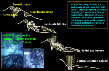 Sequence of events on May 18.
At 7 a.m. on May 18, USGS volcanologist David A. Johnston, who had Saturday night duty at an observation post about 6 miles (10 km) north of the volcano, radioed in the results of some laser-beam measurements he had made moments earlier.[5] Mount St. Helens' activity that day did not show any change from the pattern of the preceding month. The rate of bulge movement, sulfur dioxide emission, and ground temperature readings did not reveal any unusual changes that might have indicated a catastrophic eruption.
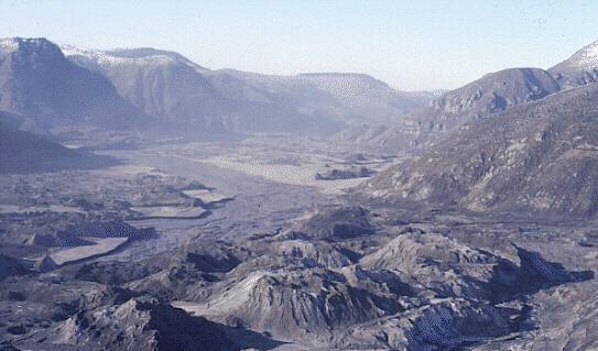
 North Fork Toutle River valley filled with landslide deposits.
Suddenly, at 8:32 a.m., a magnitude 5.1 earthquake centred directly below the north slope triggered that part of the volcano to slide,[20] approximately 7–20 seconds (about 10 seconds seems most reasonable) after the shock.[5] The landslide, one of the largest in recorded history, travelled at 110 to 155 miles per hour (175 to 250 km/h) and moved across Spirit Lake's west arm. Part of it hit a 1,150-foot (350 m) high ridge about 6 miles (10 km) north.[5] Some of the slide spilled over the ridge, but most of it moved 13 miles (21 km) down the North Fork Toutle River, filling its valley up to 600 feet (180 m) deep with avalanche debris.[20] An area of about 24 square miles (62 km²) was covered, and the total volume of the deposit was about 0.7 cubic miles (2.9 km³).[5]
Scientists were able to reconstruct the landslide due to a series of rapid photographs by Gary Rosenquist, who was camping 11 miles (18 km) away from the blast.[5] Rosenquist, his party, and his photographs survived because the blast was deflected by local topography 1 mile (1.6 km) short of his location.[21]
Most of St. Helens' former north side became a rubble deposit 17 miles (27 km) long, averaging 150 feet (46 m) thick; the slide was thickest at one mile (1.6 km) below Spirit Lake and thinnest at its western margin.[5] Thousands of trees were torn from the surrounding hillside after the lake was sloshed 800 ft (250 m) up the hillside. All the water in Spirit Lake was temporarily displaced by the landslide, sending 600-foot (180 m) high waves crashing into a ridge north of the lake,[22] adding 295 feet (90 m) of new avalanche debris above the old lakebed, and raising its surface level by about 200 feet (60 m).[5] As the water moved back into its basin, it pulled with it thousands of trees felled by a super-heated wall of volcanic gas and searing ash and rock that overtook the landslide seconds before.
Pyroclastic flows
Initial lateral blast
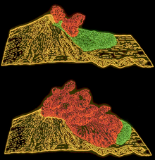 Computer graphic showing the May 18 landslide (green) being overtaken by the initial pyroclastic flow (red).
The landslide exposed the dacite magma in St. Helens' neck to much lower pressure causing the gas-charged, partially molten rock and high-pressure steam above it to explode a few seconds after the slide started. Explosions burst through the trailing part of the landslide, blasting rock debris northward. The resulting blast laterally directed the pyroclastic flow of very hot volcanic gases, ash and pumice formed from new lava, while pulverized old rock hugged the ground, initially moving at 220 mph (350 km/h) but quickly accelerating to 670 mph (1080 km/h) (it may have briefly passed the speed of sound).[5][20]
Pyroclastic flow material passed over the moving avalanche and spread outward, devastating a fan-shaped area 23 miles (37 km) across and 19 miles (30 km) long.[20] In all, about 230 square miles (600 km²) of forest were knocked down,[20] and extreme heat killed trees miles beyond the blow-down zone. At its vent the lateral blast probably did not last longer than about 30 seconds, but the northward radiating and expanding blast cloud continued for about another minute.
Superheated flow material flashed water in Spirit Lake and North Fork Toutle River to steam, creating a larger, secondary explosion that was heard as far away as British Columbia,[23] Montana, Idaho, and Northern California. Yet many areas closer to the eruption (Portland, Oregon, for example) did not hear the blast. This so-called "quiet zone" extended radially a few tens of miles from the volcano and was created by the complex response of the eruption's sound waves to differences in temperature and air motion of the atmospheric layers and, to a lesser extent, local topography.[5]
Later studies indicated that one-third of the 0.045 cubic miles (188,000,000 m³) of material in the flow was new lava, and the rest was fragmented, older rock.[23]
Lateral blast result
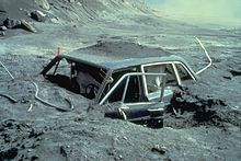 Photographer Reid Blackburn's car after the eruption.
Everyone in the quiet zone could see the huge ash cloud that was sent skyward from St. Helens' northern foot. The near-supersonic lateral blast, loaded with volcanic debris, caused devastation as far as 19 miles (30 km) from the volcano. The area affected by the blast can be subdivided into three roughly concentric zones:[5]
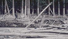
- Direct blast zone, the innermost zone, averaged about 8 miles (13 km) in radius, an area in which virtually everything, natural or artificial, was obliterated or carried away.[5] For this reason, this zone also has been called the "tree-removal zone." The flow of the material carried by the blast was not deflected by topographic features in this zone.
- Channelized blast zone, an intermediate zone, extended out to distances as far as 19 miles (30 km) from the volcano, an area in which the flow flattened everything in its path and was channeled to some extent by topography.[5] In this zone, the force and direction of the blast are strikingly demonstrated by the parallel alignment of toppled large trees, broken off at the base of the trunk as if they were blades of grass mown by a scythe. This zone was also known as the "tree-down zone."
- Seared zone, also called the "standing dead" zone, the outermost fringe of the impacted area, a zone in which trees remained standing but were singed brown by the hot gases of the blast.[5]
By the time this pyroclastic flow hit its first human victims, it was still as hot as 360 °C (680 °F) and filled with suffocating gas and flying angular material.[23] Most of the 57 people known to have died in that day's eruption succumbed to asphyxiation while several died from burns.[5] Lodge owner Harry R. Truman was buried under hundreds of feet of avalanche material. Volcanologist David A. Johnston was one of those killed, as was Reid Blackburn, a National Geographic photographer.
Later flows
Subsequent outpourings of pyroclastic material from the breach left by the landslide consisted mainly of new magmatic debris rather than fragments of preexisting volcanic rocks. The resulting deposits formed a fan-like pattern of overlapping sheets, tongues, and lobes. At least 17 separate pyroclastic flows occurred during the May 18 eruption, and their aggregate volume was about 0.05 cubic miles (208,000,000 m³).[5]
The flow deposits were still at about 300 °C to 420 °C (570 °F to 785 °F) two weeks after they erupted.[5] Secondary steam-blast eruptions fed by this heat created pits on the northern margin of the pyroclastic-flow deposits, at the south shore of Spirit Lake, and along the upper part of the North Fork Toutle River. These steam-blast explosions continued sporadically for weeks or months after the emplacement of pyroclastic flows, and at least one occurred a year later, on May 16, 1981.[5]
Ash column grows
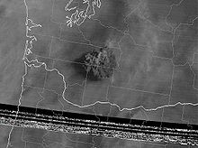 Ash cloud from Mt St Helens as captured by GOES-3 at 1545 UTC.
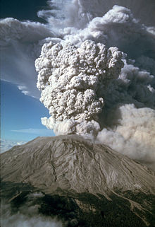
As the avalanche and initial pyroclastic flow were still advancing, a huge ash column grew to a height of 12 miles (19 km) above the expanding crater in less than 10 minutes and spread tephra into the stratosphere for 10 straight hours.[23] Near the volcano, the swirling ash particles in the atmosphere generated lightning, which in turn started many forest fires. During this time, parts of the mushroom-shaped ash-cloud column collapsed, and fell back upon the earth. This fallout, mixed with magma, mud, and steam, sent additional pyroclastic flows speeding down St. Helens' flanks. Later, slower flows came directly from the new north-facing crater and consisted of glowing pumice bombs and very hot pumiceous ash. Some of these hot flows covered ice or water which flashed to steam, creating craters up to 65 feet (20 m) in diameter and sending ash as much as 6,500 feet (1980 m) into the air.[24]
Strong high-altitude wind carried much of this material east-northeasterly from the volcano at an average speed of about 60 mph (100 km/h). By 9:45 a.m. it had reached Yakima, Washington, 90 miles (145 km) away, and by 11:45 a.m. it was over Spokane, Washington.[5] A total of 4 to 5 inches (100 to 130 mm) of ash fell on Yakima, and areas as far east as Spokane were plunged into darkness by noon where visibility was reduced to 10 feet (3 m) and half an inch (13 mm) of ash fell.[23] Continuing east, St. Helens' ash fell in the western part of Yellowstone National Park by 10:15 p.m. and was seen on the ground in Denver, Colorado, the next day.[23] In time ash fall from this eruption was reported as far away as Minnesota and Oklahoma, and some of the ash drifted around the globe within about 2 weeks.
During the nine hours of vigorous eruptive activity, about 540 million tons of ash fell over an area of more than 22,000 square miles (60,000 km²).[5] The total volume of the ash before its compaction by rainfall was about 0.3 cubic miles (1.3 km³).[5] The volume of the uncompacted ash is equivalent to about 0.05 mile³ (208,000,000 m³) of solid rock, or about 7% of the amount of material that slid off in the debris avalanche.[5] By around 5:30 p.m. on May 18, the vertical ash column declined in stature, but less severe outbursts continued through the next several days.[25]
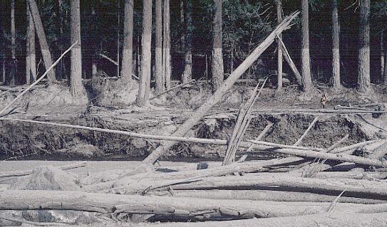
Mudslides flow downstream
 Mudline next to Muddy River from the 1980 lahars.
The hot, exploding material also broke apart and melted nearly all of the mountain's glaciers along with most of the overlying snow. As in many previous St. Helens' eruptions, this created huge lahars (volcanic mudflows) and muddy floods that affected three of the four stream drainage systems on the mountain,[24] and which started to move as early as 8:50 a.m.[22] Lahars travelled as fast as 90 mph (145 km/h) while still high on the volcano but progressively slowed to about 3 mph (5 km/h) on the flatter and wider parts of rivers.[5] Mudflows from the southern and eastern flanks had the consistency of wet concrete as they raced down Muddy River, Pine Creek and Smith Creek to their confluence at the Lewis River. Bridges were taken out at the mouth of Pine Creek and the head of Swift Reservoir, which rose 2.6 feet (0.8 m)[24] by noon to accommodate the nearly 18 million cubic yards (13 million m³) of additional water, mud and debris.[5]
Glacier and snow melt mixed with tephra on the volcano's northeast slope to create much larger lahars. These mudflows traveled down the north and south forks of the Toutle River and joined at the confluence of the Toutle forks and the Cowlitz River near Castle Rock, Washington, at 1:00 p.m. Ninety minutes after the eruption, the first mudflow had moved 27 river miles (43 km) upstream where observers at Weyerhaeuser's Camp Baker saw a 12-foot (3.7 m) high wall of muddy water and debris pass.[22] Near the confluence of the Toutle's north and south forks at Silver Lake, a record flood stage of 23.5 feet (7.2 m) was recorded.[22]
A large but slower-moving mudflow with a mortar-like consistency was mobilized in early afternoon at the head of the Toutle River north fork. By 2:30 p.m. the massive mudflow had destroyed Camp Baker,[22] and in the following hours seven bridges were carried away. Part of the flow backed up for 2.5 miles (4 km) soon after entering the Cowlitz River, but most continued downstream. After traveling 17 miles (27 km) further, an estimated 3.9 million cubic yards (3.0 million m³) of material were injected into the Columbia River, reducing the river's depth by 25 feet (7.6 m) for a four-mile (6 km) stretch.[22] The resulting 13-foot (4 m) river depth temporarily closed the busy channel to ocean-going freighters, costing Portland, Oregon an estimated five million US dollars.[25] Ultimately more than 65 million cubic yards (50 million m³) of sediment were dumped along the lower Cowlitz and Columbia Rivers.[5]
Aftermath
Direct results
 Map showing 1980 eruption deposits.
The May 18, 1980, event was the most deadly and economically destructive volcanic eruption in the history of the United States.[5] 57 people were killed and 200 houses, 27 bridges, 15 miles (24 km) of railways and 185 miles (300 km) of highway were destroyed. U.S. President Jimmy Carter surveyed the damage and said it looked more desolate than a moonscape.[26][27] A film crew was dropped by helicopter on St. Helens on May 23 to document the destruction. Their compasses, however, spun in circles and they quickly became lost.[28] A second eruption occurred the next day (see below), but the crew survived and were rescued two days after that. The eruption ejected more than 1 cubic mile (4 km³) of material.[29] A quarter of that volume was fresh lava in the form of ash, pumice and volcanic bombs while the rest was fragmented, older rock.[29] The removal of the north side of the mountain (13% of the cone's volume) reduced St. Helens' height by about 1,313 feet (400 m) and left a crater 1 to 2 miles (2 to 3 km) wide and 2,100 feet (640 m) deep with its north end open in a huge breach.[29]
More than 4 billion board feet (14.6 km³) of timber was damaged or destroyed, mainly by the lateral blast.[5] At least 25% of the destroyed timber was salvaged after September 1980. Downwind of the volcano, in areas of thick ash accumulation, many agricultural crops, such as wheat, apples, potatoes and alfalfa, were destroyed. As many as 1,500 elk and 5,000 deer were killed, and an estimated 12 million[5] Chinook and Coho salmon fingerlings died when their hatcheries were destroyed. Another estimated 40,000 young salmon were lost when they swam through turbine blades of hydroelectric generators when reservoir levels were lowered along the Lewis River to accommodate possible mudflows and flood waters.[5]
In all, Mount St. Helens released 24 megatons of thermal energy, 7 of which was a direct result of the blast. This is equivalent to 1,600 times the size of the atomic bomb dropped on Hiroshima.[30]
Digging out
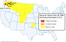 Map of ash distribution over the United States.
The ash fall created some temporary but major problems with transportation, sewage disposal, and water treatment systems. Visibility was greatly decreased during the ash fall, closing many highways and roads. Interstate 90 from Seattle to Spokane was closed for a week and a half.[5] Air travel was disrupted for a few days to 2 weeks as several airports in eastern Washington shut down because of ash accumulation and poor visibility. Over a thousand commercial flights were cancelled following airport closures.[5] Fine-grained, gritty ash caused substantial problems for internal-combustion engines and other mechanical and electrical equipment. The ash contaminated oil systems and clogged air filters, and scratched moving surfaces. Fine ash caused short circuits in electrical transformers, which in turn caused power blackouts.
Removing and disposing of the ash was a monumental task for some eastern Washington communities. State and federal agencies estimated that over 2.4 million cubic yards (1.8 million m³) of ash, equivalent to about 900,000 tons in weight, were removed from highways and airports in Washington.[5] The ash removal cost $2.2 million and took 10 weeks in Yakima.[5] The need to remove ash quickly from transport routes and civil works dictated the selection of some disposal sites. Some cities used old quarries and existing sanitary landfills; others created dump sites wherever expedient. To minimize wind reworking of ash dumps, the surfaces of some disposal sites were covered with topsoil and seeded with grass. In Portland, the mayor eventually threatened businesses with fines if they failed to remove the ash from their parking lots.[31]
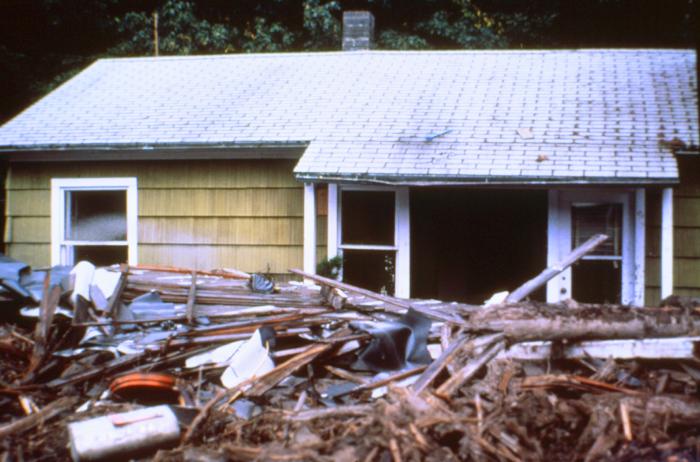
Cost
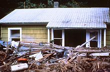 One of the 200 houses destroyed by the eruption.
Early estimates of the cost of the eruption ranged from US$2–3 billion.[5] A refined estimate of $1.1 billion ($2.74 billion in 2007 dollars[32]) was determined in a study by the International Trade Commission at the request of the United States Congress.[5] A supplemental appropriation of $951 million for disaster relief was voted by Congress, of which the largest share went to the Small Business Administration, U.S. Army Corps of Engineers and the Federal Emergency Management Agency.[5]
There were also indirect and intangible costs of the eruption. Unemployment in the immediate region of Mount St. Helens rose tenfold in the weeks immediately following the eruption, and then returned to nearly normal levels once timber salvaging and ash-cleanup operations were underway. Only a small percentage of residents left the region because of lost jobs owing to the eruption.[5] Several months after May 18, a few residents reported suffering stress and emotional problems, even though they had coped successfully during the crisis. Counties in the region requested funding for mental health programs to assist such people.[5]
Initial public reaction to the May 18 eruption dealt a nearly crippling blow to tourism, an important industry in Washington. Not only was tourism down in the Mount St. Helens–Gifford Pinchot National Forest area, but conventions, meetings and social gatherings also were cancelled or postponed at cities and resorts elsewhere in Washington and neighboring Oregon not affected by the eruption. The adverse effect on tourism and conventioneering, however, proved only temporary. Mount St. Helens, perhaps because of its reawakening, has regained its appeal for tourists. The United States Forest Service and the State of Washington opened visitor centers and provided access for people to view the volcano's devastation.[5]
Photographic and video record
The eruption of Mount St. Helens on May 18, 1980 was also one of the most well documented volcanic eruptions in recorded history. It is also one of very few major volcanic eruptions ever to be recorded on film at the moment of eruption. Early that morning at around 3AM local time, KOMO-TV news photographer Dave Crockett had left Seattle in a KOMO-TV news car bound for a lookout on the South Fork of the Toutle River where news crews had been stationed previously. At a campground 10 miles (16 km) away to the northeast, amateur photographer Gary Rosenquist as well as University of Washington graduate student Keith Ronnholm had been waiting. In the air directly above the volcano, geologists Keith and Dorothy Stoffel had chartered a Cessna aircraft from Yakima to do some photographic documentation of the summit bulge. To the west near the South Fork Toutle River, ham radio operators Ty and Mariana Kearney were stationed at a lookout point monitoring the activity for an emergency radio network.
At the moment of eruption, Gary Rosenquist was alerted to the volcano by a few members of his camping party and began firing off the first of a 24-frame sequence that clearly illustrated the landslide and beginning moments of the lateral blast and simultaneously doing so was Keith Ronnholm a few feet away. At the same time, Ty and Mariana Kearney were photographing it from the west side, as well as Keith and Dorothy Stoffel from the air. Arriving also at the moment of eruption was KOMO News photographer Dave Crockett. As the ash cloud loomed overhead and continued to spread out, a lahar coming down the South Fork Toutle River blocked his path of escape. He then got out of the car and began filming the eruption's ash column as well as the lightning and the lahars. As the cloud began darkening the sky he began a trek up a logging road and turned the camera on once again, this time narrating his video in what was recorded as a "death march." The video, of which 11 minutes is recorded in total darkness, was played out on newscasts worldwide. Crockett was later reprimanded for losing the station's news car.
Several other photographers perished during the blast. Reid Blackburn, photographer for The Columbian and monitor for the United States Geological Survey, was killed at his campsite, eight miles (13 km) from the volcano. He took several photos, but the film was destroyed by the pyroclastic flows. Robert Landsberg (spelled Landsburg in some accounts) succumbed to the eruption, but managed to secure his camera film; though damaged by the eruption, his photos—depicting the advancing pyroclastic surge—were processed and published in National Geographic magazine in 1981.
Later eruptions
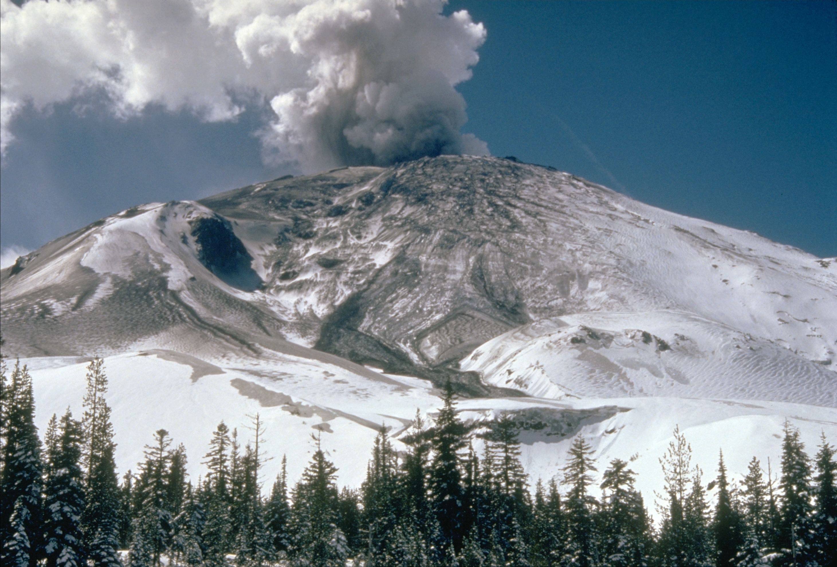
Further information: 2004–2008 volcanic activity of Mount St. HelensSt. Helens produced an additional five explosive eruptions between May and October 1980. Through early 1990, a total of at least 21 periods of eruptive activity had occurred. The volcano remains active, with smaller, dome-building eruptions continuing into 2008.
 Eruption on July 22, 1980.
An eruption occurred on May 25, 1980 at 2:30 a.m. that sent an ash column 9 miles (14 km) into the atmosphere.[29] The eruption was preceded by a sudden increase in earthquake activity and occurred during a rain storm. Erratic wind from the storm carried ash from the eruption to the south and west, lightly dusting large parts of western Washington and Oregon. Pyroclastic flows exited the northern breach and covered avalanche debris, lahars and other pyroclastic flows deposited by the May 18 eruption.[29]
At 7:05 p.m. on June 12, a plume of ash billowed 2.5 miles (4 km) above the volcano. At 9:09 p.m. a much stronger explosion sent an ash column about 10 miles (16 km) skyward.[33] This event caused the Portland area, previously spared by wind direction, to be thinly coated with ash in the middle of the annual Rose Festival.[34] A dacite dome then oozed into existence on the crater floor, growing to a height of 200 feet (60 m) and a width of 1,200 feet (370 m) within a week.[33]
A series of large explosions on July 22 broke more than a month of relative quiet. The July eruptive episode was preceded by several days of measurable expansion of the summit area, heightened earthquake activity, and changed emission rates of sulfur dioxide and carbon dioxide. The first hit at 5:14 p.m. as an ash column shot 10 miles (16 km) and was followed by a faster blast at 6:25 p.m. that pushed the ash column above its previous maximum height in just 7.5 minutes.[33] The final explosion started at 7:01 p.m. and continued for over two hours.[33] When the relatively small amount of ash settled over eastern Washington, the dome built in June was gone.[35]
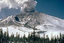
 The growing third dome on October 24, 1980.
Seismic activity and gas emission steadily increased in early August, and on August 7 at 4:26 p.m., an ash cloud slowly expanded 8 miles (13 km) into the sky.[35] Small pyroclastic flows were sent through the northern breach and weaker outpouring of ash rose from the crater. This continued until 10:32 p.m. when a second large blast sent ash high into the air.[35] A second dacite dome filled this vent a few days later.
Two months of repose were ended by an eruption lasting from October 16 to October 18. This event obliterated the second dome, sent ash 10 miles (16 km) in the air and created small, red-hot pyroclastic flows.[35] A third dome began to form within 30 minutes after the final explosion on October 18, and within a few days, it was about 900 feet (270 m) wide and 130 feet (40 m) high. In spite of the dome growth next to it, a new glacier formed rapidly inside the crater.
All of the post-1980 eruptions were quiet dome-building events, beginning with the December 27, 1980, to January 3, 1981, episode. By 1987 the third dome had grown to be more than 3,000 feet (900 m) wide and 800 feet (240 m) high.[35]
Further eruptions occurred over a few months during 1989–1991, and the mountain became active again in late 2004 building a new dome. This activity lasted until January 2008.
Summary table
Eruption summary
May 18, 1980, eruption of Mount St. Helens
Volcano Elevation of summit: Before eruption: 9,677 feet (2,950 m)
After eruption: 8,363 feet (2,549 m)
Total removed: 1,314 feet (401 m)Crater dimensions: East-West: 1.2 miles (1.9 km)
North-South: 1.8 miles (2.9 km)
Depth: 2,084 feet (635 m)Crater floor elevation: 6,279 feet (1,914 m) Eruption Date: May 18, 1980 Time of initial blast: 8:32 a.m. Pacific Daylight Time (UTC−7) Eruption trigger: A magnitude 5.1 earthquake about 1 mile (1.6 km) beneath the volcano Landslide and
debris avalancheArea covered: 23 square miles (60 km2) Volume:
(uncompacted deposits)0.67 mi³ (2.8 km³) Depth of deposit: Buried North Fork Toutle River to average depth of 150 feet (46 m) with a maximum depth of 600 feet (183 m) Velocity: 70 miles per hour (113 km/h) to 150 miles per hour (241 km/h) Lateral blast Area covered: 230 square miles (596 km2); reached 17 miles (27 km) northwest of the crater Volume of deposit:
(uncompacted deposits)0.046 mi³ (0.19 km³) Depth of deposit: From about 3 feet (1 m) at volcano to less than 1 inch (2.5 cm) at blast edge Velocity: At least 300 miles per hour (483 km/h) Temperature: As high as 660 °F (349 °C) Energy release: 24 megatons thermal energy (7 by blast, rest through release of heat) Trees blown down: 4 billion board feet (9.4 million m³) of timber (enough to build about 300,000 two-bedroom homes) Human fatalities: 57 Lahars Velocity: About 10 miles per hour (16 km/h) to 25 miles per hour (40 km/h) and over 50 miles per hour (80 km/h) on steep flanks of volcano Damaged: 27 bridges, nearly 200 homes. Blast and lahars destroyed more than 185 miles (298 km) of highways and roads and 15 miles (24 km) of railways. Effects on Cowlitz River: Reduced carrying capacity at flood stage at Castle Rock from 76,000 ft³/s (2,150 m³/s) to less than 15,000 ft³/s (225 m³/s) Effects on Columbia River: Reduced channel depth from 40 feet (12 m) to 14 feet (4 m); stranded 31 ships in upstream ports Eruption column
and cloudHeight: Reached about 80,000 feet (24,400 m) in less than 15 minutes Downwind extent: Spread across U.S. in 3 days; circled Earth in 15 days Volume of ash:
(based on uncompacted deposits)0.26 mi³ (1 km³) Ash fall area: Detectable amounts of ash covered 22,000 square miles (57,000 km2) Ash fall depth: 10 inches (25 cm) at 10 miles (16 km) downwind (ash and pumice)
1 inch (2.5 cm) at 60 miles (97 km) downwind
0.5 inches (1.3 cm) at 300 miles (482.8 km) downwindPyroclastic flows Area covered: 6 square miles (16 km2); reached as far as 5 miles (8 km) north of crater Volume and depth:
(volume based on uncompacted deposits)0.029 mi³ (0.12 km³); multiple flows 3 feet (1 m) to 30 feet (9 m) thick; cumulative depth of deposits reached 120 feet (37 m) in places Velocity: Estimated at 50 miles per hour (80 km/h) to 80 miles per hour (130 km/h) Temperature: At least 1,300 °F (700 °C) Other Wildlife: The Washington State Department of Game estimated nearly 7,000 big game animals (deer, elk and bear) perished as well as all birds and most small mammals. Many burrowing rodents, frogs, salamanders and crawfish, managed to survive because they were below ground level or water surface when the disaster struck. Fisheries: The Washington Department of Fisheries estimated that 12 million Chinook and Coho salmon fingerlings were killed when hatcheries were destroyed. Another estimated 40,000 young salmon were lost when forced to swim through turbine blades of hydroelectric generators as reservoir levels along the Lewis River were kept low to accommodate possible mudflows and flooding. Brantley and Myers, 1997, Mount St. Helens — From the 1980 Eruption to 1996: USGS Fact Sheet 070–97, accessed 2007-06-05; and Tilling, Topinka, and Swanson, 1990, Eruption of Mount St. Helens — Past, Present, and Future: USGS General Interest Publication, accessed 2007-06-05. Table compiled by Lyn Topinka, USGS/CVO, 1997 See also
- High Cascades
- Geology of the Pacific Northwest
- National Geographic Seconds From Disaster episodes
- The Eruption of Mount St. Helens!, a 1980 documentary film about the eruption
- Pacific Ring of Fire
Notes
 This article incorporates public domain material from the United States Geological Survey document "Eruptions of Mount St. Helens: Past, Present, and Future" (retrieved on 2010-12-05).
- ^ Fisher, R.V., Heiken, G. & Hulen, J. 1998. Volcanoes:Crucibles of Change, Princeton University Press, 334pp.
- ^ Harden, Blaine (May 18, 2005). "Explosive Lessons of 25 Years Ago". The Washington Post: p. A03.
- ^ List of victims from monument at Johnson Ridge observatory. KGW news. Archived from the original on 2009-05-25. http://www.webcitation.org/5h1pa0BD8.
- ^ As given by "What is a dollar worth?". Federal Reserve Bank of Minneapolis. http://www.minneapolisfed.org/community_education/teacher/calc/. Retrieved 2007-09-25.
- ^ a b c d e f g h i j k l m n o p q r s t u v w x y z aa ab ac ad ae af ag ah ai aj ak al am Tilling, Robert I., Topinka, Lyn and Swanson, Donald A. (1990). "Eruptions of Mount St. Helens: Past, Present, and Future". The Climactic Eruption of May 18, 1980. U.S. Geological Survey (Special Interest Publication). http://vulcan.wr.usgs.gov/Volcanoes/MSH/Publications/MSHPPF/MSH_past_present_future.html. Retrieved 2010-12-05. (adapted public domain text)
- ^ Gorney, Cynthia (March 31, 1980). "The Volcano: Full Theater, Stuck Curtain; Hall Packed for Volcano, But the Curtain Is Stuck". The Washington Post.
- ^ a b "Mount St. Helens Precursory Activity: March 15–21, 1980". United States Geological Survey. 2001. http://vulcan.wr.usgs.gov/Volcanoes/MSH/May18/MSHThisWeek/31521/31521.html. Retrieved 2007-05-26.
- ^ a b c d Harris, Fire Mountains of the West (1988), page 202
- ^ Ray, Dewey (March 27, 1980). "Oregon volcano may be warming up for an eruption". Christian Science Monitor. http://www.csmonitor.com/1980/0327/032754.html.
- ^ a b "Mount St. Helens Precursory Activity: March 22–28, 1980". United States Geological Survey. 2001. http://vulcan.wr.usgs.gov/Volcanoes/MSH/May18/MSHThisWeek/32228/32228.html. Retrieved 2007-05-26.
- ^ a b c Harris, Fire Mountains of the West (1988), page 204
- ^ a b c d Harris, Fire Mountains of the West (1988), page 203
- ^ Cascades Volcano Observatory USGS Mount St. Helens Precursory Activity
- ^ "Mount St. Helens Precursory Activity: March 29–April 4, 1980". United States Geological Survey. 2001. http://vulcan.wr.usgs.gov/Volcanoes/MSH/May18/MSHThisWeek/32944/32944.html. Retrieved 2007-05-26.
- ^ "Mount St. Helens cabin owners angry at ban". Spokane Daily Chronicle. May 17, 1980.
- ^ "Mount St. Helens Precursory Activity: April 5–11, 1980". United States Geological Survey. 2001. http://vulcan.wr.usgs.gov/Volcanoes/MSH/May18/MSHThisWeek/45411/45411.html. Retrieved 2007-05-26.
- ^ a b "Reawakening and Initial Activity". United States Geological Survey. 1997. http://pubs.usgs.gov/gip/msh//reawakening.html. Retrieved 2007-05-31.
- ^ "Mount St. Helens Precursory Activity: May 3–9, 1980". United States Geological Survey. 2001. http://vulcan.wr.usgs.gov/Volcanoes/MSH/May18/MSHThisWeek/5359/5359.html. Retrieved 2007-05-26.
- ^ a b c "Mount St. Helens Precursory Activity: May 10–17, 1980". United States Geological Survey. 2001. http://vulcan.wr.usgs.gov/Volcanoes/MSH/May18/MSHThisWeek/510517/510517.html. Retrieved 2007-05-26.
- ^ a b c d e Harris, Fire Mountains of the West (1988), page 205
- ^ Fisher, R. V.; Heiken, G., Hulen, J. (1997). Volcanoes: Crucibles of Change. Princeton University Press. p. 117. ISBN 069101213X.
- ^ a b c d e f Harris, Fire Mountains of the West (1988), page 209
- ^ a b c d e f Harris, Fire Mountains of the West (1988), page 206
- ^ a b c Harris, Fire Mountains of the West (1988), page 208
- ^ a b Harris, Fire Mountains of the West (1988), page 210
- ^ Patty Murray (2005-05-17). "25th Anniversary of the Mount St. Helens Eruption". Congressional Record - Senate. U.S. Government Printing Office. pp. S5252. http://frwebgate.access.gpo.gov/cgi-bin/getpage.cgi?dbname=2005_record&page=S5252&position=all. Retrieved 2009-05-18.
- ^ Egan, Timothy (1988-06-26). "Trees Return to St. Helens, But Do They Make a Forest?". The New York Times: p. 1. http://www.nytimes.com/1988/06/26/us/trees-return-to-st-helens-but-do-they-make-a-forest.html. Retrieved 2009-05-18.
- ^ Michael Lienau. "25To Touch a Volcano: A Filmmaker's Story of Survival". Global Net Productions. http://www.globalnetproductions.com/mshsurvival.html. Retrieved 2009-05-19.
- ^ a b c d e Harris, Fire Mountains of the West (1988), page 211
- ^ "Mount St. Helens - From the 1980 Eruption to 2000, Fact Sheet 036-00". U.S. Geological Survey. http://pubs.usgs.gov/fs/2000/fs036-00/. Retrieved 2009-07-06.
- ^ Painter, John Jr. The 1980s. The Oregonian, December 31, 1989.
- ^ "The Federal Reserve Bank of Minneapolis". Minneapolisfed.org. http://www.minneapolisfed.org/index.cfm. Retrieved 2008-10-06.
- ^ a b c d Harris, Fire Mountains of the West (1988), page 212
- ^ "He Remembers the Year the Mountain Blew (1980)". http://blog.oregonlive.com/rosefestivalstories/2007/05/he_remembers_the_year_the_moun/print.html. Retrieved 2008-01-28.
- ^ a b c d e Harris, Fire Mountains of the West (1988), page 213
References
- Harris, Stephen L. (1988). Fire Mountains of the West: The Cascade and Mono Lake Volcanoes. Missoula: Mountain Press Publishing Company, Missoula. ISBN 978-0-87842-220-3
- Tilling, Robert I., Topinka, Lyn and Swanson, Donald A. (1990). "Eruptions of Mount St. Helens: Past, Present, and Future". The Climactic Eruption of May 18, 1980. U.S. Geological Survey. http://vulcan.wr.usgs.gov/Volcanoes/MSH/Publications/MSHPPF/MSH_past_present_future.html. Retrieved 2010-12-05. (adapted public domain text)
- Klimasauskas, Ed (2001-05-01). "Mount St. Helens Precursory Activity". United States Geological Survey. http://vulcan.wr.usgs.gov/Volcanoes/MSH/May18/MSHThisWeek/intro.html. Retrieved 2007-06-05.
- Topinka, Lyn. Mount St. Helens: A General Slide Set, Cascades Volcano Observatory, U.S. Geological Survey. Retrieved on 2007-05-19
External links
- List of victims
- List of victims with biographical details
- USGS: Mount St. Helens 1980 Debris Avalanche Deposit
- USDA Forest Service: Mount St. Helens VolcanoCam
- Pre-1980 Eruptive History of Mount St. Helens, Washington
- USGS: Before, During, and After May 18, 1980
- Video approximation of the first seconds of the May 18 eruption from Gary Rosenquist's photos
- Boston.com - The Big Picture - 30 years later
Coordinates: 46°12′01″N 122°11′12″W / 46.20028°N 122.18667°W
Cascade Volcanoes British Columbia 
Washington Oregon California Modern history of Oregon (1890–present) Topics 
Events - USS Oregon
- Lewis & Clark Expo
- Oregon land fraud scandal
- Lookout Air Raids
- Columbus Day Storm
- Exploding whale
- 1977 NBA Finals
- 1980 eruption of Mt. St. Helens
- Rajneeshee bioterror attack
- Rajneeshee assassination plot
- New Carissa
Places People - Terry Baker
- George Chamberlain
- James A. Fee
- David B. Frohnmayer
- Neil Goldschmidt
- Matt Groening
- Mark Hatfield
- Nan Wood Honeyman
- Ken Kesey
- Phil Knight
- Hall S. Lusk
- Tom McCall
- Douglas McKay
- Charles McNary
- Wayne Morse
- Maurine Brown Neuberger
- Norma Paulus
- Steve Prefontaine
- Jack Ramsay
- Barbara Roberts
- James H. Weaver
- History of Oregon's native peoples
- of Oregon to 1806
- of pioneers in Oregon
- of Oregon in modern times
Categories:- 1980 natural disasters
- 1980 in Washington (state)
- History of Montana
- History of Idaho
- History of Oregon
- History of Washington (state)
- 20th-century volcanic events
- Natural disasters in Washington (state)
- History of the United States (1980–1991)
- Cascade Volcanoes
- Volcanism of Washington (state)
- Mount St. Helens


Wikimedia Foundation. 2010.