- Arnhem
Infobox Settlement
official_name = Arnhem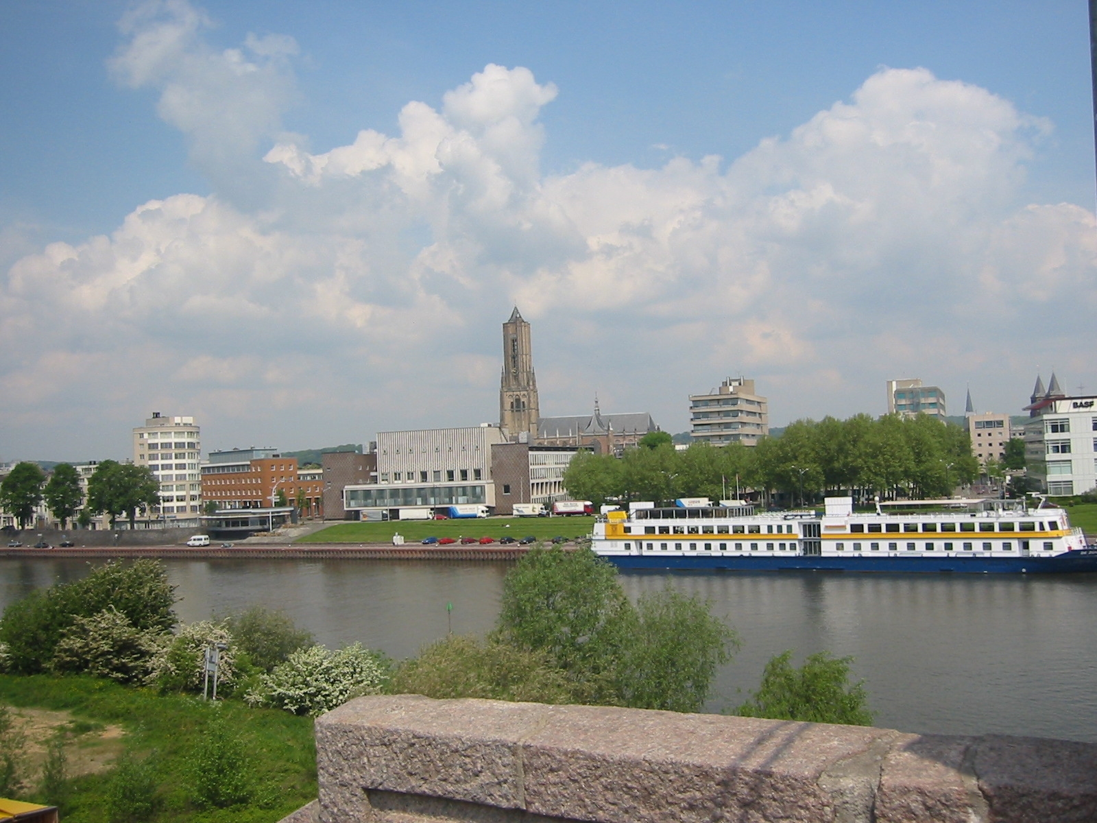
image_size = 280px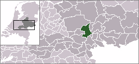
mapsize = 280px
subdivision_type = Country
subdivision_name =Netherlands
subdivision_type1 = Province
subdivision_name1 =Gelderland
leader_name =Pauline Krikke
leader_party = VVD
area_footnotes = (2006)
area_total_km2 = 101.53
area_land_km2 = 98.25
area_water_km2 = 3.28
population_as_of =1 January ,2007
population_note = Source: CBS, [http://statline.cbs.nl/ Statline] .
settlement_type = Municipality
population_total = 142636
population_density_km2 = 1452
population_metro = 773679
timezone = CET
utc_offset = +1
timezone_DST = CEST
utc_offset_DST = +2
latd = 51
latm = 59
latNS = N
longd = 5
longm = 55
longEW = E
website = [http://www.arnhem.nl www.arnhem.nl]Arnhem (Audio|068_Arnhem.ogg|pronunciation) (South Guelderish: "Èrnem") is a city and
municipality , situated in the eastern part of the Netherlands. It is the capital of the province ofGelderland and located near the river Lower Rhine as well as near theSt. Jansbeek , which was the source of the city's development. Arnhem has 142,634 residents (per January 1, 2007) and with that, it's the second largest city of the province Gelderland, afterNijmegen (160,681) as well as one of the 10 largest cities in the Netherlands. The municipality is part of thecity region Arnhem-Nijmegen, ametropolitan area with 722,181 inhabitants.History
The earliest history of Arnhem
Arnhem was first mentioned as such in 893 as "Arneym" or "Arentheym", referring to the many
eagle s that inhabited the hills and forests of Arnhem back then. Traces of human residence date back much further, however.The oldest archeological findings of human activity around Arnhem are two firestones of about 70.000 years ago. This comes from the
stone age , when theNeanderthal s lived in this part of Europe. In Schuytgraaf, tracks of a hunter's camp have been discovered from around 5000 BC. In Schaarsbergen, 12 grave hills were found from 2400 BC, which brought the so-called Neolithic revolution to the area of Arnhem, i.e. the rise of the farmers.The earliest settlement in Arnhem dates from 1500 BC, where traces have been found on the Hoogkamp, where the Van Goyenstraat is currently located. In the inner city, around the
St. Jansbeek , traces of settlement have been found from around 700 BC, while the first traces south to the Rhine have been found dating around 500 BC, in the "Schuytgraaf".Though the early tracks of settlements did show that the early residents of Arnhem descended from the forests on the hills, Arnhem was not built on the banks of the river Rhine, but a little higher along the
St. Jansbeek . Arnhem arose on the location where the road betweenNijmegen and Utrecht/Zutphen split. Seven streams provided the city with water, and only when the flow of the Rhine was changed in 1530, was the city located at the river.History of the city of Arnhem
The city of Arnhem had its real origins in 1233 when Otto II, count of Guelders from
Zutphen , conferred city rights on the town, which had belonged to the abbey of Prüm, settled in, and fortified it. Arnhem entered theHanseatic League in 1443. In 1473, it was captured byCharles the Bold of Burgundy. In 1514,Charles of Egmond ,duke ofGuelders , took it from the dukes of Burgundy; in 1543, it fell to theemperor Charles V. As capital of the so-called "Kwartier van Veluwe" it joined theUnion of Utrecht in 1579 and became part of the Republic of the Seven United Provinces of the Netherlands in 1585. The French occupied the town 1672–74; from 1795 to 1813, it was reoccupied by the French, by both revolutionary and imperial forces. In the early 19th century, the former fortifications were almost completely dismantled, to give space for town expansion. The "Sabelspoort" (Sabresgate) is the only remaining part of the medieval walls.In the 19th century, Arnhem was a genteel resort town famous for its picturesque beauty. It was known as "het Haagje van het oosten" (The Little Hague of the East), mainly because a number of rich former sugar barons or planters from the Indies settled there, as they did in
The Hague . Even now the city is famous for its parks and greenery. The urbanization in the north on hilly terrain is also quite unusual for the Netherlands.The Battle of Arnhem
In
World War II , duringOperation Market Garden (September 1944), theBritish 1st Airborne Division and thePolish 1st Independent Parachute Brigade were given the task of securing thebridge at Arnhem. The units wereparachute d and glider-landed into the area onSeptember 17 and later. The bulk of the force was dropped rather far from the bridge and never met their objective. A small force ofBritish 1st Airborne managed to make their way as far as the bridge but was unable to secure both sides. The Allied troops encountered stiff resistance from the German 9th and 10thSS Panzer divisions, which had been stationed in and around the city.The British force at the bridge eventually surrendered on
September 21 , and a full withdrawal of the remaining forces was made onSeptember 26 . These events were dramatized in the 1977 movie "A Bridge Too Far". (The bridge scenes in the movie were shot inDeventer , where a similar bridge over theIJssel was available, as the area around Arnhem bridge had changed too much to represent WWII era Arnhem). As a tribute, the rebuilt bridge was renamed 'John Frost-bridge' after the commander of the paratroopers. The official commemoration isSeptember 16 .The current bridge is the third almost-identical bridge built at the same spot. The Dutch Army destroyed the first bridge when the Germans invaded Holland in 1940. The second bridge was destroyed by the US Army Air Forces shortly after the 1944 battle.
A second battle of Arnhem took place in April 1945 when the city was liberated by
I Canadian Corps of theFirst Canadian Army .Although it is generally said, as above, that the British Force at the Northern end of the Arnhem bridge surrendered, General John Frost, who as a Lt Col commanded that force,fiercely denied that. He and his men were overwhelmed and were captured.
Names of Arnhem
Through the ages, the area of Arnhem has been known by various names, both official and unofficial.
Arnhem
The name "Arnhem" comes from "Arneym", which in turn comes from "Arentheem" or theLatin "Arenacum". This literally means "home of the eagle" (arend means eagle in Dutch) and stems from the manyeagle s that used to inhabit the hills and the woods of Arnhem. The name Arneym is first mentioned in 893 by the monastery Sint-Salvatorabdij. The naam Arenacum, the first mention of the area which became known as Arnhem, comes from the Roman era and means "with eagles".Èrnem
"Èrnem" is the name of the city in the local dialect, South Guelderish. In everyday life, the name is not often used by the inhabitants of Arnhem, who seldom speak with the Arnhemian accent/dialect any more. This accent is now mainly confined to the working class areas.Arnheim
"Arnheim" is the German name for Arnhem; it more clearly refers to the origin of the name (heim = home).Hague of the East ("Haagje van het Oosten" in Dutch)
In the second half of the 19th century, Arnhem was an elitist city and therefore was sometimes calledThe Hague of the east of the Netherlands.Green city on the Rhine or Park City
The image of Arnhem on the Rijn, with green forests in the background, has always been a much-loved theme of painters. Besides that, Arnhem has many parks. This has earned Arnhem the name "Green city on the Rhine" (from the 17th century) or "Park City" (from the 19th century).MeginhardeswichAround 814 there is a written reference to "Meginhardeswich", which is now, as the present-day "Meijnerswijk", part of Arnhem. In 847 it was plundered by the
Viking s.Oppidium Arnoldi Villa
When the Romans came to the Netherlands, around 50 BC, the area around was called "Oppidium Arnoldi Villa", or "higher situated living area". The settlement itself was called "Arenacum".Population centres
The municipality of Arnhem consists of the city of Arnhem and the following surrounding suburbs and former villages:
*Elden (Netherlands) (former village, now totally surrounded by other Arnhem neighbourhoods )
*Schaarsbergen Places of interest
The "Groote Kerk" (St. Eusebius), built 1452–1560, lost most of its tower during World War II, of which a part has been reconstructed to a modern design and opened in 1964. Officially the tower is not part of the church and is owned by the municipality.
The house of Maarten van Rossum, a general serving Duke Charles van Gelre, has been the town hall since 1830: The
satyr s in itsRenaissance ornamentation earned it the name "Duivelshuis" ("devil's house").The National Heritage Museum ("Nederlands Openluchtmuseum") is located outside the city. It is an
open air museum and park with antique houses, farms, and factories from different parts of the Netherlands.Burgers' Zoo is one of the biggest and most-visited zoo in the Netherlands, featuring an underwater walkthrough, desert, mangrove, rainforest, etc.The
Gelredome , the home field of Vitesse, the city'sEredivisie side in football, is a unique facility that features a retractable roof and a slide-out grass pitch. The concept has been fully duplicated since then byVeltins-Arena inGelsenkirchen ,Germany , andUniversity of Phoenix Stadium inGlendale, Arizona , USA, and partially by theSapporo Dome inJapan (which has a sliding pitch but a fixed roof).The
KEMA Toren (formerly known as "SEP Control Tower") is the highest structure of the town. It is a 140-m-high TV tower.Transport
Arnhem has a railway station, which is serviced by several intercity lines and the ICE to
Düsseldorf and further on toFrankfurt . Nowadays there are also trains departing all the way to Moscow, by NS HiSpeed. But only one train part makes it all the way to Moscow. The intercity lines provide direct connections to Utrecht,Nijmegen , andZutphen . It is also the terminus for several local railway services. Arnhem has three other stations, namely Arnhem Velperpoort, Arnhem Presikhaaf, and Arnhem Zuid.Arnhem is unique in the Netherlands with its trolleybus system.
Notable people
:"See also "
*Arnhem was the birthplace of physicist andNobel Prize laureateHendrik Lorentz in 1853.
*The English poet SirPhilip Sidney died in 1586 in Arnhem.
*The film comedienneTruus van Aalten was born in Arnhem in 1910.
*Dutch/British actressAudrey Hepburn attended Arnhem Conservatory during the war years 1939–45.
*Dutch water polo playerRik Toonen , winner of Olympic bronze in 1976, was born in Arnhem.
*Cirque du Soleil artist (Love (Cirque du Soleil) , 2006)Goos Meeuwsen was born in Arnhem.
*Graphic artistM. C. Escher moved to Arnhem when he was five and spent most of his youth there.Facts and Figures
* "Arnhem" is the name of a march composed by
A.E. Kelly .
*Arnhem Land inAustralia is named after the VOC-ship "Arnhem".
*Arnhem is twinned with theLondon Borough of Croydon .Climate
Infobox Weather
metric_first=Yes
single_line=Yes
location =Arnhem, Netherlands
Jan_Hi_°C =4.6
Feb_Hi_°C =5.6
Mar_Hi_°C =9.2
Apr_Hi_°C =12.8
May_Hi_°C =17.7
Jun_Hi_°C =19.9
Jul_Hi_°C =22.1
Aug_Hi_°C =22.3
Sep_Hi_°C =18.5
Oct_Hi_°C =13.8
Nov_Hi_°C =8.5
Dec_Hi_°C =5.7
Year_Hi_°C =13.4
Jan_Lo_°C =-0.5
Feb_Lo_°C =-0.6
Mar_Lo_°C =1.5
Apr_Lo_°C =3.0
May_Lo_°C =7.2
Jun_Lo_°C =9.8
Jul_Lo_°C =11.9
Aug_Lo_°C =11.7
Sep_Lo_°C =9.4
Oct_Lo_°C =6.1
Nov_Lo_°C =2.7
Dec_Lo_°C =0.8
Year_Lo_°C =5.3
Jan_REC_Hi_°C =14.5
Feb_REC_Hi_°C =16.8
Mar_REC_Hi_°C =22.5
Apr_REC_Hi_°C =27.3
May_REC_Hi_°C =31.6
Jun_REC_Hi_°C =33.9
Jul_REC_Hi_°C =35.6
Aug_REC_Hi_°C =34.9
Sep_REC_Hi_°C =30.7
Oct_REC_Hi_°C =26.4
Nov_REC_Hi_°C =17.3
Dec_REC_Hi_°C =15.1
Year_REC_Hi_°C =35.6
Jan_REC_Lo_°C =-24.2
Feb_REC_Lo_°C =-16.2
Mar_REC_Lo_°C =-17.0
Apr_REC_Lo_°C =-9.4
May_REC_Lo_°C =-2.4
Jun_REC_Lo_°C =-0.4
Jul_REC_Lo_°C =2.0
Aug_REC_Lo_°C =2.4
Sep_REC_Lo_°C =-0.9
Oct_REC_Lo_°C =-5.1
Nov_REC_Lo_°C =-9.1
Dec_REC_Lo_°C =-17.3
Year_REC_Lo_°C =-24.2
Jan_Precip_mm =83
Feb_Precip_mm =53
Mar_Precip_mm =77
Apr_Precip_mm =50
May_Precip_mm =63
Jun_Precip_mm =76
Jul_Precip_mm =72
Aug_Precip_mm =62
Sep_Precip_mm =76
Oct_Precip_mm =76
Nov_Precip_mm =85
Dec_Precip_mm =92
Year_Precip_mm =865
source = knmi.nl (Klimaatatlas van Nederland, normaalperiode 1971–2000, ISBN 90389 1191 2) (Temperature data 270 DEELEN, Precip data 541 ARNHEM)
accessdate = October 2008ee also
*
Arnhem Metal Meeting External links
* [http://www.arnhem.nl/english Municipality] Official website (English version)
* [http://www.vvvarnhemnijmegen.nl/1/1/uk/regio_s/arnhem VVV Arnhem] Tourist Office (English version)
* [http://www.coolregion.nl/arnhem-nijmegen-cool-region-1?set_language=en Arnhem Nijmegen Cool Region] City Region Arnhem Nijmegen (English version)
* [http://picture.bbnl.nl/pictures-of-arnhem.html Pictures of Arnhem]
* [http://arnhem.webcam.nl/ Webcam]
* [http://zien.info/arnhem.en Arnhem in Site] Virtual City Tour (English version).
Wikimedia Foundation. 2010.