- Mount Aniakchak
-
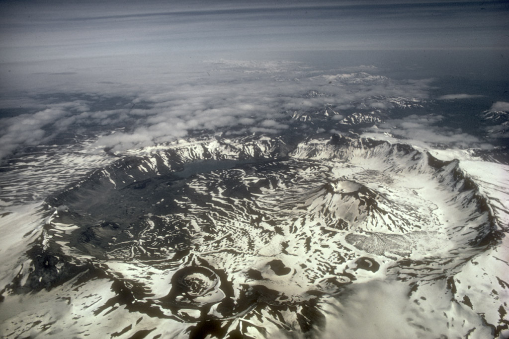
Mount Aniakchak 
Mount Aniakchak calderaElevation 4,400 ft (1,341 m) [1] Location Location Aniakchak National Monument and Preserve, Alaska, USA Range Aleutian Range[2] Coordinates 56°54′21″N 158°12′32″W / 56.90583°N 158.20889°WCoordinates: 56°54′21″N 158°12′32″W / 56.90583°N 158.20889°W[1] Topo map USGS Chignik D-1 Geology Type Caldera[2] Volcanic arc/belt Aleutian Arc Last eruption 1931[1]  Aniakchak 3D
Mount Aniakchak is a 3,700 year old volcanic[2] caldera (about 10 kilometers (6 mi) in diameter) located in the Aleutian Range of Alaska, United States. The area around the volcano is the Aniakchak National Monument and Preserve, maintained by the National Park Service. In November 1967, Aniakchak Caldera was designated as a National Natural Landmark by the National Park Service.[3]
Contents
Geological history
Aniakchak caldera formed during a major eruption of VEI=6, which left evidence in ice cores dated to 1645 BC.[4]
After the caldera forming events, from about 3500 years ago to the present, more than 20 eruptions occurred from vents on the caldera floor. Vent Mountain has been the source of numerous eruptions of ash, bombs, and lava flows since the formation of the caldera. From 1500 BCE to 1000 CE four lava domes were extruded on the caldera floor. Textural evidence indicates that these lava-dome eruptions occurred beneath Ancient Surprise Lake which was as deep as 100m. Ancient Surprise Lake drained catastrophically before about 1000 CE. (Surprise Lake is now about 2.75 km2 (680 acres) in area and up to 19.5 m (64.0 ft) deep.) Prior to or immediately after this draining, explosive eruptions of andesitic magma produced a cluster of three tuff cones in the southeastern part of the caldera.
Around 1500 CE, during one of the most violent events in recent history at Aniakchak, an estimated 0.75 to 1.0 km3 of material destroyed a preexisting edifice at Half Cone and inundated most of the caldera floor with pyroclastic flows, surges, and fallout many meters thick. During the final phase of this eruption, a lava flow filled the basin formed during the collapse of Half Cone.
Several more recent prehistoric eruptions occurred in the summit crater and along the south flank of Vent Mountain producing a field of blocky dacite lava flows against the south wall of the caldera. Minor eruptions immediately west and east of Vent Mountain produced a small scoria cone (Blocky Cone) and two maar craters (now water-filled) along the base of the southeast caldera wall.
European-descended geologists discovered the volcano in 1922.
The volcano's only eruption in historical time was that of 1931. The Jesuit priest Father Bernard Hubbard recorded it. "A small but impressive explosion pit was added to the pockmarked caldera floor that year. Many thousands of tons of ash lay strewn within the caldera and scattered up to 40 miles away over the small villages."[5]
Surprise Lake
Surprise Lake within the caldera is the source of the Aniakchak River, a National Wild River.
 Map showing volcanoes of Alaska Peninsula.
 Aniakchak Caldera
See also
References
- ^ a b c "Aniakchak Description and Statistics". Alaska Volcano Observatory. United States Geological Survey. http://www.avo.alaska.edu/volcanoes/volcinfo.php?volcname=Aniakchak. Retrieved 2009-01-19.
- ^ a b c "Aniakchak". Global Volcanism Program, Smithsonian Institution. http://www.volcano.si.edu/world/volcano.cfm?vnum=1102-09-. Retrieved 2009-01-19.
- ^ "Aniakchak Crater". National Park Service. 2004-02-05. http://www.nature.nps.gov/nnl/Registry/USA_Map/States/Alaska/nnl/ac/index.cfm. Retrieved 2009-01-19.
- ^ Pearce, N. J. G., J. A. Westgate, S. J. Preece, W. J. Eastwood, and W. T. Perkins (2004). "Identification of Aniakchak (Alaska) tephra in Greenland ice core challenges the 1645 BC date for Minoan eruption of Santorini". Geochem. Geophys. Geosyst. 5 (3): Q03005. Bibcode 2004GGG.....5.3005P. doi:10.1029/2003GC000672.
- ^ "Aniakchak National Monument & Preserve", pulled from chranger.com, 3 June 2011.
Sources
- Volcanoes of the Alaska Peninsula and Aleutian Islands-Selected Photographs
- Alaska Volcano Observatory
External links
Categories:- Active volcanoes
- Landforms of Lake and Peninsula Borough, Alaska
- Mountains of Alaska
- National Natural Landmarks in Alaska
- Subduction volcanoes
- Volcanic calderas of Alaska
- Volcanoes of Alaska
- VEI-6 volcanoes
- Crater lakes
- IUCN Category III
- Aleutian Range


Wikimedia Foundation. 2010.