- List of Colorado fourteeners
-
Main article: FourteenerSee also: 4000 meter peaks of Colorado
In mountaineering in the United States, a fourteener (or "14er") is a mountain peak that exceeds 14,000 feet (4267.2 meters) elevation. (This term is not usually significant outside the U.S.) This is a complete list of the 53 fourteeners in the U.S. State of Colorado with a minimum of 300 feet (91.44 meters) of topographic prominence. See the main fourteener article, which has a list of all of the fourteeners in the United States, for some information about how such lists are determined and caveats about elevation and ranking accuracy.
Topographic elevation is the vertical distance above the reference geoid, a precise mathematical model of the Earth's sea level as an equipotential gravitational surface. Topographic prominence is the elevation difference between the summit and the highest or key col to a higher summit. Topographic isolation is the minimum great circle distance to a point of higher elevation.
All elevations in the following table include an elevation adjustment from the National Geodetic Vertical Datum of 1929 (NGVD 29) to the North American Vertical Datum of 1988 (NAVD 88). For further information, please see this United States National Geodetic Survey note. If a summit elevation or prominence has a range of values, the arithmetic mean is cited.
Contents
Table
The following Colorado summits have at least 14,000 feet (4267.2 meters) of elevation, but less than 300 feet (91.44 meters) of prominence so they are unranked:
- Mount Cameron, elevation = 14,238 feet (4,340 m), prominence = 118 feet (36 m).
- El Diente Peak, elevation = 14,159 feet (4,316 m), prominence = 239 feet (73 m). On many fourteener lists.
- North Conundrum Peak, elevation > 14,040 feet (4,280 m), prominence = 200–280 feet.
- North Eolus, elevation = 14,039 feet (4,279 m), prominence = 159–199 feet.
- North Maroon Peak, elevation = 14,014 feet (4,271 m), prominence = 234 feet (71 m). On many fourteener lists.
Gallery
-

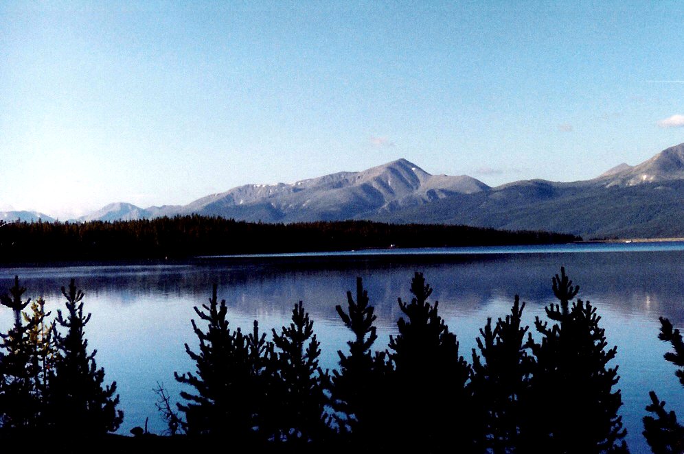
View of Mount Elbert with Turquoise Lake in the foreground.
-

View of Blanca Peak from Mount Lindsey.
-

The Crestones as seen from Mount Adams. From left to right: Crestone Needle, Crestone Peak, Columbia Point, Kit Carson Peak, Challenger Point.
-

View of Grays Peak on left and Torreys Peak on right.
-

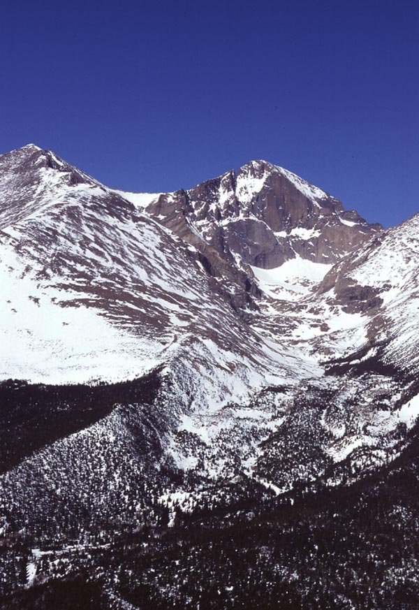
View of Longs Peak in Rocky Mountain National Park.
-

View of Mount Yale.
-

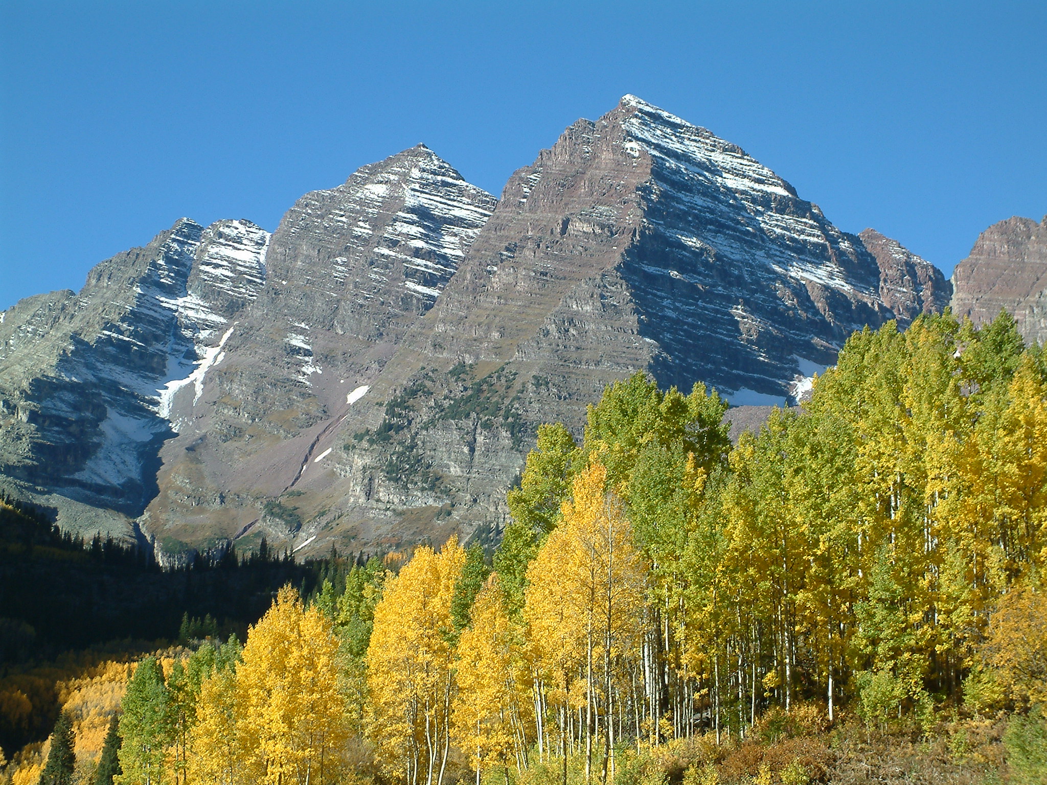
Autumn view of the Maroon Bells: Maroon Peak and North Maroon Peak.
-

View of Mount Sneffels.
-

View of Mount Democrat.
-

View of Mount Eolus.
-

Humboldt Peak as seen from Kit Carson Peak.
-
View of Mount Bierstadt with a marmot in the foreground.
-

View of Mount Lindsey.
-

View of Wilson Peak and the San Miguel Mountains.
-

Photograph of the Mount of the Holy Cross taken by William Henry Jackson in 1873.
See also
- Outline of Colorado
- Index of Colorado-related articles
- Lists of mountains
- List of mountains of the United States
- List of mountains of Colorado
- List of Colorado fourteeners
- List of mountains of Colorado
- List of mountains of the United States
- Mountain peaks of North America
- Mountain peaks of Greenland
- Mountain peaks of Canada
- Mountain peaks of the Rocky Mountains
- Mountain peaks of the United States
- Mountain peaks of Alaska
- Mountain peaks of California
- Mountain peaks of Colorado
- List of Colorado fourteeners
- Highest major peaks of Colorado
- 4000 meter peaks of Colorado
- Most prominent peaks of Colorado
- Ultra prominent peaks of Colorado
- Most isolated major peaks of Colorado
- 100 km isolated peaks of Colorado
- Mountain peaks of México
- Mountain peaks of Central America
- Mountain peaks of the Caribbean
- Physical geography
- Topography
- Topographic elevation
- Topographic isolation
- Topographic prominence
- Topographic summit
- Topography
- State of Colorado
- Geography of Colorado
- Category:Mountains of Colorado
- Geography of Colorado
References
- ^ The summit of Mount Elbert is the highest point of the Rocky Mountains and the State of Colorado.
- ^ "Mount Elbert". NGS Station Datasheet. United States National Geodetic Survey. http://www.ngs.noaa.gov/cgi-bin/ds_mark.prl?PidBox=KL0637. Retrieved February 17, 2010.
- ^ "Mount Elbert". Summits of the World. peakbagger.com. http://www.peakbagger.com/peak.aspx?pid=5736. Retrieved February 17, 2010.
- ^ The summit elevation of Mount Elbert includes a vertical adjustment of +1.995 m (+6.5 ft).
- ^ "Mount Massive". NGS Station Datasheet. United States National Geodetic Survey. http://www.ngs.noaa.gov/cgi-bin/ds_mark.prl?PidBox=KL0640. Retrieved February 17, 2010.
- ^ "Mount Massive". Summits of the World. peakbagger.com. http://www.peakbagger.com/peak.aspx?pid=5729. Retrieved February 17, 2010.
- ^ The summit elevation of Mount Massive includes a vertical adjustment of +2.087 m (+6.8 ft).
- ^ "Mount Harvard". NGS Station Datasheet. United States National Geodetic Survey. http://www.ngs.noaa.gov/cgi-bin/ds_mark.prl?PidBox=JL0879. Retrieved February 17, 2010.
- ^ "Mount Harvard". Summits of the World. peakbagger.com. http://www.peakbagger.com/peak.aspx?pid=5754. Retrieved February 17, 2010.
- ^ The summit elevation of Mount Harvard includes a vertical adjustment of +2.084 m (+6.8 ft).
- ^ The summit elevation of Mount Harvard includes a vertical offset of +1.8 m (+5.9 ft) from the benchmark.
- ^ "Blanca Peak". NGS Station Datasheet. United States National Geodetic Survey. http://www.ngs.noaa.gov/cgi-bin/ds_mark.prl?PidBox=HK0514. Retrieved March 2, 2010.
- ^ "Blanca Peak". Summits of the World. peakbagger.com. http://www.peakbagger.com/peak.aspx?pid=5921. Retrieved March 2, 2010.
- ^ The summit elevation of Blanca Peak includes a vertical adjustment of +1.755 m (+5.8 ft).
- ^ "La Plata Peak". Summits of the World. peakbagger.com. http://www.peakbagger.com/peak.aspx?pid=5744. Retrieved February 28, 2010.
- ^ The summit elevation of La Plata Peak includes a vertical adjustment of +1.983 m (+6.5 ft).
- ^ "Uncompahgre Peak". NGS Station Datasheet. United States National Geodetic Survey. http://www.ngs.noaa.gov/cgi-bin/ds_mark.prl?PidBox=JL0798. Retrieved February 17, 2010.
- ^ "Uncompahgre Peak". Summits of the World. peakbagger.com. http://www.peakbagger.com/peak.aspx?pid=5836. Retrieved February 17, 2010.
- ^ The summit elevation of Uncompahgre Peak includes a vertical adjustment of +1.967 m (+6.5 ft).
- ^ "Crestone Peak". Summits of the World. peakbagger.com. http://www.peakbagger.com/peak.aspx?pid=5908. Retrieved March 2, 2010.
- ^ The summit elevation of Crestone Peak includes a vertical adjustment of +1.76 m (+5.8 ft).
- ^ "Mount Lincoln". NGS Station Datasheet. United States National Geodetic Survey. http://www.ngs.noaa.gov/cgi-bin/ds_mark.prl?PidBox=KL0627. Retrieved February 17, 2010.
- ^ "Mount Lincoln". Summits of the World. peakbagger.com. http://www.peakbagger.com/peak.aspx?pid=5793. Retrieved February 17, 2010.
- ^ The summit elevation of Mount Lincoln includes a vertical adjustment of +2.098 m (+6.9 ft).
- ^ "Castle Peak". NGS Station Datasheet. United States National Geodetic Survey. http://www.ngs.noaa.gov/cgi-bin/ds_mark.prl?PidBox=KL0659. Retrieved February 17, 2010.
- ^ "Castle Peak". Summits of the World. peakbagger.com. http://www.peakbagger.com/peak.aspx?pid=5709. Retrieved February 17, 2010.
- ^ The summit elevation of Castle Peak includes a vertical adjustment of +2.165 m (+7.1 ft).
- ^ The summit of Grays Peak is the highest point on the Continental Divide of North America.
- ^ "Grays Peak". NGS Station Datasheet. United States National Geodetic Survey. http://www.ngs.noaa.gov/cgi-bin/ds_mark.prl?PidBox=KK2036. Retrieved February 17, 2010.
- ^ "Grays Peak". Summits of the World. peakbagger.com. http://www.peakbagger.com/peak.aspx?pid=5664. Retrieved February 17, 2010.
- ^ The summit elevation of Grays Peak includes a vertical adjustment of +1.881 m (+6.2 ft).
- ^ "Mount Antero". NGS Station Datasheet. United States National Geodetic Survey. http://www.ngs.noaa.gov/cgi-bin/ds_mark.prl?PidBox=JL0883. Retrieved February 17, 2010.
- ^ "Mount Antero". Summits of the World. peakbagger.com. http://www.peakbagger.com/peak.aspx?pid=5759. Retrieved February 17, 2010.
- ^ The summit elevation of Mount Antero includes a vertical adjustment of +2.071 m (+6.8 ft).
- ^ "Torreys Peak". NGS Station Datasheet. United States National Geodetic Survey. http://www.ngs.noaa.gov/cgi-bin/ds_mark.prl?PidBox=KK2037. Retrieved March 13, 2010.
- ^ "Torreys Peak". Summits of the World. peakbagger.com. http://www.peakbagger.com/peak.aspx?pid=5662. Retrieved March 13, 2010.
- ^ The summit elevation of Torreys Peak includes a vertical adjustment of +1.897 m (+6.2 ft).
- ^ "Quandary Peak". NGS Station Datasheet. United States National Geodetic Survey. http://www.ngs.noaa.gov/cgi-bin/ds_mark.prl?PidBox=KL0622. Retrieved March 15, 2010.
- ^ "Quandary Peak". Summits of the World. peakbagger.com. http://www.peakbagger.com/peak.aspx?pid=5788. Retrieved March 15, 2010.
- ^ The summit elevation of Quandary Peak includes a vertical adjustment of +2.071 m (+6.8 ft).
- ^ "Mount Evans". NGS Station Datasheet. United States National Geodetic Survey. http://www.ngs.noaa.gov/cgi-bin/ds_mark.prl?PidBox=KK2030. Retrieved February 17, 2010.
- ^ "Mount Evans". Summits of the World. peakbagger.com. http://www.peakbagger.com/peak.aspx?pid=5676. Retrieved February 17, 2010.
- ^ The summit elevation of Mount Evans includes a vertical adjustment of +1.827 m (+6.0 ft).
- ^ "Longs Peak". NGS Station Datasheet. United States National Geodetic Survey. http://www.ngs.noaa.gov/cgi-bin/ds_mark.prl?PidBox=LL1346. Retrieved February 17, 2010.
- ^ "Longs Peak". Summits of the World. peakbagger.com. http://www.peakbagger.com/peak.aspx?pid=5642. Retrieved February 17, 2010.
- ^ The summit elevation of Longs Peak includes a vertical adjustment of +1.652 m (+5.4 ft).
- ^ "Mount Wilson". Summits of the World. peakbagger.com. http://www.peakbagger.com/peak.aspx?pid=5820. Retrieved March 2, 2010.
- ^ The summit elevation of Mount Wilson includes a vertical adjustment of +1.899 m (+6.2 ft).
- ^ "Mount Shavano". NGS Station Datasheet. United States National Geodetic Survey. http://www.ngs.noaa.gov/cgi-bin/ds_mark.prl?PidBox=JL0887. Retrieved March 13, 2010.
- ^ "Mount Shavano". Summits of the World. peakbagger.com. http://www.peakbagger.com/peak.aspx?pid=5762. Retrieved March 13, 2010.
- ^ The summit elevation of Mount Shavano includes a vertical adjustment of +2.031 m (+6.7 ft).
- ^ "Mount Princeton". NGS Station Datasheet. United States National Geodetic Survey. http://www.ngs.noaa.gov/cgi-bin/ds_mark.prl?PidBox=JL0886. Retrieved February 17, 2010.
- ^ "Mount Princeton". Summits of the World. peakbagger.com. http://www.peakbagger.com/peak.aspx?pid=5757. Retrieved February 17, 2010.
- ^ The summit elevation of Mount Princeton includes a vertical adjustment of +2.075 m (+6.8 ft).
- ^ "Mount Belford". NGS Station Datasheet. United States National Geodetic Survey. http://www.ngs.noaa.gov/cgi-bin/ds_mark.prl?PidBox=JL0884. Retrieved March 13, 2010.
- ^ "Mount Belford". Summits of the World. peakbagger.com. http://www.peakbagger.com/peak.aspx?pid=5747. Retrieved March 13, 2010.
- ^ The summit elevation of Mount Belford includes a vertical adjustment of +2.081 m (+6.8 ft).
- ^ "Crestone Needle". Summits of the World. peakbagger.com. http://www.peakbagger.com/peak.aspx?pid=5909. Retrieved March 13, 2010.
- ^ The summit elevation of Crestone Needle includes a vertical adjustment of +1.763 m (+5.8 ft).
- ^ "Mount Yale". NGS Station Datasheet. United States National Geodetic Survey. http://www.ngs.noaa.gov/cgi-bin/ds_mark.prl?PidBox=JL0889. Retrieved February 17, 2010.
- ^ "Mount Yale". Summits of the World. peakbagger.com. http://www.peakbagger.com/peak.aspx?pid=5756. Retrieved February 17, 2010.
- ^ The summit elevation of Mount Yale includes a vertical adjustment of +2.036 m (+6.7 ft).
- ^ The summit elevation of Mount Yale includes a vertical offset of +0.6 m (+2.0 ft) from the benchmark.
- ^ "Mount Bross". NGS Station Datasheet. United States National Geodetic Survey. http://www.ngs.noaa.gov/cgi-bin/ds_mark.prl?PidBox=KL0628. Retrieved March 13, 2010.
- ^ "Mount Bross". Summits of the World. peakbagger.com. http://www.peakbagger.com/peak.aspx?pid=5796. Retrieved March 13, 2010.
- ^ The summit elevation of Mount Bross includes a vertical adjustment of +2.044 m (+6.7 ft).
- ^ "Kit Carson Mountain". Summits of the World. peakbagger.com. http://www.peakbagger.com/peak.aspx?pid=5903. Retrieved March 13, 2010.
- ^ The summit elevation of Kit Carson Mountain includes a vertical adjustment of +1.773 m (+5.8 ft).
- ^ "Maroon Peak". NGS Station Datasheet. United States National Geodetic Survey. http://www.ngs.noaa.gov/cgi-bin/ds_mark.prl?PidBox=KL0805. Retrieved February 17, 2010.
- ^ "Maroon Peak". Summits of the World. peakbagger.com. http://www.peakbagger.com/peak.aspx?pid=5701. Retrieved February 17, 2010.
- ^ The summit elevation of Maroon Peak includes a vertical adjustment of +2.048 m (+6.7 ft).
- ^ "Tabeguache Peak". NGS Station Datasheet. United States National Geodetic Survey. http://www.ngs.noaa.gov/cgi-bin/ds_mark.prl?PidBox=JL0888. Retrieved March 13, 2010.
- ^ "Tabeguache Peak". Summits of the World. peakbagger.com. http://www.peakbagger.com/peak.aspx?pid=5761. Retrieved March 13, 2010.
- ^ The summit elevation of Tabeguache Peak includes a vertical adjustment of +2.107 m (+6.9 ft).
- ^ "Mount Oxford (Colorado)". NGS Station Datasheet. United States National Geodetic Survey. http://www.ngs.noaa.gov/cgi-bin/ds_mark.prl?PidBox=JL0885. Retrieved March 13, 2010.
- ^ "Mount Oxford (Colorado)". Summits of the World. peakbagger.com. http://www.peakbagger.com/peak.aspx?pid=5746. Retrieved March 13, 2010.
- ^ The summit elevation of Mount Oxford (Colorado) includes a vertical adjustment of +2.042 m (+6.7 ft).
- ^ "Mount Sneffels". NGS Station Datasheet. United States National Geodetic Survey. http://www.ngs.noaa.gov/cgi-bin/ds_mark.prl?PidBox=JL0826. Retrieved February 17, 2010.
- ^ "Mount Sneffels". Summits of the World. peakbagger.com. http://www.peakbagger.com/peak.aspx?pid=5830. Retrieved February 17, 2010.
- ^ The summit elevation of Mount Sneffels includes a vertical adjustment of +1.879 m (+6.2 ft).
- ^ "Mount Democrat". NGS Station Datasheet. United States National Geodetic Survey. http://www.ngs.noaa.gov/cgi-bin/ds_mark.prl?PidBox=KL0630. Retrieved March 13, 2010.
- ^ "Mount Democrat". Summits of the World. peakbagger.com. http://www.peakbagger.com/peak.aspx?pid=5795. Retrieved March 13, 2010.
- ^ The summit elevation of Mount Democrat includes a vertical adjustment of +2.086 m (+6.8 ft).
- ^ "Capitol Peak". NGS Station Datasheet. United States National Geodetic Survey. http://www.ngs.noaa.gov/cgi-bin/ds_mark.prl?PidBox=KL0688. Retrieved February 17, 2010.
- ^ "Capitol Peak". Summits of the World. peakbagger.com. http://www.peakbagger.com/peak.aspx?pid=5695. Retrieved February 17, 2010.
- ^ The summit elevation of Capitol Peak includes a vertical adjustment of +1.991 m (+6.5 ft).
- ^ "Pikes Peak". NGS Station Datasheet. United States National Geodetic Survey. http://www.ngs.noaa.gov/cgi-bin/ds_mark.prl?PidBox=JK1242. Retrieved February 17, 2010.
- ^ "Pikes Peak". Summits of the World. peakbagger.com. http://www.peakbagger.com/peak.aspx?pid=5689. Retrieved February 17, 2010.
- ^ The summit elevation of Pikes Peak includes a vertical adjustment of +1.678 m (+5.5 ft).
- ^ "Snowmass Mountain". NGS Station Datasheet. United States National Geodetic Survey. http://www.ngs.noaa.gov/cgi-bin/ds_mark.prl?PidBox=KL0813. Retrieved March 13, 2010.
- ^ "Snowmass Mountain". Summits of the World. peakbagger.com. http://www.peakbagger.com/peak.aspx?pid=5697. Retrieved March 13, 2010.
- ^ The summit elevation of Snowmass Mountain includes a vertical adjustment of +1.98 m (+6.5 ft).
- ^ "Windom Peak". Summits of the World. peakbagger.com. http://www.peakbagger.com/peak.aspx?pid=5861. Retrieved March 13, 2010.
- ^ The summit elevation of Windom Peak includes a vertical adjustment of +1.785 m (+5.9 ft).
- ^ "Mount Eolus". Summits of the World. peakbagger.com. http://www.peakbagger.com/peak.aspx?pid=5860. Retrieved February 28, 2010.
- ^ The summit elevation of Mount Eolus includes a vertical adjustment of +1.756 m (+5.8 ft).
- ^ "Challenger Point". Summits of the World. peakbagger.com. http://www.peakbagger.com/peak.aspx?pid=5902. Retrieved March 13, 2010.
- ^ The summit elevation of Challenger Point includes a vertical adjustment of +1.752 m (+5.7 ft).
- ^ "Mount Columbia". NGS Station Datasheet. United States National Geodetic Survey. http://www.ngs.noaa.gov/cgi-bin/ds_mark.prl?PidBox=JL0878. Retrieved March 13, 2010.
- ^ "Mount Columbia". Summits of the World. peakbagger.com. http://www.peakbagger.com/peak.aspx?pid=5755. Retrieved March 13, 2010.
- ^ The summit elevation of Mount Columbia includes a vertical adjustment of +2.081 m (+6.8 ft).
- ^ "Missouri Mountain". NGS Station Datasheet. United States National Geodetic Survey. http://www.ngs.noaa.gov/cgi-bin/ds_mark.prl?PidBox=JL0882. Retrieved March 13, 2010.
- ^ "Missouri Mountain". Summits of the World. peakbagger.com. http://www.peakbagger.com/peak.aspx?pid=5748. Retrieved March 13, 2010.
- ^ The summit elevation of Missouri Mountain includes a vertical adjustment of +2.113 m (+6.9 ft).
- ^ "Humboldt Peak". Summits of the World. peakbagger.com. http://www.peakbagger.com/peak.aspx?pid=5906. Retrieved March 13, 2010.
- ^ The summit elevation of Humboldt Peak includes a vertical adjustment of +1.79 m (+5.9 ft).
- ^ "Mount Bierstadt". NGS Station Datasheet. United States National Geodetic Survey. http://www.ngs.noaa.gov/cgi-bin/ds_mark.prl?PidBox=KK2029. Retrieved March 13, 2010.
- ^ "Mount Bierstadt". Summits of the World. peakbagger.com. http://www.peakbagger.com/peak.aspx?pid=5678. Retrieved March 13, 2010.
- ^ The summit elevation of Mount Bierstadt includes a vertical adjustment of +1.797 m (+5.9 ft).
- ^ "Sunlight Peak". Summits of the World. peakbagger.com. http://www.peakbagger.com/peak.aspx?pid=5858. Retrieved March 13, 2010.
- ^ The summit elevation of Sunlight Peak includes a vertical adjustment of +1.804 m (+5.9 ft).
- ^ "Handies Peak". NGS Station Datasheet. United States National Geodetic Survey. http://www.ngs.noaa.gov/cgi-bin/ds_mark.prl?PidBox=HL0635. Retrieved February 17, 2010.
- ^ "Handies Peak". Summits of the World. peakbagger.com. http://www.peakbagger.com/peak.aspx?pid=5840. Retrieved February 17, 2010.
- ^ The summit elevation of Handies Peak includes a vertical adjustment of +1.994 m (+6.5 ft).
- ^ "Culebra Peak". Summits of the World. peakbagger.com. http://www.peakbagger.com/peak.aspx?pid=5924. Retrieved March 2, 2010.
- ^ The summit elevation of Culebra Peak includes a vertical adjustment of +1.74 m (+5.7 ft).
- ^ "Ellingwood Point". Summits of the World. peakbagger.com. http://www.peakbagger.com/peak.aspx?pid=5919. Retrieved March 13, 2010.
- ^ The summit elevation of Ellingwood Point includes a vertical adjustment of +1.789 m (+5.9 ft).
- ^ "Mount Lindsey". Summits of the World. peakbagger.com. http://www.peakbagger.com/peak.aspx?pid=5918. Retrieved March 13, 2010.
- ^ The summit elevation of Mount Lindsey includes a vertical adjustment of +1.691 m (+5.5 ft).
- ^ "Little Bear Peak". Summits of the World. peakbagger.com. http://www.peakbagger.com/peak.aspx?pid=5922. Retrieved March 13, 2010.
- ^ The summit elevation of Little Bear Peak includes a vertical adjustment of +1.733 m (+5.7 ft).
- ^ "Mount Sherman". Summits of the World. peakbagger.com. http://www.peakbagger.com/peak.aspx?pid=5803. Retrieved March 13, 2010.
- ^ The summit elevation of Mount Sherman includes a vertical adjustment of +2.029 m (+6.7 ft).
- ^ "Redcloud Peak". Summits of the World. peakbagger.com. http://www.peakbagger.com/peak.aspx?pid=5847. Retrieved March 13, 2010.
- ^ The summit elevation of Redcloud Peak includes a vertical adjustment of +2.015 m (+6.6 ft).
- ^ "Pyramid Peak". NGS Station Datasheet. United States National Geodetic Survey. http://www.ngs.noaa.gov/cgi-bin/ds_mark.prl?PidBox=KL0810. Retrieved March 13, 2010.
- ^ "Pyramid Peak". Summits of the World. peakbagger.com. http://www.peakbagger.com/peak.aspx?pid=5700. Retrieved March 13, 2010.
- ^ The summit elevation of Pyramid Peak includes a vertical adjustment of +2.009 m (+6.6 ft).
- ^ "Wilson Peak". Summits of the World. peakbagger.com. http://www.peakbagger.com/peak.aspx?pid=5816. Retrieved March 13, 2010.
- ^ The summit elevation of Wilson Peak includes a vertical adjustment of +1.877 m (+6.2 ft).
- ^ "San Luis Peak". NGS Station Datasheet. United States National Geodetic Survey. http://www.ngs.noaa.gov/cgi-bin/ds_mark.prl?PidBox=HL0570. Retrieved February 17, 2010.
- ^ "San Luis Peak". Summits of the World. peakbagger.com. http://www.peakbagger.com/peak.aspx?pid=5874. Retrieved February 17, 2010.
- ^ The summit elevation of San Luis Peak includes a vertical adjustment of +2.098 m (+6.9 ft).
- ^ "Wetterhorn Peak". Summits of the World. peakbagger.com. http://www.peakbagger.com/peak.aspx?pid=5838. Retrieved March 13, 2010.
- ^ The summit elevation of Wetterhorn Peak includes a vertical adjustment of +1.903 m (+6.2 ft).
- ^ "Huron Peak". NGS Station Datasheet. United States National Geodetic Survey. http://www.ngs.noaa.gov/cgi-bin/ds_mark.prl?PidBox=JL0880. Retrieved March 13, 2010.
- ^ "Huron Peak". Summits of the World. peakbagger.com. http://www.peakbagger.com/peak.aspx?pid=5749. Retrieved March 13, 2010.
- ^ The summit elevation of Huron Peak includes a vertical adjustment of +2.08 m (+6.8 ft).
- ^ The summit elevation of Huron Peak includes a vertical offset of +0.6 m (+2.0 ft) from the benchmark.
- ^ "Mount of the Holy Cross". NGS Station Datasheet. United States National Geodetic Survey. http://www.ngs.noaa.gov/cgi-bin/ds_mark.prl?PidBox=KL0649. Retrieved February 17, 2010.
- ^ "Mount of the Holy Cross". Summits of the World. peakbagger.com. http://www.peakbagger.com/peak.aspx?pid=5725. Retrieved February 17, 2010.
- ^ The summit elevation of Mount of the Holy Cross includes a vertical adjustment of +1.926 m (+6.3 ft).
- ^ "Sunshine Peak". Summits of the World. peakbagger.com. http://www.peakbagger.com/peak.aspx?pid=5848. Retrieved March 13, 2010.
- ^ The summit elevation of Sunshine Peak includes a vertical adjustment of +1.969 m (+6.5 ft).
External links
- National Geodetic Survey website
- United States Geological Survey website
- Colorado Geological Survey website
- "Rocky Mountains @ Peakbagger". Peakbagger.com. http://www.peakbagger.com/range.aspx?rid=14.
- Peakmind: List of 14er Trip Reports
Categories:- Fourteeners of Colorado
- Lists of mountains of the United States
- Colorado-related lists
- Rocky Mountains
- Lists of mountains by elevation


Wikimedia Foundation. 2010.