- Mispillion River
-
Mispillion River River 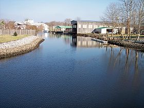 The Mispillion River in Milford in 2006
Country United States State Delaware Source - location near Milford - coordinates 38°52′53″N 75°30′00″W / 38.88139°N 75.5°W [1] Mouth Delaware Bay - elevation 3 ft (1 m) [1] - coordinates 38°57′05″N 75°18′48″W / 38.95139°N 75.31333°W [1] Length 15 mi (24 km) approximately[2] Basin 76 sq mi (197 km2) [3] 
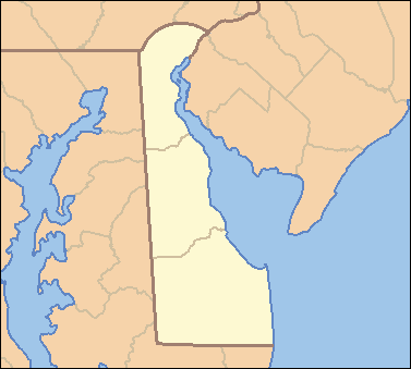
 Location of the mouth of the Mispillion River
The Mispillion River is a river flowing to Delaware Bay in southern Delaware in the United States. It is approximately 15 miles (24 km) long and drains an area of 76 square miles (197 km²) on the Atlantic Coastal Plain.
It rises in northern Sussex County, approximately 3 miles (5 km) southwest of Milford, and flows generally east-northeastwardly, defining the boundary between Sussex and Kent counties; it passes through the center of Milford on its course to its mouth at Delaware Bay, 16 miles (26 km) northwest of Cape Henlopen.[2][4] The lower 12 miles (19 km) of the river are considered by the U.S. Army Corps of Engineers to be navigable.[5]
A boardwalk known as the Mispillion Riverwalk follows the river in Milford. As of 2003[update], an effort was underway to preserve a greenway along the river upstream and downstream of Milford.[6]
Variant names and spellings
According to the Geographic Names Information System, the Mispillion River has also been known historically as:[1]
- Masphilion Creek
- Maspillon Creek
- Mispalling Creek
- Mispelion Creek
- Mispelon Creek
- Mispening Creek
- Mispeninge Creek
- Misperange River
- Mispilian Creek
- Mispliant Creek
- Misspann Creek
- Muskmellon Creek
- Musmillion River
- Musphilion Creek
- Muspilion Creek
See also
- List of Delaware rivers
- Mispillion Light
- USS Mispillion (AO-105)
- USNS Mispillion (T-AO-105)
References
- ^ a b c d Geographic Names Information System. "GNIS entry for Mispillion River (Feature ID #214330)". http://geonames.usgs.gov/pls/gnispublic/f?p=gnispq:3:::NO::P3_FID:214330. Retrieved 2007-02-05.
- ^ a b "Columbia Gazetteer of North America entry for Mispillion River". 2000. http://www.bartelby.com/69/23/M08223.html. Retrieved 2007-02-05.
- ^ United States Environmental Protection Agency (2005). "Decision Rationale: Total Maximum Daily Load (TMDLs) for Bacteria and Nutrient Impairments on the Mispillion River and Cedar Creek Watershed, Kent and Sussex Counties, Delaware". pp. pp.1–2.. http://www.epa.gov/reg3wapd/tmdl/de_tmdl/MispillionRiver/index.html. Retrieved 2007-02-05.
- ^ DeLorme (2004). Maryland Delaware Atlas & Gazetteer. pp.52-53. Yarmouth, Maine: DeLorme. ISBN 0-89933-279-X.
- ^ U.S. Army Corps of Engineers, Philadelphia District. "Navigable waterways of the Philadelphia District.". http://www.nap.usace.army.mil/channel/nww.htm. Retrieved 2007-02-05.
- ^ Delaware Division of Parks and Recreation. "Greenways & Trails". Archived from the original on 2007-03-11. http://web.archive.org/web/20070311024101/http://www.destateparks.com/greenway/Traillistmurderkill.htm. Retrieved 2007-02-05.
 State of Delaware
Topics - Index
- Architecture
- Communications
- Culture
- Delegations
- Demographics
- Economy
- Education
- Geography
- Government
- History
- Images
- Landmarks
- Law
- Military
- Music
- Nature
- Organizations
- Parks
- Sports
- Symbols
- Transportation
- Visitor Attractions
Cities Towns - Arden
- Ardencroft
- Ardentown
- Bellefonte
- Bethany Beach
- Bethel
- Blades
- Bowers
- Bridgeville
- Camden
- Cheswold
- Clayton
- Dagsboro
- Delmar
- Dewey Beach
- Ellendale
- Elsmere
- Farmington
- Felton
- Fenwick Island
- Frankford
- Frederica
- Georgetown
- Greenwood
- Hartly
- Henlopen Acres
- Houston
- Kenton
- Laurel
- Leipsic
- Little Creek
- Magnolia
- Middletown
- Millsboro
- Millville
- Milton
- Newport
- Ocean
- Odessa
- Selbyville
- Slaughter Beach
- South Bethany
- Townsend
- Viola
- Woodside
- Wyoming
Counties Categories:- Rivers of Delaware
- Landforms of Sussex County, Delaware
- Landforms of Kent County, Delaware

Wikimedia Foundation. 2010.