- Geography of the Maldives
-

- See also Atolls of the Maldives for an in-depth description of the atolls.
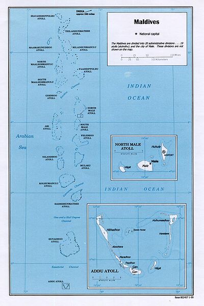
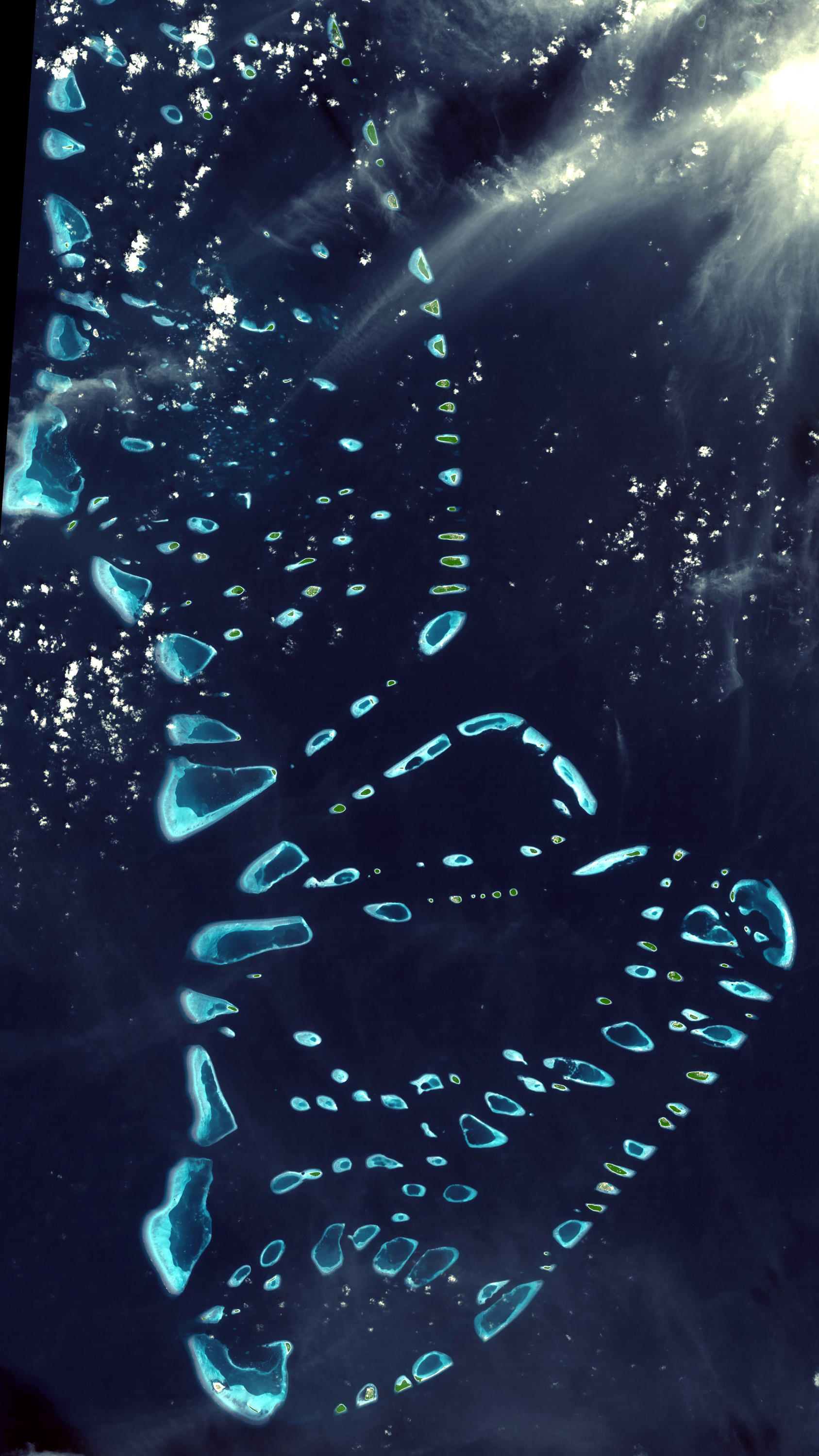
Maldives is a country of South Asia, situated in the Indian Ocean, south-southwest of India. It consists of approximately 1,190 coral islands grouped in a double chain of 26 atolls, spread over roughly 90,000 square kilometers, making this one of the most disparate countries in the world. Composed of live coral reefs and sand bars, the atolls are situated atop a submarine ridge 960 kilometers long that rises abruptly from the depths of the Indian Ocean and runs from north to south. Only near the southern end of this natural coral barricade do two open passages permit safe ship navigation from one side of the Indian Ocean to the other through the territorial waters of Maldives. For administrative purposes the Maldives government organized these atolls into nineteen administrative divisions.
The largest island of Maldives is Gan, which belongs to Laamu Atoll or Hahdhummathi Maldives. In Addu Atoll the westernmost islands are connected by roads over the reef and the total length of the road is 14 km.
Geographic coordinates: 3°15′N 73°00′E / 3.25°N 73°E
Contents
Physical Geography
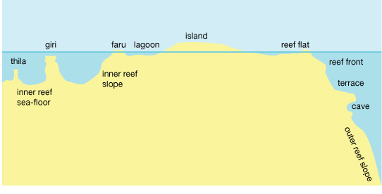
See also: List of islands of the Maldives Cross section of a coral reef in the Maldives.
Most Atolls of the Maldives consist of a large, ring-shaped coral reef supporting numerous small islands. Islands average only one to two square kilometers in area, and lie between one and 1.5 meters above mean sea level. Although some of the larger atolls are approximately 50 kilometers long from north to south, and 30 kilometers wide from east to west, no individual island is longer than eight kilometers. Maldives has no hills, but some islands have dunes which can reach 2.4 meters / 8 feet above sea level, like the NW coast of Hithadhoo (Seenu Atoll) in Addu Atoll. Islands are too small to have rivers, but small lakes and marshes can be found in some islands.
On average, each atoll has approximately 5 to 10 inhabited islands; the uninhabited islands of each atoll number approximately 20 to 60. Some atolls, however, consist of one large, isolated island surrounded by a steep coral beach. The most notable example of this type of atoll is the large island of Fuvahmulah situated in the Equatorial Channel.
The tropical vegetation of Maldives differs in the inhabited and in the uninhabited islands. Inhabited islands have small groves of banana, papaya, drumstick and citrus trees by the homesteads, while breadfruit trees and coconut palms are grown in available patches of land. On the other hand uninhabited islands have mostly different kinds of bushes (magū, kuredi, kandū, boshi) along the waterline as well as some coconut trees.
Some islands are marshy, while others are higher owing to sand and gravel having been piled up by wave action. Often the soil is highly alkaline, and a deficiency in nitrogen, potash, and iron severely limits agricultural potential. Ten percent of the land, or about 26 km², is cultivated with taro, bananas, coconuts, and other fruit. Only the lush island of Fuvammulah produces fruits such as oranges and pineapples partly because the terrain of Fuvammulah is higher than most other islands, leaving the groundwater less subject to seawater penetration. However, as population grows, even in this island the cultivated areas are shrinking rapidly.
Freshwater floats in a layer known as "Ghyben/Herzberg lens" above the seawater that permeates the limestone and coral sands of the islands. These lenses are shrinking rapidly on Male and on many islands where there are resorts catering to foreign tourists. Mango trees already have been reported dying on Male because of salt penetration. Most residents of the atolls depend on groundwater or rainwater for drinking purposes.
Climate
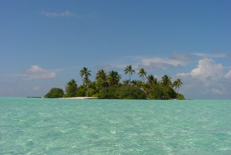
See also: Climate One of the many uninhabited islands of the Maldives.
The temperature of Maldives ranges between 24 and 33 °C (75.2 and 91.4 °F) throughout the year. Although the humidity is relatively high, the constant sea breezes help to keep the air moving. Two seasons dominate Maldives' weather: the dry season associated with the winter northeast monsoon and the rainy season brought by the summer southwest monsoon. The annual rainfall averages 2,540 millimeters (100 in) in the north and 3,810 millimeters (150 in) in the south.
The weather in Maldives is affected by the large landmass of the South Asia to the north. The presence of this landmass causes differential heating of land and water. Scientists also cite other factors in the formation of monsoons, including the barrier of the Himalayas on the northern fringe of the South Asia and the sun's northward tilt, which shifts the jet stream north. These factors set off a rush of moisture-rich air from the Indian Ocean over the South Asia, resulting in the southwest monsoon. The hot air that rises over the South Asia during April and May creates low-pressure areas into which the cooler, moisture-bearing winds from the Indian Ocean flow. In Maldives, the wet southwest monsoon lasts from the end of April to the end of October and brings the worst weather with strong winds and storms. In May 1991 violent monsoon winds created tidal waves that damaged thousands of houses and piers, flooded arable land with seawater, and uprooted thousands of fruit trees. The damage caused was estimated at US$30 million.
The shift from the moist southwest monsoon to the dry northeast monsoon over the South Asia occurs during October and November. During this period, the northeast winds contribute to the formation of the northeast monsoon, which reaches Maldives in the beginning of December and lasts until the end of March. However, the weather patterns of Maldives do not always conform to the monsoon patterns of the South Asia. Rain showers over the whole country have been known to persist for up to one week during the midst of the dry season.
Area and boundaries
 North Miladhun madulu atoll, Maldives
Area:
total: 300 km²
land: 300 km²
water: 0 km²Coastline: 644 km
Maritime claims: measured from claimed archipelagic baselines
contiguous zone: 24 nmi (44.4 km; 27.6 mi)
exclusive economic zone: 200 nmi (370.4 km; 230.2 mi)
territorial sea: 12 nmi (22.2 km; 13.8 mi)Elevation extremes:
lowest point: Indian Ocean 0 m
highest point: unnamed location on Vilingili Island in the Addu Atoll 2.4 m (Maldives is the flattest country in the world, i.e. they have the lowest high-point of any country in the world).Resources and land use
Natural resources:[1] fish
Land use:
arable land: 13.33%
permanent crops: 30%
permanent pastures: 3%
forests and woodland: 3%
other: 51% (1993 est.)Irrigated land: NA
Environmental concerns
Natural hazards: low level of islands makes them very sensitive to sea level rise.
Some scientists fear it could be underwater by 2050 or 2100. The UN's environmental panel has warned that, at current rates, sea level would be high enough to make the country uninhabitable by 2100.[2][3] President Mohamed Nasheed aims to turn the Maldives into an entirely carbon neutral nation by 2020.[4]Environment - current issues: depletion of freshwater aquifers threatens water supplies, global warming and sea level rise, coral reef bleaching, overpopulation, deforestation, and air pollution[5]
Environment - international agreements: Biodiversity, Climate Change, Climate Change-Kyoto Protocol, Desertification, Hazardous Wastes, Ozone Layer Protection, Law of the Sea [6]
Statistics
- Position: degree of latitude: 07° 06'30" N to 00° 41'48" S and degree of longitude: 72° 32'30" E to 73° 45'54" E westside of India and Sri Lanka.
- Range: in length approx. 750 km (from north to south) / in width approx. 120 km (from west to east)
- Land territory: 1,196 mostly deserted islands with a total area of approx. 298 km².
- The islands are in average 1.8 m above sea level.
- Distances: shortest distance to India: approx. 340 km and to Sri Lanka approx. 700 km.
Nearest nation
India (Laccadives)
References
- ^ [https://www.cia.gov/library/publications/the-world-factbook/geos/mv.html CIA World Factbook accessed 01 May 2009
- ^ Megan Angelo (1 May 2009). "Honey, I Sunk the Maldives: Environmental changes could wipe out some of the world's most well-known travel destinations". http://travel.yahoo.com/p-interests-27384279;_ylc=X3oDMTFxcWIyczFpBF9TAzI3MTYxNDkEX3MDMjcxOTQ4MQRzZWMDZnAtdG9kYXltb2QEc2xrA21hbGRpdmVzLTQtMjgtMDk-.
- ^ Kristina Stefanova (19 April 2009). "Climate refugees in Pacific flee rising sea". http://www.washingtontimes.com/news/2009/apr/19/rising-sea-levels-in-pacific-create-wave-of-migran/.
- ^ "Maldives aims for action behind words on climate change". http://green.yahoo.com/news/afp/20090918/lf_afp/maldivesclimatewarmingenvironmenttravel.html. Retrieved 18 Sept. 2009.
- ^ [https://www.cia.gov/library/publications/the-world-factbook/geos/mv.html CIA World Factbook accessed 01 May 2009
- ^ [https://www.cia.gov/library/publications/the-world-factbook/geos/mv.html CIA World Factbook accessed 01 May 2009
- Divehiraajjege Jōgrafīge Vanavaru. Muhammadu Ibrahim Lutfee. G.Sōsanī. Malé 1999.
- The Islands of Maldives. Hasan A. Maniku. Novelty. Male 1983.
- Changes in the Topography of the Maldives. Hasan A. Maniku. Novelty. Male 1990.
 This article incorporates public domain material from websites or documents of the Library of Congress Country Studies.
- Xavier Romero-Frias, The Maldive Islanders, A Study of the Popular Culture of an Ancient Ocean Kingdom. 1999, ISBN 84 7254 801 5
- Photo Guide to Fishes of the Maldives. Rudie H. Kuiter. Atoll Editions. Apollo Bay, Australia 1998.
External links
Mountains and Plateaus Himalayas · Western Ghats · Eastern Ghats · Aravalli Range · The Nilgiris · Vindhya Range · Satpura Range · Garo Hills · Shivalik Hills · Mahabharat Range · Khasi Hills · Annamalai Hills · Cardamom Hills · Sulaiman Mountains · Toba Kakar Range · Karakoram · Hindu Kush · Chittagong Hill Tracts · Deccan Plateau · Thar Desert · Makran · Chota Nagpur · Naga Hills · Mysore Plateau · Ladakh Plateau · Gandhamardan HillsLowlands and Islands Indo-Gangetic plain · Indus River Delta · Ganges Basin · Ganges Delta · Terai · Atolls of Maldives · Coromandel Coast · Konkan · Lakshadweep · Andaman and Nicobar Islands · Sundarbans · Greater Rann of Kutch · Little Rann of Kutch · Protected areas in Tamil NaduCountries Geography of Asia Sovereign
states- Afghanistan
- Armenia
- Azerbaijan
- Bahrain
- Bangladesh
- Bhutan
- Brunei
- Burma (Myanmar)
- Cambodia
- People's Republic of China
- Cyprus
- East Timor (Timor-Leste)
- Egypt
- Georgia
- India
- Indonesia
- Iran
- Iraq
- Israel
- Japan
- Jordan
- Kazakhstan
- North Korea
- South Korea
- Kuwait
- Kyrgyzstan
- Laos
- Lebanon
- Malaysia
- Maldives
- Mongolia
- Nepal
- Oman
- Pakistan
- Philippines
- Qatar
- Russia
- Saudi Arabia
- Singapore
- Sri Lanka
- Syria
- Tajikistan
- Thailand
- Turkey
- Turkmenistan
- United Arab Emirates
- Uzbekistan
- Vietnam
- Yemen
States with limited
recognition- Abkhazia
- Nagorno-Karabakh
- Northern Cyprus
- Palestine
- Republic of China (Taiwan)
- South Ossetia
Dependencies and
other territoriesClimate of Asia Sovereign
states- Afghanistan
- Armenia
- Azerbaijan
- Bahrain
- Bangladesh
- Bhutan
- Brunei
- Burma (Myanmar)
- Cambodia
- People's Republic of China
- Cyprus
- East Timor (Timor-Leste)
- Egypt
- Georgia
- India
- Indonesia
- Iran
- Iraq
- Israel
- Japan
- Jordan
- Kazakhstan
- North Korea
- South Korea
- Kuwait
- Kyrgyzstan
- Laos
- Lebanon
- Malaysia
- Maldives
- Mongolia
- Nepal
- Oman
- Pakistan
- Philippines
- Qatar
- Russia
- Saudi Arabia
- Singapore
- Sri Lanka
- Syria
- Tajikistan
- Thailand
- Turkey
- Turkmenistan
- United Arab Emirates
- Uzbekistan
- Vietnam
- Yemen
States with limited
recognition- Abkhazia
- Nagorno-Karabakh
- Northern Cyprus
- Palestine
- Republic of China (Taiwan)
- South Ossetia
Dependencies and
other territories- Christmas Island
- Cocos (Keeling) Islands
- Hong Kong
- Macau
Categories:

Wikimedia Foundation. 2010.