- Geography of Malawi
-
 Malawi's cities, towns and larger villages
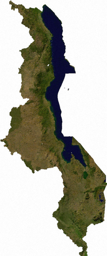 Satellite image of Malawi
 Topography of Malawi
Malawi is situated in southeastern Africa. It is wholly within the tropics; from about 9°30S at its northernmost point to about 17°S at the southernmost tip. The country occupies a thin strip of land in between Zambia and Mozambique protruding southwards into Mozambique along the valley of the Shire River. In the north and north east it also shares a border with Tanzania. Malawi is landlocked and is connected by rail to the Mozambican ports of Nacala and Beira.
Contents
Landscape
The Great Rift Valley traverses the country from north to south. In this deep trough lies Lake Malawi, the third-largest lake in Africa, comprising about 20% of Malawi's area. The Shire River flows from the south end of the lake and joins the Zambezi River 400 kilometers (249 mi) farther south in Mozambique.
West of the Great Rift Valley, the land forms high plateaus, generally between 900 and 1,200 meters (2,953 and 3,937 ft) above sea level. In the north, the Nyika Uplands rise as high as 2,600 meters (8,530 ft). The area to the west of the lake in northern and central Malawi has been categorised by the World Wildlife Fund as part of the Central Zambezian Miombo woodlands ecoregion.
South of the lake lie the Shire Highlands, with an elevation of 600–1,600 meters (1,969–5,249 ft), rising to elevations of 2,130 and 3,002 meters (6,988 and 9,849 ft) at the Zomba Plateau and Mulanje Massif respectively. In the extreme south, the elevation is only 60–90 meters (197–295 ft) above sea level.
Malawi is one of Sub-Saharan Africa's most densely populated countries. The population of Lilongwe—Malawi's capital since 1971—exceeds 400,000. All government ministries and the Parliament are located in Lilongwe. Blantyre, Malawi remains Malawi's major commercial center and largest city, having grown from an estimated 109,000 inhabitants in 1966 to nearly 500,000 in 1998. Malawi's President resides in Blantyre. The Supreme Court is seated in Blantyre.
Malawi has five national parks:
- Cape Maclear National Park
- Kasungu National Park
- Lengwe National Park
- Liwonde National Park
- Nyika National Park
Climate
Malawi's climate is generally tropical. A rainy season runs from November to April. There is little to no rainfall throughout much of the country from May to October. It is hot and humid from September to April along the lake and in the lower Shire Valley, with average daytime maxima around 27 to 29 °C (80.6 to 84.2 °F). Lilongwe is also hot and humid during these months, albeit far less than in the south. The rest of the country is warm during those months with a maximum temperature during the day around 25 °C (77 °F). From June through August, the lake areas and south are comfortably warm, with daytime maxima of around 23 °C (73.4 °F), but the rest of Malawi can be chilly at night, with temperatures ranging from 10–14 °C (50–57.2 °F). High altitude areas such as Mulanje and Nyika are often cold at night (around 6–8 °C / 42.8–46.4 °F) during June and July. Karonga in the far north shows little variation in temperature with maximum daytime temperature remaining around 25 to 26 °C (77 to 78.8 °F) all year round but is unusual in that April and May are the wettest times of the year due to strengthening southerly winds along the lake.
Area
The total area of the country is 118,480 km², but this includes 24,400 km² of water surface, mainly composed of Lake Malawi, but there are other sizeable lakes, such as Lake Malombe, Lake Chilwa and Lake Chiuta. The land area is 94,080 km².
The country is dominated by Lake Malawi, which drains into the Zambezi River through the Shire River. As a result the whole of the country, except for one eastern district is part of the Zambezi drainage system. Lake Chiuta and the surrounding plain is drained by the Lugenda river, which is part of the Ruvuma River drainage system. Lake Chilwa, about 35 km south of Lake Chiuta is unusual as it has no outlet although when it overflows it flows into Lake Chiuta through a swampy plain. High rates of evaporation ensure that the lake seldom fills up – much of the lake is only 1 metre deep or less.
Environment — current issues: Deforestation; land degradation; water pollution from agricultural runoff, sewage, industrial wastes; siltation of spawning grounds endangers fish populations
Environment — international agreements:
party to: Biodiversity, Climate Change, Desertification, Endangered Species, Environmental Modification, Hazardous Wastes, Marine Life Conservation, Nuclear Test Ban, Ozone Layer Protection, Wetlands
signed, but not ratified: Law of the SeaExtreme points
This is a list of the extreme points of Malawi, the points that are farther north, south, east or west than any other location.
- Northern-most point - the tripoint with Tanzania and Zambia, Northern Region
- Eastern-most point - unnamed location on the border with Mozambique immediately south-west of the Mozambican village of Buena-uzi, Southern Region
- Southern-most point - unnamed location on the border with Mozambique immediately north-east of the Mozambican village of Jossene, Southern Region
- Western-most point - unnamed location on the border with Zambia immediately east of the Zambian town of Chipata, Central Region
See also
Sovereign
states- Algeria
- Angola
- Benin
- Botswana
- Burkina Faso
- Burundi
- Cameroon
- Cape Verde
- Central African Republic
- Chad
- Comoros
- Democratic Republic of the Congo
- Republic of the Congo
- Côte d'Ivoire (Ivory Coast)
- Djibouti
- Egypt
- Equatorial Guinea
- Eritrea
- Ethiopia
- Gabon
- The Gambia
- Ghana
- Guinea
- Guinea-Bissau
- Kenya
- Lesotho
- Liberia
- Libya
- Madagascar
- Malawi
- Mali
- Mauritania
- Mauritius
- Morocco
- Mozambique
- Namibia
- Niger
- Nigeria
- Rwanda
- São Tomé and Príncipe
- Senegal
- Seychelles
- Sierra Leone
- Somalia
- South Africa
- South Sudan
- Sudan
- Swaziland
- Tanzania
- Togo
- Tunisia
- Uganda
- Zambia
- Zimbabwe
States with limited
recognition- Sahrawi Arab Democratic Republic
- Somaliland
Dependencies and
other territories- Canary Islands / Ceuta / Melilla / Plazas de soberanía (Spain)
- Madeira (Portugal)
- Mayotte / Réunion (France)
- Saint Helena / Ascension Island / Tristan da Cunha (United Kingdom)
- Western Sahara
Climate of Africa Sovereign
states- Algeria
- Angola
- Benin
- Botswana
- Burkina Faso
- Burundi
- Cameroon
- Cape Verde
- Central African Republic
- Chad
- Comoros
- Democratic Republic of the Congo
- Republic of the Congo
- Côte d'Ivoire (Ivory Coast)
- Djibouti
- Egypt
- Equatorial Guinea
- Eritrea
- Ethiopia
- Gabon
- The Gambia
- Ghana
- Guinea
- Guinea-Bissau
- Kenya
- Lesotho
- Liberia
- Libya
- Madagascar
- Malawi
- Mali
- Mauritania
- Mauritius
- Morocco
- Mozambique
- Namibia
- Niger
- Nigeria
- Rwanda
- São Tomé and Príncipe
- Senegal
- Seychelles
- Sierra Leone
- Somalia
- South Africa
- South Sudan
- Sudan
- Swaziland
- Tanzania
- Togo
- Tunisia
- Uganda
- Zambia
- Zimbabwe
States with limited
recognition- Sahrawi Arab Democratic Republic
- Somaliland
Dependencies and
other territories- Canary Islands / Ceuta / Melilla / Plazas de soberanía (Spain)
- Madeira (Portugal)
- Mayotte / Réunion (France)
- Saint Helena / Ascension Island / Tristan da Cunha (United Kingdom)
- Western Sahara
Categories:


Wikimedia Foundation. 2010.