- Chattenden and Upnor Railway
-
Coordinates: 51°25′05″N 0°31′48″E / 51.418°N 0.530°E
Chattenden and Upnor Railway Locale England Dates of operation 1873–1961 Track gauge 2 ft 6 in (762 mm) Headquarters Chattenden The Chattenden and Upnor Railway (later known as the Lodge Hill and Upnor Railway) was a narrow gauge railway serving the military barracks and depot at Upnor and associated munitions and training depots. It was built in 1873 as a 18 in (457 mm) gauge railway, converted to 2 ft 6 in (762 mm) gauge around 1885 and continued in use until 1961.
Contents
History
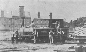 Locomotive Yorkshire beneath the barracks clock at Chattenden
The Chattenden and Upnor Railway was originally laid in 1873 to 18 in (457 mm) gauge, as a training exercise for the Royal School of Military Engineering which was then based at Chattenden. The line ran from Pontoon Hard by the River Medway and climbed steeply towards Chattenden. A spur lead from Church Crossing to the Upnor Depot of the Royal Engineers and until 1895 a branch ran from Chattenden to Hoo.
In 1885 the railway was relaid and converted to 2 ft 6 in (762 mm) gauge by the 8th. Railway Company of the Royal Engineers who managed the line. In 1891 the Admiralty took over Upnor Depot to use as a gun and ammunition store. Another armaments depot was constructed at Lodge Hill, north of Chattenden which was also served by the railway. In 1905 the entire Chattenden enclosure was taken over by the Navy, and in 1906 the railway was also taken over by the Navy and renamed the Lodge Hill and Upnor Railway. The Navy extended the line to connect with the standard gauge branch from Sharnal Street on the South Eastern & Chatham Railway's Hundred of Hoo branch.
The railway saw intensive use during the Second World War, but use declined after the end of hostilities and the railway closed in 1961.
Locomotives
Name/Number Builder Type Date Works number Notes Sulphur Yorkshire Engine Company 0-4-2T 1885 405 Sold for scrap by 1931 Carbon Yorkshire Engine Company 0-4-2T 1886 404 Scrapped by 1931 Cheshire W.G. Bagnall 0-4-2T 1890 1260 ex-War Department, Crewe. Sold for scrap 1931 or 1932 Lancashire Yorkshire Engine Company 0-4-4T 1891 462 Sold for scrap by 1932 Cumberland Lowca Engine Company 0-4-2T 1893 220 Scrapped by 1904 Eardley Wilmot W.G. Bagnall 0-6-0T 1897 1513 ex-War Department, South Africa, 1901. Scrapped by 1904 Bagnall W.G. Bagnall 0-6-0ST 1897 1514 ex-War Department, South Africa, 1901. Scrapped 1931 or 1932 Kitchener Yorkshire Engine Company 0-6-2T 1902 711 ex-War Department, Egypt. To Chatham Dockyard for scrap 1948; scrapped 1954. Yorkshire John Fowler 0-4-4T before 1897 5350 Scrapped 1931. Pioneer Yorkshire Engine Company 2-6-2PT 1904 757 To War Department, Woolmer Instructional Military Railway, 1905 Ascension Avonside Engine Company 0-4-2T 1904 1480 To Admiralty, Hoo Ness, by 1928. Fisher Dick Kerr and Company 0-6-2T 1915 13996 Scrapped 1954 Chevalier Manning Wardle 0-6-2T 1915 1677 Sold to the Bowaters Paper Railway in 1950, subsequently sold to the Great Whipsnade Railway Burnett Hall Avonside 0-4-2T 1933 2070 Scrapped 1956 Norbury Peckett 0-4-2T 1934 1868 Scrapped 1955 Hunslet 6wDM 1946 3301 Drewry 6wDM 1949 2263 Sold to the Welshpool and Llanfair Light Railway in 1968 and named Chattenden Hibberd Planet 4wDM 1954 3687 Sold to the Welshpool and Llanfair Light Railway in 1961, named Upnor Castle, sold to the Ffestiniog Railway and regauged to 1 ft 11 1⁄2 in (597 mm) 89 Greenwood & Batley BE Used for shunting ammunition wagons References
- Thomas, Cliff (2002). The Narrow Gauge in Britain & Ireland. Atlantic Publishers. ISBN 1-902827-05-8.
- Yeatan, D. (December 1966). "Lodge Hill and Upnor Railway". The Industrial Railway Record 12: 277–292.
- Mitchell, Vic and Smith, Keith (2000). Kent Narrow Gauge. Middleton Press. ISBN 1901706451.
See also
- British narrow gauge railways
- BBC Action Network: Reopen the railway? http://www.bbc.co.uk/dna/actionnetwork/F1602272?thread=2342475?s_returnto=c2301
- Industrial Railway Society http://www.irsociety.co.uk/Archives/12/lodge_hill.htm
Categories:- 2ft 6in gauge railways
- Industrial railways in England
- Transport in Medway
- Narrow gauge railways in England
- Rail transport in Kent

Wikimedia Foundation. 2010.