- Clinton County, Pennsylvania
-
Clinton County, Pennsylvania 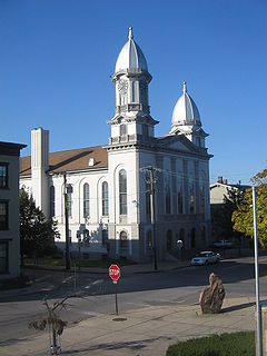
Clinton County Courthouse 
Location in the state of Pennsylvania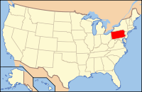
Pennsylvania's location in the U.S.Founded June 21, 1839 Seat Lock Haven Largest city Lock Haven Area
- Total
- Land
- Water
898 sq mi (2,326 km²)
891 sq mi (2,308 km²)
7 sq mi (18 km²), 0.81%Population
- (2010)
- Density
39,238
44/sq mi (17/km²)Website www.clintoncountypa.com Clinton County is a county located in the U.S. state of Pennsylvania. As of 2010, the population was 39,238. It is included in the Lock Haven, Pennsylvania, Micropolitan Statistical Area. Its name is in honor of the seventh Governor of New York State, DeWitt Clinton. It was created on June 21, 1839, from parts of Centre and Lycoming Counties. Its county seat is at Lock Haven[1].
Contents
Government and politics
As of November 2008, there were 22,997 registered voters in Clinton County [1].
- Democratic: 10,829 (47.09%)
- Republican: 9,640 (41.92%)
- Other Parties: 2,528 (10.99%)
While Clinton County has historically been Republican like the rest of central Pennsylvania, Democrats captured the registration edge in early 2008. Each of the three row-office statewide winners carried Clinton in 2008. In 2006, Democrat Bob Casey Jr. received 54% of its vote when he unseated incumbent Republican US Senator Rick Santorum and Ed Rendell received 56% of the vote against Lynn Swann.
County commissioners
- Jeffrey Snyder, Chairman, Republican
- Pete Smeltz, Republican
- Adam C. Coleman, Vice Chaiman, Democrat
Other county offices
- Chief Clerk, Amy G. Dicello
- Clerk of Courts and Prothonotary, Marie Vilello , Republican
- District Attorney, Michael Salisbury, Republican
- Register of Wills, Gail Gephart, Republican
- Treasurer, Patricia Edwards, Republican
Pennsylvania State Senate
District Senator Party 35 John Wozniak Democrat Pennsylvania House of Representatives
District Representative Party 76 Mike Hanna Democrat United States House of Representatives
District Representative Party 5 Glenn "G.T." Thompson Republican United States Senate
Senator Party Pat Toomey Republican Bob Casey Democrat Geography
According to the U.S. Census Bureau, the county has a total area of 898 square miles (2,330 km2) of which 891 square miles (2,310 km2) is land and 7 square miles (18 km2) (0.81%) is water.
Adjacent counties
- Potter County (north)
- Lycoming County (east)
- Union County (southeast)
- Centre County (south)
- Clearfield County (southwest)
- Cameron County (west)
Demographics
Historical populations Census Pop. %± 1840 8,323 — 1850 11,207 34.7% 1860 17,723 58.1% 1870 23,211 31.0% 1880 26,278 13.2% 1890 28,685 9.2% 1900 29,197 1.8% 1910 31,545 8.0% 1920 33,555 6.4% 1930 32,319 −3.7% 1940 34,557 6.9% 1950 36,532 5.7% 1960 37,619 3.0% 1970 37,721 0.3% 1980 38,971 3.3% 1990 37,182 −4.6% 2000 37,910 2.0% 2010 39,238 3.5% [2][3] As of the census[4] of 2000, there were 37,914 people, 14,773 households, and 9,927 families residing in the county. The population density was 43 people per square mile (16/km²). There were 18,166 housing units at an average density of 20 per square mile (8/km²). The racial makeup of the county was 98.29% White, 0.52% Black or African American, 0.11% Native American, 0.40% Asian, 0.02% Pacific Islander, 0.15% from other races, and 0.52% from two or more races. 0.54% of the population were Hispanic or Latino of any race. 36.0% were of German, 15.6% American, 9.6% Irish, 8.6% Italian and 7.4% English ancestry according to Census 2000.
There were 14,773 households out of which 27.70% had children under the age of 18 living with them, 54.00% were married couples living together, 9.40% had a female householder with no husband present, and 32.80% were non-families. 26.60% of all households were made up of individuals and 13.60% had someone living alone who was 65 years of age or older. The average household size was 2.42 and the average family size was 2.90.
In the county, the population was spread out with 21.50% under the age of 18, 13.60% from 18 to 24, 25.50% from 25 to 44, 22.70% from 45 to 64, and 16.80% who were 65 years of age or older. The median age was 38 years. For every 100 females there were 94.20 males. For every 100 females age 18 and over, there were 91.20 males.
Municipalities
 Map of Clinton County, Pennsylvania with Municipal Labels showing Cities and Boroughs (red), Townships (white), and Census-designated places (blue).
Under Pennsylvania law, there are four types of incorporated municipalities: cities, boroughs, townships, and, in at most two cases, towns. The following cities, boroughs and townships are located in Clinton County:
Cities
Boroughs
Townships
- Allison Township
- Bald Eagle Township
- Beech Creek Township
- Castanea Township
- Chapman Township
- Colebrook Township
- Crawford Township
- Dunnstable Township
- East Keating Township
- Gallagher Township
- Greene Township
- Grugan Township
- Lamar Township
- Leidy Township
- Logan Township
- Noyes Township
- Pine Creek Township
- Porter Township
- Wayne Township
- West Keating Township
- Woodward Township
Census-designated places
Census-designated places are geographical areas designated by the U.S. Census Bureau for the purposes of compiling demographic data. They are not actual jurisdictions under Pennsylvania law. Other unincorporated communities, such as villages, may be listed here as well.
 Map of Clinton County, Pennsylvania Public School Districts
Education
Colleges and universities
Public School Districts
- Jersey Shore Area School District (also in Lycoming County)
- Keystone Central School District (also in Centre County)
- West Branch Area School District (also in Clearfield County)
Recreation
There are five Pennsylvania state parks in Clinton County.
- Bucktail State Park Natural Area is a 75-mile (121 km) scenic route along Pennsylvania Route 120 stretching from Lock Haven to Emporium in Cameron County.
- Hyner Run State Park
- Hyner View State Park
- Kettle Creek State Park
- Ravensburg State Park
Coordinates: 41°14′N 77°38′W / 41.24°N 77.64°W
See also
- List of municipal authorities in Clinton County, Pennsylvania
- National Register of Historic Places listings in Clinton County, Pennsylvania
References
- ^ "Find a County". National Association of Counties. http://www.naco.org/Counties/Pages/FindACounty.aspx. Retrieved 2011-06-07.
- ^ http://factfinder2.census.gov
- ^ http://mapserver.lib.virginia.edu/
- ^ "American FactFinder". United States Census Bureau. http://factfinder.census.gov. Retrieved 2008-01-31.
External links
Municipalities and communities of Clinton County, Pennsylvania City 
Boroughs Avis | Beech Creek | Flemington | Loganton | Mill Hall | Renovo | South Renovo
Townships CDPs Unincorporated
communitiesKeating | Westport
Footnotes ‡This populated place also has portions in an adjacent county
Categories:- Pennsylvania counties
- Clinton County, Pennsylvania
- 1839 establishments in the United States
- Populated places established in 1839


Wikimedia Foundation. 2010.