- Clyde Arc
-
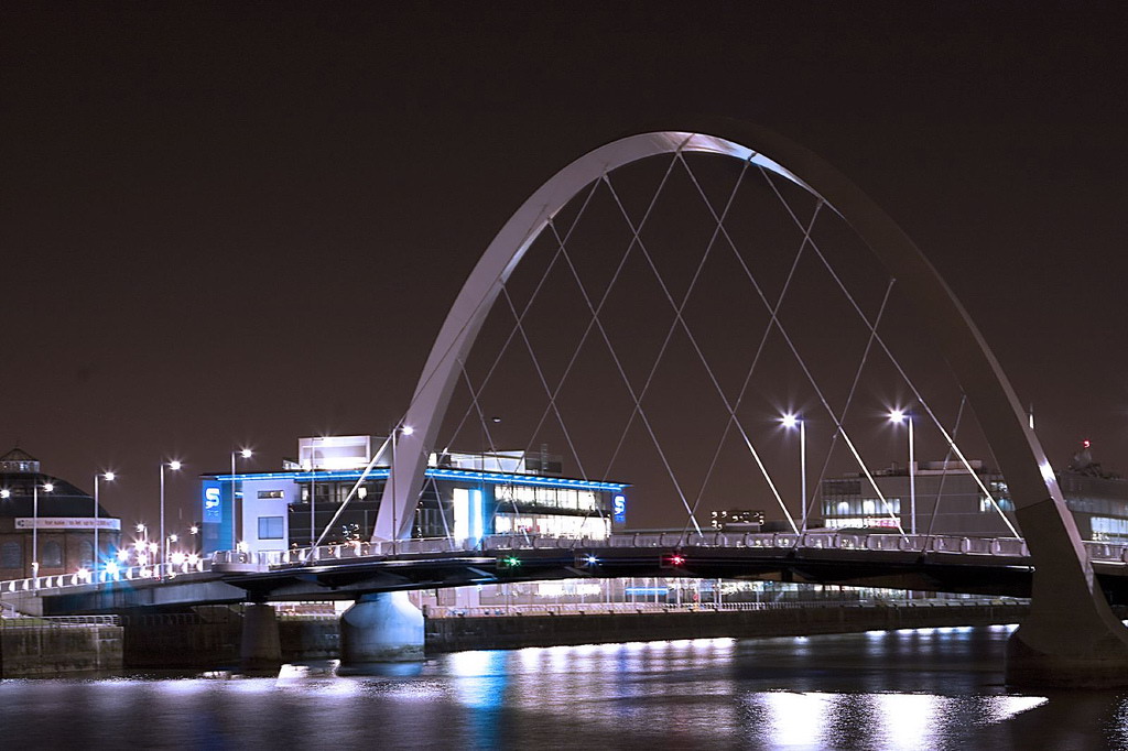
Clyde Arc 
View of the Clyde Arc from the EastOfficial name Clyde Arc Carries Motor vehicles, cyclists and pedestrians Crosses River Clyde Locale Glasgow, Scotland Width Dual two-lane carriageway, two cycle/footpaths (total width 22m) Longest span 96m Opened 18 September 2006 Toll Free Coordinates 55°51′26″N 4°16′57″W / 55.85722°N 4.2825°W  Clyde Arc
The Clyde Arc (known locally as the Squinty Bridge), is a road bridge spanning the River Clyde in Glasgow, in west central Scotland, connecting Finnieston, near the Clyde Auditorium and SECC with Pacific Quay and Glasgow Science Centre in Govan. A prominent feature of the bridge is its innovative curved design and the way that it crosses the river at an angle. The Arc is the first city centre traffic crossing over the river built since the Kingston Bridge was opened to traffic in 1969.
The bridge was named the "Clyde Arc" upon its official opening on 18 September 2006. It has been previously known as the "Finnieston Bridge" or the "Squinty Bridge".[1]
Contents
Design
The bridge was designed by the Halcrow Group and built by Kilsyth-based civil engineering company Edmund Nuttall. Glasgow City Council instigated the project in conjunction with Scottish Enterprise and the Scottish Executive. Piling works for the bridge were carried out from a large floating barge on the Clyde, whilst the bridge superstructure was fabricated offsite. The bridge-deck concrete-slab units were cast at an onsite pre-casting yard. Planning permission was granted in 2003 and construction of the bridge began in May 2005. It was structurally completed in April 2006. The bridge project cost an estimated £20.3m.[2] The Bridge is designed to last 120 years.[3]
The bridge has a main span of 96 m with two end spans of 36.5 m (total 169 m). The design of the main span features a steel bowstring asymmetric tied arch. The supports for the main span are located within the river with the abutments located behind the existing quay walls. The central navigation height at mean water height is 5.4 m.
It was officially opened on 18 September 2006 by Glasgow City Council leader Steven Purcell, although pedestrians were allowed to walk across it the previous two days as part of Glasgow's annual "Doors Open" Weekend.
The bridge connects Finnieston Street on the north bank of the river to Govan Road on the southern bank. The bridge takes four lanes of traffic, two of which are dedicated to public transport and two for private and commercial traffic. There are also pedestrian and cycle paths. The new bridge was built to provide better access to Pacific Quay and allow better access to regeneration areas on both banks of the Clyde. The bridge has been designed to cope with a possible light rapid transit system (light railway scheme) or even a tram system.
The bridge is the first part of a massive development project planned to regenerate Glasgow. There are two more bridges planned - the £40m Tradeston bridge and a further pedestrian bridge linking Springfield Quay with Lancefield Quay on the north bank. The canting basin and graving dock next to Pacific Quay are to be developed along with Tradeston and Laurieston. Plans are afoot to transform Rutherglen and Dalmarnock as the 'athletes' village' for the 2014 Commonwealth Games in Glasgow.[4]
Support hanger failure
The bridge was closed between 14 January and 28 June 2008 due to the failure of one support hanger, and cracks found in a second.
On the night of 14 January 2008 the connecting fork on one of the bridge's 14 hangers (supporting cables that transfer the weight of the roadway to the bridge's arch) snapped; Strathclyde Police quickly closed the bridge to traffic.[5] Robert Booth, a spokesman for Glasgow City Council said:
“ We don't believe the integrity of the bridge is affected. The Clyde Arc is designed to allow for the removal of one of the bridge supports at a time for repair and maintenance without affecting its operation. However, our number one priority is public safety and until we are completely satisfied the bridge is safe to use, it will remain closed. ” A detailed inspection on 24 January found a stress fracture in a second support cable stay, like the one which had failed previously. Engineers determined that all of these connectors would have to be replaced; rather than a brief closure the bridge would have to remain closed for six months.[6] In addition traffic on the river below was also halted.[7] In March Nuttall began installing five temporary saddle frames atop the bridge's arch; these allowed the weight of the bridge to be supported without the hangers. This allowed them to replace defective fork connectors at the top and bottom of each hanger.[6]
The bridge reopened on 28 June 2008 with just two of its four lanes in use, having had all the cast steel connectors replaced with milled steel connectors.[8] Once reopened Glasgow council estimated that 6500 crossings will be made every day using the bridge.[9]
On 8 January 2009, New Civil Engineer reported that subcontractor Watson Steel was suing Macalloy, the supplier of the suspect connectors, for £1.8 million.[citation needed]
According to reports, Watson alleges steel obtained from Macalloy did not meet British Standards or their own specifications; parts were inadequately manufactured, and did not tally with test certificates provided by the firm.[citation needed]
References
- ^ "Evening Times" [1]. 2006. Accessed 18 September 2006.
- ^ "Road Traffic Technology" [2]. 2006. Accessed Sept 18th, 2006.
- ^ "Public will not foot bridge bill". BBC News. 2008-01-25. http://news.bbc.co.uk/1/hi/scotland/glasgow_and_west/7208575.stm. Retrieved 2008-01-29.
- ^ "The Glasgow Herald" [3]. 2006. Accessed Sept 18th, 2006.
- ^ "Clyde Arc closed by cable 'snap'". BBC Scotland. 2008-01-15. http://news.bbc.co.uk/1/hi/scotland/glasgow_and_west/7188577.stm. Retrieved 2008-01-15.
- ^ a b "Sitting pretty in Glasgow", p3 Construction News Issue 7060, 20 March 2008
- ^ "Second fault on 'Squinty Bridge'". BBC Scotland News. 2008-01-24. http://news.bbc.co.uk/1/hi/scotland/glasgow_and_west/7207693.stm. Retrieved 2008-01-24.
- ^ "Clyde Arc reopens after repairs". BBC News. 2008-06-29. http://news.bbc.co.uk/1/hi/scotland/glasgow_and_west/7477405.stm. Retrieved 2008-06-30.
- ^ "Date for 'Squinty Bridge' opening". BBC. 2008-06-04. http://news.bbc.co.uk/1/hi/scotland/glasgow_and_west/7437386.stm. Retrieved 2008-06-04.
External links
River Clyde, Scotland Administrative areas Flows into Firth of Clyde, then North ChannelTowns
(upstream to downstream)Elvanfoot · Abington · Symington · New Lanark · Lanark · Wishaw · Motherwell · Hamilton · Bothwell · Uddingston · Rutherglen · Glasgow · Renfrew · Clydebank · Bearsden · Old Kilpatrick · Dumbarton · Port Glasgow · Greenock · Helensburgh · Gourock · DunoonMajor tributaries
(upstream to downstream by confluence)Daer Water · Potrail Water · Duneaton Water · Medwin Water · Douglas Water · Mouse Water · River Nethan · Avon Water · South Calder Water · North Calder Water · River Kelvin · River Cart · River LevenMajor bridges
(upstream to downstream)Garrion Bridge · Dalmarnock Bridge · Dalmarnock Railway Bridge · Rutherglen Bridge · Polmadie Bridge · King's Bridge · St. Andrew's Suspension Bridge · Pipe Bridge and Weir · Albert Bridge · City Union Bridge · Victoria Bridge · South Portland Street Suspension Bridge · Glasgow Bridge · Caledonian Railway Bridge · George V Bridge · Tradeston Bridge · Kingston Bridge · Clyde Arc · Bell's Bridge · Millennium Bridge · Erskine Bridge
Categories:- Bridges in Glasgow
- Bridges completed in 2006
- Engineering failures
- Govan
- Pedestrian bridges in Scotland
- Tied arch bridges

Wikimedia Foundation. 2010.