- Chatfield Hollow State Park
-
Chatfield Hollow State Park 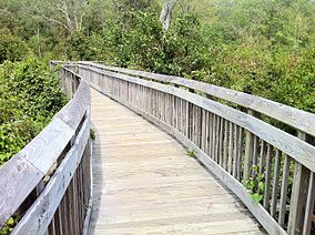
Chatfield Hollow State Park - "Paul F. Wildermann Boardwalk".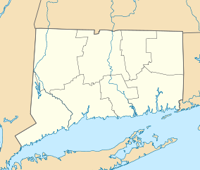
 Chatfield Hollow State Park
Location Killingworth, Connecticut Nearest city Killingworth, Connecticut, United States Coordinates 41°22′14″N 72°36′1″W / 41.37056°N 72.60028°WCoordinates: 41°22′14″N 72°36′1″W / 41.37056°N 72.60028°W Area 356 acres (1.44 km2) Established 1949 Governing body State of Connecticut Department of Energy and Environmental Protection (CT DEEP) Official website Chatfield Hollow State Park is a state park of the U.S. state of Connecticut, located in Killingworth, Connecticut. There are trails in the park, a lake beach and a stream. There is trout fishing in the state park, as well as Indian Caves, hiking, birdwatching, historic sites, mountain biking, rock climbing, and picnicking areas. One of the park's attractions is a water wheel. The park is 356 acres (1.4 km²) in size.
Contents
Recreation
 Chatfield Hollow State Park - northern terminus for both the Orange Deep Woods and Blue West Crest trails.
Hiking
There are approximately 20 miles of hiking trails that originate within the park and extend into an adjacent section of Cockaponset State Forest. This includes the Chatfield Trail, a part of the Blue-Blazed hiking trail network. Hiking in this area is rugged at times with many rock outcroppings and roots making this a scenic terrain. There is also a scenic boardwalk constructed over a swamp that makes for interesting and educational hiking.
Mountain Biking
Technical cross-country mountain biking is also a popular recreational pursuit along some of the most difficult trails in the state. Among the most difficult are the Lookout Trail, and the Pond Trail which is a side trail that loops off the Deep Woods Trail.
Rock Climbing
There are several ledges and cliffs throughout the park with one of the most popular rock climbing routes in the state along the southern end of the Deep Woods Trail adjacent to RT 80.
Trout Fishing
Chatfield Hollow State Park is one of Connecticut's eleven Trout Parks. It gets special attention from the Connecticut DEEP with stockings on opening day as well as throughout the season. The best time to fish the Trout Parks is the period between opening day and Memorial day. The ponds and streams at Chatfield Hollow are easily accessible to make the experience ideal for young and novice anglers.[1]
References
- ^ "DEP Trout Parks". http://www.ct.gov/dep/cwp/view.asp?a=2696&q=322724&depNav_GID=1630. Retrieved 2007-06-22.
External links
- Chatfield Hollow State Park - official site
Protected areas of Connecticut National Park Service National Wildlife Refuges Silvio O. Conte • Stewart B. McKinney National Wildlife Refuge
National Trails State Parks Airline • Beckley Iron Furnace Industrial Monument • Bigelow Hollow • Black Rock • Bluff Point • Burr Pond • Camp Columbia • Campbell Falls • Chatfield Hollow • Collis P. Huntington • Connecticut Valley Railroad • Day Pond • Dennis Hill • Devil's Hopyard • Dinosaur • Fort Griswold Battlefield • Fort Trumbull • Gardner Lake • Gay City • George W. Seymour • Gillette Castle • Haddam Meadows • Haley Farm • Hammonasset Beach • Hampton Beach • Harkness Memorial • Haystack Mountain • Hop River State Park Trail • Hopeville Pond • Housatonic Meadows • Hurd • Indian Well • John A. Minetto • Kent Falls • Kettletown • Lake Waramaug • Larkin State Park Trail • Levy • Lovers Leap • Macedonia Brook • Mansfield Hollow • Mashamoquet Brook • Millers Pond • Mohawk Mountain • Moosup Valley State Park Trail • Mount Tom • Old Furnace • Osbornedale • Penwood • Putnam Memorial • Quaddick • Quinnipiac River • River Highlands • Rocky Neck • Selden Neck • Seth Low Pierrepont • Sherwood Island • Silver Sands • Sleeping Giant • Southford Falls • Squantz Pond • Stratton Brook • Talcott Mountain • Wadsworth Falls • West Rock Ridge • Wharton Brook • Windsor Locks Canal State Park Trail
State Forests Algonquin • American Legion • Centennial Watershed • Cockaponset • Enders • James L. Goodwin • Housatonic • Massacoe • Mattatuck • Meshomasic • Mohawk • Mohegan • Nassahegon • Natchaug • Nathan Hale • Nehantic • Nepaug • Nipmuck • Nye-Holman • Pachaug • Paugnut • People's • Pootatuck • Quaddick • Salmon River • Shenipsit • Topsmead • Tunxis • Wyantenock
Connecticut Department of Environmental Protection (web)Hiking Trails in Connecticut Airline State Park Trail • Alain and May White Trails • American Legion • Appalachian Trail • Aspetuck Valley • Bigelow Hollow • Case Mountain • Charter Oak Greenway • Chatfield • Cockaponset • East Coast Greenway • Falls Brook • Farmington Canal Heritage Trail • Gay City • Hancock Brook • Hop River State Park Trail • Housatonic Range • Jericho • Kettletown • Lillinonah • Lone Pine • Macedonia Brook • Mattabesett • Mattatuck • McLean Game Refuge • Menunkatuck • Metacomet • Mohawk • Moosup Valley State Park Trail • Muir • Narragansett • Natchaug • Naugatuck • Nayantaquit • Nehantic • New England National Scenic Trail • Nipmuck • Old Furnace • Patchaug • Paugussett • Peoples • Pequot • Pine Knob • Pomperaug • Quinebaug • Quinnipiac • Ragged Mountain • Regicides • Salmon River • Saugatuck • Shenipsit • Sleeping Giant • Sleeping Giant State Park • Stony Creek Quarry • Sunny Valley Preserve • Tunxis • Washington–Rochambeau Revolutionary Route • Westwoods • Whitestone Cliffs • Wolcott Trail • Zoar
 Categories:
- Killingworth, Connecticut
- Connecticut state parks
- Parks in Middlesex County, Connecticut
- Climbing areas of the United States
- Mountain biking venues in the United States
- Hiking trails in Connecticut


Wikimedia Foundation. 2010.