- Charlotte Amalie, United States Virgin Islands
-
Charlotte Amalie, United States Virgin Islands Charlotte Amalie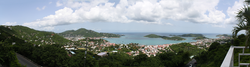


Coordinates: 18°21′N 64°57′W / 18.35°N 64.95°W Country U.S. Virgin Islands Island Saint Thomas Population (2000) - Total 18,914 ZIP code 00801–00804 Area code(s) 340 Charlotte Amalie (pronounced /ˈʃɑrlət əˈmɑːljə/ or -/ˈæməliː/) is the capital and largest city of the U.S. Virgin Islands. It is located on the island of Saint Thomas and as of 2004 had an estimated population of 19,000 (the 2000 U.S. Census found a population of 18,914).[1]
The city is named after Charlotte Amalie of Hesse-Kassel (or Hessen-Cassel) (1650–1714), queen consort to King Christian V of Denmark. It is famous as a deep-water harbor that was once a haven for pirates and is now a famed cruise ship port of call, with about 1.5 million cruise ship passengers landing there in 2004. Charlotte Amalie has many buildings of historical importance and is home to St. Thomas Synagogue, the second-oldest synagogue in the Western Hemisphere.[citation needed]
Contents
Transportation
Highway 30 (Veterans Dr) passes through Charlotte Amalie. Additionally, Charlotte Amalie holds one of two airports in the US Virgin Islands. Cyril E. King Airport (IATA: STT ICAO: TIST) offers regular nonstop service to many destinations along the east coast of the United States.
Geography
Charlotte Amalie sits on the south part of Saint Thomas next to Water Island.
Climate
Charlotte Amalie features a tropical wet and dry climate. The city has a short dry season that covers from January through March and a wet season that covers the remaining nine months, though technically June, with a monthly average precipitation of 2.35 in (59.7 mm) could be considered a dry season month. While Charlotte Amalie does have a lengthy wet season, outside the months of September through November, the city generally does not see the heavy precipitation that is prevalent in many other cities with a tropical climate. The city is generally very warm and humid. Average temperatures in Charlotte Amalie are at a near constant, with average high temperatures at about 88°F and average low temperatures at about 75°F.
Climate data for Charlotte Amalie Month Jan Feb Mar Apr May Jun Jul Aug Sep Oct Nov Dec Year Average high °F (°C) 86
(30)86
(30)86
(30)88
(31)88
(31)90
(32)90
(32)91
(33)90
(32)90
(32)88
(31)86
(30)88.3
(31.3)Average low °F (°C) 72
(22)72
(22)72
(22)74
(23)76
(24)77
(25)78
(26)78
(26)77
(25)76
(24)75
(24)73
(23)75.0
(23.9)Precipitation inches (mm) 1.89
(48)1.51
(38.4)1.52
(38.6)2.39
(60.7)3.36
(85.3)2.35
(59.7)2.42
(61.5)3.50
(88.9)5.34
(135.6)5.57
(141.5)5.28
(134.1)2.74
(69.6)37.87
(961.9)Source: [2] Education
St. Thomas-St. John School District serves the community.
Addelita Cancryn Junior High School and Charlotte Amalie High School serve the area.
Gallery
 City view. Charlotte Amalie, St. Thomas, US Virgin Islands.
 One of the steep streets on the hillsides, Charlotte Amalie, St. Thomas, Virgin Islands.
See also
- Anna's Retreat
- Cruz Bay
- Saint Thomas
- Water Island
References
- ^ Census Bureau Releases Census 2000 Population Counts for the U.S. Virgin Islands, U.S. Census Bureau, July 3, 2001
- ^ "Monthly Averages for Saint Thomas, VI (00801)". The Weather Channel. http://www.weather.com/outlook/travel/businesstraveler/wxclimatology/monthly/00801. Retrieved May 13, 2009.
External links
- GoTo St Thomas
- ViNow
- Official Website of St. Thomas and St. John This Week Magazine – Tourist Information for St. Thomas and St. John
- Official Website of St. Croix This Week Magazine – Tourist Information for St. Croix
 Territory of United States Virgin IslandsCharlotte Amalie (capital)
Topics - Geography
- Economy
- Demographics
- Communications
- Transportation
- History
- Visitor Attractions
Government - Politics
- Governors
- Congressional Delegates
- Senators
- Elections
Cities - Charlotte Amalie
- Charlotte Amalie West
- Christiansted
- Frederiksted
- Cruz Bay
- Anna's Retreat
Islands Parks State capitals of the United States AL Montgomery AK Juneau AZ Phoenix AR Little Rock CA Sacramento CO Denver CT Hartford DE Dover FL Tallahassee GA Atlanta HI Honolulu ID Boise IL Springfield IN Indianapolis IA Des Moines KS Topeka KY Frankfort LA Baton Rouge ME Augusta MD Annapolis MA Boston MI Lansing MN Saint Paul MS Jackson MO Jefferson City MT Helena NE Lincoln NV Carson City NH Concord NJ Trenton NM Santa Fe NY Albany NC Raleigh ND Bismarck OH Columbus OK Oklahoma City OR Salem PA Harrisburg RI Providence SC Columbia SD Pierre TN Nashville TX Austin UT Salt Lake City VT Montpelier VA Richmond WA Olympia WV Charleston WI Madison WY Cheyenne DC Washington1
Territories:AS Pago Pago GU Hagåtña MP Saipan PR San Juan VI Charlotte Amalie Categories:- Capitals in North America
- Capitals of political divisions in the United States
- Capitals in the Caribbean
- Populated places in the United States Virgin Islands
- Port cities in the Caribbean
- Saint Thomas, U.S. Virgin Islands


Wikimedia Foundation. 2010.