- Provinces of the Netherlands
-
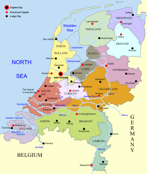 Map of the Netherlands, linking to the province articles; red dots mark provincial capitals and black dots other notable cities or towns.
Netherlands 
This article is part of the series:
Politics and government of
the NetherlandsConstitutionCabinetDecentralized gov'tForeign policyRelated subjects
A Dutch province represents the administrative layer in between the national government and the local municipalities, having the responsibility for matters of subnational or regional importance. The government of each province consists of three major parts: the Provinciale Staten which is the provincial parliament elected every four years. Elected from its members are the Gedeputeerde Staten, a college charged with most executive tasks, presided by the Commissaris van de Koningin appointed by the Crown.
Contents
Division
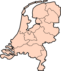
The modern-day Netherlands is divided into twelve provinces (provincies in Dutch).
Regions and their capitals
The twelve provinces are listed below with their capital city:
Flag Arms Province Dutch name Capital Queen's Commissioner Area
(km²)Population Density
(per km²)

Drenthe Drenthe Assen Jacques Tichelaar 2,652 482,300 182 

Flevoland Flevoland Lelystad Leen Verbeek 1,426 356,400 250 

Friesland Friesland / Fryslân (West Frisian) Leeuwarden John Jorritsma 3,361 642,500 191 

Gelderland Gelderland Arnhem Clemens Cornielje 4,995 1,967,600 394 

Groningen Groningen Groningen Max van den Berg 2,344 575,900 246 

Limburg Limburg Maastricht Léon Frissen (styled governor in Limburg) 2,167 1,143,000 527 

North Brabant Noord-Brabant 's-Hertogenbosch[A] Wim van de Donk 4,938 2,406,900 487 

North Holland Noord-Holland Haarlem Johan Remkes 2,660 2,583,900 971 

Overijssel Overijssel Zwolle Ank Bijleveld 3,337 1,105,800 331 

South Holland Zuid-Holland The Hague[B] Jan Franssen 2,860 3,453,000 1,207 

Utrecht Utrecht Utrecht Roel Robbertsen 1,356 1,159,200 855 

Zeeland Zeeland Middelburg Karla Peijs 1,792 378,300 211 - ^ Also, though not officially, abbreviated as Den Bosch.
- ^ Dutch: Den Haag, officially also: 's-Gravenhage.
Public bodies of the Netherlands
The three public bodies of the Bonaire, Sint Eustatius and Saba, became part of the Netherlands proper on October 10, 2010, but are not part of any province.[1]
Flag Arms Public Body Dutch name Capital Area
(km²)[2]Population[3] Density
(per km²)

Bonaire Bonaire / Boneiru (Papiamento) Kralendijk 294 15,414 52 

Sint Eustatius Sint Eustatius Oranjestad 21 3,300 157 

Saba Saba The Bottom 13 2,000 154 Historical background
 Flags of the provinces at the Binnenhof Hofvijver, The Hague
Nearly all Dutch provinces can trace their origin to a medieval state, such as a county or a duchy, as can the provinces of regions in Belgium. Their status changed when they came under a single ruler who centralised their administration, somewhat relegating the separate states to provinces, 17 in total. From these unified Netherlands, seven northern provinces would form the Republic of the Seven United Provinces in the 17th century, namely Holland, Zeeland, Gelderland, Utrecht, Friesland, Overijssel and Groningen. The Republic's lands also included Drenthe (one of the 17, but without the autonomous status of the others), and parts of Brabant, Limburg and Flanders, which were considered to be "conquered lands" and were governed directly by the Staten-Generaal, the parliament, hence their name Generality Lands. They were called Staats-Brabant, Staats-Limburg and Staats-Vlaanderen, meaning "state-owned". Each of these "Netherlands" had a high degree of autonomy, co-operating with each other mainly on defense and on the international level in general, but keeping to their own affairs elsewhere.
On January 1, 1796, during the Batavian Republic, Drenthe and Staats-Brabant became the eighth and ninth provinces of the Netherlands; the latter known as Bataafs Brabant, Batavian Brabant, changing its name to Noord Brabant, North Brabant, in 1815 when it became part of the United Kingdom of the Netherlands, which also contained (then) South Brabant, a province in Belgium. This new unified state featured the provinces in their modern form, as non-autonomous subdivisions of the national state, and again numbering 17 provinces, though not all the same as the 16th century ones. In 1839, with the independence of Belgium, the original single province of Limburg was divided amongst the two countries, each now having a province called Limburg. A year later, Holland, the largest and most populous of the Dutch provinces, was also split into two provinces for a total of 11. The 12th member was to be Flevoland, a province consisting almost entirely of reclaimed land, established on January 1, 1986.
The Departments of the French Period
During the Batavian Republic, the Netherlands was from 1798 to 1801 completely reorganised into eight new departments, most named after rivers, inspired by the French revolutionary example, in an attempt to do away with the old semi-autonomous status of the provinces. They are listed below, with their capitals and the territory of the former provinces that they mostly incorporated:
Batavian Departments English name Dutch name Capital Contained the territory of Department of the Ems Departement van de Eems Leeuwarden Northern Friesland, Groningen Department of the Old IJssel Departement van de Oude IJssel Zwolle Southern Friesland, Drenthe, Overijssel, Northern Gelderland Department of the Rhine Departement van de Rijn Arnhem Central Gelderland, eastern Utrecht Department of the Amstel Departement van de Amstel Amsterdam The area around Amsterdam Department of Texel Departement van Texel Alkmaar Northern Holland minus Amsterdam, northwestern Utrecht Department of the Delft Departement van de Delft Delft Southern Holland up to the Meuse, southwestern Utrecht Department of the Dommel Departement van de Dommel 's-Hertogenbosch The eastern part of Batavian Brabant, southern Gelderland Department of the Scheldt and Meuse Departement van de Schelde en Maas Middelburg Zeeland, Holland south of the Meuse and the western part of Batavian Brabant After only three years, following a coup d'etat, the borders of the former provinces were restored, though not their autonomous status. They were now also called "departments" and Drenthe was added to Overijssel. In 1806 the Kingdom of Holland replaced the republic to further French interests. It was during this administration that Holland was first split in two, with the department of Amstelland to the north and that of Maasland to the south. East Frisia, then as now in Germany, was added to the kingdom as a department in 1807 and Drenthe split off again making a total of 11 departments.
 Map of the subdivisions of the Netherlands during French administration. Note that East Frisia is not included in this (later) map.
When the Netherlands finally did become fully part of France in 1810, the departments of the kingdom and their borders were largely maintained, with some joined together. They were however nearly all renamed, again mainly after rivers, though the names differed from their Batavian counterparts. Following are their names and the modern day province they corresponded for the most part to:
French Departments in the Netherlands English name French name Dutch name Modern province(s) Department of the Zuiderzee Département du Zuyderzée Departement van de Zuiderzee North Holland & Utrecht Department of the Mouths of the Meuse Département des Bouches-de-la-Meuse Departement van de Monden van de Maas South Holland Department of the Mouths of the Scheldt Département des Bouches-de-l'Escaut Departement van de Monden van de Schelde Zeeland Department of the Two Nethes Département des Deux-Nèthes Departement van de Twee Nethen Western North Brabant & Antwerp Department of the Mouths of the Rhine Département des Bouches-du-Rhin Departement van de Monden van de Rijn Eastern North Brabant & southern Gelderland Department of the Upper IJssel Département de l'Yssel-Supérieur Departement van de Boven IJssel Northern Gelderland Department of the Mouths of the IJssel Département des Bouches-de-l'Yssel Departement van de Monden van de IJssel Overijssel Department of Frisia Département de la Frise Departement Friesland Friesland Department of the Western Ems Département de l'Ems-Occidental Departement van de Wester Eems Groningen & Drenthe Department of the Eastern Ems Département de l'Ems-Oriental Departement van de Ooster Eems (East-Frisia) With the defeat and withdrawal of the French in 1813, the old provinces and their names were re-established, Holland was reunited and East-Frisia went its separate way. The 17 provinces of the United Kingdom of the Netherlands were for a significant part based on the former French departments and their borders, in particular in what would later become Belgium.
See also
- ISO 3166-2:NL
- Table of administrative divisions by country
- Ranked list of Dutch provinces
- Flags of provinces of the Netherlands
- Coats of arms of provinces of the Netherlands
- Provincial politics in the Netherlands
References
- ^ "31.954, Wet openbare lichamen Bonaire, Sint Eustatius en Saba" (in Dutch). Eerste kamer der Staten-Generaal. http://www.eerstekamer.nl/wetsvoorstel/31954_wet_openbare_lichamen. Retrieved 2010-10-15. "De openbare lichamen vallen rechtstreeks onder het Rijk omdat zij geen deel uitmaken van een provincie. (The public bodies (...), because they are not part of a Province)."
- ^ "Regionale Kerncijfers Nederland" (in Dutch). Statistics Netherlands. 2007. http://statline.cbs.nl/StatWeb/publication/?VW=T&DM=SLNL&PA=70072ned&D1=224&D2=5-16&D3=l&HD=081103-1603&HDR=T&STB=G1,G2. Retrieved 2007-10-13.
- ^ "Bevolking per regio naar leeftijd, geslacht en burgerlijke staat" (in Dutch). Statistics Netherlands. 2007. http://statline.cbs.nl/StatWeb/publication/?VW=T&DM=SLNL&PA=03759ned&D1=0&D2=802-813&D3=0&D4=l&HD=081103-1603. Retrieved 2007-10-13.
External links
- Population and area figures
- Basic data for each province, with links to official province sites
- Provinces of the Netherlands at statoids.com
- Municipality data by province
 Provinces of the NetherlandsProvinces
Drenthe · Flevoland · Friesland · Gelderland · Groningen · Limburg · North Brabant · North Holland · Overijssel · South Holland · Utrecht · Zeeland

 Public bodies
First-level administrative divisions in Europe Sovereign
statesAlbania · Andorra · Armenia2 · Austria · Azerbaijan3 · Belarus · Belgium · Bosnia and Herzegovina · Bulgaria · Croatia · Cyprus2 · Czech Republic · Denmark · Estonia · Finland · France1 · Georgia3 · Germany · Greece · Hungary · Iceland · Ireland · Italy · Kazakhstan2 · Latvia · Liechtenstein · Lithuania · Luxembourg · Republic of Macedonia · Malta · Moldova · Monaco · Montenegro · Netherlands · Norway · Poland · Portugal · Romania · Russia1 · San Marino · Serbia · Slovakia · Slovenia · Spain · Sweden · Switzerland · Turkey1 · Ukraine · United Kingdom
States with limited
recognitionAbkhazia3 · Kosovo · Northern Cyprus2 · South Ossetia3
1 Has part of its territory outside Europe. 2 Considered European for cultural, political and historical reasons but is geographically in West Asia. 3 Partially or entirely in Asia, depending on the definition of the border.Categories:- Provinces of the Netherlands
- Subdivisions of the Netherlands
- Lists of country subdivisions
- Country subdivisions of Europe
- First-level administrative country subdivisions
- Netherlands-related lists


Wikimedia Foundation. 2010.