- Mare Island Light
-
Mare Island Light 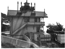
Location San Pablo Bay, California Year first constructed 1873 Deactivated 1917 Construction Wood and Iron Tower shape Square attached to dwelling Height 76 ft Original lens Fourth order Fresnel lens Characteristic Fixed White ARLHS number USA-475 Mare Island Lighthouse was a lighthouse in California, United States, on the north shore of San Pablo Bay at the entrance to Carquinez Strait, California
Contents
History
The lighthouse was razed in the 1930s. This lighthouse was very similar to San Francisco’s East Brother Lighthouse.
The United States Lighthouse Board later realized that a light positioned offshore near the junction of the strait and river would better serve navigation in the area. The Carquinez Strait Light opened in 1909 to replace this light in purpose, but in an offshore location, between the two channels.
A Navy Direction Finding Station was later erected on the site in 1942. It was manned by U.S. Navy radiomen stationed at Naval Radio Station, Mare Island. The station was closed in 1945 after World War II ended and a Navy Radio Beacon was installed.
Gallery
-

1879 Print – U.S. Coast Guard Archive
-

View from pier looking ashore and up at light station – U.S. Coast Guard Archive
-

View from atop mountain down at the light station and pier – U.S. Coast Guard Archive
References
External links
- U.S. Naval High Frequency Direction Finding Sites during World War I and World War II. Part 2
- "Historic Light Station Information and Photography: California". United States Coast Guard Historian's Office. http://www.uscg.mil/history/weblighthouses/LHCA.asp.
- Rudy and Alice Rico. "Mare Island Lighthouse". http://www.rudyalicelighthouse.net/CalLts/MareIs/MareIs.htm. Retrieved 2010-07-25.
 Categories:
- Lighthouses in the San Francisco Bay Area
- History of Solano County, California
- United States lighthouse stubs
- California building and structure stubs
-


Wikimedia Foundation. 2010.