- Point Vicente Light
Infobox Lighthouse
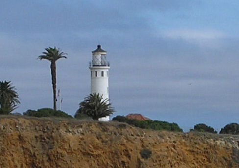
caption = Point Vicente Light
location =Palos Verdes , north ofLos Angeles harbor,California
coordinates = coord|33.7419|N|118.4106|W
yearbuilt = 1926
yearlit = 1926
automated = 1973
yeardeactivated =
foundation =Concrete
construction = ReinforcedConcrete
shape = Cylindrical
height = convert|67|ft|m|abbr=on
currentlens = Cylindrical
lens = Third orderFresnel lens
range =
characteristic = 2 white flashes every 20 s
admiralty = G3886
USCG = 6-0170Point Vicente Lighthouse is a
lighthouse inCalifornia ,United States , inPalos Verdes , north ofLos Angeles Harbor ,California . It is between Point Loma Lighthouse to the south andPoint Conception Light house to the north. The lighthouse is listed on theNational Register of Historic Places .History
Point Vicente Lighthouse was built in 1926 on the
Palos Verdes Peninsula . The light source was dimmed during World War II to avoid aiding the enemy. It was automated in 1971 by theUnited States Coast Guard . The original third orderFresnel lens still revolves in the lantern room.The Point Vicente Lighthouse is an important landmark and beacon light relied by thousands of ships and pleasure craft. It provides a means of fixing their position, and ensuring their safe passage up and down the coast. The Point Vicente Light Station has been guiding sailing vessels to and from the Los Angeles/Long Beach Harbors since March 1926. It was first operated and maintained by the
United States Lighthouse Service for 13 years prior to the service being merged with the U.S. Coast Guard, which was delegated all aid-to-navigation responsibilities in 1939. The lighthouse was manned until 1971 when it was automated by a remote electronic aids-to-navigation monitoring system.The cylindrical tower is convert|67|ft|m tall, and it should be noted that the masonry structure is built on the edge of a convert|130|ft|m|sing=on cliff. This places the center of the lantern convert|185|ft|m above the ocean, and because of this elevation, the 1.1 million candlepower-beam can be seen twenty miles (32 km) away. The most striking feature in the lighthouse is the classical third-order rotating Fresnel Lens located in the lantern. This particular lens was manufactured around 1910 in Paris, France, by Barbier, Bernard and Turenne, the oldest lens making company in the world. This lens is made up of hand-ground prisms held in place by a cast brass frame. The prisms and frame represent an excellent example of the precision achieved by optical scientists and the lens making art in utilizing the known principles and properties of light.This lighthouse also incorporates a pleasant-sounding foghorn to audibly warn ships during times of low visibility which are common to the area.
References
External links
* [http://members.cox.net/jankees/PtVicenteWeathercam.htm Lighthouse Cam]
* [http://www.cr.nps.gov/Maritime/light/vicente.htm Inventory of Historic Light Stations - California Lighthouses - Point Vicente Light]
* [http://www.uscg.mil/hq/g-cp/history/WEBLIGHTHOUSES/LHCA.html USCG site]
* [http://www.uscg.mil/hq/g-cp/history/WEBLIGHTHOUSES/pointvicente.jpgHistorical photo of Pt. Vicente Lighthouse - USCG]
Wikimedia Foundation. 2010.