- Montgomery County, Indiana
-
Montgomery County, Indiana 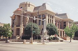 County Courthouse in Crawfordsville
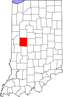
Location in the state of Indiana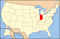
Indiana's location in the U.S.Founded 1823 Seat Crawfordsville Largest city Crawfordsville Area
- Total
- Land
- Water
505.44 sq mi (1,309 km²)
504.61 sq mi (1,307 km²)
0.83 sq mi (2 km²), 0.16%Population
- (2010)
- Density
38,124
76/sq mi (29.18/km²)Congressional district 4th Website www.crawfordsville.org Footnotes: Indiana county number 54
Montgomery County is a county located in the U.S. state of Indiana. As of 2010, the population was 38,124.[1] The county seat is Crawfordsville[2]
Contents
History
Early history and settlement
The earliest known inhabitants of the area that would become Montgomery County were the Mound Builders, Native American peoples who built large earthen mounds, two of which were constructed in southeastern Franklin Township. Subsequent Native American tribes occupied the area until as late as 1832.[3]
The first white settler in the area that would become Montgomery County was William Offield, earlier of Tennessee, who arrived in 1821 with his wife Jennie (née Laughlin) and one child and settled near the confluence of Offield Creek and Sugar Creek, about five miles (8 km) southwest of Crawfordsville. The first land in the county to be purchased from the government was a tract in Scott Township sold to John Loop on July 23, 1822; many more tracts were entered in subsequent months, most in Union Township. The area's settlers mostly came from Kentucky and Ohio, with others arriving from Tennessee, Virginia and the Carolinas.[4]
Montgomery County was established by an act of the Indiana state legislature passed on December 21, 1822, which defined the county's boundaries and provided for the organization of its government. The county was named in honor of Richard Montgomery, an American Revolutionary War general killed on December 31, 1775, while attempting to capture Quebec City in the Battle of Quebec. The first county election was held on March 1, 1823, with 61 voters participating to elect the first three county commissioners — William Offield, James Blevins and John McCollough — who then ordered that the first jail and courthouse be built.[5]
Beginning on December 24, 1824, a large land sale was held for several days at the United States Land Office on North Water Street in Crawfordsville during which a large number of the area's tracts were sold at auction. The money raised from the sale, mostly in the form of gold and silver, was packed into kegs, hauled by wagon to Louisville, carried by boat up the Ohio River, and eventually to Washington, D.C. Settlement increased substantially during the subsequent year.[4]
Courthouses
Montgomery County's first courthouse was ordered on June 28, 1823, to be made "of good hewed logs... to be twenty-six feet long; two stories high, lower story nine feet from floor to joist; upper to be seven feet to roof". Eliakam Ashton won the contract to construct the building and completed it on a lot along Main Street on August 9, 1824, at a cost of $295. In 1825 a contract was issued to Henry Ristine to cut trees and pick up chips from under the courthouse so that "hogs would not find a comfortable place in which to make their beds".
A second, more substantial structure was ordered in 1831, the contract for its construction being awarded to John Hughes for $3,420. The result, completed in 1833, was a two-story, 40x40 foot brick building surmounted by a cupola, later supplemented by separate one-story buildings erected to the north and east as wings of the main structure. The building stood on the current public square for over forty years until being torn down in 1875.[6]
The third and current Montgomery County courthouse was the first courthouse designed by George W. Bunting of Indianapolis; it is one of six of his Indiana courthouses still standing. Bunting had served as a colonel in the Confederacy during the Civil War before establishing himself in Indianapolis; General Lew Wallace, who was on the Union side during the War and was a resident of Montgomery County, spoke at the dedication of the cornerstone in 1875. The building was constructed by McCormack and Sweeney of Columbus at a cost of $150,000, and was completed in 1876.[7]
The cornerstone contains an embedded copper box of memorable items, including the key to the old courthouse and a Henry VIII coin.[8]
Climate and weather
Crawfordsville, Indiana Climate chart (explanation) J F M A M J J A S O N D 2.13314239193.250273.761384.172484.382583.88562483593.478512.865393.851312.63820Average max. and min. temperatures in °F Precipitation totals in inches Source: The Weather Channel[9] Metric conversion J F M A M J J A S O N D 531-10514-78010-39416310422910928149629171022815872611711849611-1673-7Average max. and min. temperatures in °C Precipitation totals in mm In recent years, average temperatures in Crawfordsville have ranged from a low of 14 °F (−10 °C) in January to a high of 85 °F (29 °C) in July, although a record low of −31 °F (−35 °C) was recorded in January 1994 and a record high of 102 °F (39 °C) was recorded in June 1988. Average monthly precipitation ranged from 2.02 inches (51 mm) in February to 4.28 inches (109 mm) in June.[9]
Government
See also: Government of IndianaThe county government is a constitutional body, and is granted specific powers by the Constitution of Indiana, and by the Indiana Code.
County Council: The county council is the legislative branch of the county government and controls all the spending and revenue collection in the county. Representatives are elected from county districts. The council members serve four year terms. They are responsible for setting salaries, the annual budget, and special spending. The council also has limited authority to impose local taxes, in the form of an income and property tax that is subject to state level approval, excise taxes, and service taxes.[10][11]
Board of Commissioners: The executive body of the county is made of a board of commissioners. The commissioners are elected county-wide, in staggered terms, and each serves a four-year term. One of the commissioners, typically the most senior, serves as president. The commissioners are charged with executing the acts legislated by the council, collecting revenue, and managing the day-to-day functions of the county government.[10][11]
Court: The county maintains a small claims court that can handle some civil cases. The judge on the court is elected to a term of four years and must be a member of the Indiana Bar Association. The judge is assisted by a constable who is also elected to a four-year term. In some cases, court decisions can be appealed to the state level circuit court.[11]
County Officials: The county has several other elected offices, including sheriff, coroner, auditor, treasurer, recorder, surveyor, and circuit court clerk. Each of these elected officers serves a term of four years and oversees a different part of county government. Members elected to county government positions are required to declare party affiliations and to be residents of the county.[11]
Libraries
Montgomery County is home to several Carnegie libraries. These libraries were built in the early 1900s by way of grants from Andrew Carnegie. All but one, the Crawfordsville District Public Library, is still in use today. The Crawfordsville Library was moved to a new location on South Washington Street in 2005 after the old building became too small for the growing collection. The old library building is now the home of the Carnegie Museum of Montgomery County, a museum dedicated to the history of Montgomery County. The other Carnegie libraries include: Waveland-Brown Township Public Library, Darlington-Franklin Township Public Library, and Linden-Madison Township Public Library.
Geography
According to the 2010 census, the county has a total area of 505.44 square miles (1,309.1 km2), of which 504.61 square miles (1,306.9 km2) (or 99.84%) is land and 0.83 square miles (2.1 km2) (or 0.16%) is water.[12]
Schools
Adjacent counties
- Tippecanoe County (north)
- Clinton County (northeast)
- Boone County (east)
- Hendricks County (southeast)
- Putnam County (south)
- Parke County (southwest)
- Fountain County (west)
Cities and towns
Unincorporated towns and areas
Extinct towns
- Beckville
- Binford
- Fredericksburg
- North Union
- Troutman
Townships
Major highways
Railroads
Demographics
Historical populations Census Pop. %± 1830 7,317 — 1840 14,438 97.3% 1850 18,084 25.3% 1860 20,888 15.5% 1870 23,765 13.8% 1880 27,316 14.9% 1890 28,025 2.6% 1900 29,388 4.9% 1910 29,296 −0.3% 1920 28,490 −2.8% 1930 26,980 −5.3% 1940 27,231 0.9% 1950 29,122 6.9% 1960 32,089 10.2% 1970 33,930 5.7% 1980 35,501 4.6% 1990 34,436 −3.0% 2000 37,629 9.3% 2010 38,124 1.3% Sources: United States Department of Commerce,
Bureau of the Census, Population Division[13]
Census Quickfacts[1]As of the census[14] of 2000, there were 37,629 people, 14,595 households, and 10,245 families residing in the county. The population density was 75 people per square mile (29/km²). There were 15,678 housing units at an average density of 31 per square mile (12/km²). The racial makeup of the county was 96.77% White, 0.77% Black or African American, 0.19% Native American, 0.42% Asian, 0.03% Pacific Islander, 1.10% from other races, and 0.71% from two or more races. 1.62% of the population were Hispanic or Latino of any race. 23.2% were of German, 22.4% American, 12.9% English and 12.7% Irish ancestry according to Census 2000.
There were 14,595 households out of which 33.40% had children under the age of 18 living with them, 57.60% were married couples living together, 8.60% had a female householder with no husband present, and 29.80% were non-families. 25.30% of all households were made up of individuals and 11.00% had someone living alone who was 65 years of age or older. The average household size was 2.50 and the average family size was 2.97.
In the county the population was spread out with 26.00% under the age of 18, 9.00% from 18 to 24, 28.60% from 25 to 44, 22.60% from 45 to 64, and 13.90% who were 65 years of age or older. The median age was 37 years. For every 100 females there were 99.60 males. For every 100 females age 18 and over, there were 97.80 males.
The median income for a household in the county was $41,297, and the median income for a family was $48,779. Males had a median income of $36,612 versus $23,010 for females. The per capita income for the county was $18,938. About 6.10% of families and 8.30% of the population were below the poverty line, including 11.20% of those under age 18 and 7.00% of those age 65 or over.
See also
References
- ^ a b "Montgomery County QuickFacts". United States Census Bureau. http://quickfacts.census.gov/qfd/states/18/18107.html. Retrieved 2011-09-25.
- ^ "Find a County". National Association of Counties. http://www.naco.org/Counties/Pages/FindACounty.aspx. Retrieved 2011-06-07.
- ^ Bowen, A. W. (1913). History of Montgomery County, Indiana. Indianapolis: A. W. Bowen & Company. pp. 38–39.
- ^ a b Bowen, A. W. (1913). "Early Settlement of the County". History of Montgomery County, Indiana. Indianapolis: A. W. Bowen & Company.
- ^ Gronert, Theodore G., Sugar Creek Saga: A History and Development of Montgomery County, Wabash College, 1958. pg 11
- ^ Bowen, A. W. (1913). "Organization and County Government". History of Montgomery County, Indiana. Indianapolis: A. W. Bowen & Company.
- ^ Counts, Will; Jon Dilts (1991). The 92 Magnificent Indiana Courthouses. Bloomington, Indiana: Indiana University Press. pp. 114–115. ISBN 978-0253336385.
- ^ Riggs, Constance Kakavecos (1976). Montgomery County Remembers. Crawfordsville, Ind.: Montgomery County Historical Society. pp. 67–70.
- ^ a b "Monthly Averages for Crawfordsville, Indiana". The Weather Channel. http://www.weather.com/weather/wxclimatology/monthly/graph/USIN0138. Retrieved 2011-01-27.
- ^ a b Indiana Code. "Title 36, Article 2, Section 3". IN.gov. http://www.in.gov/legislative/ic/code/title36/ar2/ch3.html. Retrieved 2008-09-16.
- ^ a b c d Indiana Code. "Title 2, Article 10, Section 2". IN.gov. http://www.in.gov/legislative/ic/code/title3/ar10/ch2.pdf. Retrieved 2008-09-16.
- ^ "Census 2010 U.S. Gazetteer Files: Counties". United States Census. http://www.census.gov/geo/www/gazetteer/files/Gaz_counties_national.txt. Retrieved 2011-10-10.
- ^ Forstall, Richard L. (editor) (1996). Population of states and counties of the United States: 1790 to 1990 : from the twenty-one decennial censuses. United States Department of Commerce, Bureau of the Census, Population Division. pp. 50–53. ISBN 0-934213-48-8. http://books.google.com/books?id=Z12v1lrkv2IC&lpg=PA50&pg=PA50#v=onepage&q&f=false.
- ^ "American FactFinder". United States Census Bureau. http://factfinder.census.gov. Retrieved 2008-01-31.
External links

Tippecanoe County Clinton County Fountain County 
Boone County  Montgomery County, Indiana

Parke County Putnam County Hendricks County Municipalities and communities of Montgomery County, Indiana City 
Towns Alamo | Darlington | Ladoga | Linden | New Market | New Richmond | New Ross | Waveland | Waynetown | Wingate
Townships Unincorporated
communitiesBalhinch | Beckville | Bowers | Browns Valley | Cherry Grove | Darlington Woods | Deer's Mill | Elmdale | Fiskville | Garfield | Hibernia | Kirkpatrick | Lake Holiday | Lapland | Linnsburg | Log Cabin Crossroads | Mace | Manchester | North Union | Parkersburg | Shannondale | Smartsburg | Sycamore Ford | Taylor Corner | Wesley | Whitesville | Yountsville
Categories:- Indiana counties
- Montgomery County, Indiana
- 1823 establishments in the United States
- Populated places established in 1823


Wikimedia Foundation. 2010.