- M-21 (Michigan highway)
-
This article is about the state highway in Michigan; for other uses, see M21 (disambiguation)
M-21
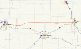
M-21 is highlighted in redRoute information Maintained by MDOT Length: 99.322 mi[2] (159.843 km) Existed: c. July 1, 1919[1] – present Major junctions West end: 
 M-37 / M-44 in Grand Rapids
 M-66 in Ionia
 US 127 near St. Johns
 M-52 in Owosso
 M-13 near Lennon
 I-75 near Flint
East end:  I-475 in Flint
Location Counties: Kent, Ionia, Clinton, Shiawassee, Genesee Highway system Michigan State Trunkline Highway System
Interstate • US • State←  M-20
M-20M-21A  →
→M-21 is an east–west state trunkline highway in the US state of Michigan connecting the cities of Grand Rapids and Flint. The highway passes through rural farming country and several small towns along its course through the Lower Peninsula. Following the course of a handful of rivers, M-21 also connects some of the state's freeways like Interstate 96 (I-96), US Highway 127 (US 127) and I-75. The highway is used by between 1,700 and 36,000 vehicles daily.
M-21 was designated along the highway by July 1, 1919 between Ionia and Goodells near Port Huron. Changes made in the 1920s extended it on the west end to Holland and on the east end to Port Huron. M-21 was truncated at both of its current termini as two Interstate freeways were completed. I-196 functionally replaced M-21 between Holland and Grand Rapids with a portion retained under state maintenance as Old M-21, now M-121. I-69 replaced M-21 from Flint to Port Huron. A section of M-21 through Flint became M-56. That designation was decommissioned in the 1980s when M-21 was returned to its former routing in Flint.
Contents
Route description
M-21 starts on Fulton Street at a junction with M-37/M-44 (East Beltline Avenue) on the east side of greater Grand Rapids. Fulton passes through residential areas on this side of town, and crosses over I-96 Continuing east, the highway passes the headquarters of Amway and crosses the Grand River near its confluence with the Thornapple River in Ada. M-21 runs long the north back of the Grand, turning southeasterly and east to Lowell. The roadway passes through downtown and over the Flat River near its confluence with the Grand. M-21 runs east of town through the southern end of the Lowell State Gaming Area and crosses into Ionia County.[3][4]
The road follows Bluewater Highway along the river, passing to the north of Saranac. It turns northeasterly through lightly forested farmland passing Berth Brock Park as it approaches the city of Ionia. In town, M-66 runs concurrently along M-21 for a few blocks in the central business district. Bluewater Highway leaves town and continues along the Grand River to Muir, and the trunkline crosses the Maple River on east side of town. M-21 follows the course of the Maple briefly before turning east through farms along the Stony Creek to Pewamo. The highway bypasses the village to the south and crosses into Clinton County near the eastern edge of town. Western Clinton County's landscape is dominated by farms, interrupted by the community of Fowler. The highway enters the county seat, St. Johns on State Street, passing through a residential section of town. In the middle of downtown, M-21 intersects 2nd Street, which carries Business US Highway 127 (BUS US 127). East of downtown, M-21 passes back into agricultural land and under the US 127 freeway. The landscape is once again dominated by these farms through the western side of the county.[3][4]
M-21 passes into the community of Ovid and over the county line into Shiawassee County. Continuing east through the county, the highway enters Owosso. The trunkline follows Main Street into downtown and crossess the Shiawassee River between junctions with M-52 and M-71. M-21 runs roughly parallel to the river out into the country side. The remainder of the county is the same, dominated by farmland along a straight stretch of flat highway. North of Lennon, M-21 meets M-13 (Michigan highway) at an intersection on the Shiawassee–Genesee county line. The landscape starts to transition to residential sudvisions as the roadway approaches the Flint area.
In Flint Charter Township, M-21 follows Corunna Road and meets I-75/US 23 at exit 118.[3][4] The road crosses a branch line of the Canadian National Railway east of the interchange.[5] Corunna Road angles to the northeast near Bradley Avenue and terminates at Court Street. The trunkline turns east and follows Court over a tributary of the Flint River near Aldrich Park. Northeast of the stream, M-21 splits along a one-way pairing of Court and 5th streets. Eastbound traffic follows 5th Street past the city and county buildings in the area. The highway passes over I-475 and terminates at the east frontage road. Traffic connecting between M-21 and I-475 must use the frontage roads to make the connection.[3][4]
All of M-21, except for some segments just outside of Grand Rapids and Flint, along with the highway split into two one-way streets inside Flint, is undivided surface road; none of M-21 is freeway.[3] The section between I-75/US 23 and Saginaw Street in Flint is part of the National Highway System,[6] a network of roadways important to the nation's economy, defense, and mobility.[7] M-21, like all state highways, is maintained by the Michigan Department of Transportation (MDOT). As part of these responsibilities, the department tracks traffic volumes along its highways. They use a metric called average annual daily traffic (AADT), which is a calculation of the average traffic along a segment of roadway for any average day of the year. Traffic volumes in 2009 vary from 22,756 vehicles in the Forest Hills neighborhood east of Grand Rapids to 1,719 vehicles in Pewamo daily. MDOT reported that the peak AADT was 36,053 vehicles daily near the I-75 interchange in the Flint area.[8]
History
Before the Interstate era, M-21 extended across the entire Lower Peninsula, from the junction with US 31 in Holland near Lake Michigan east to the St. Clair River at Port Huron, and crossed into Canada where the Blue Water Bridge is currently located.[9]
M-21 was designated by July 1, 1919 on a routing from Ionia to Goodells. Along the way, it ran through Lyons and Pewamo, joining its current routing to Ovid. M-21 continued through Corunna to Lennon and Flint. There it joined its last routing between Flint and the Port Huron area.[1] The highway was extended to Port Huron by 1924,[10] and the west end was extended to Grand Rapids in 1925 along M-16 (later US 16). The previous routing through Owosso and Lennon was redesignated as M-71 at this time when M-21 was shifted along the current routing between the two communities.[11] The 1926 creation of the United States Highway System led to the extension of M-21 along US 16 to Grand Rapids. From there west, M-21 replaced M-51 on Chicago Drive to Holland.[12] The highway was moved to a new routing between Flint and Lapeer in 1929; the old route was renumbered M-21A.[13][14] All in-city portions of M-21 were transferred to state control in 1931 with the passage of the Dykstra Act of 1931 (PA 131 of 1931).[15]
A Bypass M-21 (BYP M-21) designation was created in the Grand Rapids area in 1945. This designation ran from the corner of 28th Street and Chicago Drive along BYP US 16 and BYP US 131 on 28th Street. At East Beltline Avenue, BYP US 131/BYP M-21 turned north back to M-21.[16] M-21A in Flint was turned over to local control in 1948, decommissioning the number.[17][18] The BYP M-21 routing was replaced by M-21 in 1953. The former routing in Grand Rapids became BUS M-21 instead.[19][20]
A bypass of Zeeland opened in 1958, rerouting M-21 around the town.[21] The I-196 freeway opened through Grand Rapids in 1964, and M-21 was routed along the freeway between Chicago Drive in Grandville and downtown, using I-96 to complete the connection to its previous routing on Fulton Street.[22][23]
The first freeway segment of M-21 on the east end was built from Wadhams to Port Huron.[24][25] A freeway segment between Flint and Lapeer opened in 1971. M-21 was routed down M-13 to the new freeway where it joined the M-78 designation from M-13 east. The section of M-21 formerly between M-13 and BUS M-54 was redesignated M-56.[26][27] The M-78 designation was replaced by I-69 in 1973 after I-69 was extended north from Charlotte.[28][29] The 1974 completion of I-196 meant the truncation of M-21 to end in Grand Rapids. At the time, M-21 was extended along Fulton Street to the East Beltline, and the business loop was truncated into a spur route redesignated BS I-196.[30] The remaining segment of freeway connecting Flint with Port Huron opened in 1984 as I-69, and M-21 was shortened to Flint. M-56 was replaced by M-21 at this time as well. The former M-21 in Port Huron became BL I-69, and the remainder was turned back to local control.[31][32]
Michigan legislators have proposed naming the section of highway in Genesee County after University of Alabama tailback Mark Ingram. The state senate approved the measure on November 4, 2010, and the bill moved to the state house for approval.[33] The bill failed to pass the state house during the session.[34]
Major intersections
County Location Mile[2] Destinations Notes Kent Grand Rapids Township 0.000 M-37 / M-44 (East Beltline Avenue)0.610–
0.639 I-96 – Muskegon, Lansing
Exit 39 on I-96; access to M-21 from eastbound I-96 and from M-21 to westbound I-96 only Ionia Ionia 27.867 M-66 north (State Street) – Lake CityWestern end of M-66 concurrency 28.045 M-66 south (Dexter Street) – Battle CreekEastern end of M-66 concurrency Clinton St. Johns 55.249 


BUS US 127 (2nd Street)Bingham Township 56.871–
57.038 US 127 – Clare, LansingExit 96 on US 127 Shiawassee Owosso 74.240 M-52 – Saginaw, Webberville74.552  M-71 east – Durand
Northern terminus of M-71 Shiawassee–
GeneseeVenice Township –
Clayton Township86.817 M-13 – SaginawGenesee Flint Township 95.895–
95.908 I-75 / US 23 – Saginaw, Detroit
Exit 118 on I-75/US 23 Flint 99.322 To I-475 (UAW Freeway)No direct access between M-21 and I-475; traffic must use frontage roads to connect between the two highways 1.000 mi = 1.609 km; 1.000 km = 0.621 mi
Concurrency terminus • Closed/Former • Incomplete access • UnopenedSee also
References
- ^ a b Michigan State Highway Department (July 1, 1919). State of Michigan: Lower Peninsula (Map). Cartography by MSHD.
- ^ a b "MDOT Physical Reference Finder Application". Michigan Department of Transportation. 2009. http://www.mcgi.state.mi.us/prfinder/. Retrieved February 12, 2011.
- ^ a b c d e Michigan Department of Transportation (2010). Official Department of Transportation Map (Map). 1 in:15 mi/1 cm:9 km. Section L9–K12.
- ^ a b c d Google, Inc. Google Maps – Overview Map of M-21 (Map). Cartography by Google, Inc. http://maps.google.com/maps?f=d&source=s_d&saddr=M-21+E%2FFulton+St+E&daddr=43.00171,-84.68462+to:43.00072,-83.89058+to:E+5th+St&hl=en&geocode=FQKPjwIdVgDm-g%3BFW4nkAIdtNDz-imx5-fiYokiiDElz5i8fbSnBQ%3BFZAjkAIdbO7_-ilbfprNcHUjiDEaknqWKlYa5g%3BFWBYkAIdnB8D-w&mra=ls&via=1,2&sll=43.010798,-83.683977&sspn=0.029341,0.029097&ie=UTF8&t=h&z=8. Retrieved February 21, 2011.
- ^ Michigan Department of Transportation (April 2009) (PDF). Michigan's Railroad System (Map). http://www.michigan.gov/documents/MDOT_Official_Rail_130897_7.pdf. Retrieved September 14, 2010.
- ^ Michigan Department of Transportation (April 23, 2006) (PDF). National Highway System, Michigan (Map). http://www.michigan.gov/documents/MDOT_NHS_Statewide_150626_7.pdf. Retrieved October 7, 2008.
- ^ "The National Highway System". Federal Highway Administration. August 26, 2010. http://www.fhwa.dot.gov/planning/nhs/. Retrieved January 1, 2011.
- ^ "Traffic Monitoring Information System". Michigan Department of Transportation. 2008. http://mdotnetpublic.state.mi.us/tmispublic/. Retrieved February 21, 2011.
- ^ Michigan State Highway Department (April 15, 1950). Michigan Official Highway Map (Map). Section L8–L14.
- ^ Michigan State Highway Department (May 15, 1924). Official Highway Service Map (Map). Cartography by MSHD.
- ^ Michigan State Highway Department (September 15, 1925). Official Highway Service Map (Map). Cartography by MSHD.
- ^ Michigan State Highway Department (December 1, 1926). Official Highway Service Map (Map). Cartography by MSHD.
- ^ Michigan State Highway Department (May 1, 1929). Official Highway Service Map (Map). Cartography by MSHD.
- ^ Michigan State Highway Department (January 1, 1930). Official Highway Service Map (Map). Cartography by H.M. Gousha.
- ^ Public Act 131 of 1931, Michigan Legislature.
- ^ Michigan State Highway Department (October 1, 1945). Official Highway Map of Michigan (Map). Grand Rapids inset.
- ^ Michigan State Highway Department (July 1, 1948). 1948 Official Highway Map (Map). Section K12–K13.
- ^ Michigan State Highway Department (April 15, 1949). Michigan Official Highway Map (Map). Section K12–K13.
- ^ Michigan State Highway Department (April 15, 1953). 1953 Official Highway Map (Map). Grand Rapids inset.
- ^ Michigan State Highway Department (October 1, 1953). 1953 Official Highway Map (Map). Grand Rapids inset.
- ^ Michigan State Highway Department (1958). Official Highway Map (Map). Section L8. (Includes all changes through July 1, 1958)
- ^ Michigan State Highway Department (1964). Official Highway Map (Map). Grand Rapids inset.
- ^ Michigan State Highway Department (1965). Official Highway Map (Map). Grand Rapids inset.
- ^ Michigan Department of State Highways (1966). Official Highway Map (Map). Port Huron inset.
- ^ Michigan Department of State Highways (1967). Official Highway Map (Map). Port Huron inset.
- ^ Michigan Department of State Highways (1971). Official Highway Map (Map). 1 in:14.5 mi. Section K12.
- ^ Michigan Department of State Highways (1972). Official Highway Map (Map). 1 in:14.5 mi. Section K12.
- ^ Michigan Department of State Highways (1973). Official Highway Map (Map). 1 in:14.5 mi. Section L10–K12.
- ^ Michigan Department of State Highways and Transportation (1974). Official Highway Map (Map). 1 in:14.5 mi. Section L10–K12, L8–K9.
- ^ Michigan Department of State Highways and Transportation (1975). Official Transportation Map (Map). 1 in:14.5 mi/1 in:23 km. Section L8–K9.
- ^ Michigan Department of Transportation (1984). Official Transportation Map (Map). 1 in:14.5 mi/1 in:23 km. Section K12–K14.
- ^ Michigan Department of Transportation (1985). Official Transportation Map (Map). 1 in:14.5 mi/1 in:23 km. Section K12–K14.
- ^ "Michigan Highway Might Be Named in Ingram's Honor". Chicago Tribune. November 4, 2010. http://www.chicagotribune.com/news/chi-ap-fbc-ingram-highwayho,0,6641210.story=. Retrieved November 5, 2010.
- ^ "Senate Bill 1269 (2010)". Michigan Legislature. December 1, 2011. http://www.legislature.mi.gov/(S(oqowisbhfushwr45veakbq55))/mileg.aspx?page=getobject&objectname=2010-SB-1269&query=on. Retrieved February 21, 2011.
External links
Categories:- State highways in Michigan
- Central Michigan
- Interstate 69
- Transportation in Grand Rapids, Michigan
- Transportation in Genesee County, Michigan


Wikimedia Foundation. 2010.