- Interstate 196
Infobox road
state=MI
type=I
route=196
alternate_name=Gerald R. Ford Freeway
maint=MDOT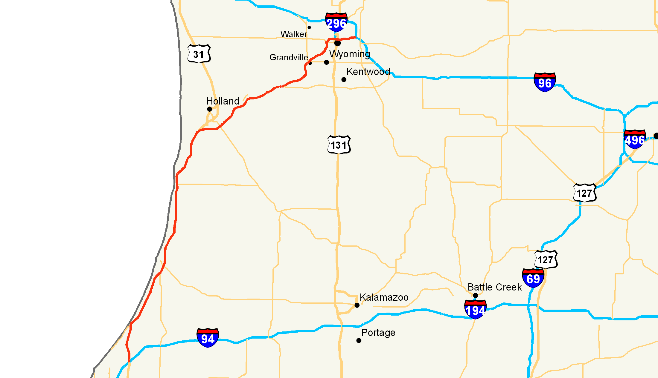
length_mi=80.65
length_round=2
length_ref=cite web|author=|title=Route Log - Auxiliary Routes of the Eisenhower National System Of Interstate and Defense Highways - Table 2|date=2007-03-22 |work=Federal Highway Administration |url=http://www.fhwa.dot.gov/reports/routefinder/table2.htm|accessdate=2007-09-30]
established=1963
direction_a=South
terminus_a=Jct|state=MI|I|94|US|31 near Benton Harbor
junction=Jct|state=MI|US|31 near Holland, MI
Jct|state=MI|I|296|US|131 in Grand Rapids
direction_b=North
terminus_b=Jct|state=MI|I|96|M|37 near Grand Rapids
previous_type=MI
previous_route=195
next_type=MI
next_route=196Interstate 196 (I-196) is a long
freeway spur route in theU.S. state ofMichigan linking Grand Rapids, Holland, South Haven, and Benton Harbor. I-196 is known as the Gerald R. Ford Freeway, or simply the Ford Freeway, in Kent, Ottawa, and Allegan Countiescite web | author= | title= Memorial Highways | date= | work=Michigan Department of Transportation | url= http://mdotwas1.mdot.state.mi.us/public/oga/listall.cfm | accessdate=2007-09-30 ] , after the 38thPresident of the United States , whose political career began in Grand Rapids. This name generally refers only to the section between Holland and Grand Rapids.I-196 changes direction although it is a through route. It is a north-south route from its southern terminus to the junction with US 31 just south of Holland and an east-west route from this point to its eastern terminus. The total length is convert|80.65|mi|km|2|lk=on. Although not the longest Interstate spur route, it may be proportionally the longest "in proportion" to its 'parent', Interstate 96.Or|date=December 2007
At first, Interstate 96 was planned to run from
Detroit to Lansing to Grand Rapids to Benton Harbor, and I-196 was to be a spur route from Grand Rapids to Muskegon. However, I-96 from Detroit to Grand Rapids and I-196 from Grand Rapids to Muskegon was completed a few years before the segment from Grand Rapids to Benton Harbor. Thus it appeared as if I-196 were simply a continuation of I-96. Before the Grand Rapids-Benton Harbor segment was completed, theMichigan Department of Transportation (MDOT) petitioned federal highway officials to switch the interstate designations west of Grand Rapids. Permission for this switch was granted in 1963. Consideration was also made to name the Grand Rapids to Benton Harbor freeway "I-67", but was later withdrawn.Route description
The route begins by mile numbers just north of Benton Harbor in Berrien County. As it travels north it does the usual long haul road of a few bends to keep the drivers awake. Overall it bypasses the few cities that it comes across along the shore of
Lake Michigan . Before it reaches Ottawa County the US 31 route gets removed at the partial interchange south of Holland. From there it travels on a northeast routing through Ottawa County bypassing the cities of Holland, Zeeland, and Hudsonville by a wide margin. The only jog that goes fairly northerly is when it comes close to Chicago Drive on the east side of Zeeland. That is also when Business Loop I-196 begins. As it continues northeast it approaches M-6. After crossing into Kent County it straddles the east side part of the border with Ottawa County and goes north for a few miles until it hits Chicago Drive interchange. From there it travels again with a northeastern path until it crosses theGrand River after being on its side from Chicago Drive. At this point it heads due north to the Lake Michigan Avenue/M-45 interchange. After a short northeast adjustment of the route it travels due east through downtown Grand Rapids and the Medical Corridor to its terminus with the partial interchange with Interstate 96.Highway Construction
Heading Northbound on I-196 from I-94 to South Haven, I-196 is an asphalt highway, which is in fair condition. From Exit 18 to the US 31 Northbound split at Holland, the highway is built in concrete. The highway has been rebuilt in new concrete pavement from M-140 to 71st street North of South Haven. The rest of the concrete pavement from 71st street to the US 31 split is the original 1960's concrete and is in sub-par to fair condition. From Holland to Grand Rapids, I-196 once again becomes an asphalt highway until Lake Michigan Drive in Grand Rapids. At Lake Michigan Drive, the freeway becomes a concrete highway with original 1960's concrete that has been patched and diamond-grinded several times. Once I-196 has entered Grand Rapids through a series of sharp downhill curves, the highway once again becomes asphalt pavement with concrete pavement bridges that were widened in 2001-2002 up to the US 131 interchange. Various ongoing construction projects from US 131 to the I-96 junction are consisting of bridge replacement, roadway widening, new lighting structures and new pavement. The future widening of I-196 is evident at the railroad overpass just east of College Avenue. It has been widened to 3 lanes, but currently only utilizes 2 lanes. I-196 will be upgraded in the next fews years approaching the I-96 and M-37 interchange. [ [http://maps.live.com/] Website shows the pavement surfaces in these areas ]
Future
MDOT currently has two studies underway to improve traffic flow. The first one is nearly completed and construction is planned for 2007-08. The end result of the study is a new exit planned for immediately before the Grandville/Jenison Chicago Drive exit. The exit is needed to alleviate traffic backups for motorists connecting via Chicago Drive to Baldwin Street, which involves crossing heavily-used
CSX railroad tracks. The new exit puts traffic directly onto Baldwin Street, which would allow traffic to avoid crossing the grade level CSX railroad tracks. The start date for this project has been stated as spring of 2008 with a finish date of fall of 2009. According to the latest from MDOT the change will involve reconstructing Baldwin Ave with 5 lanes of traffic and adding a right turn lane to Main St. From Mill St to 196 the current Baldwin Ave will be replaced with a more east-west street. At the Grandville Waste Treatment plant more changes occur. This involves moving the current entrance to one that bridges over Rush Creek. This will allow for the ramps to be built properly and without traffic from the plant causing issues since the current plant entrance is located at the end of the future ramp. Another change will put a cul-de-sac at the end of Old M-21 before Rush Creek. As a result the bridge over the creek will be removed along with the intersection of it with Baldwin St. The only other change is at the intersection of Main St and Baldwin. This involves a new alignment of the intersection with property taken from the Jenison Baptist Temple. On 196 itself two new bridges will be built to take the onramp from Baldwin. Furthermore to accept the new weave merge lane from Chicago Dr to 28th Street two new bridges will be built over Buck Creek.Fact|date=March 2008The other study involves the stretch from US 131 to its connection with I-96. Among the recommendations are: a third lane from the I-96 interchange to US 131; a weave merge lane from Fuller Avenue to Division Avenue; new junctions from eastbound I-96 to westbound I-196, and from eastbound I-196 to westbound I-96; adjustments to exit ramps and local roads; and additional reconfiguration of the M-37/M-44 (East Beltline) interchange area. According to MDOT in the planning part of the website the Federal Government found a "Finding of No Significant Impact" in December 2005. As such the department has decided that a 2010 start date will be used for this project.cite web| url=http://michigan.gov/documents/MDOT_5_Year_Plan_Expandingsystem_143171_7.pdf |title=Expanding the System |format=PDF |accessdate=2008-03-21 |date=December 2005]
Exit list
ee also
There are two business loops and one business spur along I-196:
* BL I-196 in South Haven: From Exit 18 to Exit 20.
* BL I-196 in Holland-Zeeland: From Exit 44 To Exit 55.
* BS I-196 in Wyoming-Grand Rapids: From I-96 Exit 72 To US 131 Exit 83B. Eastbound, this route is on Chicago Drive through Wyoming and Grandville Ave. to Franklin Ave. in Grand Rapids, where it ends at US 131.References
External links
* [http://www.state-ends.com/michigan/i196/ Interstate 196 (Michigan Highway Ends.com)]
* [http://www.michiganhighways.org/listings/MichHwys180-199.html#I-196 Michigan Highways]
* [http://www.kurumi.com/roads/3di/ix96.html 3-digit Interstates from I-96]
Wikimedia Foundation. 2010.