Chipola River

Chipola River
Chipolarivermap.png

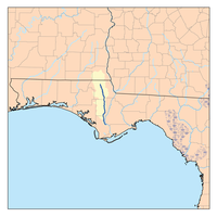
The Chipola River is a tributary of the Apalachicola River in Florida. The 92.5-mile-long (148.9 km)[1] river crosses Jackson, Calhoun and Gulf counties. The river flows into the Dead Lakes State Recreation Area just before reaching the Apalachicola. The Dead Lakes were formed when the Apalachicola deposited sand bars blocking the mouth of the Chipola. The Chipola now flows for several miles south from the Dead Lakes parallel to the Apalachicola before finally joining it.

References

  1. ^ U.S. Geological Survey. National Hydrography Dataset high-resolution flowline data. The National Map, accessed April 15, 2011
  • Marth, Del and Marty Marth, eds. The Rivers of Florida. Sarasota, Florida: Pineapple Press, Inc. ISBN 0-910923-70-1. P. 95.

Coordinates: 30°48′44″N 85°13′56″W / 30.8123025°N 85.2322681°W / 30.8123025; -85.2322681


Wikimedia Foundation. 2010.

Игры ⚽ Поможем написать реферат

Look at other dictionaries:

  • Chipola College — Established 1947 Type Public College President Dr. Gene Prough Students 2,274 Location Marianna, Florida …   Wikipedia

  • Chipola Formation — Stratigraphic range: Late Oligocene Early Miocene Type Geological formation Unit of Alum Bluff Group Lithology Primary Dolostone, phosphate …   Wikipedia

  • Chipola slabshell — Conservation status Endangered (IUCN 2.3) Scientific classification Kingdom …   Wikipedia

  • Apalachicola River — Einzugsgebiet des Apalachicola Rivers DatenVorlage:Infobox Fluss/GKZ fehlt Lage …   Deutsch Wikipedia

  • Apalachicola River — Infobox River river name = Apalachicola River caption = Map of the Apalachicola River watershed showing the two main tributaries, the Chattahoochee River and the Flint River. origin = Confluence of Chattahoochee and Flint Rivers at Chattahoochee …   Wikipedia

  • Ochlockonee River — Coordinates: 29°58′36″N 84°26′15″W / 29.97667°N 84.4375°W / 29.97667; 84.4375 …   Wikipedia

  • Chattahoochee River — Coordinates: 30°42′32″N 84°51′50″W / 30.70889°N 84.86389°W / 30.70889; 84.86389 …   Wikipedia

  • Miami River (Florida) — Miami River The mouth of the Miami River at Brickell Key (February 2010). Origin The Everglades Mouth Brick …   Wikipedia

  • Ocklawaha River — Looking north from the Starkes Ferry bridge on SR 42 …   Wikipedia

  • Manatee River — Map of Manatee river in central Florida Origin northeast Manatee County, Florida Mouth Tampa Bay …   Wikipedia

Share the article and excerpts

Direct link
Do a right-click on the link above
and select “Copy Link”