- List of counties in Mississippi
-
There are 82 counties in the U.S. state of Mississippi. Mississippi is tied with Arkansas for the most counties with two county seats,[citation needed] at ten.[citation needed]
Mississippi's postal abbreviation is MS and its FIPS state code is 28.
List
County FIPS code
[1]County seat
[2]Established
[3]Origin Etymology Population
[2]Area
[3]Map Adams County 001 Natchez 1799 One of two original counties John Adams, second U.S. President 32,297 460 sq mi
(1,191 km2)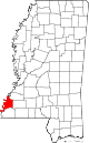
Alcorn County 003 Corinth 1870 Formed from Tippiah and Tishomingo Counties James L. Alcorn, Reconstruction-era U.S. Senator from Mississippi 37,057 400 sq mi
(1,036 km2)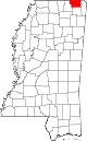
Amite County 005 Liberty 1809 Formed from Wilkinson County Amite River 13,131 730 sq mi
(1,891 km2)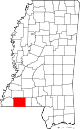
Attala County 007 Kosciusko 1833 Formed from Madison County A fictional Native American heroine from an early 19th-century novel by François-René de Chateaubriand. 19,564 735 sq mi
(1,904 km2)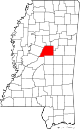
Benton County 009 Ashland 1870 Formed from Marshall and Tippah Counties Thomas Hart Benton, U.S. Senator from Missouri and prominent westward expansion advocate 8,729 407 sq mi
(1,054 km2)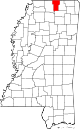
Bolivar County 011 Cleveland and Rosedale 1836 Formed from Tallahatchie and Washington Counties Simon Bolivar, South American democratic revolutionary 34,145 876 sq mi
(2,269 km2)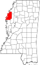
Calhoun County 013 Pittsboro 1852 Formed from Chickasaw, Lafayette and Yalobusha Counties John C. Calhoun, U.S. Senator from South Carolina and prominent supporter of states' rights 14,962 587 sq mi
(1,520 km2)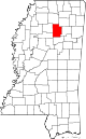
Carroll County 015 Carrollton 1833 Formed from Lowndes, Monroe, Washington and Yazoo Counties Charles Carroll, last surviving signer of the Declaration of Independence 10,597 628 sq mi
(1,627 km2)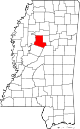
Chickasaw County 017 Houston 1836 Formed from Monroe County and Un-Organized Chickasaw Native Americans 17,392 502 sq mi
(1,300 km2)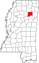
Choctaw County 019 Ackerman 1833 Formed from Lowndes, Madison, Monroe and Yazoo Counties Choctaw Native Americans 8,547 419 sq mi
(1,085 km2)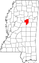
Claiborne County 021 Port Gibson 1802 Formed from Jefferson (Pickering) County William C. C. Claiborne, first Governor of Louisiana 9,604 487 sq mi
(1,261 km2)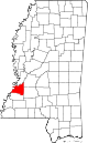
Clarke County 023 Quitman 1833 Formed from Wayne County Joshua G. Clark, the first elected judge following admittance to the Union 16,732 691 sq mi
(1,790 km2)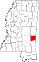
Clay County 025 West Point 1871 Formed from Chickasaw, Lowndes, Monroe and Oktibbeha Counties (formerly (Colfax County) Henry Clay, U.S. Senator from Kentucky and giant of Nineteenth Century politics 20,634 409 sq mi
(1,059 km2)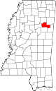
Coahoma County 027 Clarksdale 1836 Formed from Un-Organized derives from Native American word meaning "red panther" 26,151 554 sq mi
(1,435 km2)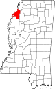
Copiah County 029 Hazlehurst 1823 Formed from Franklin and Hinds Counties derives from Native American word meaning "calling panther" 29,449 777 sq mi
(2,012 km2)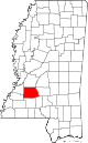
Covington County 031 Collins 1819 Formed from Lawrence and Wayne Counties Leonard Covington, American Revolutionary War general 19,568 414 sq mi
(1,072 km2)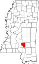
DeSoto County 033 Hernando 1836 Formed from Monroe and Washington Counties Hernando de Soto, Spanish explorer of the Americas 161,252 478 sq mi
(1,238 km2)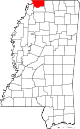
Forrest County 035 Hattiesburg 1906 Formed from Perry County Nathan B. Forrest, Confederate general during the American Civil War 74,934 467 sq mi
(1,210 km2)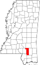
Franklin County 037 Meadville 1809 Formed from Adams County Benjamin Franklin, writer, orator, publisher, and U.S. founding father 8,118 565 sq mi
(1,463 km2)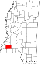
George County 039 Lucedale 1910 Formed from Greene and Jackson Counties James Z. George, U.S. Senator from Mississippi 22,578 478 sq mi
(1,238 km2)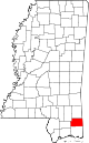
Greene County 041 Leakesville 1811 Formed from Wayne County Nathanael Greene, Revolutionary War general 14,400 713 sq mi
(1,847 km2)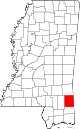
Grenada County 043 Grenada 1870 Formed from Carroll, Choctaw, Tallahatchie and Yalobusha Counties Spanish province of Grenada 21,906 422 sq mi
(1,093 km2)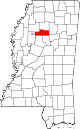
Hancock County 045 Bay Saint Louis 1812 Formed from Un-Organized John Hancock, first signer of the Declaration of Independence 43,929 477 sq mi
(1,235 km2)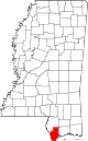
Harrison County 047 Gulfport and Biloxi 1841 Formed from Hancock County William Henry Harrison, ninth U.S. President 187,105 581 sq mi
(1,505 km2)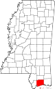
Hinds County 049 Jackson 1821 Formed from Un-Organized (Choctaw Cession of 1820) Thomas Hinds, War of 1812 general 245,285 869 sq mi
(2,251 km2)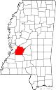
Holmes County 051 Lexington 1833 Formed from Yazoo County David Holmes, first Governor of Mississippi 19,198 756 sq mi
(1,958 km2)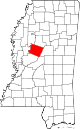
Humphreys County 053 Belzoni 1918 Formed from Holmes, Sunflower, Washington and Yazoo Counties Benjamin G. Humphreys, Reconstruction-era Governor of Mississippi 9,375 418 sq mi
(1,083 km2)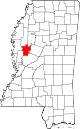
Issaquena County 055 Mayersville 1844 Formed from Washington County Native American word for "Deer River" 1,406 413 sq mi
(1,070 km2)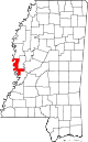
Itawamba County 057 Fulton 1836 Formed from Monroe County Itawamba, Chickasaw chief 23,401 532 sq mi
(1,378 km2)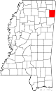
Jackson County 059 Pascagoula 1812 Formed from Un-Organized Andrew Jackson, War of 1812 hero and seventh U.S. President 139,668 727 sq mi
(1,883 km2)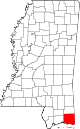
Jasper County 061 Bay Springs 1833 Formed from Jones and Wayne Counties William Jasper, Revolutionary War sergeant 17,062 676 sq mi
(1,751 km2)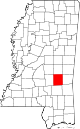
Jefferson County 063 Fayette 1799 One of two original Counties (formerly Pickering) Thomas Jefferson, third U.S. President and principal author of the Declaration of Independence 7,726 519 sq mi
(1,344 km2)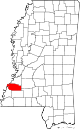
Jefferson Davis County 065 Prentiss 1906 Formed from Covington and Lawrence Counties Jefferson Davis, only president of the Confederate States of America 12,487 408 sq mi
(1,057 km2)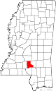
Jones County 067 Laurel 1826 Formed from Covington and Wayne Counties (formerly Davis (1865-1869 (Civil War)) John Paul Jones, Revolutionary War naval captain 67,761 694 sq mi
(1,797 km2)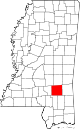
Kemper County 069 De Kalb 1833 Formed from Lowndes, Rankin and Wayne Counties Reuben Kemper, American pioneer and revolutionary in Spanish Florida 10,456 766 sq mi
(1,984 km2)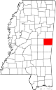
Lafayette County 071 Oxford 1836 Formed from Monroe County Marquis de la Fayette, French-born Revolutionary War general 47,351 631 sq mi
(1,634 km2)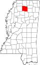
Lamar County 073 Purvis 1904 Formed from Marion and Pearl River Counties Lucius Q. C. Lamar, U.S. Senator from Mississippi and U.S. Secretary of Interior 55,658 497 sq mi
(1,287 km2)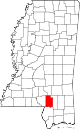
Lauderdale County 075 Meridian 1833 Formed from Rankin and Wayne Counties James Lauderdale, War of 1812 colonel 80,261 704 sq mi
(1,823 km2)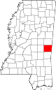
Lawrence County 077 Monticello 1814 Formed from Marion County James Lawrence, War of 1812 naval captain 12,929 431 sq mi
(1,116 km2)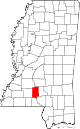
Leake County 079 Carthage 1833 Formed from Madison and Rankin Counties Walter Leake, Governor of Mississippi 23,805 583 sq mi
(1,510 km2)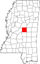
Lee County 081 Tupelo 1866 Formed from Itawamba and Pontotoc Counties Robert E. Lee, commanding Confederate general 82,910 450 sq mi
(1,165 km2)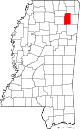
Leflore County 083 Greenwood 1871 Formed from Carroll and Sunflower Counties Greenwood LeFlore, mixed-race advocate of citizenship for Native Americans and U.S. Senator from Mississippi 32,317 592 sq mi
(1,533 km2)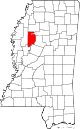
Lincoln County 085 Brookhaven 1870 Formed from Amite, Copiah, Franklin, Lawrence and Pike Counties Abraham Lincoln, sixteenth U.S. President 34,869 586 sq mi
(1,518 km2)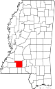
Lowndes County 087 Columbus 1830 Formed from Monroe County and Un-Organized William Jones Lowndes, U.S. Representative from South Carolina 59,779 502 sq mi
(1,300 km2)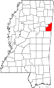
Madison County 089 Canton 1828 Formed from Yazoo County James Madison, fourth U.S. President 95,203 719 sq mi
(1,862 km2)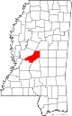
Marion County 091 Columbia 1811 Formed from Amite, Franklin and Wayne Counties Francis Marion, Revolutionary War general 27,088 542 sq mi
(1,404 km2)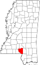
Marshall County 093 Holly Springs 1836 Formed from Monroe County John Marshall, Chief Justice of the United States who shaped the Supreme Court's power 37,144 706 sq mi
(1,829 km2)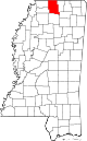
Monroe County 095 Aberdeen 1821 Formed from Un-Organized (Chickasaw Cession of 1816) James Monroe, fifth U.S. President 36,989 764 sq mi
(1,979 km2)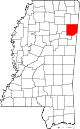
Montgomery County 097 Winona 1871 Formed from Carroll and Choctaw Counties Richard Montgomery, Revolutionary War general 10,925 407 sq mi
(1,054 km2)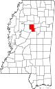
Neshoba County 099 Philadelphia 1833 Formed from Jones, Madison, Rankin and Wayne Counties Native American word for "gray wolf" 29,676 570 sq mi
(1,476 km2)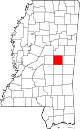
Newton County 101 Decatur 1836 Formed from Neshoba County Isaac Newton, English scientist 21,720 578 sq mi
(1,497 km2)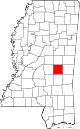
Noxubee County 103 Macon 1833 Formed from Lowndes and Rankin Counties Native American for "stinking water" 11,545 695 sq mi
(1,800 km2)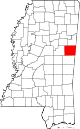
Oktibbeha County 105 Starkville 1833 Formed from Lowndes County Native American word for "bloody water" 47,671 458 sq mi
(1,186 km2)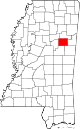
Panola County 107 Batesville 1836 Formed from Monroe and Washington Counties Native American for "cotton" 34,707 684 sq mi
(1,772 km2)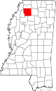
Pearl River County 109 Poplarville 1890 Formed from Hancock and Marion Counties Pearl River 55,834 812 sq mi
(2,103 km2)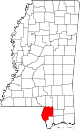
Perry County 111 New Augusta 1820 Formed from Greene County Oliver Hazard Perry, War of 1812 naval captain 12,250 647 sq mi
(1,676 km2)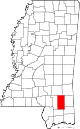
Pike County 113 Magnolia 1815 Formed from Marion County Zebulon Pike, western explorer 40,404 409 sq mi
(1,059 km2)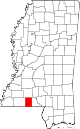
Pontotoc County 115 Pontotoc 1836 Formed from Monroe County Native American for "land of hanging grapes" 29,957 497 sq mi
(1,287 km2)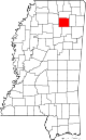
Prentiss County 117 Booneville 1870 Formed from Itawamba and Tishomingo Counties Seargent Smith Prentiss, U.S. Representative from Mississippi 25,276 415 sq mi
(1,075 km2)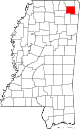
Quitman County 119 Marks 1877 Formed from Coahoma, Panola, Tallahatchie and Tunica Counties John A. Quitman, Governor of Mississippi 8,223 405 sq mi
(1,049 km2)
Rankin County 121 Brandon 1828 Formed from Hinds County Christopher Rankin, U.S. Representative from Mississippi 141,617 775 sq mi
(2,007 km2)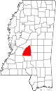
Scott County 123 Forest 1833 Formed from Covington, Jones and Rankin Counties Abram M. Scott, Governor of Mississippi 28,264 609 sq mi
(1,577 km2)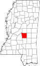
Sharkey County 125 Rolling Fork 1876 Formed from Issaquena, Warren and Washington Counties William L. Sharkey, Mississippi Supreme Court justice 4,916 428 sq mi
(1,109 km2)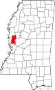
Simpson County 127 Mendenhall 1824 Formed from Copiah County Josiah Simpson, first federal judge appointed in the state 27,503 589 sq mi
(1,526 km2)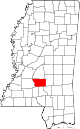
Smith County 129 Raleigh 1833 Formed from Covington, Jones and Rankin Counties David Smith, Revolutionary War major 16,491 636 sq mi
(1,647 km2)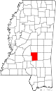
Stone County 131 Wiggins 1916 Formed from Harrison County John M. Stone, Governor of Mississippi 17,786 445 sq mi
(1,153 km2)
Sunflower County 133 Indianola 1844 Formed from Bolivar County Sunflower River 29,450 694 sq mi
(1,797 km2)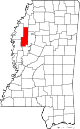
Tallahatchie County 135 Charleston 1833 Formed from Washington and Yazoo Counties Tallahatchie River 15,378 644 sq mi
(1,668 km2)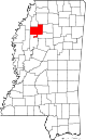
Tate County 137 Senatobia 1873 Formed from DeSoto and Marshall Counties Thomas Simpson Tate, the county's original settler 28,886 404 sq mi
(1,046 km2)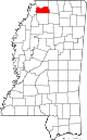
Tippah County 139 Ripley 1836 Formed from Monroe County Native American word for "cut off" 22,232 458 sq mi
(1,186 km2)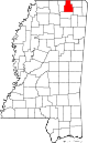
Tishomingo County 141 Iuka 1836 Formed from Monroe County Chief Tishomingo, Chickasaw leader 19,593 424 sq mi
(1,098 km2)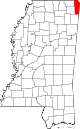
Tunica County 143 Tunica 1836 Formed from Washington County and Un-Organized Tunica Native Americans 10,778 455 sq mi
(1,178 km2)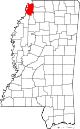
Union County 145 New Albany 1870 Formed from Lee, Pontotoc and Tippah Counties Reunion of Confederacy with the United States 27,134 416 sq mi
(1,077 km2)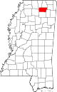
Walthall County 147 Tylertown 1912 Formed from Marion and Pike Counties Edward Walthall, U.S. Senator from Mississippi 15,443 404 sq mi
(1,046 km2)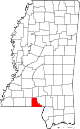
Warren County 149 Vicksburg 1809 Formed from Claiborne County Joseph Warren, Revolutionary War general 48,773 587 sq mi
(1,520 km2)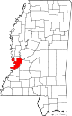
Washington County 151 Greenville 1827 Formed from Warren and Yazoo Counties George Washington, first U.S. President 51,137 724 sq mi
(1,875 km2)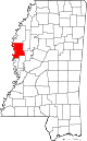
Wayne County 153 Waynesboro 1809 Formed from Washington County (AL) Anthony Wayne, Revolutionary War general 20,747 810 sq mi
(2,098 km2)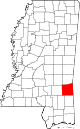
Webster County 155 Walthall 1874 Formed from Chickasaw, Choctaw and Montegomery Counties (formerly Sumner County) Daniel Webster, U.S. Senator from Massachusetts and giant of Nineteenth Century politics 10,253 423 sq mi
(1,096 km2)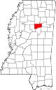
Wilkinson County 157 Woodville 1802 Formed from Adams County James Wilkinson, Revolutionary War general 9,878 677 sq mi
(1,753 km2)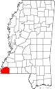
Winston County 159 Louisville 1833 Formed from Lowndes, Rankin, and Wayne Counties Louis Winston, Mississippi Supreme Court justice 19,198 607 sq mi
(1,572 km2)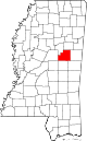
Yalobusha County 161 Water Valley 1833 Formed from Monroe, Washington and Yazoo Counties Native American for "tadpole place" 12,678 467 sq mi
(1,210 km2)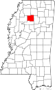
Yazoo County 163 Yazoo City 1823 Formed from Hinds County Yazoo Native Americans 28,065 920 sq mi
(2,383 km2)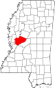
Former counties
- Bainbridge (1823-1824): formed from Covington County and dissolved into Covington.
- Pearl (1872-1878): formed from Hancock and dissolved into both Hancock and Marion.
This list does not include counties now in Alabama.
References
- ^ "EPA County FIPS Code Listing". EPA.gov. http://www.epa.gov/enviro/html/codes/ms.html. Retrieved 2008-02-23.
- ^ a b Bureau of the Census, USA. "GeoHive - USA, Mississippi state population statistics". http://www.geohive.com/cntry/us-ms.aspx. Retrieved 7 April 2011.
- ^ a b National Association of Counties. "NACo - Find a county". http://www.naco.org/Template.cfm?Section=Find_a_County&Template=/cffiles/counties/state.cfm&state.cfm&statecode=MS. Retrieved 2008-04-30.
 State of Mississippi
Topics Regions Metros - Gulfport-Biloxi
- Hattiesburg
- Jackson
- Memphis (TN)
- Pascagoula
Larger cities Smaller cities Counties - Adams
- Alcorn
- Amite
- Attala
- Benton
- Bolivar
- Calhoun
- Carroll
- Chickasaw
- Choctaw
- Claiborne
- Clarke
- Clay
- Coahoma
- Copiah
- Covington
- DeSoto
- Forrest
- Franklin
- George
- Greene
- Grenada
- Hancock
- Harrison
- Hinds
- Holmes
- Humphreys
- Issaquena
- Itawamba
- Jackson
- Jasper
- Jefferson
- Jefferson Davis
- Jones
- Kemper
- Lafayette
- Lamar
- Lauderdale
- Lawrence
- Leake
- Lee
- Leflore
- Lincoln
- Lowndes
- Madison
- Marion
- Marshall
- Monroe
- Montgomery
- Neshoba
- Newton
- Noxubee
- Oktibbeha
- Panola
- Pearl River
- Perry
- Pike
- Pontotoc
- Prentiss
- Quitman
- Rankin
- Scott
- Sharkey
- Simpson
- Smith
- Stone
- Sunflower
- Tallahatchie
- Tate
- Tippah
- Tishomingo
- Tunica
- Union
- Walthall
- Warren
- Washington
- Wayne
- Webster
- Wilkinson
- Winston
- Yalobusha
- Yazoo
Categories:- Lists of U.S. counties by state
- Mississippi counties
- Mississippi-related lists


Wikimedia Foundation. 2010.