- List of counties in Nevada
-
This is a List of counties in Nevada. There are sixteen counties and one independent city in the U.S. state of Nevada. On November 25, 1861, the first Nevada Territorial Legislature established nine counties.[1] Nevada was admitted to the Union on October 31, 1864 with eleven counties.[1] In 1969, Ormsby County and Carson City were consolidated into a single municipal government known as Carson City.[1]
The FIPS county code is the five-digit Federal Information Processing Standard (FIPS) code which uniquely identifies counties and county equivalents in the United States.[2] The three-digit number is unique to each individual county within a state, but to be unique within the entire United States, it must be prefixed by the state code. This means that, for example, while Nye County, Nevada is number 023, Humboldt County, California and Grant County, Oregon also have the number 023. While Humboldt County, Nevada has number 013, Humboldt County, Iowa has number 091. To uniquely identify Nye County, Nevada, you would need to use the state code of 32 plus the county code of 023. Thus, the unique identifier in the entire United States for Humboldt County, Nevada would be 32013, while Nye County, Nevada would be 32023, etc.
Alphabetical list
County FIPS code
[2]County seat
[3]Created
[3]Origin
[4]Etymology
[1][4]Population
[3][5]Area
[3][5]Map Carson City 510 (Independent city) 1969 Founded 1858, consolidated with rump Ormsby county in 1969. Carson River, named in turn for Christopher Houston (Kit) Carson (1809–1868), the frontier scout and soldier. 52,457 144 mi²
(373 km²)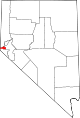
Churchill County 001 Fallon 1861 Original Sylvester Churchill (1783–1862), a general in the Mexican-American War. 23,982 4,929 sq mi
(12,766 km2)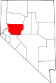
Clark County 003 Las Vegas 1908 Lincoln County William A. Clark (1839–1925), former United States Senator from Montana, and builder of a rail-road line through the area. 1,375,765 7,911 sq mi
(20,489 km2)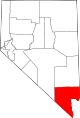
Douglas County 005 Minden 1861 Original Stephen Arnold Douglas (1813–1861), former United States Senator from Illinois. 41,259 710 sq mi
(1,839 km2)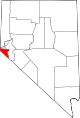
Elko County 007 Elko 1869 Lander County A Shoshoni word meaning white woman. It is said, among the very old Shoshoni, that this is where they first saw a white woman. 45,291 17,182 sq mi
(44,501 km2)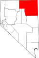
Esmeralda County 009 Goldfield 1861 Original Esmeralda Mining District, named in turn for possibly the character Esmeralda of The Hunchback of Notre Dame. Esmeralda is the Spanish and Portuguese word for emerald. 971 3,589 sq mi
(9,295 km2)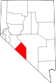
Eureka County 011 Eureka 1873 Lander County Greek expression Eureka, meaning I have found it!, in reference to deposits of silver found in the vicinity. 1,651 4,176 sq mi
(10,816 km2)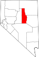
Humboldt County 013 Winnemucca 1861 Original Humboldt River, named in turn for Alexander von Humboldt (1769–1859), a German naturalist and explorer. 16,106 9,648 sq mi
(24,988 km2)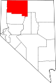
Lander County 015 Battle Mountain 1861 Original Frederick W. Lander (1821–1862), an American Civil War general and developer of the area. 5,794 5,494 sq mi
(14,229 km2)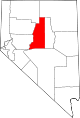
Lincoln County 017 Pioche 1866 Nye County and territory ceded by Arizona. Abraham Lincoln (1809–1865), the sixteenth President of the United States. 4,165 10,635 sq mi
(27,545 km2)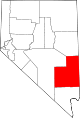
Lyon County 019 Yerington 1861 Original General Nathaniel Lyon (1818–1861), who was killed in action at the Battle of Wilson's Creek. 34,501 1,994 sq mi
(5,164 km2)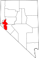
Mineral County 021 Hawthorne 1911 Esmeralda County Mineral deposits in the area. 5,071 3,757 sq mi
(9,731 km2)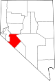
Nye County 023 Tonopah 1864 Esmeralda County James W. Nye (1815–1876), a governor of the Nevada Territory and U.S. senator from Nevada. 32,485 18,147 sq mi
(47,001 km2)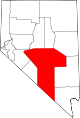
Pershing County 027 Lovelock 1919 Humboldt County John Joseph (Black Jack) Pershing (1860–1948), the World War I general. 6,693 6,009 sq mi
(15,563 km2)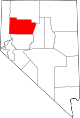
Storey County 029 Virginia City 1861 Original Edward Farris Storey (1829–1860), a captain killed at Pyramid Lake in the 1860 Paiute War. 3,399 264 sq mi
(684 km2)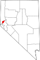
Washoe County 031 Reno 1861 Original The Washo, a small Indian tribe that inhabits the area. 339,486 6,342 sq mi
(16,426 km2)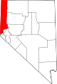
White Pine County 033 Ely 1869 Lander County Heavy growth of pine trees in the area, thought to be white pine. 9,181 8,877 sq mi
(22,991 km2)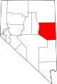
Defunct counties
- Bullfrog County, Nevada, formed in 1987 from part of Nye county. Creation declared unconstitutional and abolished in 1989.[1]
- Lake County, Nevada, one of the original nine counties formed in 1861. Renamed Roop county in 1862. Part became Lassen County, California in 1864. Nevada remainder annexed in 1883 to Washoe county.[1]
- Ormsby County, Nevada, one of the original nine counties formed in 1861. Consolidated in 1969 with Carson City, Nevada, forming the independent city of that name.[1]
References
- ^ a b c d e f g "Political History of Nevada". Nevada State Library and Archives.. http://dmla.clan.lib.nv.us/docs/nsla/archives/political/historical/hist19.htm. Retrieved 2007-08-17.
- ^ a b "EPA County FIPS Code Listing". US Environmental Protection Agency. http://www.epa.gov/enviro/html/codes/nv.html. Retrieved 2007-08-18.
- ^ a b c d "NACo - Find a county". National Association of Counties. Archived from the original on 2007-07-06. http://web.archive.org/web/20070706204434/http://www.naco.org/Template.cfm?Section=Find_a_County&Template=/cffiles/counties/state.cfm&state.cfm&statecode=NV. Retrieved 2007-08-16.
- ^ a b "Counties of Nevada". Nevada-History.org. http://nevada-history.org/county.html. Retrieved 2007-08-18.
- ^ a b "Nevada QuickFacts". U.S. Census Bureau. http://quickfacts.census.gov/qfd/maps/nevada_map.html. Retrieved 2007-08-16. (2000 Census)
 State of Nevada
Carson City (capital) Topics Delegations · Geography · Government · History · People · Transportation · Visitor attractions
Society Crime · Demographics · Economy · Education · Politics
Regions Black Rock Desert · Eagle Valley · Great Basin · Lake Mead · Lake Tahoe · Las Vegas Valley · Mojave Desert · Pahranagat Valley · Sierra Nevada
Metro areas Las Vegas-Paradise · Reno-Sparks · Carson City
Counties Cities and
communitiesAlamo · Amargosa Valley · Austin · Baker · Battle Mountain · Beatty · Boulder City · Caliente · Carlin · Carson City · Elko · Ely · Enterprise · Eureka · Fallon · Fernley · Gardnerville Ranchos · Gerlach · Goldfield · Hawthorne · Henderson · Incline Village · Las Vegas · Laughlin · Lovelock · Mesquite · Minden · North Las Vegas · Pahrump · Paradise · Pioche · Primm · Rachel · Reno · Spanish Springs · Sparks · Spring Creek · Spring Valley · Stateline · Summerlin South · Sun Valley · Sunrise Manor · Tonopah · Virginia City · West Wendover · Winnemucca · Whitney · Winchester · Yerington
Former counties Categories:- Lists of U.S. counties by state
- Nevada counties


Wikimedia Foundation. 2010.