- List of counties in Nebraska
-

The following is a list of the 93 counties in the U.S. state of Nebraska, listed by name, FIPS code and license plate prefix.
Nebraska's postal abbreviation is NE and its FIPS state code is 31.
When many counties were formed, the bills forming the counties did not state the honoree's full name; thus several counties' namesakes are known by only last names. (Brown, Deuel, Dixon, and possibly Harlan to be exact.)
County list
County FIPS code
[1]County seat
[2]Established
[2]Origin Etymology License plate prefix
[3]Population
[2]Area
[2]Map Adams County 001 Hastings 1867 Un-Organized John Adams, Founding Father and the second President of the United States 14 31,151 563 sq mi
(1,458 km2)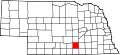
Antelope County 003 Neligh 1871 Un-Organized Pronghorn, often called antelope 26 7,452 857 sq mi
(2,220 km2)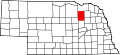
Arthur County 005 Arthur 1887 Un-Organized Chester A. Arthur, twenty-first president of the United States 91 444 715 sq mi
(1,852 km2)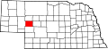
Banner County 007 Harrisburg 1888 Formed from Cheyenne Named for the hope of the early settlers to make the county the "banner county" of the state 85 819 746 sq mi
(1,932 km2)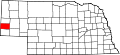
Blaine County 009 Brewster 1885 Unorganized James G. Blaine (1843-1923), U.S. Representative, Speaker of the United States House of Representatives, U.S. Senator from Maine, two-time United States Secretary of State, and Republican candidate in the 1884 presidential election 86 583 711 sq mi
(1,841 km2)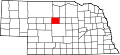
Boone County 011 Albion 1871 Unorganized Daniel Boone, American pioneer and trapper 23 6,259 687 sq mi
(1,779 km2)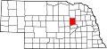
Box Butte County 013 Alliance 1887 Formed from Dawes Named for a large box-shaped butte located approximately six miles north of Alliance, Nebraska, the county seat. 65 12,158 1,075 sq mi
(2,784 km2)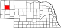
Boyd County 015 Butte 1891 Holt County, and Un-Organized (Indian Territory) James E. Boyd, the eighth governor of Nebraska 63 2,438 540 sq mi
(1,399 km2)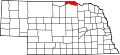
Brown County 017 Ainsworth 1883 Un-Organized The Brown family of early settlers 75 3,525 1,221 sq mi
(3,162 km2)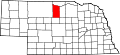
Buffalo County 019 Kearney 1855 Un-Organized Named for the American Bison which once roamed the present county 9 42,259 968 sq mi
(2,507 km2)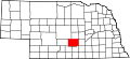
Burt County 021 Tekamah 1854 One of Nine Original Counties Francis Burt, the first territorial governor of Nebraska who died after two days in office. 31 7,791 493 sq mi
(1,277 km2)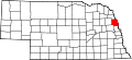
Butler County 023 David City 1856 Formed from Greene William Orlando Butler, U.S. Congressman from Kentucky and Mexican-American War hero 25 8,767 584 sq mi
(1,513 km2)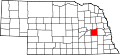
Cass County 025 Plattsmouth 1854 One of Nine Original Counties Lewis Cass, the territorial administrator and U.S. Senator from Michigan 20 24,334 559 sq mi
(1,448 km2)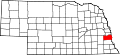
Cedar County 027 Hartington 1857 Formed from Dixon and Pierce Counties Named for the many juniper trees (locally mis-identified as cedars) in the area 13 9,615 740 sq mi
(1,917 km2)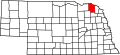
Chase County 029 Imperial 1873 Un-Organized Champion S. Chase, a mayor of Omaha, Nebraska who served as Nebraska's first attorney general 72 4,068 894 sq mi
(2,315 km2)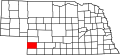
Cherry County 031 Valentine 1883 Un-Organized Samuel A. Cherry, army lieutenant killed in the Indian Wars 66 6,148 5,961 sq mi
(15,439 km2)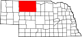
Cheyenne County 033 Sidney 1867 Un-Organized Named for the Cheyenne Native American tribe 39 9,830 1,196 sq mi
(3,098 km2)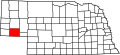
Clay County 035 Clay Center 1855 Formed from Un-Organized Henry Clay, the Senator from Kentucky, U.S. Secretary of State, and presidential candidate 30 7,039 573 sq mi
(1,484 km2)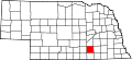
Colfax County 037 Schuyler 1869 Formed from Platte County Schuyler Colfax, Speaker of the U.S. House of Representatives and Vice President of the United States 43 10,441 413 sq mi
(1,070 km2)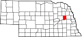
Cuming County 039 West Point 1855 Formed from Burt County Thomas B. Cuming, first Secretary of Nebraska Territory 24 10,203 572 sq mi
(1,481 km2)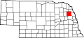
Custer County 041 Broken Bow 1877 Un-Organized George Armstrong Custer, general in the Civil War and Indian Wars 4 11,793 2,576 sq mi
(6,672 km2)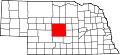
Dakota County 043 Dakota City 1855 Formed from Burt County Named for the Dakota branch of the Sioux Native American tribe 70 20,253 264 sq mi
(684 km2)
Dawes County 045 Chadron 1885 Formed from Sioux County James W. Dawes, the sixth governor of Nebraska 69 9,060 1,396 sq mi
(3,616 km2)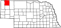
Dawson County 047 Lexington 1860 Un-Organized Jacob Dawson, the first postmaster in present-day Lincoln, Nebraska, the state capital 18 24,365 1,013 sq mi
(2,624 km2)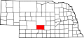
Deuel County 049 Chappell 1888 Formed from Cheyenne County The Deuel family of early settlers 78 2,098 440 sq mi
(1,140 km2)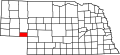
Dixon County 051 Ponca 1856 Formed from Blackbird County, Izard County and Un-Organized The Dixon family of early settlers 35 6,339 476 sq mi
(1,233 km2)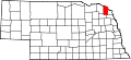
Dodge County 053 Fremont 1854 One of Nine Original Counties Augustus Caesar Dodge, a United States senator from Iowa who was a supporter of the Kansas-Nebraska Act 5 36,160 534 sq mi
(1,383 km2)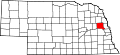
Douglas County 055 Omaha 1854 One of Nine Original Counties Stephen Arnold Douglas, the American statesman, U. S. senator, and presidential candidate 1 463,585 331 sq mi
(857 km2)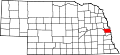
Dundy County 057 Benkelman 1873 Un-Organized Elmer Scipio Dundy, a U.S. Circuit Court judge from Nebraska 76 2,292 920 sq mi
(2,383 km2)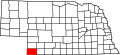
Fillmore County 059 Geneva 1856 Formed from Jackson County and Un-Organized Millard Fillmore, the thirteenth president of the United States 34 6,634 576 sq mi
(1,492 km2)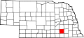
Franklin County 061 Franklin 1867 Formed from Kearney Benjamin Franklin, the Founding Father, printer, scientist, and diplomat 50 3,574 576 sq mi
(1,492 km2)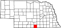
Frontier County 063 Stockville 1872 Un-organized Named for the fact that it was located in what was referred to at that time as part of the Nebraska frontier 60 3,099 975 sq mi
(2,525 km2)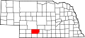
Furnas County 065 Beaver City 1873 Un-Organized Robert Wilkinson Furnas, the third governor of Nebraska 38 5,324 718 sq mi
(1,860 km2)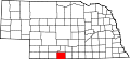
Gage County 067 Beatrice 1855 Un-Organized William D. Gage, a Methodist minister who served as chaplain of the state legislature at the time the county was established 3 22,993 855 sq mi
(2,214 km2)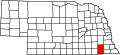
Garden County 069 Oshkosh 1910 Formed from Deuel County Named for the hopes of two real estate agents and citizens of the county seat, Oshkosh, Nebraska, that the county would be the "garden spot of the west" 77 2,292 1,705 sq mi
(4,416 km2)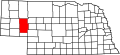
Garfield County 071 Burwell 1884 Formed from Wheeler County James Abram Garfield, the twentieth president of the United States 83 1,902 570 sq mi
(1,476 km2)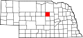
Gosper County 073 Elwood 1873 Un-Organized John J. Gosper, the secretary of state for Nebraska at the time of the county's formation 73 2,143 458 sq mi
(1,186 km2)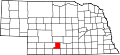
Grant County 075 Hyannis 1887 Un-Organized Ulysses Simpson Grant, the eighteenth president of the United States and American Civil War general 92 747 776 sq mi
(2,010 km2)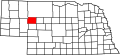
Greeley County 077 Greeley 1871 Un-Organized Horace Greeley, the pioneering American journalist 62 2,714 570 sq mi
(1,476 km2)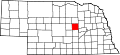
Hall County 079 Grand Island 1858 Un-Organized Augustus Hall, the chief justice of the Territorial Supreme Court at the time the county was created 8 53,534 546 sq mi
(1,414 km2)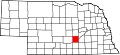
Hamilton County 081 Aurora 1867 Un-Organized Alexander Hamilton, the first United States Secretary of the Treasury 28 9,403 544 sq mi
(1,409 km2)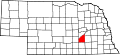
Harlan County 083 Alma 1871 Formed from Kearney Disputed; either James Harlan, who was the United States Secretary of the Interior in 1865 and 1866; or a revenue collector by the name of Harlan who once lived near Republican City, Nebraska 51 3,786 553 sq mi
(1,432 km2)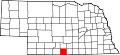
Hayes County 085 Hayes Center 1877 Un-Organized Rutherford Birchard Hayes, the nineteenth president of the United States 79 1,068 713 sq mi
(1,847 km2)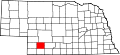
Hitchcock County 087 Trenton 1873 Un-Organized Phineas Warren Hitchcock, a U.S. Senator from Nebraska 67 3,111 710 sq mi
(1,839 km2)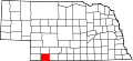
Holt County 089 O'Neill 1860 Un-Organized (Formerly- West County) Joseph Holt, a U.S. Postmaster General and U.S. Secretary of War under James Buchanan 36 11,551 2,413 sq mi
(6,250 km2)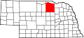
Hooker County 091 Mullen 1889 Un-Organized Joseph Hooker, an American Civil War general 93 783 721 sq mi
(1,867 km2)
Howard County 093 Saint Paul 1871 Formed from Hall County Oliver Otis Howard, an American Civil War general 49 6,567 570 sq mi
(1,476 km2)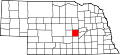
Jefferson County 095 Fairbury 1856 Un-organized Thomas Jefferson, the third president of the United States 33 8,333 573 sq mi
(1,484 km2)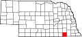
Johnson County 097 Tecumseh 1857 Formed from Nemaha and Otoe Counties Richard Mentor Johnson, the ninth vice president of the United States 57 4,488 376 sq mi
(974 km2)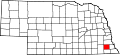
Kearney County 099 Minden 1860 Un-Organized Named for Fort Kearny - when the county was created the fort's name was misspelled 52 6,882 516 sq mi
(1,336 km2)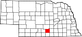
Keith County 101 Ogallala 1873 Un-Organized M. C. Keith, who owned one of the largest ranches in western Nebraska at the time 68 8,875 1,061 sq mi
(2,748 km2)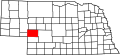
Keya Paha County 103 Springview 1884 Formed from Brown County and Un-Organized (Indian Territory) Dakota words Ké-ya Pa-há Wa-kpá, which, translated, mean turtle hill river 82 983 773 sq mi
(2,002 km2)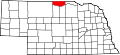
Kimball County 105 Kimball 1888 Formed from Cheyenne County Thomas L. Kimball, an official of the Union Pacific Railroad 71 4,089 952 sq mi
(2,466 km2)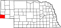
Knox County 107 Center 1857 Formed from Pierce County and Un-Organized (Formal names-L'Eau Qui Court (1857-1867) and Emmet (1867-1873)) Henry Knox, the first United States Secretary of War 12 9,374 1,108 sq mi
(2,870 km2)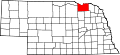
Lancaster County 109 Lincoln 1855 Formed from Cass, and Pierce Counties The cities of Lancaster, Pennsylvania and Lancaster, England. 2 250,291 839 sq mi
(2,173 km2)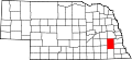
Lincoln County 111 North Platte 1860 Un-Organized (Formerly Shorter County) Abraham Lincoln, the sixteenth president of the United States 15 34,632 2,564 sq mi
(6,641 km2)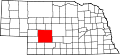
Logan County 113 Stapleton 1885 Un-Organized John Alexander Logan, a general in the American Civil War 87 774 571 sq mi
(1,479 km2)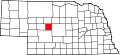
Loup County 115 Taylor 1883 Un-Organized Loup River which in turn is named for the French word loup which means wolf 88 712 570 sq mi
(1,476 km2)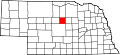
Madison County 119 Madison 1856 Formed from Loup County and McNeale Counties and Un-Organized Either James Madison, the fourth president of the United States; or, more likely, Madison, Wisconsin, where most of the new county's settlers were from 7 35,226 573 sq mi
(1,484 km2)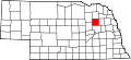
McPherson County 117 Tryon 1887 Un-Organized James Birdseye McPherson, a general in the American Civil War 90 533 859 sq mi
(2,225 km2)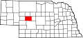
Merrick County 121 Central City 1858 Formed from Polk County and Un-Organized Elvira Merrick, wife of Henry W. DePuy, a territorial legislator 46 8,204 485 sq mi
(1,256 km2)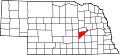
Morrill County 123 Bridgeport 1908 Formed from Cheyenne County Charles Henry Morrill, a president of the Lincoln Land Company 64 5,440 1,424 sq mi
(3,688 km2)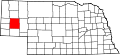
Nance County 125 Fullerton 1879 Formed from Pawnee Reservation Albinus Nance, the fourth governor of Nebraska 58 4,038 441 sq mi
(1,142 km2)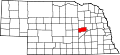
Nemaha County 127 Auburn 1854 One of Nine original counties (Formerly Forney) Nimaha, the Oto name meaning miry water for a stream which crossed the county and emptied into the Missouri River 44 7,576 409 sq mi
(1,059 km2)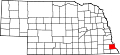
Nuckolls County 129 Nelson 1860 Un-Organized Lafayette Nuckolls, a member of the first Nebraska territorial legislature; and his brother, Stephen Nuckolls, a pioneering Nebraska settler, businessman and banker 42 5,057 575 sq mi
(1,489 km2)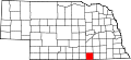
Otoe County 131 Nebraska City 1854 One of nine Original Counties (Formerly Pierce) Oto (also Otoe) Native American tribe 11 15,396 616 sq mi
(1,595 km2)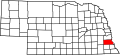
Pawnee County 133 Pawnee City 1855 Formed from Richardson County Pawnee Native American tribe 54 3,087 432 sq mi
(1,119 km2)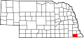
Perkins County 135 Grant 1887 Formed from Kieth County Charles E. Perkins, a president of the Chicago, Burlington and Quincy Railroad 74 3,200 883 sq mi
(2,287 km2)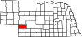
Phelps County 137 Holdrege 1873 Formed from Kearney County William Phelps, a riverboat captain on the Mississippi River who is alleged to have settled in the area 37 9,747 540 sq mi
(1,399 km2)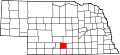
Pierce County 139 Pierce 1856 Formed from Izard County, McNeale County and Un-Organized Franklin Pierce, the fourteenth president of the United States 40 7,857 574 sq mi
(1,487 km2)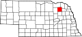
Platte County 141 Columbus 1856 Formed from Greene and Loup Counties Platte River which is in turn named for the French word for flat 10 31,662 678 sq mi
(1,756 km2)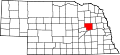
Polk County 143 Osceola 1856 Formed from York County and Un-Organized James Knox Polk, the eleventh president of the United States 41 5,639 439 sq mi
(1,137 km2)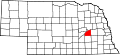
Red Willow County 145 McCook 1873 Un-Organized Red Willow Creek, which runs through the area 48 11,448 717 sq mi
(1,857 km2)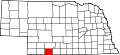
Richardson County 147 Falls City 1854 One of Nine Original Counties William A. Richardson, a governor of the Nebraska Territory 19 9,531 554 sq mi
(1,435 km2)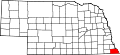
Rock County 149 Bassett 1885 Formed from Brown County Either Rock Creek, which flows in the county; or the rocky condition of the soil in the area 81 1,756 1,008 sq mi
(2,611 km2)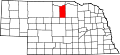
Saline County 151 Wilber 1867 Un-organized Named for a belief held by the early pioneers that great salt springs and deposits could be found in the area, a hope found to be false 22 13,843 575 sq mi
(1,489 km2)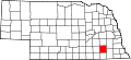
Sarpy County 153 Papillion 1857 Formed from Cass and Douglas Counties Peter A. Sarpy, a commander of a trading post in the future county 59 122,595 241 sq mi
(624 km2)
Saunders County 155 Wahoo 1856 Formed from Douglas and Lancaster (Formerly Calhoun County (1856-1865)) Alvin Saunders, a governor of the Nebraska Territory 6 19,830 754 sq mi
(1,953 km2)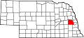
Scotts Bluff County 157 Gering 1888 Formed from Cheyenne County Named for a towering bluff located in the Scotts Bluff National Monument; the bluffs themselves are named for Hiram Scott, a fur trapper who is alleged to have crawled 75 miles with a broken leg before collapsing and dying at the foot of the formation 21 36,951 739 sq mi
(1,914 km2)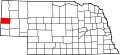
Seward County 159 Seward 1855 Formed from Cass and Pierce Counties (Formerly- Greene County) William Henry Seward, the United States Secretary of State during the 1860s 16 16,496 575 sq mi
(1,489 km2)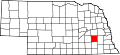
Sheridan County 161 Rushville 1885 Formed from Sioux County Philip Henry Sheridan, a general in the American Civil War 61 6,198 2,441 sq mi
(6,322 km2)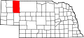
Sherman County 163 Loup City 1871 Formed from Buffalo County and Un-Organized William Tecumseh Sherman, the American Civil War general 56 3,318 566 sq mi
(1,466 km2)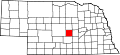
Sioux County 165 Harrison 1877 Un-Organized Sioux Native American tribe 80 1,475 2,067 sq mi
(5,354 km2)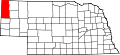
Stanton County 167 Stanton 1855 Formed from Burt County (Formerly Izard County) Edwin McMasters Stanton, the United States Secretary of War during most of the American Civil War 53 6,455 430 sq mi
(1,114 km2)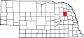
Thayer County 169 Hebron 1871 Formed from Jefferson County John Milton Thayer, the seventh governor of Nebraska 32 6,055 575 sq mi
(1,489 km2)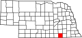
Thomas County 171 Thedford 1887 Un-Organized George Henry Thomas, a general in the American Civil War 89 729 713 sq mi
(1,847 km2)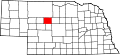
Thurston County 173 Pender 1889 Formed form Blackbird County and Omaha Reservation John Mellen Thurston, a U. S. senator from Nebraska 55 7,171 394 sq mi
(1,020 km2)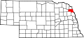
Valley County 175 Ord 1871 Un-Organized Named for the many valleys in the area 47 4,647 568 sq mi
(1,471 km2)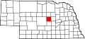
Washington County 177 Blair 1854 One of Nine Original Counties George Washington, the first president of the United States 29 18,780 390 sq mi
(1,010 km2)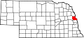
Wayne County 179 Wayne 1867 Un-Organized Anthony Wayne, the American Revolutionary War general nicknamed "Mad Anthony" by his troops 27 9,851 444 sq mi
(1,150 km2)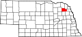
Webster County 181 Red Cloud 1867 Un-organized Daniel Webster, the statesman and U.S. Senator from Massachusetts 45 4,061 575 sq mi
(1,489 km2)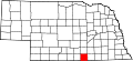
Wheeler County 183 Bartlett 1877 Un-Organized Daniel H. Wheeler, a secretary of the Nebraska State Board of Agriculture 84 886 575 sq mi
(1,489 km2)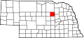
York County 185 York 1855 Formed from Cass County, Pierce County and Un-Organized Named for either York, England, or York County, Pennsylvania 17 14,598 576 sq mi
(1,492 km2)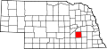
Former counties of Nebraska:
- Clay (1855-64) Formed from Un-organized and dissolved into Gage and Lancaster County.
- Jackson (1855-6) Formed from Un-Organized and dissolved to the Fillmore County and Un-Organized.
- Johnson (1855-6) Formed from Un-Organized and dissolved to Un-organized
- Blackbird (1855-88) Formed from Burt County and dissolved to Thurston County
- Loup (1855-6) Formed from Burt and Un-Organized and then dissolved Madison, Monroe and Platte Counties
- Jones (1856-66) Formed from Un-Organized and dissolved into Jefferson County.
- Grant, Harrison, Jackson, Lynn, Monroe and Taylor counties listed in 1870 (But no proof on where)
Notes
- ^ "EPA County FIPS Code Listing". EPA.gov. http://www.epa.gov/enviro/html/codes/ne.html. Retrieved 2008-05-04.
- ^ a b c d National Association of Counties. "NACo - Find a county". http://www.naco.org/Template.cfm?Section=Find_a_County&Template=/cffiles/counties/state.cfm&state.cfm&statecode=NE. Retrieved 2008-05-04.
- ^ The license plate prefix sequence is derived from the number of vehicles registered in each county in 1922.
 State of Nebraska
Topics - History
- Governors
- People
- Geography
- Congressional districts maps
- Visitor Attractions
Society - Culture
- Crime
- Demographics
- Economy
- Education
- Politics
Regions - Dissected Till Plains
- Lincoln metropolitan area
- Nebraska Outback
- Omaha metropolitan area
- Panhandle
- Pine Ridge
- Rainwater Basin
- Sand Hills
- Siouxland
- Wildcat Hills
Largest cities Counties - Adams
- Antelope
- Arthur
- Banner
- Blaine
- Boone
- Box Butte
- Boyd
- Brown
- Buffalo
- Burt
- Butler
- Cass
- Cedar
- Chase
- Cherry
- Cheyenne
- Clay
- Colfax
- Cuming
- Custer
- Dakota
- Dawes
- Dawson
- Deuel
- Dixon
- Dodge
- Douglas
- Dundy
- Fillmore
- Franklin
- Frontier
- Furnas
- Gage
- Garden
- Garfield
- Gosper
- Grant
- Greeley
- Hall
- Hamilton
- Harlan
- Hayes
- Hitchcock
- Holt
- Hooker
- Howard
- Jefferson
- Johnson
- Kearney
- Keith
- Keya Paha
- Kimball
- Knox
- Lancaster
- Lincoln
- Logan
- Loup
- Madison
- McPherson
- Merrick
- Morrill
- Nance
- Nemaha
- Nuckolls
- Otoe
- Pawnee
- Perkins
- Phelps
- Pierce
- Platte
- Polk
- Red Willow
- Richardson
- Rock
- Saline
- Sarpy
- Saunders
- Scotts Bluff
- Seward
- Sheridan
- Sherman
- Sioux
- Stanton
- Thayer
- Thomas
- Thurston
- Valley
- Washington
- Wayne
- Webster
- Wheeler
- York
Categories:- Lists of U.S. counties by state
- Nebraska counties
- Nebraska-related lists


Wikimedia Foundation. 2010.