- Iron Gate (Danube)
-
For the Iron Gates built by Alexander the Great in the Alexander Romance, see Gates of Alexander."Vaskapu" redirects here. For the village of Poarta Sălajului in Sălaj County, Romania, called Vaskapu in Hungarian, see Românaşi.
 The Iron Gates of the Danube
The Iron Gates (Romanian: Porţile de Fier pronounced [ˈport͡sile de ˈfjer]; [d͡ʑě̞rdaːp] or [d͡ʑě̞rdaːpskaː klǐsura]; Hungarian: Vaskapu; Slovak: Železné vráta; Turkish: Demirkapı; German: Eisernes Tor; Bulgarian: Железни врата, Zhelezni vrata) is a gorge on the Danube River. It forms part of the boundary between Romania and Serbia. In the broad sense it encompasses a route of 134 km (83 mi); in the narrow sense it only encompasses the last barrier on this route, just beyond the Romanian city of Orşova, that contains two hydroelectric dams, with two power stations, Iron Gate I Hydroelectric Power Station and Iron Gate II Hydroelectric Power Station.
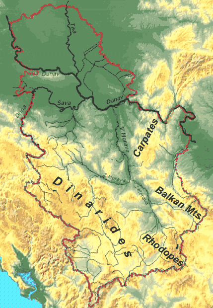
The gorge lies between Romania in the north and Serbia in the south. At this point, the river separates the southern Carpathian Mountains from the northwestern foothills of the Balkan Mountains. The Romanian, Hungarian, Slovakian, Turkish, German and Bulgarian names literally mean "Iron Gates" and are used to name the entire range of gorges. An alternative Romanian name for the last part of the route is Defileul Dunării, "Danube Gorge". In Serbia, the gorge is known as Đerdap (Ђердап), with the last part named Đerdapska klisura. The Romanian side of the gorge constitutes the Iron Gates natural park, whereas the Serbian part constitutes the Đerdap national park.
Contents
Gorges
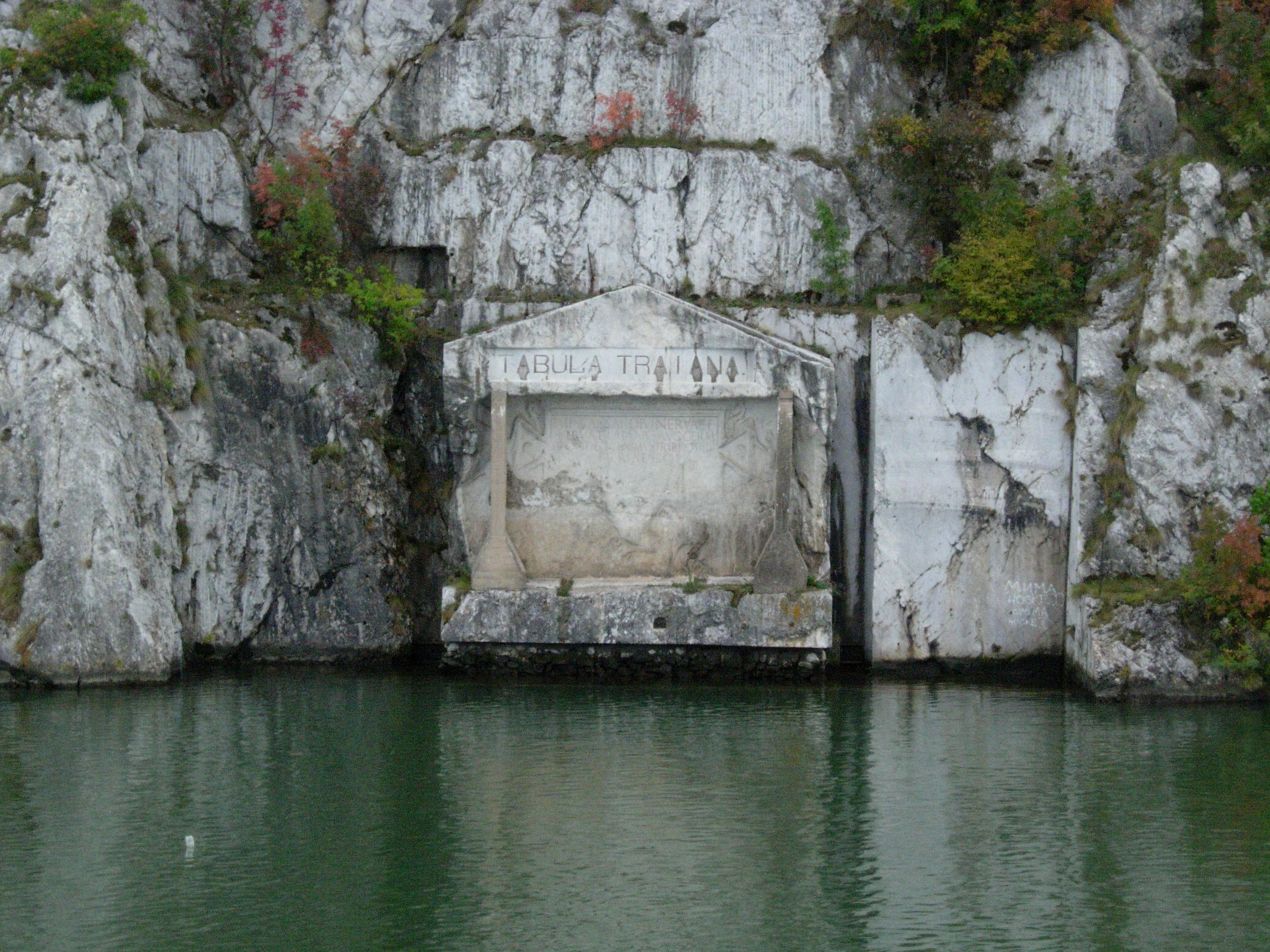
 The Roman plaque "Tabula Traiana", Serbia
The first narrowing of the Danube lies beyond the Romanian isle of Moldova Veche and is known as the Golubac gorge. It is 14.5 km long and 230 m (755 ft) wide at the narrowest point. At its head, there is a medieval fort at Golubac, on the Serbian bank. Through the valley of Ljupovska lies the second gorge, Gospodin Vir, which is 15 km long and narrows to 220 m (722 ft). The cliffs scale to 500 m and are the most difficult to reach here from land. The broader Donji Milanovac forms the connection with the Great and Small Kazan gorge, which have a combined length of 19 km (12 mi). The Orşova valley is the last broad section before the river reaches the plains of Wallachia at the last gorge, the Sip gorge.
The Great Kazan (kazan meaning "boiler") is the most famous and the most narrow gorge of the route: the river here narrows to 150 m and reaches a depth of up to 53 m (174 ft). East of this site the Roman emperor Trajan had the legendary bridge erected by Apollodorus of Damascus. Construction of the bridge ran from 103 through 105, preceding Trajan's conquest of Dacia. On the right bank a Roman plaque commemorates him. On the Romanian bank, at the Small Kazan, the likeness of Trajan's Dacian opponent Decebalus was carved in rock from 1994 through 2004.
Significantly older treasures have been unearthed in the geographically less spectacular gorge of Gospodin Vir: in the 1960s the archaeological survey Lepenski Vir was unearthed, the most significant in southeastern Europe. The sandstone statues from the early neolithic are particularly splendid. Along with the other surveys that can be found in the Iron Gates, it indicates that the region has been inhabited for a very long time.
 Kazan gorge at its narrowest point
Channel
The riverbed rocks and the associated rapids made the gorge valley an infamous passage in shipping. In German, the passage is still known as the Kataraktenstrecke, even though the cataracts are gone. Near the actual Iron Gates the Prigrada rock was the most important obstacle until 1896: the river widened considerably here and the water level was consequently low. Upstream, the Greben rock near the Kazan gorge was notorious.
In 1831 a plan had already been drafted to make the passage navigable, at the initiative of the Hungarian politician István Széchenyi. Finally Gábor Baross, Hungary's "Iron Minister", completed the financing for this project.
In 1890, beyond Orşova or Orsova in Hungarian,(Ursa in Romanian) being the last border town of Hungary, rocks were cleared by explosion over a 2 km (1.2 mi) stretch to create an 80 m (262 ft) wide and 3 m (10 ft) deep channel. A spur of the Greben Mountains was removed across a length of over 2 km (1.2 mi). Here, a depth of 2 m (7 ft) sufficed. On 17 September 1896, the Sip Channel thus created (named after the Serbian village on the right bank) was inaugurated by the Austro-Hungarian emperor Franz Joseph, the Romanian king Carol I, and the Serbian king Alexander Obrenovich.
The results of these efforts were slightly disappointing. The currents in the channel were so strong that, until 1973, ships had to be dragged upstream by locomotive. The Iron Gates thus remained an obstacle of note.
Dams
 Iron Gate I dam
The construction of the joint Romanian-Yugoslavian mega project that would finally tame the river commenced in 1964. In 1972 the Iron Gate I Dam was opened, followed by Iron Gate II Dam, in 1984, along with two hydroelectric power stations and two sluices.
The construction of these dams gave the valley of the Danube below Belgrade the nature of a reservoir, and additionally caused a 35 m rise in the water level of the river near the dam. The old Orşova, the Danube island Ada Kaleh (below) and at least five other villages, totaling a population of 17,000, had to make way. People were relocated and the settlements have been lost forever to the Danube.
The dam's construction had a major impact on the environment as well—for example, the spawning routes of several species of sturgeon were permanently interrupted.
That said, the flora and fauna, as well as the geomorphological, archaeological and cultural historical artifacts of the Iron Gates have been under protection from both nations since the construction of the dam. In Serbia this is done with the Đerdap National Park (since 1974, 636.08 km2 (245.59 sq mi)) and in Romania by the Porţile de Fier National Park (since 2001, 1,156.55 km2 (446.55 sq mi)).
Ada Kaleh
The isle of Ada Kaleh is probably the most evocative victim of the Đerdap dam's construction. A Turkish enclave, it had a mosque and a thousand twisting alleys, and was known as a free port and smuggler's nest. Many other ethnic groups lived there beside Turks.
The island was about 3 km (1.9 mi) downstream from Orşova and measured 1.7 by 0.4-0.5 km. It was walled; the Austrians built a fort there in 1669 to defend it from the Turks, and that fort would remain a bone of contention for the two empires. In 1699 the island came under Turkish control, from 1716 to 1718 it was Austrian, after a four month siege in 1738 it was Turkish again, followed by the Austrians reconquering it in 1789, only to have to yield it to the Turks in the following peace treaty. Thereafter, the island lost its military importance. The 1878 Congress of Berlin forced the Ottoman Empire to retreat far into the south, and the island came under the control of Austria-Hungary, though it remained the property of the Turkish sultan. The inhabitants enjoyed exemption from taxes and customs and were not conscripted. In 1923, when the Ottoman monarchy had disappeared, the inhabitants chose to join Romania.
The Ada Kaleh mosque dated from 1903 and was built on the site of an earlier Franciscan monastery. The carpet, a gift from the Turkish sultan, has been located in the Constanţa mosque since 1965.
Most Ada Kaleh inhabitants emigrated to Turkey after the evacuation of the island. A smaller part went to Dobrogea, another Romanian territory with a Turkish minority.
Cultural references and uses
Literature
- The pre-historic settings of the Earth's Children book series focuses in on difficulties traveling through or around the Iron Gates in both the second ("The Valley of Horses") and fourth ("The Plains of Passage") novels during scene sequences detailing travel adventures whilst the protagonists navigate between the upper and lower Danube valleys.
- The book Between the Woods and the Water by Patrick Leigh Fermor describes a night on the now submerged island Ada Kaleh and a trip by ferry through the Iron Gates, in August, 1934.
Film
- The 2003 film Donau, Duna, Dunaj, Dunav, Dunarea contains several minutes of film of the Iron Gates.
See also
- Commissions of the Danube River
- Danube River Conference of 1948
- Defile (geography)
- Energy in Romania
External links
- (Romanian) Porţile de Fier National Park
- (Serbian) Lepenski Vir
- (German) Ada Kaleh, die Inselfestung, also the source of the Ada Kaleh section in this article
Coordinates: 44°40′16″N 22°31′47″E / 44.67111°N 22.52972°E
National parks of Serbia 
Đerdap · Fruška Gora · Kopaonik · Šar Mountains · Tara

Protected areas of Romania Biosphere reserve National parks Călimani · Ceahlău · Cheile Bicazului-Hăşmaş · Cheile Nerei-Beuşniţa · Domogled-Valea Cernei · Măcin Mountains · Piatra Craiului Mountains · Semenic-Cheile Caraşului · Vânători-NeamţNature parks Apuseni Mountains · Balta Mică a Brăilei · Bucegi Mountains · Grădiştea Muncelului-Cioclovina · Iron GatesBridges of the Danube Upstream
Smederevo BridgeIron Gates Downstream
Trajan's BridgeCategories:- Canyons and gorges of Romania
- Canyons and gorges of Serbia
- Danube


Wikimedia Foundation. 2010.