- Kootenay River
Geobox River
name = Kootenay River
native_name =
other_name = Kootenai River
other_name1 =
image_size =
image_caption =
country = Canada
country1 = United States
state = Montana
state1 = Idaho
region_type = Province
region =British Columbia
region1 =
city = Bonners Ferry, ID
city1 = Creston, BC
city2 = Nelson, BC
city3 = Castlegar, BC
length_imperial = 485
length_note = [http://www.nwcouncil.org/fw/subbasinplanning/kootenai/plan/ Kootenai Subbasin Plan] , Northwest Power and Conservation Council]
watershed_imperial = 19420
watershed_round = -2
watershed_note =
discharge_location = mouth
discharge_imperial = 30650
discharge_max_imperial =
discharge_min_imperial =
discharge_note =
source_name = Rocky Mountains
source_location = Kootenay National Park
source_district =
source_region = British Columbia
source_state =
source_country = Canada
source_lat_d =
source_lat_m =
source_lat_s =
source_lat_NS =
source_long_d =
source_long_m =
source_long_s =
source_long_EW =
source_coordinates_note =
source_elevation_imperial =
source_elevation_note =
source_length_imperial =
mouth_name = Columbia River
mouth_location = Castlegar
mouth_district =
mouth_region = British Columbia
mouth_state =
mouth_country = Canada
mouth_lat_d = 49
mouth_lat_m = 19
mouth_lat_s = 0
mouth_lat_NS = N
mouth_long_d = 117
mouth_long_m = 39
mouth_long_s = 4
mouth_long_EW = W
mouth_coordinates_note = Gnis|384301|Kootenai River, USGS, GNIS]
mouth_elevation_imperial = 1377
mouth_elevation_note = cite web | title = The Rivers - Stories | publisher = Balance of Power | date = 2007 | url= http://virtualmuseum.ca/Exhibitions/Hydro/en/stories/rivers.php | accessdaymonth = September 3, | accessyear = 2008]
tributary_left = Palliser River
tributary_left1 = White River
tributary_left2 = Bull River
tributary_left3 = Elk River
tributary_left4 = Fisher River
tributary_right = St Mary River
tributary_right1 = Yaak River
tributary_right2 = Moyie River
tributary_right3 = Goat River
tributary_right4 = Duncan River
tributary_right5 = Slocan River
free_name =
free_value =
map_size = 300
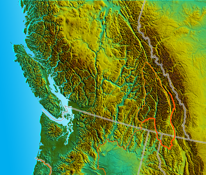
map_caption = Location map of Kootenay River. Columbia River shown in orange; lakes and reservoirs not shown.
map1 = Kootenay River Map.png
map1_caption = Map of the Kootenay River, its main tributaries and lakes, and select cities.Columbia River , flowing throughBritish Columbia ,Montana andIdaho . It is one of the few rivers inNorth America which begins in Canada, enters the United States and then reenters Canada.Course
The Kootenay originates in the
Rocky Mountains of eastern British Columbia, and initially flows south throughKootenay National Park , merging into theRocky Mountain Trench nearCanal Flats, British Columbia (here it passes within a kilometer ofColumbia Lake , the headwaters of the Columbia). It continues southwards along the Trench towards theUnited States border, and atWardner, British Columbia , it widens into theLake Koocanusa reservoir created by theLibby Dam nearLibby, Montana . Koocanausa spans theCanada -U.S. border; below the dam the river resumes (using the "Kootenai" spelling), veers westwards out of the Rocky Mountain Trench, collects the tributary Fisher River,Yaak River , andMoyie River , crosses into Idaho, passes through Bonners Ferry, then turns northwards again. It re-enters Canada south ofCreston, British Columbia , and widens intoKootenay Lake . AtNelson, British Columbia the Kootenay becomes a river again, now flowing southwest towards Castlegar, where it joins theColumbia River .The Kootenay River is convert|780|km|mi|0 long. Its
drainage basin is convert|50200|km2|sqmi large, of which convert|37700|km2|sqmi are in Canada and convert|12600|km2|sqmi|-1 are in the United States. [http://virtualmuseum.ca/Exhibitions/Hydro/en/stories/rivers.php The Rivers] , Balance of Power: Hydroelectric Development in Southeastern British Columbia; Touchstones Nelson: Museum of Art and History]The river is a Class I water from the Libby Dam downstream to the Idaho border for the purposes of public access for recreational purposes [ [http://fwp.mt.gov/content/getItem.aspx?id=24929 Stream Access in Montana] ] .
History
The Kootenay River is named for the indigenous Kootenai people. In written records from the early 19th century the Kootenai people were sometimes called the Flatbows, and the river called the Flatbow River. David Thompson traveled down the river in 1808 as part of his effort to establish a fur trading district in the Columbia River system. In 1809 Thompson named the river McGillivray's River, in honor of
Duncan McGillivray andWilliam McGillivray , partners of theNorth West Company who had strongly supported Thompson's work. [BCGNIS|6256|Kootenay Lake] [cite book |last= Nisbet |first= Jack |title= Sources of the River: Tracking David Thompson Across Western North America |year= 1994 |publisher= Sasquatch Books |isbn= 1-57061-522-5 |pages= pp. 130-131]In the 1970s, it was proposed that the Kootenay River be diverted into the Columbia River (the two rivers are separated by a distance of no more than one mile in the Rocky Mountain Trench in southeastern British Columbia). This would allow for the generation of increased hydroelectric power. The proposal was strongly opposed by both environmentalists as well as local residents. The economy of southeastern British Columbia is strongly dependent on tourism, with the Columbia River, including Columbia Lake and Windermere Lake, being very popular for summer swimming and boating activities. Diversion of the glacier-fed Kootenay River would have resulted in the Columbia River becoming much deeper and colder, flooding lake-side residences and damaging tourism. As a result, this proposed river diversion was never undertaken.Fact|date=July 2008
River modifications
A number of dams and related projects have been built on the Kootenay River, including Libby Dam in Montana, and, in Canada, Corra Linn (1932), Kootenay Canal (1976), Bonnington Falls (1906), Upper Bonnington (1907), Lower Bonnington (1897), South Slocan (1928), Brilliant (1944).
ee also
*
Kootenai disambiguation page
*Kootenay Lake
*List of rivers of Montana
*Montana Stream Access Law References
Wikimedia Foundation. 2010.