- Labrador
-
This article is about the region in Canada. For the dog breed, see Labrador Retriever. For other uses, see Labrador (disambiguation).
Labrador 

Flag of Labrador, with Coat of arms
(de facto)Motto: Munus splendidum mox explebitur (Latin)
"The splendid task will soon be fulfilled"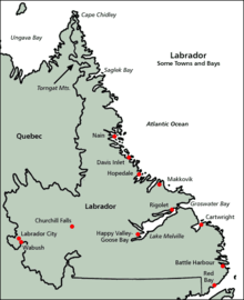

Geography Area: 294,330 square kilometres (113,640 sq mi) Water area: 31,340 km2 (12,100 sq mi) (4%) Coastline: 7,886 km (4,900 mi) Highest Point: Mount Caubvick
(1,652 m, 5,420 ft)Longest River: Churchill River
(856 km, 532 mi)Admin HQ: Happy Valley – Goose Bay Demographics Population (2006): 26,364[1] Density 0.09 /km2 Largest City: Happy Valley – Goose Bay[2] 7,572 (2006) Politics Government of Newfoundland & Labrador
http://www.gov.nl.caMembers of the Parliament of Canada: 1 Members of the Newfoundland and Labrador House of Assembly: 4 Labrador is the distinct, northerly region of the Canadian province of Newfoundland and Labrador. It comprises the mainland portion of the province, separated from the island of Newfoundland by the Strait of Belle Isle. It is the largest and northernmost geographical region in Atlantic Canada.
Labrador occupies the eastern part of the Labrador Peninsula, in an area slightly larger than the US state of Colorado. It is bordered to the west and the south by the Canadian province of Quebec. Labrador also shares a small land border with the Canadian territory of Nunavut on Killiniq Island.
Though Labrador's area is over twice that of the island of Newfoundland, it has only 6% of the province's population. The aboriginal peoples of Labrador include the Northern Inuit of Nunatsiavut, the Southern Inuit-métis of Nunatukavut (NunatuKavut), and the Innu. The non-aboriginal population in Labrador did not permanently settle in Labrador until the natural resource developments of the 1940s and 1950s. Before the 1950s, very few non-aboriginal people lived in Labrador year round. The few European immigrants who worked seasonally for foreign merchants and brought their families were known as Settlers.
Contents
Geography
 Natural-colour satellite image of an ice island off the coast of Labrador.
Labrador has a large, irregular, semi-triangular shape (see map at right) that encompasses the easternmost section of the Canadian Shield, a sweeping geographical region of thin soil and abundant mineral resources. Its western border with Quebec is the drainage divide of the Labrador peninsula. Lands that drain into the Atlantic Ocean are part of Labrador, while lands that drain into Hudson Bay are part of Quebec. Northern Labrador's climate is classified as polar, while Southern Labrador's climate is classified as subarctic.
Labrador can be divided into four geographical regions: the North Coast, Central Labrador, Western Labrador, and the South Coast. Each of those regions is described below.
Nunatsiavut
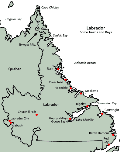
From Cape Chidley to Hamilton Inlet. The long thin northern tip of Labrador holds the Torngat Mountains, named after an Inuit spirit believed to inhabit them. The mountains stretch along the coast from Port Manvers to Cape Chidley, the northernmost point of Labrador. The Torngat Mountain range is also home to Mount Caubvick, the highest point in the province. This area is predominantly Inuit, with the small Innu community of Natuashish being the exception. The north coast is the most isolated region of Labrador, with snowmobiles, boats, and planes being the only modern modes of transportation. The largest community in this region is Nain.
Nunatsiavut is an Inuit self-government region in Labrador created on June 23, 2000. The Settlement area comprises the majority of Labrador's North Coast, while the land-use area also includes land farther to the interior and in Central Labrador. Nain is the adminstrative center of Nunatsiavut.
Central Labrador
The most populous region of Labrador, Central Labrador extends from the shores of Lake Melville into the interior. It contains the Churchill River, the largest river in Labrador and one of the largest in Canada. The hydroelectric dam at Churchill Falls is the second largest underground power station in the world, but most of the supply is bought by Hydro-Québec under a long-term contract. The Lower Churchill Project will develop the remaining potential of the river and supply it to provincial consumers. Known as "the heart of the Big Land", the area's population comprises people from all groups and regions of Labrador.
Central Labrador is also home to Happy Valley – Goose Bay, the largest community in Labrador. Once a refueling point for plane convoys to Europe in World War II, CFB Goose Bay is now a NATO tactical flight training site and was an alternate landing zone for the Space Shuttle.
Western Labrador
The highlands above the Churchill Falls was once an ancient hunting ground for the Innu First Nations and settled trappers of Labrador. After the construction of the hydroelectric dam at Churchill Falls in 1970, the Smallwood Reservoir has flooded much of the old hunting land, and submerged several gravesites and trapping cabins. Western Labrador is also home to the Iron Ore Company of Canada, which operates a large iron ore mine in Labrador City. Together with the small community of Wabush, the two towns are known as “Labrador West”.
NunatuKavut
From Hamilton Inlet to Cape Charles/St. Lewis. Nunatukavut is the territory of the Central-Southern Labrador Inuit, formerly known as the Labrador Metis. The region is peppered with tiny Inuit fishing communities, of which Cartwright is the largest. The Wonderstrands, miles of sandy white beaches at the mouth of the Hamilton Inlet south to Sandwich Bay, were mentioned in the ancient Viking sagas.
The Straits
From Cape Charles to the Quebec/Labrador coastal border. Like NunatuKavut, the straits is also known for its Labrador seagrass and the multitude of icebergs that pass by the coast via the Labrador Current. Red Bay is known one of the best examples of a preserved 16th Century Basque Whaling Station. It is also the location of four 16th-Century Basque Spanish Galleons. The lighthouse in L’Anse Amour is the second largest lighthouse in Canada. Passenger Ferry service to the island of Newfoundland is out of St. Barbe near the Quebec/Labrador border.
Modern Labrador
As with its island neighbour Newfoundland, early settlement in Labrador was tied to the sea as demonstrated by the Montagnais, Innu and Inuit, although these peoples also made significant forays throughout the interior as well. European settlement was largely concentrated in coastal communities, particularly those south of St. Lewis and Cape Charles, and are among Canada's oldest European settlements. The Moravian Brethren of Herrnhut, Saxony, first came to the Labrador Coast in 1760 to minister to the migratory Inuit tribes there. They founded Nain, Okak, Hebron, Hopedale and Makkovik. Extremely poor, both European and First Nations settlements along coastal Labrador came to benefit from cargo and relief vessels that were operated as part of the Grenfell Mission (see Wilfred Grenfell). Throughout the 20th century, coastal freighters and ferries operated initially by the Newfoundland Railway and later Canadian National Railway/CN Marine/Marine Atlantic became a critical lifeline for communities on the coast, which for the majority of that century did not have any road connection with the rest of North America.
Labrador played strategic roles during both World War II and the Cold War. In October 1943, a German U-boat crew installed an automated weather station on the northern tip of Labrador near Cape Chidley, code–named Weather Station Kurt; this was the only armed, German military operation on the North American mainland during the war. The station broadcast weather observations to the German navy for only a few days, but was not discovered until the 1980s when a historian, working with the Canadian Coast Guard, identified its location and mounted an expedition to recover it. The station is now exhibited in the Canadian War Museum.[3]
The Canadian government built a major air force base at Goose Bay, at the head of Lake Melville during the Second World War, a site selected because of its topography, access to the sea, defensible location, and minimal fog. During the Second World War and the Cold War, the base was also home to American, British, and later German, Dutch, and Italian detachments. Today, CFB Goose Bay is the largest employer for the community of Happy Valley – Goose Bay.
Additionally, both the Royal Canadian Air Force and United States Air Force built and operated a number of radar stations along coastal Labrador as part of the Pinetree Line, Mid-Canada Line and DEW Line systems. Today the remaining stations are automated as part of the North Warning System, however the military settlements during the early part of the Cold War surrounding these stations have largely continued as local Innu and Inuit populations have clustered near their port and airfield facilities.
During the first half of the 20th century, some of the largest iron ore deposits in the world were discovered in the western part of Labrador and adjacent areas of Quebec. Deposits at Mont Wright, Schefferville, Labrador City, and Wabush drove industrial development and human settlement in the area during the second half of the 20th century.
The present community of Labrador West is entirely a result of the iron ore mining activities in the region. The Iron Ore Company of Canada operates the Quebec North Shore and Labrador Railway to transport ore concentrate 800 kilometres (500 mi) south to the port of Sept-Îles, Quebec, for shipment to steel mills in North America and elsewhere.
During the 1960s, the Churchill River (Labrador name: Grand River) was diverted at Churchill Falls, resulting in the flooding of an enormous area – today named the Smallwood Reservoir after Joey Smallwood, the first premier of Newfoundland. The flooding of the reservoir destroyed large areas of habitat for the threatened Woodland Caribou. Both a hydroelectric generating station and a transmission line were built in the neighbouring province of Quebec.
From the 1970s to early 2000s, the Trans-Labrador Highway was built in stages to connect various inland communities with the North American highway network at Mont Wright, Quebec (which in turn is connected by a highway running north from Baie-Comeau, Quebec). A southern extension of this highway has opened in stages during the early 2000s and is resulting in significant changes to the coastal ferry system in the Strait of Belle Isle and southeastern Labrador. These "highways" are so called only because of their importance to the region; they would be better described as roads, and are not completely paved.
A study on a fixed link to Newfoundland, in 2004, recommended that a tunnel under the Strait of Belle Isle, being a single railway that would carry cars, buses and trucks, was technologically the best option for such a link. However, the study also concluded that a fixed link was not economically viable. Conceivably, if built with federal aid, the 1949 terms of union would be amended to remove ferry service from Nova Scotia to Port aux Basques across the Cabot Strait.
Although a highway link has, as of 16 December 2009, been completed across Labrador, this route is somewhat longer than a proposed Quebec North Shore highway that presently does not exist. Part of the "highway", Route 389, starting approximately 212 kilometres (132 mi) from Baie-Comeau to 482 kilometres (300 mi), is of an inferior alignment, and from there to 570 kilometres (350 mi), the provincial border, is an accident-prone section notorious for its poor surface and sharp curves. Quebec in April 2009 announced major upgrades to Route 389 to be carried out.
Route 389 and the Trans-Labrador Highway were added to Canada's National Highway System in September 2005.
Labrador constitutes a federal electoral district electing one member to the House of Commons of Canada. Due to its size, distinct nature, and large Aboriginal population, Labrador has one seat despite having the smallest population of any electoral district in Canada. Formerly, Labrador was part of a riding that included part of the Island of Newfoundland. Labrador is divided into four provincial electoral districts in the Newfoundland and Labrador House of Assembly.
Time zone
Officially, all of Newfoundland and Labrador uses Newfoundland Time (UTC-3:30 in winter, UTC-2:30 in summer). However, in practice, most of Labrador (from Cartwright north and west) uses Atlantic Time (UTC-4 in winter, UTC-3 in summer). The southwestern tip nearest the Island of Newfoundland uses Newfoundland Time to stay coordinated with the island.
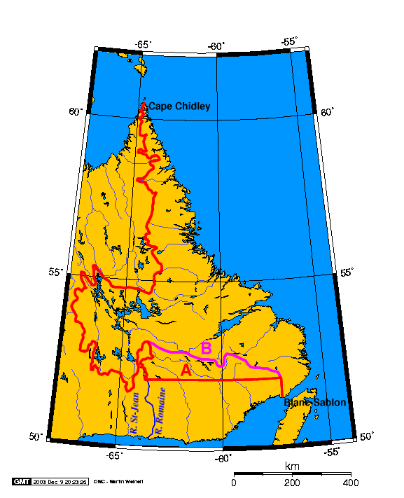
Boundary dispute
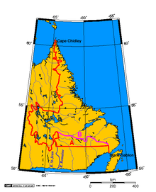 Line A: the boundary decided by the Privy Council; the current legal boundary. Line B: the boundary as it is sometimes portrayed by Quebec today.
The border between Labrador and Canada was set March 2, 1927, after a tortuous five-year trial. In 1809 Labrador had been transferred from Lower Canada to Newfoundland, but the landward boundary of Labrador had never been precisely stated.[4] Newfoundland argued it extended to the height of land, but Canada, stressing the historical use of the term "Coasts of Labrador", argued the boundary was 1 statute mile (1.6 km) inland from the high-tide mark. As Canada and Newfoundland were separate Dominions, but both members of the British Empire, the matter was referred to the Judicial Committee of the Privy Council (in London), which set the Labrador boundary mostly along the coastal watershed. One of Newfoundland's conditions for joining Confederation in 1949 was that this boundary be entrenched in the Canadian constitution. While this border has not been formally accepted by the Quebec government, the Henri Dorion Commission (Commission d'étude sur l'intégrité du territoire du Québec) concluded in the early 1970s that Quebec no longer has a legal claim to Labrador.[5]
In 2001, Québec Natural Resources Minister and Québec Intergovernmental Affairs Minister reasserted that Québec has never recognised the 1927 border:
"Les ministres rappellent qu'aucun gouvernement québécois n'a reconnu formellement le tracé de la frontière entre le Québec et Terre-Neuve dans la péninsule du Labrador selon l'avis rendu par le comité judiciaire du Conseil privé de Londres en 1927. Pour le Québec, cette frontière n'a donc jamais été définitivement arrêtée."[6]
(The ministers reiterate that no Quebec government has ever formally recognized the drawing of the border between Quebec and Newfoundland in the Labrador peninsula according to the opinion rendered by the privy council in 1927. For Quebec, this border has thus never been definitively defined.)
Possible separation from Newfoundland
A Royal Commission in 2002 determined that there is a certain amount of public pressure from Labradorians to break off from Newfoundland and become a separate province or territory. Some of the Innu nation would have the area become a homeland for them, much as Nunavut is for the Inuit; a 1999 resolution of the Assembly of First Nations claimed Labrador as a homeland for the Innu and demanded recognition in any further constitutional negotiations regarding the region.[7] The northern Inuit self-government region of Nunatsiavut was recently created through agreements with the provincial and federal governments. The Southern Inuit of Nunatukavut (NunatuKavut), who are also seeking self-government, have their land claim before the federal government. The provincial government of Newfoundland refuses to recognize or negotiate with the Inuit of NunatuKavut until their claim has been accepted by the federal government.
Timeline
- 11th century: Probable visit by Leif Ericson. See Markland.
- 1498: Sighted by João Fernandes Lavrador, who gave "Labrador" its name
- 1498: Visited by John Cabot
- 1500: Visited by Gaspar Corte-Real
- 1534: Visited by Jacques Cartier
- 1763: Labrador is transferred from the French colony Canada to the British colony Newfoundland as per the Treaty of Paris.
- 1774: Labrador is transferred (along with Anticosti Island and the Magdalen Islands) to the Province of Quebec.
- 1791: Labrador becomes part of Lower Canada when Quebec is divided into two colonies.
- 1792: George Cartwright publishes his Journal of Transactions and Events, During a Residence of Nearly Sixteen Years on the Coast of Labrador.
- 1809: Labrador (from Cape Chidley to the mouth of the Saint-Jean River) is transferred back to Newfoundland.
- 1825: The north shore of the Gulf of Saint Lawrence west of Blanc-Sablon, Quebec, and south of 52° north is separated from Labrador and transferred back to Lower Canada.
- 1892: Wilfred Grenfell, medical missionary and social activist, first came to Labrador.
- 1927: The Labrador boundary dispute is settled.
- 1941: Canada builds the air base at Goose Bay.
- 1949: Labrador becomes part of Canada when Newfoundland joins Confederation.
- 1964: The province's government began to refer to itself as the Government of Newfoundland and Labrador,
- 2001: The province officially changes its name to Newfoundland and Labrador by a Canadian constitutional amendment.
- 2007: The province and Federal Government of Canada sign an agreement to establish Nunatsiavut
Demographics
Largest towns in Labrador (incorporated towns only) Town 2006 2001 Happy Valley – Goose Bay 7,572 7,969 Labrador City 7,240 7,744 Wabush 1,739 1,894 Nain 1,034 1,159 L'Anse-au-Loup 593 635 Cartwright 552 629 Hopedale 530 559 North West River 492 551 Port Hope Simpson 529 509 Forteau 448 477 Demographic Factors (2001 Census)[8] Factor Labrador Canada Male/Female split 50.6/49.4 49.0/51.0 Median age 32.6 37.6 Percent foreign-born. 1.5% 18.4% Aboriginal pop. 34.9% 3.3% Religion - Catholic 28.4% 43.6% Religion - Protestant 67.4% 29.2% Religion - other 0.8% 10.6% No religion 3.4% 16.5% Median income (age 15+) $19,229 $22,120 Unemployment rate 19.1% 7.4% Natural features
Labrador is home to a number of fauna and flora species. Most of the Upper Canadian and Lower Hudsonian mammalian species are found in Labrador.[9] Notably the Polar bear, Ursus maritimus, reaches the southeast of Labrador on its annual migration.[10]
See also
- Landsat Island
- Nunatsiavut
- Torngat Mountains National Park
- Nunatukavut
References
- ^ "2006 Census Data - GeoSearch2006". Statistic Canada. 2008-06-26. http://geodepot.statcan.ca/GeoSearch2006/GeoSearch2006.jsp?resolution=H&lang=E&otherLang=F. Retrieved 2008-08-28.
- ^ "2006 Census". http://www12.statcan.ca/english/census06/data/profiles/community/Details/Page.cfm?Lang=E&Geo1=CSD&Code1=1010025&Geo2=PR&Code2=10&Data=Count&SearchText=Goose%20Bay&SearchType=Begins&SearchPR=10&B1=All&Custom=. Retrieved 2007-04-17.
- ^ "Weather station Kurt erected in Labrador in 1943". http://www.uboat.net/ops/weather_stations.htm. Retrieved 2010-02-18.
- ^ "LABRADOR-CANADA BOUNDARY". marianopolis. 2007. http://faculty.marianopolis.edu/c.belanger/NFLDHistory/Quebec-NewfoundlandLabradorBoundaryIssue.htm. Retrieved 2008-03-20. "Labrador Act, 1809. - An imperial act (49 Geo. III, cap. 27), 1809, provided for the re-annexation to Newfoundland of 'such parts of the coast of Labrador from the River St John to Hudson's Streights, and the said Island of Anticosti, and all other smaller islands so annexed to the Government of Newfoundland by the said Proclamation of the seventh day of October one thousand seven hundred and sixty-three (except the said Islands of Madelaine) shall be separated from the said Government of Lower Canada, and be again re-annexed to the Government of Newfoundland.'"
- ^ "The Ten Big Myths". Quebec National Assembly, First Session, 34th Legislature. October 17, 1991. http://classic-web.archive.org/web/20091026232154/www.geocities.com/Yosemite/Rapids/3330/constitution/hden.htm. Retrieved May 18, 2011.
- ^ "Communiqué du 31 octobre 2001 - Le ministre des Ressources naturelles du Québec et le ministre délégué aux Affaires intergouvernementales canadiennes expriment la position du Québec relativement à la modification de la désignation constitutionnelle de Terre-Neuve". saic.gouv.qc.ca. Gouvernement du Quebec. October 31, 2001. http://www.saic.gouv.qc.ca/centre_de_presse/communiques/2001/saic_com20011031.htm#. Retrieved May 18, 2011.
- ^ "Resolution No. 11 - Innu Traditional Territory". Assembly of First Nations Resolutions 1999. Assembly of First Nations. July 20–23, 1999. http://64.26.129.156/article.asp?id=960. Retrieved May 18, 2011.
- ^ *Community Profile: Labrador: Division No. 10, Newfoundland and Labrador; Statistics Canada
- ^ The American Naturalist (1898) Essex Institute, American Society of Naturalists
- ^ C. Michael Hogan (2008) Polar Bear: Ursus maritimus, Globaltwitcher.com, ed. N. Stromberg
Further reading
- Low, Albert Peter (1896), "Report on explorations in the Labrador peninsula along the East Main, Koksoak, Hamilton, Manicuagan and portions of other rivers in 1892-93-94-95", Geological Survey of Canada (Ottawa: Queen's Printer), http://www.archive.org/details/reportonexplorat00geoluoft, retrieved 2010-09-13
- The Lure of the Labrador Wild, by Dillon Wallace (1905)
- Labrador by Choice, by Benjamin W. Powell Sr. C.M. 1979
- The Story of Labrador, by B. Rompkey (2005)
- Labrador, by Robert Stewart (1977)
External links
- Audio recording of a traditional ghost story from Labrador, Canada
- Project Gutenberg e-text of Dillon Wallace's The Lure of the Labrador Wild
- Labrador information page
- Trans-Labrador Highway website - detailed information about traveling in Labrador.
- Alexander Forbes Collection: Aerial photo survey of Labrador from 1931, 1932, and 1935 expeditions - University of Wisconsin-Milwaukee Libraries Digital Collections
 Subdivisions of Newfoundland and Labrador
Census divisions Cities Other communities Bishop's Falls · Bonavista · Botwood · Carbonear · Channel – Port aux Basques · Clarenville · Conception Bay South · Deer Lake · Ferryland · Fogo · Gander · Grand Bank · Grand Falls-Windsor · Happy Valley – Goose Bay · Harbour Grace · Hopedale · Labrador City · Marystown · Nain · Norris Arm · Pasadena · Peterview · Placentia · Red Bay · St. Anthony · Stephenville · Twillingate · Torbay · Woody Point · Makkovik Category:Newfoundland and Labrador ·
  Portal:Newfoundland and Labrador ·
  WikiProject:Newfoundland and Labrador
- Related navpages:
- {{Portuguese overseas empire}}
Categories:- Labrador
- Territorial disputes of Canada

Wikimedia Foundation. 2010.