- Cheadle Hulme
-
Coordinates: 53°22′34″N 2°11′23″W / 53.3761°N 2.1897°W
Cheadle Hulme 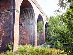
Part of the seven arches railway viaduct on Ladybridge Road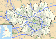
 Cheadle Hulme
Cheadle Hulme shown within Greater ManchesterPopulation 28,952 OS grid reference SJ872870 - London 157 mi (253 km) SE Metropolitan borough Stockport Metropolitan county Greater Manchester Region North West Country England Sovereign state United Kingdom Post town CHEADLE Postcode district SK8 Dialling code 0161 Police Greater Manchester Fire Greater Manchester Ambulance North West EU Parliament North West England UK Parliament Cheadle List of places: UK • England • Greater Manchester Cheadle Hulme is an area of the Metropolitan Borough of Stockport, in Greater Manchester, England.[1] It is 2.3 miles (3.7 km) southwest of Stockport and 7.5 miles (12.1 km) southeast of the city of Manchester. It lies in the Ladybrook Valley on the Cheshire Plain, and the drift consists mostly of boulder clay, sands and gravels. As of the 2001 census, it had a population of 29,000.
Evidence of Bronze Age, Roman, and Anglo-Saxon activity, including coins, jewellery and axes, has been discovered locally. Historically a part of Cheshire, the area was first mentioned in the Domesday Book of 1086 when it was a large estate which included neighbouring Cheadle. In the early 14th century it was split into southern and northern parts at about the future locations of Cheadle Hulme and Cheadle, respectively. The area was acquired by the Moseley family in the 17th century and became known as Cheadle Moseley. Unlike many English villages it did not grow around a church; instead it formed from several hamlets, many of which retain their names as neighbourhoods within Cheadle Hulme. In the late 19th century Cheadle Hulme was united with Cheadle, Gatley and other neighbouring places to form the urban district of Cheadle and Gatley. This district was abolished in 1974 and Cheadle Hulme became a distinct place in its own right, as part of the Metropolitan Borough of Stockport.
Cheadle Hulme remains part of the Metropolitan Borough, with its own schools, open parkland, historical landmarks such as Bramall Hall, shopping areas, and local businesses. These are sustained by its railway station, and its close proximity to Manchester Airport and major roads such as the A34.
Contents
History
Early history
The Domesday Book provides the earliest mention of the area, where it is recorded as "Cedde", Celtic for "wood".[2] Local archaeological finds include Bronze Age axes discovered in Cheadle. Evidence of Roman occupation includes coins and jewellery, which were discovered in 1972.[3] The modern-day Cheadle Road was originally known as Street Lane, and may be of Roman origin. A stone cross dedicated to the Anglo-Saxon St Chad, discovered in 1873, indicates Anglo-Saxon activity.[4] The cross was found in an area called "Chad Hill", on the banks of the Micker Brook near its confluence with the River Mersey; this area became "Chedle".[2][3] Suggestions for the origin of the name include the words cedde, and leigh or leah, in Old English meaning "clearing", forming the modern day "Cheadle".[5] "Holme" may have been derived from the Danish word for "water meadow" or "island in the fen".[6][7]
According to the Domesday Book in 1086, the modern-day Cheadle and Cheadle Hulme were a single large estate. Valued at £20,[8] it was described as "large and important" and "a wood three leagues [about 9 miles] long and half as broad".[4] One of the earliest owners of the property was the Earl of Chester. It was held by a Gamel, a free Saxon, under Hugh d'Avranches, 1st Earl of Chester, and later became the property of the de Chedle family, who took their name from the land they owned.[9] By June 1294 Geoffrey de Chedle was Lord of the Manor.[4] Geoffrey's descendant Robert (or Roger) died in the early 1320s, leaving the estate to his wife Matilda who held it until her death in 1326.[4] As there were no male heirs the manor, which was now worth £30 per annum,[10] was divided between her daughters, Clemence and Agnes.[11] Clemence inherited the southern half (which would later become the modern-day Cheadle Hulme), and Agnes inherited the northern half, (latterly Cheadle).[8] The two areas became known as "Chedle Holme" and "Chedle Bulkeley" respectively.[12] Shortly afterwards the Chedle Holme estate was divided and the part where Hulme Hall is now situated became known as "Holme", and held by the Vernons. The estates were reunified on the death of the last of the Vernons in 1476.[11]
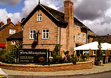
 The Hesketh Tavern, on Hulme Hall Road, is a public house. It was built on the site of another public house, the Horse & Jockey, in 1864 and named after the family who once owned the manor.
The only daughter of Clemence and William de Bagulegh, Isabel de Bagulegh, succeeded her parents as owner of the manor, and married Sir Thomas Danyers. Danyers was rewarded for his efforts in the crusades through an annual payment from the King of 40 marks, as well as the gift of Lyme Hall. His daughter Margaret continued to receive payments after his death.[12]
The first John Savage succeeded Margaret, and nine more followed him.[13] The tenth died young, so the estate passed to his brother, Thomas Savage. In 1626 Charles I created the title of Viscount Savage for him.[14] On his death the estate passed to his daughter Joan, who later married John Paulet, 5th Marquess of Winchester. Joan died during childbirth at the age of 23, and the estate passed to the Marquess. The Marquess practised Catholicism, and in 1643 the estate was confiscated due to persecution of Catholics in the English Civil War.[8]
Following this, the estate was acquired by the Moseley family of Manchester and became known as Cheadle Moseley. Anne Moseley was the last of this family to hold the manor, as her husband could not afford to keep it following her death. It was purchased by John Davenport, who bequeathed it to the Bamford family when he died childless in 1760. After the last Bamford died without male issue in 1806, the estate passed to Robert Hesketh who took the name Bamford-Hesketh;[8] it is from this family that the Hesketh Tavern public house in Cheadle Hulme got its name.[15] The last person to hold the manor was Winifred, Countess of Dundonald, one of Bamford-Hesketh's descendants.[8]
Modern history
In 1801 the population was 971 and had risen to 2,319 by 1851.[16] In 1868 the area became a parish,[17] but it was merged with Cheadle Bulkeley in 1879 and became part of the Cheadle and Gatley district in 1894.[18] The name "Cheadle Moseley" continued to be used for the area, and appeared on tithes and deeds until the 20th century.[8] In 1974, the Cheadle and Gatley district was abolished and Cheadle Hulme became part of the Metropolitan Borough of Stockport.[1]
During the Second World War, Cheadle Hulme was a refuge for evacuees from places such as Manchester and the Channel Islands. The area had its own Home Guard, as well as several air-raid shelters. Cheadle Hulme itself escaped being badly damaged, but its villagers knew the extent of the war and could hear the sounds of air-raids on Manchester.[19]
Cheadle Hulme did not grow around a church like many English villages, but instead grew from several hamlets that existed in the area. Many of the names of these hamlets still appear in the names of areas, including Smithy Green, Lane End, Gill Bent, and Grove Lane.[15] Some of the many farms such as Orish Mere Farm and Hursthead Farm which covered the area also retain their names in schools that were built in their place.[20]
Governance
Lying within the historic county boundaries of Cheshire, Cheadle Hulme was historically a township known as "Cheadle Moseley" in the ecclesiastical parish of Cheadle and Hundred of Stockport. Following the Municipal Corporations Act 1835, part of Cheadle Moseley was amalgamated into the Municipal Borough of Stockport. In 1879, the remaining part was merged with neighbouring Cheadle Bulkeley to form the township of Cheadle.[1]
Established in 1886, Cheadle Hulme's first local authority was the Cheadle and Gatley local board of health, a regulatory body responsible for standards of hygiene and sanitation for the area of Stockport Etchells township and the part of Cheadle township outside the Municipal Borough of Stockport. The board of health was also part of Stockport poor law union. In 1888 the board was divided into four wards: Adswood, Cheadle, Cheadle Hulme and Gatley.[21] Under the Local Government Act 1894 the area of the local board became Cheadle and Gatley Urban District. There were exchanges of land with the neighbouring urban districts of Wilmslow and Handforth in 1901, and the wards were restructured again, splitting Cheadle Hulme into north and south, and merging in Adswood.[21] Due to the fast-paced growth of the district, the wards were again restructured in 1930, with the addition of Heald Green. In 1940 the current wards of Adswood, Cheadle East, Cheadle West, Cheadle Hulme North, Cheadle Hulme South, Gatley and Heald Green were established.[22] Under the Local Government Act 1972 the Cheadle and Gatley Urban District was abolished, and Cheadle Hulme has, since 1 April 1974, formed an unparished area of the Metropolitan Borough of Stockport within the metropolitan county of Greater Manchester.[1]
Since 1950 Cheadle Hulme has been part of the Cheadle parliamentary constituency,[23] and has been represented by Liberal Democrat member Mark Hunter since 2005.[24] Six councillors, three representing Cheadle Hulme South ward and three representing Cheadle Hulme North, serve on the borough council.[25]
Geography
 The Micker Brook, running through fields behind the Ramillies estate
At 53°22′34″N 2°11′23″W / 53.376161°N -2.189713°E, Cheadle Hulme is in the south of Greater Manchester. Stockport Metropolitan Borough straddles the Cheshire Plain and the Pennines, and Cheadle Hulme is in the west of the borough on the Cheshire Plain. The area lies in the Ladybrook Valley next to the Micker Brook, a tributary of the River Mersey which flows north–west from Poynton through Bramhall and Cheadle Hulme, joining the Mersey in Stockport.[26] Cheadle Hulme is situated 2.3 miles (3.7 km) southwest of Stockport town centre, and 7.5 miles (12.1 km) southeast of Manchester city centre.
The majority of buildings in the area are houses from the 20th century, but there are a few buildings, landmarks, and objects that date from the 16th century, in addition to Bramall Hall which dates from the 14th century. In particular, there are many Victorian buildings in several places across the area. The local drift geology is mostly glacial boulder clay, as well as glacial sands and gravel. For many years the clay has been used for making bricks and tiles.[27]
Cheadle Hulme's climate is generally temperate, like the rest of Greater Manchester. The mean highest and lowest temperatures of 13.2 °C (55.8 °F) and 6.4 °C (43.5 °F) are slightly above the average for England, while the annual rainfall of 806.6 millimetres (31.76 in) and average hours (1,394.5 hours) of sunshine are respectively above and below the national averages.[28][29]
Neighbouring towns, villages and places 
Cheadle Cheadle Adswood Heald Green 
Bramhall  Cheadle Hulme

Handforth Woodford Bramhall Demography
- Note: Cheadle Hulme is split into two areas for censuses, Cheadle Hulme North and Cheadle Hulme South. The figures below account for both areas.
Cheadle Hulme compared 2001 UK census Cheadle Hulme Stockport (borough)[30] England Total population 28,952 284,528 49,138,831 White 95% 94.4% 90.9% Asian 2.5% 3.4% 4.6% Mixed 1.1% 0.9% 1.3% Chinese 1.0% 0.6% 0.9% Black 0.4% 0.6% 2.3% According to the Office for National Statistics, Cheadle Hulme had a population of 28,952 as of the United Kingdom Census 2001.[31][32] The population density was 8,425 inhabitants per square mile (3,253 /km2),[33][34] with a 100–92.5 female-to-male ratio. Of those aged over 16, 19.7% were single (never married) and 41% married.[35][36] Cheadle Hulme's 11,981 households included 27.6% one-person, 43.5% married couples living together, 6.5% were co-habiting couples, and 8.1% single parents with children.[37][38] Of those aged 16–74, 20.8% had no academic qualifications.[31][32]
About 76.5% of Cheadle Hulme's residents reported themselves as being Christian, 1.9% Muslim, 0.9% Jewish and 0.7% Hindu. The census recorded 12.3% as having no religion, 0.3% had an alternative religion and 7.2% did not state their religion.[39][40]
Population growth in Cheadle Moseley (from 1664–1871)[41] and Cheadle and Gatley (including Cheadle Hulme) from 1891 to 2001 Year 1664 1801 1811 1821 1831 1841 1851 1861 1871 1891 1901 1911 1921 1931 1939 1951 1961 1971 1981 1991 2001 Population 390 971 1,296 1,534 1,946 2,288 2,319 2,329 2,612 8,252 7,916 9,913 11,036 c. 5,550[Note 1] 32,245 31,511 45,621 60,807 59,828 58,457 57,507 Urban District 1891–1971[42] • Urban Subdivision 1981–2001[43][44][45] Economy
 Pimlott's butcher shop, on Station Road. It was established in 1869, and is one of the family-run businesses in the area.
For many years Cheadle Hulme was rural countryside,[46] made up of woods, open land, and farms. The local population was made up of farmers and peasants, living in small cottages and working the land under the tenancy of the Lord of the Manor.[47] Most families kept animals for food, grew their own crops,[46] and probably bought and sold produce at Stockport market.[47] Water was obtained from local wells and ponds, and sometimes the Micker Brook.[48]
Local silk weaving became a large part of everyday life. The work took place in domestic cottages in a room known as a "loomshop",[46] and the woven silk was transported to firms in Macclesfield 8 miles (13 km) away.[49] Silk-weaving remained commonplace in the area until the early 20th century, when the process became industrialised.[46] Other industries in the area included a corn mill, which collapsed some time during the First World War, located next to the Micker Brook; cotton weaving; and brickworks, one located where the fire station is and one near the railway station.[50] A coal wharf was situated opposite the railway station and supplied the area with coal.[51]
 Cheadle Hulme Fire Station on Turves Road, built in 1960. The site also incorporates an ambulance station.
The building of the railways in the early 1840s introduced new employment opportunities for people in places such as Stockport and Manchester, as well as an influx of people coming to live in the area.[48][52] In the mid-19th century, one of the earliest shops was opened in the Smithy Green area, selling groceries, sweets and other provisions.[46] As people settled in the area, more shops were opened and new houses were built, many of which still stand.[50] During the early 20th century Cheadle Hulme experienced a rapid growth in population, mostly due to an influx of people from Manchester and other large towns and cities coming to live in the area, and it gradually became more suburban.[53] In the 1930s more houses were built around the Grove Lane and Pingate Lane, Gill Bent Road, Hulme Hall Road and Cheadle Road areas, and new roads replaced old farms.[19][54] In the 1960s the Hursthead estate was built on land that was once Hursthead Farm.[55] As of 2009 the only farm remaining is Leather's Farm on Ladybridge Road.[56]
Cheadle Hulme is served by a fire station on Turves Road which opened in October 1960. Before this the area made use of a service in Cheadle.[57] An ambulance station is near the fire station, and the closest public hospital is Stepping Hill Hospital in Hazel Grove. Until the early 2000s the area had a police station which served as the headquarters for the west Stockport area.[58] The building, which opened in 1912, was sold in 2006 and converted into flats.[59]
 Waitrose, on Station Road. It was built in 2007 on the site of a former office block, and was Waitrose's first purpose-built retail outlet in northern England.
Cheadle Hulme has a large variety of businesses serving the area. Station Road is home to the shopping precinct (built in 1962)[60] and contains among other businesses a Halifax Bank, an Oxfam shop, a Somerfield, a newsagent, a hairdresser's shop, a furniture shop, an optician, a pharmacy, and several restaurants. There are more restaurants and cafés along Station Road as well as solicitors and building societies, and long-running family businesses such as Pimlott's butchers are also prominent.[61] In 2002 a Blockbuster and Tesco Express opened on the site of an old petrol station, and in July 2007 Cheadle Hulme became the home of Waitrose's first purpose-built retail outlet in northern England.[62]
According to the 2001 census, the biggest industry of employment for Cheadle Hulme residents is that of wholesale and retail trade and repairs with approximately 16% of people employed in that industry. This is followed closely by real estate, renting and business activities with 15% of people employed in this area. Other big areas of employment include manufacturing (13%), health and social work (11%), and education (10%).[63][64] Approximately 30% of people were classed as "economically inactive" in the 2001 census. This included retired people, people who had to look after their family, and disabled or sick people.[65][66]
Landmarks
 Bramall Hall, a 14th-century timber-framed manor house. It is a Grade I listed building.
Bramall Hall, a Grade I listed building, is a 14th-century black and white timber framed Tudor manor house, located between Cheadle Hulme and Bramhall.[67] Described by Stockport Metropolitan Borough Council (SMBC) as "the most prestigious and historically significant building in the Conservation Area",[68] it is situated in the middle of 70 acres (28 ha) of landscaped parkland featuring lakes, woodland and gardens. Both house and grounds are open to the public and are in one of the 19 conservation areas in the borough.[67]
The Swann Lane, Hulme Hall Road, and Hill Top Avenue conservation area contains 16th and 17th century timber-framed buildings, Victorian villas, churches, and some former farmsteads.[69] There are two Grade II listed buildings in this area: Hulme Hall, a timber-framed manor house which dates from either the 16th or 17th century, and 1 Higham Street, formerly Hill Cottage, which is of a similar period and style to Hulme Hall. The Church Inn public house, which dates from either the late 18th or early 19th century, is situated on the edge of this area.[52]
 The cenotaph, on Ravenoak Road. It is on the corner of a busy junction, and suggestions to move it to a more peaceful area have been made.
Around 300 men from Cheadle Hulme served in the First World War,[70] and it was decided that those who died should be commemorated. Various ideas, including a library and clock tower, were suggested and in the end a cenotaph was built on the corner of Ravenoak Road and Manor Road in 1921. Additions for later wars have been made, and due to the busy traffic around that particular place there have been suggestions for moving it to a quieter area.[71]
Bruntwood Park has a variety of facilities, including orienteering, an 18-hole, par 3 pitch and putt golf course, children's play areas, football pitches, and a BMX track. Bruntwood Park is a Grade B Site of Biological Interest,[72] and in 1999 was given a Green Flag Award for its high standards.[73] The land it occupies was once a large estate, which at one time included a stud farm.[74] Bruntwood Hall, a Victorian Gothic building constructed in 1861, has been used for various purposes, including serving as Cheadle and Gatley Town Hall from 1944 until 1959.[75][76] It is now used as offices, and since the 1940s the park has been open to the public.[74]
Oak Meadow Park is a small park on Station Road, with a large grass area and woodland. In the early 2000s it was renovated and refurbished, with new fences, benches and footpaths. The project to maintain and improve the park is a continuous process overseen by a local volunteer group. The park is used for special community events throughout the year.[77]
Transport
Although most of the roads in the area date from the 20th century, there are many older roads formed from ancient routes, some as old as Roman. Cheadle Road possibly originated in Roman times and Ack Lane (formerly Hack Lane) is named after Hacon, a local Saxon landowner.[78] Hulme Hall Road is named for the landmark it runs through and has existed since at least the 18th century.[52] Until the 20th century, the roads were little more than country lanes, and most traffic consisted of horsedrawn carriages, carts, and milk floats. The roads were about half as wide as they are currently, and have all since been widened to accommodate the increasing amount of traffic.[51] The first cars appeared in Cheadle Hulme in the early 1900s, but horse-drawn vehicles were the main form of transport until the 1920s. A bus, known as the "Rattler" was introduced around this time, and ran a service through the area. It was, however, very slow and noisy, as its name suggests.[79]

The Crewe to Manchester railway was completed in May 1842, and a railway station known as "Cheadle" was built opposite the modern-day Hesketh Tavern. When the Stafford to Manchester railway opened in 1845 the original station closed and a new station was built to accommodate the junction between the two railways.[48] The road was renamed to Station Road in the same year,[15] and the station was renamed to Cheadle Hulme in 1866.[80] The station has four platforms that serve the Crewe to Manchester and Stafford to Manchester Lines;[81] there are three trains per hour to Manchester, and one train per hour to Stoke and Crewe.[82][83] During the financial year 2007–2008 the station was used by passengers 424,000 times, an increase of 47,000 from the previous year.[84]
Cheadle Hulme is situated near the A34 Cheadle bypass, as well as international transport link Manchester Airport, the busiest airport in the United Kingdom outside of London.[85] The A5419 and B5095 roads traverse Cheadle Hulme;[86] there are many buses that operate on a daily basis throughout the area, with frequent services to and from Stockport bus station, passing through neighbouring towns and villages. There are also services to Manchester Piccadilly Gardens, as well as to places such as Woodford, Macclesfield, Wythenshawe and Manchester Airport. Most buses are operated by Stagecoach Manchester.[87]
Education
Cheadle Hulme's first school, established in 1785, was named after local grocer Jonathan Robinson, who donated 3 acres (1.2 ha) of land on what is now Woods Lane. The school was built on what is now the corner of Woods Lane and Church Road,[88] and was originally for the teaching of four boys and four girls.[89] With the increasing population and the Education Act 1870 All Saints' National School was built across the road in 1873, next to All Saints Church from which it took its name.[90] Other schools established in the 19th century include the Grove Lane Baptist Day School, built in 1846;[54] Cheadle Hulme School in 1869;[91] the Congregational Church school in the same year;[90] and Ramillies Hall School in 1884.[92] Hulme Hall Grammar School was established in 1928,[93] Queens Road Primary School opened in 1932,[56] and the school that became Cheadle Hulme High School was built near to the site of the Jonathan Robinson School in the 1930s.[89][94] The majority of the rest of the schools in the area were established in the 1950s and 1960s, including Cheadle County Grammar School for Girls (built in 1956) which later became Margaret Danyers Sixth Form College, named after the same Danyers who was lady of the manor in the 14th century. The site is now the Cheadle campus of Cheadle and Marple Sixth Form College. In addition to the college, there are nine primary schools, two secondary schools, four private schools, and one special school, Seashell Trust.
Culture
Venues
 The John Millington, on Station Road, is a public house. It was built in 1683, and was converted into a public house in 2004. It is a Grade II listed building.
The East Cheshire Chess Club is located on Church Road,[95] and there are two amateur theatre societies: Players' Dramatic Society on Anfield Road,[96] and Chads Theatre on Mellor Road.[97] Cheadle Hulme Library, which opened on 28 March 1936, is also located on Mellor Road.[98] Cheadle Hulme once had its own cinema named the Elysian Cinema, which was located on Station Road, but this closed in March 1974. As of 2009 the closest cinemas to Cheadle Hulme are approximately 3 miles (5 km) away in Grand Central Stockport and the Parrs Wood entertainment centre, both leisure complexes which include restaurants, bars, bowling and fitness facilities, as well as cinemas.[99][100][101]
Cheadle Hulme is also home to many public houses and restaurants that serve a variety of cuisine, including Indian, Chinese, and Italian.[61] The John Millington, a Grade II listed building, was formerly Millington Hall, built for Stockport alderman John Millington.[102] A row of cottages near to the hall served as a meeting place for local Methodists from 1814, before a purpose-built chapel was established. A Sunday school was also established in the same place.[88] The King's Hall was built in 1937, and was originally a dance hall before its conversion into a restaurant and public house.[98]
Religion
The oldest reference to Methodist meetings in the area dates to 1786[103] and regular services took place from the early 19th century when they established their own meeting places[104] with a Methodist church and Sunday school built in 1824.[105] Grove Lane Baptist Church was built in 1840.[54] Anglican worshippers used the Jonathan Robinson School from 1861 for services and in 1863 All Saints Church was built on Church Road.[106] Seven years later the Congregational Church opened on Swann Lane, after services were held in the school room which was built a year earlier.[107] During the Second World War, Roman Catholic services were held in the Kings Hall on Station Road, and in 1952 St Ann's Church was opened on Vicarage Avenue.[53] Grove Lane Baptist Church was rebuilt in the late 1990s[108] and Emmanuel Church was moved to a new building in the early 2000s.
Sports
Cheadle Hulme Recreation Centre, which is attached to Cheadle Hulme High School, contains a large sports hall, squash courts, tennis courts, an astro-turf pitch and a large playing field.[109] Cheadle Pools and Target Fitness Centre, located off Cheadle Road, contains two swimming pools, and a gym.[110] Manchester Rugby Club is located on Grove Lane in Cheadle Hulme, as is Cheadle Hulme Cricket Club, which was established in 1881,[111] and a squash club.[112] There is also a lacrosse club which was established in 1893,[113] a badminton club,[114] and a sports club off Turves Road called the Ryecroft Sports Club, which has tennis courts and a bowling green.[115] The Bowmen of Bruntwood ( Stockport's only archery club) is situated in Bruntwood Park.
Notable people
See also: List of people from StockportActors and actresses from the area include Kirsten Cassidy, best known for playing Tanya Young in Grange Hill;[116] and Tim McInnerny, best known for his roles in Blackadder as Lord Percy and Captain Darling.[117] Other notable people from the area include blues musician John Mayall, mathematician Patrick du Val;[118] violinist Jennifer Pike;[119] poet Julian Turner;[120] John Davenport Siddeley, a captain of the automobile industry;[121] James Kirk (VC);[122] Dame Felicity Peake, founder of the Women's Royal Air Force;[123] and Stuart Pilkington, a housemate in Big Brother 2008.[124]
Notes
- Footnotes
- ^ Cheadle Hulme only.
- Citations
- ^ a b c d "Greater Manchester Gazetteer". Greater Manchester County Record Office. Places names - C. http://www.gmcro.co.uk/Guides/Gazeteer/gazzc.htm. Retrieved 10 February 2009.
- ^ a b Clarke, p.3
- ^ a b Clarke, p.1
- ^ a b c d Squire, p.1
- ^ Mills, A. D. (2003). "Cheadle Hulme" (registration required). A Dictionary of British Place Names. Oxford Reference Online, Oxford University Press. http://www.oxfordreference.com/views/ENTRY.html?subview=Main&entry=t40.e3087. Retrieved 27 May 2009.
- ^ Holden, Desmond (1 July 2002). "What's in a Name?". The Peak Advertiser. GENUKI. http://www.genuki.org.uk/big/eng/DBY/NamesPersonal/Holmes.html. Retrieved 10 February 2009.
- ^ Mills, p.78
- ^ a b c d e f Lee, p.3
- ^ Bowden, p.5
- ^ Squire, p.2
- ^ a b Arrowsmith, p.36
- ^ a b Clarke, p.4
- ^ Clarke, p.5
- ^ Clarke, p.7
- ^ a b c Lee, p.4
- ^ "Cheshire Parishes: Cheadle Moseley". GENUKI. http://www.ukbmd.org.uk/genuki/chs/cheadlemoseley.html. Retrieved 5 February 2009.
- ^ "Cheshire Parishes: Cheadle". GENUKI. http://www.ukbmd.org.uk/genuki/chs/cheadle.html. Retrieved 5 February 2009.
- ^ Clarke, p.19
- ^ a b Squire, p.21
- ^ Squire, p.4–5
- ^ a b Bowden, p.25
- ^ Bowden, p.27
- ^ Craig, p.53
- ^ "Lib Dems win Cheadle by-election". BBC News Online (BBC). 15 July 2005. http://news.bbc.co.uk/1/hi/uk_politics/4681533.stm. Retrieved 18 March 2009.
- ^ "Councillors by Ward". Stockport Metropolitan Borough Council. 1 July 2009. http://www.stockport.gov.uk/services/councildemocracy/democracy/councillors/councillorsbyward. Retrieved 1 November 2009.
- ^ Arrowsmith, p.5
- ^ Arrowsmith, p.7
- ^ "Manchester Airport 1971–2000 weather averages". Met Office. 2001. http://www.metoffice.gov.uk/climate/uk/averages/19712000/sites/manchester_airport.html. Retrieved 6 June 2009.
- ^ Met Office (2007). "Annual England weather averages". Met Office. http://www.metoffice.gov.uk/climate/uk/averages/19712000/areal/england.html. Retrieved 6 June 2009.
- ^ "Stockport Metropolitan Borough ethnic group data". Office for National Statistics. http://neighbourhood.statistics.gov.uk/dissemination/LeadTableView.do?a=3&b=276782&c=Stockport&d=13&e=16&g=354915&i=1001x1003x1004&o=1&m=0&r=1&s=1198230591109&enc=1&dsFamilyId=87. Retrieved 11 February 2009.
- ^ a b "Cheadle Hulme North (Ward) key figures". Office for National Statistics. http://www.neighbourhood.statistics.gov.uk/dissemination/LeadKeyFigures.do?a=7&b=6096287&c=Cheadle+Hulme&d=14&e=16&g=354473&i=1001x1003x1004&m=0&r=1&s=1234373351484&enc=1. Retrieved 11 February 2009.
- ^ a b "Cheadle Hulme South (Ward) key statistics". Office for National Statistics. http://www.neighbourhood.statistics.gov.uk/dissemination/LeadKeyFigures.do?a=7&b=6096288&c=Cheadle+Hulme&d=14&e=16&g=354519&i=1001x1003x1004&m=0&r=1&s=1234373348656&enc=1. Retrieved 11 February 2009.
- ^ "Cheadle Hulme North (Ward) population density". Office for National Statistics. http://www.neighbourhood.statistics.gov.uk/dissemination/LeadTableView.do?a=7&b=6096287&c=Cheadle+Hulme&d=14&e=16&g=354473&i=1001x1003x1004&m=0&r=1&s=1234373351593&enc=1&dsFamilyId=789. Retrieved 11 February 2009.
- ^ "Cheadle Hulme South (Ward) population density". Office for National Statistics. http://www.neighbourhood.statistics.gov.uk/dissemination/LeadTableView.do?a=7&b=6096288&c=Cheadle+Hulme&d=14&e=16&g=354519&i=1001x1003x1004&m=0&r=1&s=1234373348687&enc=1&dsFamilyId=789. Retrieved 11 February 2009.
- ^ "Cheadle Hulme North (Ward) marital status". Office for National Statistics. http://www.neighbourhood.statistics.gov.uk/dissemination/LeadTableView.do?a=7&b=6096287&c=Cheadle+Hulme&d=14&e=16&g=354473&i=1001x1003x1004&m=0&r=1&s=1234373351562&enc=1&dsFamilyId=83. Retrieved 11 February 2009.
- ^ "Cheadle Hulme South (Ward) marital status". Office for National Statistics. http://www.neighbourhood.statistics.gov.uk/dissemination/LeadTableView.do?a=7&b=6096288&c=Cheadle+Hulme&d=14&e=16&g=354519&i=1001x1003x1004&m=0&r=1&s=1234373348671&enc=1&dsFamilyId=83. Retrieved 11 February 2009.
- ^ "Cheadle Hulme North (Ward) household composition". Office for National Statistics. http://www.neighbourhood.statistics.gov.uk/dissemination/LeadTableView.do?a=7&b=6096287&c=Cheadle+Hulme&d=14&e=16&g=354473&i=1001x1003x1004&m=0&r=1&s=1234373351546&enc=1&dsFamilyId=165. Retrieved 11 February 2009.
- ^ "Cheadle Hulme South (Ward) household composition". Office for National Statistics. http://www.neighbourhood.statistics.gov.uk/dissemination/LeadTableView.do?a=7&b=6096288&c=Cheadle+Hulme&d=14&e=16&g=354519&i=1001x1003x1004&m=0&r=1&s=1234373348671&enc=1&dsFamilyId=165. Retrieved 11 February 2009.
- ^ "Cheadle Hulme North (Ward) religion". Office for National Statistics. http://www.neighbourhood.statistics.gov.uk/dissemination/LeadTableView.do?a=7&b=6096287&c=Cheadle+Hulme&d=14&e=16&g=354473&i=1001x1003x1004&o=1&m=0&r=1&s=1234377957093&enc=1&dsFamilyId=95. Retrieved 11 February 2009.
- ^ "Cheadle Hulme South (Ward) religion". Office for National Statistics. http://www.neighbourhood.statistics.gov.uk/dissemination/LeadTableView.do?a=7&b=6096288&c=Cheadle+Hulme&d=14&e=16&g=354519&i=1001x1003x1004&o=1&m=0&r=1&s=1234377961140&enc=1&dsFamilyId=95. Retrieved 11 February 2009.
- ^ Arrowsmith, p.264
- ^ Arrowsmith, p.265
- ^ 1981 Key Statistics for Urban Areas GB Table 1. Office for National Statistics. 1981.
- ^ "Greater Manchester Urban Area 1991 Census". Office for National Statistics. http://www.statistics.gov.uk/census2001/greater_manchester_urban_area.asp. Retrieved 22 February 2009.
- ^ "KS01 Usual resident population: Census 2001, Key Statistics for urban areas". Office for National Statistics. http://www.statistics.gov.uk/statbase/ssdataset.asp?vlnk=8272&More=Y. Retrieved 16 February 2009.
- ^ a b c d e Lee, p.6
- ^ a b Squire, p.3
- ^ a b c Lee, p.7
- ^ Squire, p.5
- ^ a b Squire, p.6
- ^ a b Squire, p.16
- ^ a b c "Swann Lane/Hulme Hall Road/Hill Top Avenue Conservation Area Character Appraisal". Stockport Metropolitan Borough Council. http://www.stockport.gov.uk/2013/2978/8803/9020/12299/swannlaneapp. Retrieved 1 November 2009.
- ^ a b Squire, p.13
- ^ a b c Squire, p.8
- ^ Squire, p.9
- ^ a b "History". St Andrew's Church, Cheadle Hulme via archive.org. Archived from the original on 27 August 2005. http://web.archive.org/web/20050827051654/http://www.standrewscheadlehulme.org.uk/pages/standrews/history/index.htm. Retrieved 1 November 2009.
- ^ Squire, p.20
- ^ "New police HQ is safe bet". Stockport Express (Guardian Media Group). 9 February 2005. http://www.stockportexpress.co.uk/news/s/322/322470_new_police_hq_is_safe_bet.html. Retrieved 16 February 2009.
- ^ Scheerhout, John (11 May 2006). "Cops net £10m from old stations". Manchester Evening News (Guardian Media Group). http://www.manchestereveningnews.co.uk/news/s/212/212887_cops_net_10m_from_old_stations_.html. Retrieved 16 February 2009.
- ^ Garratt, p.61
- ^ a b "Retail and Entertainment in Cheadle Hulme". Stockport Metropolitan Borough Council. http://www.stockport.gov.uk/services/business/regeneration/districtcentres/cheadlehulme/retailandent/. Retrieved 1 November 2009.
- ^ "IGD Retail Analysis – Waitrose Store Visit reports & in-store photos". IGD Retail Analysis. http://www.igd.com/analysis/channel/storevisit_hub.asp?channelid=1&channelitemid=26. Retrieved 6 June 2009.
- ^ "Cheadle Hulme North (Ward) Industry of Employment (UV34)". Office for National Statistics. http://neighbourhood.statistics.gov.uk/dissemination/LeadTableView.do?a=7&b=6096287&d=14&e=16&g=354473&i=1001x1003x1004&m=0&r=1&s=1243092685234&enc=1&dsFamilyId=119. Retrieved 23 May 2009.
- ^ "Cheadle Hulme South (Ward) Industry of Employment (UV34)". Office for National Statistics. http://neighbourhood.statistics.gov.uk/dissemination/LeadTableView.do?a=7&b=6096288&d=14&e=16&g=354532&i=1001x1003x1004&m=0&r=0&s=1243092514156&enc=1&dsFamilyId=119. Retrieved 23 May 2009.
- ^ "Cheadle Hulme North (Ward) Economic Activity (UV28)". Office for National Statistics. http://neighbourhood.statistics.gov.uk/dissemination/LeadTableView.do?a=7&b=6096287&d=14&e=16&g=354473&i=1001x1003x1004&m=0&r=1&s=1243092685234&enc=1&dsFamilyId=107. Retrieved 23 May 2009.
- ^ "Cheadle Hulme South (Ward) Economic Activity (UV28)". Office for National Statistics. http://neighbourhood.statistics.gov.uk/dissemination/LeadTableView.do?a=7&b=6096288&d=14&e=16&g=354532&i=1001x1003x1004&m=0&r=0&s=1243092514125&enc=1&dsFamilyId=107. Retrieved 23 May 2009.
- ^ a b "Bramall Hall". Stockport Metropolitan Borough Council via archive.org. Archived from the original on 20 April 2008. http://web.archive.org/web/20080420163823/http://www.stockport.gov.uk/content/leisureculture/tourism/placestovisit/bramallhall/?a=5441. Retrieved 1 November 2009.
- ^ "Bramhall Park (2005)". Stockport Metropolitan Borough Council. http://www.stockport.gov.uk/services/business/regeneration/consheritage/conservationareas/bramhallpark. Retrieved 1 November 2009.
- ^ "Swann Lane/Hulme Hall Road/Hill Top Avenue (1984, extended 2005)". Stockport Metropolitan Borough Council. http://www.stockport.gov.uk/services/business/regeneration/consheritage/conservationareas/swannlane. Retrieved 1 November 2009.
- ^ Squire, p.14
- ^ Wyke, p.340
- ^ "Facilities and Features". Stockport Metropolitan Borough Council. http://www.stockport.gov.uk/services/leisureculture/parksandrecreation/parks/bruntwoodpark/bruntwoodfacilities/. Retrieved 1 November 2009.
- ^ "Select Committee on Environment, Transport and Regional Affairs". Parliament of the United Kingdom. http://www.parliament.the-stationery-office.com/pa/cm199899/cmselect/cmenvtra/477/47710.htm. Retrieved 1 November 2009.
- ^ a b "History". Stockport Metropolitan Borough Council. http://www.stockport.gov.uk/services/leisureculture/parksandrecreation/parks/bruntwoodpark/bruntwoodhistory. Retrieved 15 April 2009.
- ^ Makepeace, p.30
- ^ Hudson, p.51
- ^ "Oak Meadow Park". Stockport Metropolitan Borough Council. http://www.stockport.gov.uk/services/business/regeneration/districtcentres/cheadlehulme/oakmeadowpark. Retrieved 1 November 2009.
- ^ Lee, p.5
- ^ Squire, p.17
- ^ Butt, p.58
- ^ "Station Facilities for Cheadle Hulme". National Rail. http://www.nationalrail.co.uk/stations/CHU/details.html. Retrieved 10 February 2009.
- ^ "Train times Manchester to Crewe via Stockport and via Manchester Airport". Northern Rail. 17 May 2009. http://www.northernrail.org/pdfs/timetables/20090427/18.pdf. Retrieved 15 June 2009.
- ^ "Train times Manchester to Stoke-on-Trent via Macclesfield". Northern Rail. 17 May 2009. http://www.northernrail.org/pdfs/timetables/20090427/19.pdf. Retrieved 15 June 2009.
- ^ "2007/08 station usage". Office of Rail Regulation. 20 April 2009. http://www.rail-reg.gov.uk/upload/xls/station_usage_0708.xls. Retrieved 24 May 2009.
- ^ "Summary Of Activity at UK Airports 2008". UK Civil Aviation Authority. 2008. http://www.caa.co.uk/docs/80/airport_data/2008Annual/Table_02_2_Summary_Of_Activity_at_UK_Airports_2008.pdf. Retrieved 3 June 2009.
- ^ "Cheadle Hulme Transport Links". Stockport Metropolitan Borough Council. http://www.stockport.gov.uk/services/business/regeneration/districtcentres/cheadlehulme/cheadlehulmetransport. Retrieved 1 November 2009.
- ^ "Bus Destinations From Cheadle Hulme". National Rail. http://www.nationalrail.co.uk/stations/chu/busmaps.html. Retrieved 23 May 2009.
- ^ a b Garratt, p.14
- ^ a b Squire, p.11
- ^ a b Squire, p.12
- ^ "Independent Schools Inspectorate Inspection Report On Cheadle Hulme School". Independent Schools Inspectorate. http://www.isi.net/reports/2007/0202_07_r.htm. Retrieved 6 June 2009.[dead link]
- ^ "Independent Schools Inspectorate Inspection Report On Ramillies Hall School". Independent Schools Inspectorate. http://www.isi.net/reports/2006/0887_06.htm. Retrieved 6 June 2009.[dead link]
- ^ "Independent Schools Inspectorate Inspection Report On Hulme Hall Grammar School". Independent Schools Inspectorate. http://www.isi.net/reports/2007/0542_07.htm. Retrieved 6 June 2009.[dead link]
- ^ "Cheadle Hulme College History". Stockport Metropolitan Borough Council, via the Internet Archive. Archived from the original on 31 December 2002. http://web.archive.org/web/20021231063636/http://www.stockportmbc.gov.uk/secondary/cheadle/history.htm. Retrieved 6 June 2009.
- ^ "East Cheshire Chess Club". East Cheshire Chess Club. http://myweb.tiscali.co.uk/eastcheshirechess/. Retrieved 25 January 2009.
- ^ "Players' Dramatic Society". Players' Dramatic Society. http://www.playersdramatic.co.uk/. Retrieved 25 January 2009.
- ^ "Find Us / Contact Us". Chads Theatre Company. http://www.chads.co.uk/index_files/ContactUs.htm. Retrieved 1 November 2009.[dead link]
- ^ a b Squire, p.19
- ^ Garratt, p.8
- ^ "Grand Central, Stockport". Grand Central Stockport. http://www.grandcentralstockport.com/. Retrieved 15 April 2009.
- ^ "Manchester – Parrs Wood". Parrs Wood Entertainment Centre. http://www.parrswoodmanchester.co.uk/. Retrieved 15 April 2009.
- ^ Squire, p.4
- ^ Makepeace, p.106
- ^ Garratt, p.12
- ^ Squire, p.7
- ^ Makepeace, p.105
- ^ Makepeace, p.107
- ^ Garratt, p.58
- ^ "Target Life Cheadle Hulme". Stockport Sports Trust. http://www.sportinstockport.com/cheadlehulme.asp. Retrieved 1 November 2009.
- ^ "Target Fitness+ Cheadle". Stockport Sports Trust. http://www.sportinstockport.com/cheadle.asp. Retrieved 1 November 2009.
- ^ "Cheadle Hulme Cricket Club". Cheadle Hulme Cricket Club. http://cheadlehulme.play-cricket.com/home/home.asp. Retrieved 12 April 2009.
- ^ "Grove Park Squash Club – Cheshire club located in Stockport, South Manchester". Grove Park Squash Club. http://www.groveparksquash.org.uk/. Retrieved 6 June 2009.
- ^ "Cheadle Hulme Lacrosse Club". Cheadle Hulme Lacrosse Club. http://www.cheadlehulmelax.co.uk/index.htm. Retrieved 15 April 2009.
- ^ "Cheadle Hulme Badminton Club". Cheadle Hulme Badminton Club. http://www.cheadlehulmebadmintonclub.org.uk/. Retrieved 6 June 2009.
- ^ "Ryecroft Park Sports Club". Ryecroft Park Sports Club. http://www.ryecroftpark.co.uk/. Retrieved 6 June 2009.
- ^ Haile, Deborah (12 February 2003). "TV terror Tania is a class act". Manchester Evening News (Guardian Media Group). http://www.manchestereveningnews.co.uk/news/s/51/51582_tv_terror_tania_is_a_class_act.html. Retrieved 25 January 2009.
- ^ "Film guide for Cheshire and Merseyside Part of This Is Cheshire/Merseyside". This Is Cheshire. Newsquest. http://www.thisischeshire.com/cheshire/film/m.html. Retrieved 6 June 2009.[dead link]
- ^ "Patrick du Val". University of St. Andrew's. http://www-groups.dcs.st-and.ac.uk/~history/Biographies/Du_Val.html. Retrieved 25 January 2009.
- ^ Downes, Robert (6 February 2008). "Cheadle Hulme girl wins top award". Community News Group (Newsquest Media Group). http://www.communitynewsgroup.co.uk/news/2023265.cheadle_hulme_girl_wins_top_award/. Retrieved 25 January 2009.
- ^ "Julian Turner". Inpress Books. http://www.inpressbooks.co.uk/julian_turner_f02115.aspx. Retrieved 25 January 2009.
- ^ Matthew, H C G; Howard Harrison, Brian (2004). Oxford Dictionary of National Biography. Oxford University Press. p. 511. ISBN 0-19-861400-4.
- ^ "VC Buials in France". Victoria Cross. http://www.victoriacross.org.uk/ggfrftok.htm. Retrieved 10 February 2009.
- ^ Condell, Diana (11 November 2002). "Air Commodore Dame Felicity Peake". guardian.co.uk (Guardian Media Group). http://www.guardian.co.uk/news/2002/nov/11/guardianobituaries.military. Retrieved 27 January 2009.
- ^ Morley, Victoria (25 June 2008). "Big Brother hunk Stuart wins army of local fans". Stockport Express. Guardian Media Group. http://www.stockportexpress.co.uk/news/s/1055459_big_brother_hunk_stuart_wins_army_of_local_fans. Retrieved 25 January 2009.[dead link]
References
- Arrowsmith, Peter (1997). Stockport: a History. Stockport Metropolitan Borough Council. ISBN 0-905164-99-7.
- Bowden, Tom (3 January 1974). Community and Change: a History of Local Government in Cheadle and Gatley. Cheadle and Gatley Urban District Council. ISBN 0-85972-009-8.
- Butt, R. V. J. (1995). The Directory of Railway Stations: details every public and private passenger station, halt, platform and stopping place, past and present (1st ed.). Sparkford: Patrick Stephens Ltd. ISBN 1-8526-0508-1. OCLC 60251199.
- Clarke, Heather (1972). Cheadle Through The Ages. Manchester: E. J. Morten. ISBN 0-901598-44-5.
- Craig, Fred W. S. (1972). Boundaries of Parliamentary Constituencies 1885–1972. Political Reference Publications. ISBN 0-900178-09-4.
- Garratt, Morris (1999). Pictures and Postcards from the Past: Cheadle Hulme. Sigma Leisure. ISBN 1-85058-674-8.
- Hudson, John (1996). Britain in Old Photographs: Cheadle. Sutton Publishing Ltd. ISBN 0-7509-0641-3.
- Lee, Ben (December 1967). A History of Cheadle Hulme and its Methodism. Trustees, Cheadle Hulme Methodist Church.
- Makepeace, Chris E. (1988). Cheadle and Gatley in Old Picture Postcards. European Library. ISBN 90-288-4674-3.
- Mills, A. D. (1998). Oxford Dictionary of English Place-Names (2nd ed.). Oxford University Press. ISBN 0-19-280074-4.
- Squire, Carol (January 1976). Cheadle Hulme: a Brief History. Recreation and Culture Division, Metropolitan Borough of Stockport. ISBN 0-905164-72-5.
- Wyke, Terry; Harry Cocks (2005). Public Sculpture of Greater Manchester. Liverpool: Liverpool University Press. ISBN 0-85323-567-8.
Categories:- Towns in Greater Manchester
- Geography of Stockport


Wikimedia Foundation. 2010.