- M-52 (Michigan highway)
-
This article is about the state highway in Michigan; for other uses, see M52 (disambiguation)
M-52
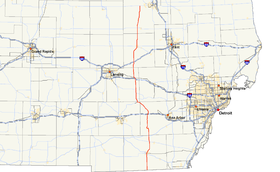
M-52 highlighted in redRoute information Maintained by MDOT Length: 127.300 mi[2] (204.869 km) Existed: ca. July 1, 1919[1] – present Major junctions South end:  SR 109 at Ohio border
 US 223 in Adrian
 US 12 near Clinton
 I-94 in Chelsea
 I-96 in Webberville
 I-69 in Perry
North end:  M-46 near Saginaw
Location Counties: Lenawee, Washtenaw, Jackson, Ingham, Shiawassee, Saginaw Highway system Michigan State Trunkline Highway System
Interstate • US • State←  M-51
M-51M-53  →
→M-52 is a north–south state trunkline highway in the US state of Michigan. The southern terminus is on the Ohio border, where it continues as State Route 109 (SR 109). The highway passes through communities like Adrian, where it intersects US Highway 223 (US 223), Chelsea and Webberville along its 127.300 miles (204.869 km) course. It crosses some major rivers, including the River Raisin and the Shiawassee. The section of the highway between M-50 and Manchester was built as a limited-access highway. M-52's northern terminus is at M-46, 9 miles (14 km) west of Saginaw.
Adrian previously converted their downtown streets to one-way traffic between 1950 and 1973. The traffic pattern created an unusual arrangement in the routings of the two state highways downtown. Southbound M-52 followed Winter Street, which also carried both eastbound and westbound directions of the US 223 business loop. These streets carried both highways around the downtown business district in this arrangement until November 2009.
M-52 is an original state trunkline highway, dating to the 1919 formation of the system. Other segments of the modern routing were designated M-92 and M-47 at the time. Extensions to M-52 supplanted M-92 completely and M-47 partially along their routings. These extensions completed the modern M-52 routing in the late 1960s.
Contents
Route description
M-52 starts at the Ohio state line as Adrian Highway in Fairfield Township, Lenawee County, where it is the continuation of SR 109 into Michigan. The highway runs north to Adrian where it intersects US Highway 223 (US 223) at the city border with Madison Township.[2] As the highway crosses the city line, it is concurrently designated Business US 223 (BUS US 223) along Main Street into downtown Adrian. BUS US 223/M-52 intersects Beecher Street, which carries M-34 to the latter's eastern terminus in Adrian. After Beecher, Main Street turns north-northeast into the downtown area.[3]
In downtown Adrian, M-52 runs north along Main Street to Church Street. Since November 2009, the one-way streets were converted back to two-way functionality. Both directions of M-52 now turn east along Church, then north along Broad Street. At Front Street, traffic is diverted west back to Main Street.[4] Continuing north out of downtown Adrian, M-52 follows Main Street over the South Branch of the River Raisin and out of the city limits, where it once again becomes Adrian Highway. The highway curves from running north-northeast back to due north. West of the city of Tecumseh, the trunkline intersects M-50. M-52 continues north as a limited-access highway. Access to and from the highway is limited to select cross roads only. Just south of the county line, the highway intersects with US 12 before crossing into Washtenaw County.[5]
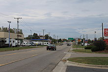 M-52 north of I-94 intersection, Chelsea
The limited-access section of M-52 continues north through western Washtenaw County, where it ends in Manchester.[2] M-52 turns west along Austin and City roads into the village. The trunkline continues along the banks of the north branch of the River Raisin on Riverside Drive before turning north out of town.[6] Just south of Chelsea, M-52 crosses Interstate 94 (I-94). The highway continues through downtown Chelsea and turns northwesterly through the Waterloo State Recreation Area in the northwesternmost part of the county.[7] The highway clips the corner of Jackson County, running for almost 2.5 miles (4.0 km) through Waterloo Township before crossing into Ingham County south of Stockbridge.[2]
M-52 joins M-106 south of Stockbridge, and the two highways run together into the village. In downtown, M-106 turns east and M-52 turns west before heading north out of town. At the Stockbridge – White Oak township line, M-52 joins M-36 which follows the townships' common border. The two highways run concurrently north into White Oak Township before M-36 turns west, ending the concurrency.[2] In western Webberville, M-52 passes under I-96 and merges with M-43 at the latter's eastern terminus. The two highways run north to, and turn west along, Grand River Avenue. At Perry Road, M-52 turns back north out of the village.[8] The trunkline continues north into Shiawassee County and runs through Perry before crossing I-69. Continuing north, M-52 curves northeasterly into downtown Owosso intersecting M-21 west of M-71's western terminus. M-52 continues northward parallel to the Shiawassee River into Saginaw County.[5]
The trunkline runs through the community of Oakley before intersecting M-57 west of Chesaning. North of Chesaning, M-52 angles to the northeast into and through St. Charles,[5] crossing the Shiawassee River west of the Shiawassee National Wildlife Refuge.[9] The northern terminus of M-52 is an intersection with M-46 west of Saginaw in Thomas Township.[2]
History
M-52 was first designated by July 1, 1919. The original routing started at the Ohio state line and ran north through Adrian to M-50 much as it does today. It turned east along M-50 into Tecumseh and then turned north to Clinton where it terminated. The remainder of the modern highway routing is either not part of the state trunkline system, or it is parts of other highways at this time, M-92 or M-47.[1] In 1954, M-92 was extended southward to end in Clinton at the same intersection with US 112 where M-52 terminated.[10][11] By July 1, 1960, M-92's southern end was shifted westward, terminating west of Clinton at US 112 on a new roadway south of Manchester.[12] M-52 was extended around 1962 north between M-50 and US 12 (the former US 112) west of Tecumseh and Clinton. This extension ended at M-92's terminus with US 12. M-52 was then extended north supplanting the M-92 designation in its entirety. M-52 at this time runs north from the Ohio state line to Millville in southwestern Ingham County.[13][14] In the late 1960s, Stockbridge Road between Webberville and Stockbridge was upgraded to state highway standards and uploaded from the county to the state. This construction was shown on the 1969 state map.[15] When it was completed later that year, M-52 was extended northward a second time, to I-96 outside of Webberville. Where Stockbridge Road crossed I-96, M-52 was continued north, supplanting M-47 through Webberville and north to the junction with M-46 west of Saginaw. This designation change shortened M-47 to its current southern terminus in Saginaw Township.[16]
 The previous highway assignments on the one-way streets in Downtown Adrian
In downtown Adrian, the highways previously split into an uncommon arrangement of one-way streets. This arrangement was similar to a traffic circle in how the traffic was routed through the central business district on Church, Broad, Front and Winter streets. The first one-way pairing started on Main Street at the intersection with Winter Street. Northbound traffic continued on Main Street, while southbound traffic was routed along Winter Street. At Church Street, westbound BUS US 223/northbound M-52 turned east for a block on Church and then north onto Broad Street. Then the highway designations continued on Broad Street three blocks north to Front Street, passing to the east of the downtown businesses. The designations were then routed west along Front Street. At Main Street, M-52 turned back north again as a two-way street. In the opposite direction, southbound M-52 traffic was diverted from Main west on Front Street. Front Street west of Main Street carried southbound M-52 and westbound BUS US 223 traffic one block west to Winter Street, which then turned down Winter. Westbound BUS US 223 traffic turned west along Maumee Street while eastbound BUS US 223 followed southbound M-52 down Winter to Main Street.[3][17] This arrangement was ended in November 2009 when the City of Adrian converted all of the one-way streets to two-way traffic. Downtown streets had been converted to one-way traffic between 1950 and 1973.[4]
Major intersections
County Location Mile[2][18] Destinations Notes Lenawee Fairfield Township 0.000 SR 109 southOhio state line Madison Township –
Adrian10.959 US 223 – Jackson, Toledo


BUS US 223 northSouthern end of BUS US 223 concurrency on the Adrian city line Adrian 11.963  M-34 west – Hillsdale
Eastern terminus of M-34 12.501
BUS US 223 northNorthern end of BUS US 223 concurrency Tecumseh Township 21.231  M-50 – Jackson, Monroe
Franklin Township 25.688 US 12 – Ypsilanti, ColdwaterWashtenaw Chelsea 42.429 I-94 – Detroit, ChicagoExit 159 on I-94 Jackson No major junctions Ingham Stockbridge 57.011  M-106 south – Jackson
Southern end of M-106 concurrency 58.829 M-106 north – GregoryNorthern end of M-106 concurrency Stockbridge Township –
White Oak Township62.327  M-36 east – Gregory
Southern end of M-36 concurrency White Oak Township 65.097 M-36 west – MasonNorthern end of M-36 concurrency Webberville 72.350 I-96 – Lansing, Detroit
 M-43 west
Exit 122 on I-96; southern end of M-43 concurrency; eastern terminus of M-43 Leroy Township 74.180 M-43 west – LansingNorthern end of M-43 concurrency Shiawassee Perry 85.844 I-69 – Lansing, FlintExit 105 on I-69 Owosso 97.606  M-21 – St. Johns, Flint
Saginaw Brady Township –
Chesaning Township110.815  M-57 – Greenville, Clio
Thomas Township 127.300 M-46 – Alma, Saginaw1.000 mi = 1.609 km; 1.000 km = 0.621 mi
Concurrency terminus • Closed/Former • Incomplete access • UnopenedReferences
- ^ a b Michigan State Highway Department (1919). State of Michigan: Lower Peninsula (Map). Cartography by MSHD.
- ^ a b c d e f g Michigan Department of Transportation (2009). Control Section/Physical Reference Atlas (Map). http://mdotwas1.mdot.state.mi.us/public/maps/pr/. Retrieved July 26, 2009.
- ^ a b Google, Inc. Google Maps – Adrian, Michigan (Map). Cartography by Google, Inc. http://maps.google.com/maps?f=q&source=s_q&hl=en&geocode=&q=adrian,+mi&sll=37.0625,-95.677068&sspn=64.497063,65.654297&ie=UTF8&hq=&hnear=Adrian,+Lenawee,+Michigan&ll=41.899402,-84.039831&spn=0.060436,0.064116&z=14. Retrieved February 22, 2010.
- ^ a b Wheaton, Bob (November 17, 2009). "No major problems with two-way traffic switch". The Daily Telegram (Adrian, MI). http://www.lenconnect.com/news/x255188161/No-major-problems-with-two-way-traffic-switch. Retrieved March 15, 2010.
- ^ a b c Michigan Department of Transportation (2009). Official Department of Transportation Map (Map). 1 in.:15 mi/1 cm:9 km. Section J11–N12.
- ^ Google, Inc. Google Maps – Manchester, Michigan (Map). Cartography by Google, Inc. http://maps.google.com/maps?f=q&source=s_q&hl=en&geocode=&q=Manchester,+MI&sll=37.0625,-95.677068&sspn=64.497063,65.654297&ie=UTF8&hq=&hnear=Manchester,+Washtenaw,+Michigan&ll=42.153255,-84.030862&spn=0.030097,0.032058&z=15. Retrieved February 22, 2010.
- ^ Google, Inc. Google Maps – Chelsea, Michigan (Map). Cartography by Google, Inc. http://maps.google.com/maps?f=q&source=s_q&hl=en&q=Chelsea,+Washtenaw,+Michigan&sll=37.0625,-95.677068&sspn=64.497063,65.654297&ie=UTF8&cd=1&geocode=FQy5hQId6fL9-g&split=0&hq=&hnear=Chelsea,+Washtenaw,+Michigan&ll=42.331012,-84.020691&spn=0.120051,0.128231&z=13. Retrieved February 22, 2010.
- ^ Google, Inc. Google Maps – Webberville, Michigan (Map). Cartography by Google, Inc. http://maps.google.com/maps?f=q&source=s_q&hl=en&geocode=&q=Webberville,+Michigan&sll=37.0625,-95.677068&sspn=64.497063,65.654297&ie=UTF8&hq=&hnear=Webberville,+Ingham,+Michigan&z=14. Retrieved February 22, 2010.
- ^ "Directions to Shiawassee National Wildlife Refuge". US Fish & Wildlife Service. November 20, 2009. http://www.fws.gov/midwest/Shiawassee/Directions.htm. Retrieved February 22, 2010.
- ^ Michigan State Highway Department (April 15, 1954). 1954 Official Highway Map (Map). Section N12.
- ^ Michigan State Highway Department (October 1, 1954). 1954 Official Highway Map (Map). Section N12.
- ^ Michigan State Highway Department (1960). Official Highway Map (Map). (Includes all changes through July 1, 1960)
- ^ Michigan State Highway Department (1962). Official Highway Map (Map). Section N12.
- ^ Michigan State Highway Department (1963). Official Highway Map (Map). Section N12.
- ^ Michigan Department of State Highways (1969). Official Highway Map (Map). 1 in.:14.5 mi.. Cartography by H.M. Gousha. Section M11.
- ^ Michigan Department of State Highways (1970). Official Highway Map (Map). 1 in.:14.5 mi.. Section K11–L11.
- ^ Michigan Department of Transportation (2009). Official Department of Transportation Map (Map). Adrian inset. http://www.michigan.gov/documents/MDOT-State-Map-Adrian_64162_7.pdf. Retrieved February 22, 2010.
- ^ "MDOT Physical Reference Finder Application". Michigan Department of Transportation. 2009. http://www.mcgi.state.mi.us/prfinder/. Retrieved April 9, 2010.
External links
Categories:- State highways in Michigan
- Central Michigan
- Two-lane freeways in the United States
- Grand River Avenue


Wikimedia Foundation. 2010.