- Pictured Rocks National Lakeshore
-
Pictured Rocks National Lakeshore IUCN Category III (Natural Monument)

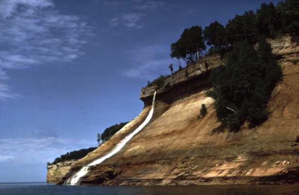
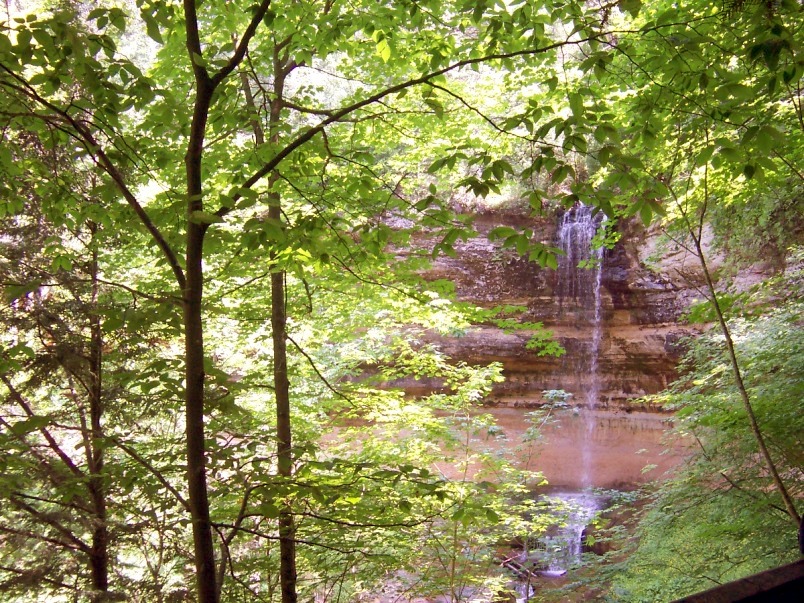
Location Alger County, Michigan, USA Nearest city Munising, Michigan Coordinates 46°33′44″N 86°18′45″W / 46.56222°N 86.3125°WCoordinates: 46°33′44″N 86°18′45″W / 46.56222°N 86.3125°W Area 73,236 acres (296.4 km2) Established October 15, 1966 Visitors 476,888 (in 2005) Governing body National Park Service Michigan State Historic SiteOfficial name: Pictured Rocks Designated: February 17, 1965  Bridalveil Falls emptying into Lake Superior
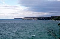
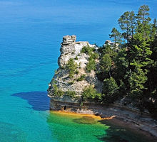 Miners' Castle
Pictured Rocks National Lakeshore is a U.S. National Lakeshore on the shore of Lake Superior in the Upper Peninsula of Michigan, United States. It extends for 42 miles (67 km) along the shore and covers 73,236 acres (114 sq mi; 296 km2). The park offers spectacular scenery of the hilly shoreline between Munising, Michigan and Grand Marais, Michigan, with various rock formations like natural archways, waterfalls, and sand dunes.
Pictured Rocks derives its name from the 15 miles (24 km) of colorful sandstone cliffs northeast of Munising. The cliffs are up to 200 feet (60 m) above lake level. They have been naturally sculptured into shallow caves, arches, formations that resemble castle turrets, and human profiles, among others. Near Munising visitors also can view Grand Island, most of which is included in the Grand Island National Recreation Area and is preserved separately.
The U.S. Congress made Pictured Rocks the first officially-designated National Lakeshore in the United States in 1966. It is governed by the National Park Service (NPS), had 22 year-round NPS employees as of May 2006, and received 476,888 visitors in 2005.
Contents
Geology and history
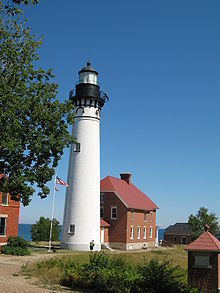 Au Sable Light, built in 1874 after numerous shipwrecks
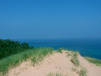 Grand Sable Dunes
The colors in the cliffs are created by the large amounts of minerals in the rock. The cliffs are composed of the Munising Formation of 500 million year old Cambrian period sandstone. The Munising Formation sits atop a Precambrian sandstone of the Jacobsville Formation. The mottled red Jacobsville Formation is the oldest rock in the park. On top of the Munising Formation is the younger Au Train Formation from the Ordovician period. The Au Train Formation is a hard sandstone and acts as a "cap" over the other layers. Streaks on the face of the cliffs come from the groundwater leaching out of the rock. With it come iron (red), manganese (black-white), limonite (yellow-brown), copper (pink-green) and other minerals. As the water evaporates, these minerals leave streaks of color.[1]
Although the Pictured Rocks lie adjacent to sections of Lake Superior that are rich in fish, the sandstone cliffs are dangerous to canoes and other open boats skirting the coastline. Pierre Esprit Radisson, the fur trader, made this risky passage in 1658 and noted that his Native American companions offered some tobacco to the local spirit of the cliffs.
During the Romantic Era of the 1800s, a series of American writers described their feelings upon sight of the Pictured Rocks. Henry Rowe Schoolcraft visited in 1820 and remarked upon "some of the most sublime and commanding views in nature".[2] As long ago as 1850 developers planned a tourist resort, Grand Island City, adjacent to the Pictured Rocks near the current site of Munising.
After the lumbering era ended around 1910, many of the parcels of land making up the current Pictured Rocks National Lakeshore reverted to the state of Michigan for unpaid property taxes. Eager for federal help and recognition, the state cooperated with the federal government in the region's redevelopment. Congress enacted a law in 1966 to elevate the shoreline between Munising and Grand Marais to the status of a National Lakeshore.[3]
In October 1966, Congress passed a bill authorizing the establishment of the Pictured Rocks National Lakeshore in Michigan's Upper Peninsula, “in order to preserve for the benefit, inspiration, education, recreational use, and enjoyment of the public, a significant portion of the diminishing shoreline of the United States and its related geographic and scientific features.” When President Lyndon Johnson signed the bill, Alger County became the home of America’s first National Lakeshore.
On March 30, 2009, the Omnibus Public Land Management Act was signed into law, protecting 11,740 acres (47.5 km2) of Pictured Rocks as the Beaver Basin Wilderness.[4]
Access and accessibility
Munising, on the western end of the lakeshore, is accessed by M-28 and M-94. Grand Marais, on the eastern end, is reached by M-77.
Paved highways penetrate part way into the lakeshore from both ends. Travelers seeking to drive from one end of the lakeshore to the other must use County Road H-58. Roads only come close to the shoreline near Miners Castle, 12 Mile Beach, and the Grand Sable Dunes. The rest of the shoreline is only seen from land by hiking.
A 42-mile (67-km) section of the North Country Trail spans the lakeshore.
Pictured Rocks Cruises[5] offers daily trips from Memorial Day weekend through October 10. Sea kayaking is a popular method of exploring the park. While this may be the best way to see the natural formations, it is a serious trip in dangerous and cold water, which should not be undertaken lightly or without proper equipment. Guides are available. The most efficient port of entry to Pictured Rocks, for a sea kayak, is from the harbor at Munising.[6]
Camping must be done only in designated areas, and is strictly regulated by the National Park rangers.
Winter sports activities include cross-country skiing, snowshoeing, snowmobiling, and ice fishing.
Pictured Rocks has worked to make much of its rugged environment accessible,[7] including the following:
- Interagency Visitor Center, Munising Falls Interpretive Center, and Miners Castle Information Station in Munising
- Grand Sable Visitor Center in Grand Marais
- Each drive-in campground has at least one handicapped accessible campsite with an extended picnic table, boardwalk, pedestal fire grate, and nearby rest room.
- Log Slide overlook
- All Miners Castle overlooks (however, the lower overlook trail includes stairs and is steep)
- Munising Falls viewing platform trail is paved.
- Boardwalk at the Sand Point Marsh Trail. A large-print guide is available.
- Sand Point beach parking and sidewalks are paved. There is a fully accessible picnic site. The boardwalk enables visitors to go part of the way to Lake Superior.[7]
Points of interest
From west (Munising) to east (Grand Marais):
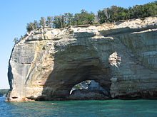 Rock arches and sea caves are popular with kayakers
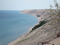 Grand Sable Dunes
- Munising Falls and Interpretive Center
- Sand Point: National Lakeshore Headquarters
- Miners Castle: Rock formation, paved road to overlook
- Significantly altered by a major rockfall on April 13, 2006
- Miners River, including Miners Lake and Miners Falls. Empties into Lake Superior near Miners Beach.
- Miners Falls, interpretive trail
- Grand Portal Point: rock formations
- Mosquito Falls
- Mosquito River
- Chapel Rock
- Chapel Falls
- Beaver Basin Wilderness
- Twelvemile Beach
- Shipwrecks
- White Birch Forest
- Au Sable Point: Au Sable Light
- Log Slide
- Grand Sable Dunes
- Grand Sable Lake
- Sable Falls and Interpretive Center
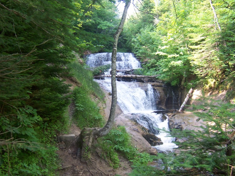
Waterfalls
Pictured Rock is the home of many of Michigan's waterfalls. Most of the waterfalls resulted from water running over cliffs of the Munising Formation. This lime and sandstone formation exists between Tahquamenon Falls, some 75 miles (121 km) east, to Laughing Whitefish Falls, 30 miles (48 km) miles west of the Lakeshore. Pets are not allowed on most of the trails.[8]
- Munising Falls—A 50 feet (15 m) waterfall over a sandstone cliff. Along the trail may be seen ferns, wildflowers, and an occasional mink. The trail is fully accessible.[9]
- Miners Falls—This self-guiding interpretive trail passes Miners Basin and ends at Miners Falls. There are 77 steps leading down to the viewing platform. The falls drops 50 feet (15 m) over the sandstone outcrop.[9]
- Bridalveil Falls—Bridalveil is a seasonal waterfall. In the summer, it may not exist or be only a trickle.[9]
- Mosquito Falls—This falls drops over an 8 feet (2.4 m) rock shelf on the Mosquito River. River otters and beavers live in the stream along the trail.[9]
- Chapel Falls—Two viewing platforms along the way provide views of the scenic Chapel Basin. Chapel Falls cascades some 60 feet (18 m) down the sandstone cliffs on its way to Chapel Lake.[9]
- Spray Falls—This waterfall is best seen from Lake Superior. The 1856 shipwreck of the Superior is at the base of the falls in 20 feet (6.1 m) of water.[9]
- Sable Falls - Sable Falls tumbles 75 feet (23 m) over several cliffs of Munising and Jacobsville sandstone formations on its way to Lake Superior.[9]
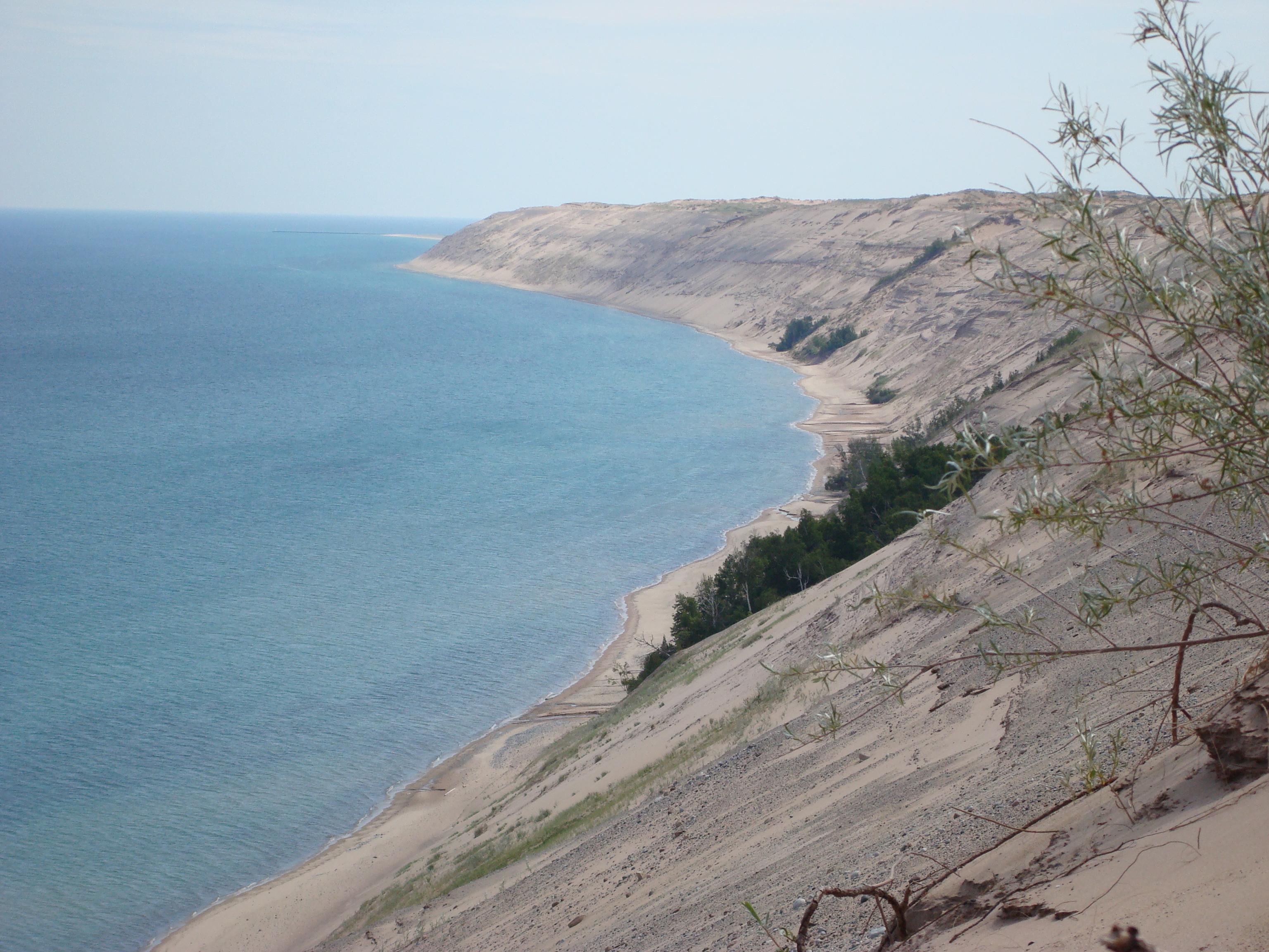
Grand Sable Dunes
The Grand Sable Dunes, at the eastern end of the Lakeshore, are a perched dune formation. Sand washed ashore by wave action was then blown upslope by northerly prevailing winds until it came to rest atop a glacial moraine. The Grand Sable Dunes today form a sand slope that rises from Lake Superior at a 35° angle. The summits of the tallest dunes are as high as 275 feet (85 m) above lake level.
Climate and weather
Climate data for Grand Marais, Michigan Month Jan Feb Mar Apr May Jun Jul Aug Sep Oct Nov Dec Year Average high °F 25.3 27.4 36.4 49.2 62.1 70.4 75.9 74.8 67 55.8 41.5 29.7 51.3 Average low °F 11.2 10.6 17.9 29.3 37.9 45.7 51.9 52.8 47.1 38 28.2 17 32.3 Rainfall inches 2.3 1.4 1.6 1.6 2.5 2.9 2.5 3.2 3.6 3 2.6 2.5 29.8 Snowfall inches 47.3 30.7 16 4.8 0.3 0.0 0.0 0.0 0.0 0.9 12.6 41.7 154.2 Average high °C −3.7 −2.6 2.4 9.6 16.7 21.3 24.4 23.8 19 13.2 5.3 −1.3 {{{year high C}}} Average low °C −11.6 −11.9 −7.8 −1.5 3.3 7.6 11.1 11.6 8.4 3 −2.1 −8 {{{year low C}}} Rainfall mm 58 36 41 41 64 74 64 81 91 76 66 64 757 Snowfall cm 120.1 78 41 12.2 0.8 0 0 0 0 2.3 32 105.9 391.7 Source: [10] References
- ^ Pictured Rocks National Lakeshore, Michigan; Park brochure, Harpers Ferry, West Virginia; 2002
- ^ Schoolcraft, Henry R. (1821). Narrative Journal of Travels through the Northwestern Regions of the United States, p. 150. E. & E. Hosford.
- ^ The Pictured Rocks: An Administrative History of Pictured Rocks National Lakeshore (Table of Contents)
- ^ National Park Service: Beaver Basin Wilderness. Accessed 9-28-2011.
- ^ Pictured Rocks Cruises Inc. Boat Tours
- ^ National Park Service on visiting Pictured Rocks
- ^ a b Pictured Rocks Accessibility
- ^ Waterfalls
- ^ a b c d e f g Waterfalls site bulletin, Pictured Rocks NL, Munising, Michigan
- ^ "Weatherbase: Historical Weather for Grand Marais, Michigan". http://www.weatherbase.com/weather/weather.php3?s=913302&refer==. Retrieved June 5, 2009.
Further reading
- Stonehouse, Frederick. Dangerous Coast: Shipwrecks of Pictured Rocks, Avery Color Studios, June 1997. ISBN 093221293X.
External links
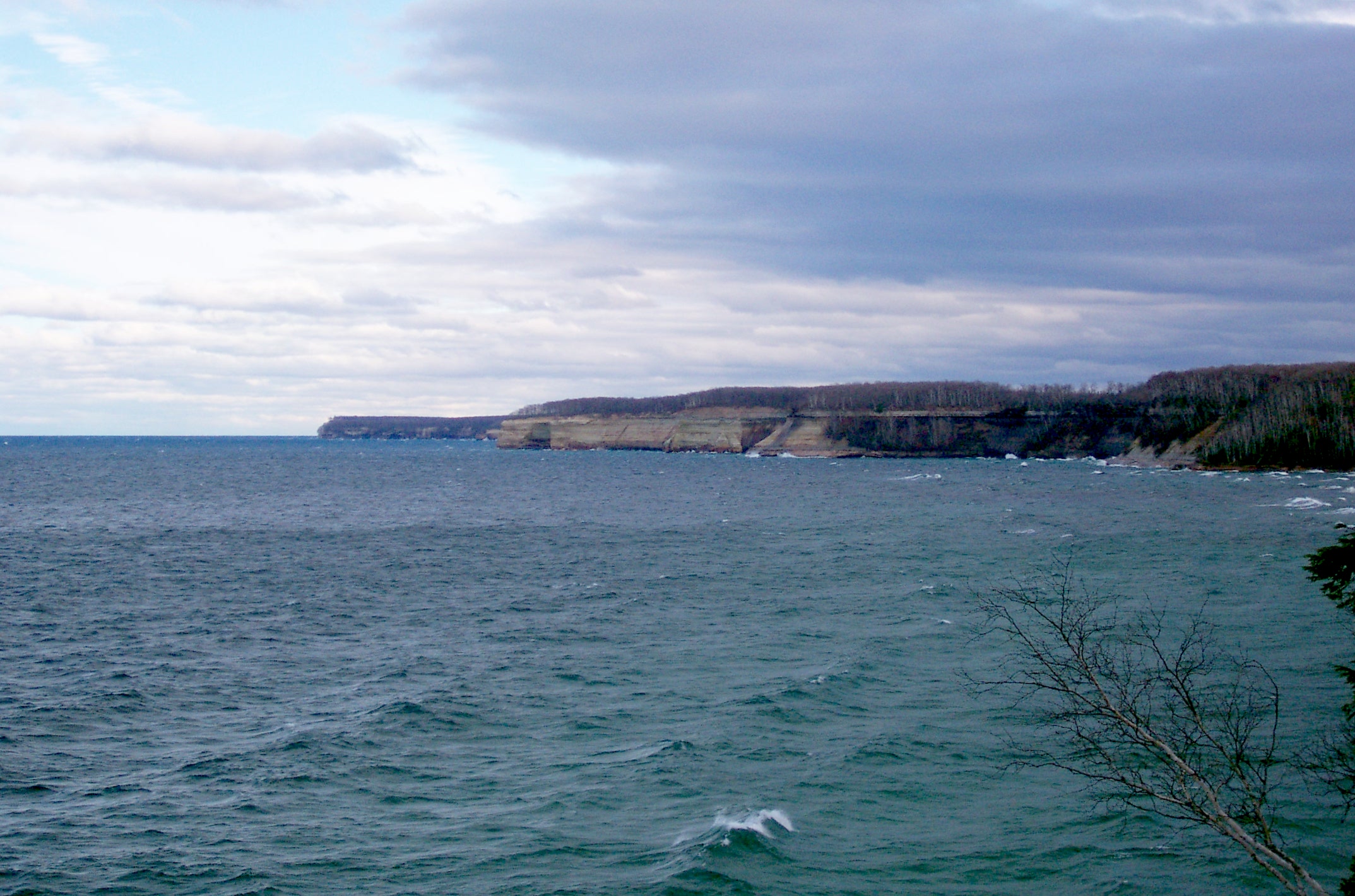
 Pictured Rocks in the distance.
Great Lakes of North America Main lakes 
Secondary lakes Waterways Detroit River • Erie Canal • French River • Great Lakes Waterway • Niagara River • Nipigon River • St. Clair River • Saint Lawrence River • Saint Lawrence Seaway • St. Marys River • Soo Locks • Straits of Mackinac • Trent–Severn Waterway • Welland CanalLists of islands Historic geology Lakeshores Apostle Islands National Lakeshore • Calumet Shoreline • Glenwood Shoreline • Indiana Dunes National Lakeshore • Pictured Rocks National Lakeshore • Sleeping Bear Dunes National LakeshoreRelated topics Basin • Bays of the Great Lakes • Great Lakes region • Georgian Bay • Great Lake ships • Isle Royale • Lake effect • Manitoulin Island • Megalopolis • Quebec City – Windsor Corridor • Settlements • Shipwrecks • Tall shipsProtected Areas of Michigan See also: Important Bird Areas of MichiganFederal National Parks:River Raisin National Battlefield ParkNational Lakeshores:Pictured Rocks National Lakeshore · Sleeping Bear Dunes National LakeshoreBlack Spruce Bog Natural Area · Dead Stream Swamp · Dukes Research Natural Area · Grand Mere Lakes ·
Haven Hill State Natural Area · Newton Woods · Porcupine Mountains · Roscommon Virgin Pine Stand · Strangmoor Bog · Tobico Marsh · Toumey Woods · Warren Woods State ParkDetroit River International Wildlife Refuge · Harbor Island · Huron · Kirtlands Warbler Wildlife Management Area · Michigan Islands · Michigan Wetland Management District · Seney · Shiawassee ·
State Algonac · Aloha · Baraga · Bewabic · Brimley · Burt Lake · Cambridge Junction · Cheboygan · Clear Lake · Coldwater Lake · Craig Lake · Dodge #4 · Duck Lake · Fayette · Fisherman's Island · Fort Michilimackinac · Fort Wilkins · Grand Haven · Grand Mere · Harrisville · Hart-Montague Trail · Hartwick Pines · Hayes · Mill Creek · P.H. Hoeft · P.J. Hoffmaster · Holland · Indian Lake · Interlochen · Kal-Haven Trail · Lake Gogebic · Lakelands Trail State Park · Lakeport · Leelanau · Ludington · Mackinac Island · Maybury · F.J. McLain · Mears · Meridian-Baseline · Mitchell State Park · Muskallonge Lake · Muskegon · Negwegon · Newaygo · North Higgins Lake · Onaway · Orchard Beach · Otsego Lake · Palms Book · Petoskey · Porcupine Mountains · Port Crescent · Sanilac Petroglyphs · Saugatuck Dunes · Seven Lakes · Silver Lake · Sleeper · Sleepy Hollow · South Higgins Lake · Sterling · Straits · Tahquamenon Falls · Tawas Point · Thompson's Harbor · Traverse City · Twin Lakes · Van Buren · Van Buren Trail · Van Riper · Warren Dunes · Warren Woods · Wells · White Pine Trail · Wilderness · William G. Milliken · Wilson · Young
State Recreation
AreasBald Mountain · Bass River · Bay City · Brighton · Fort Custer · Highland · Holly · Ionia · Island Lake · Lake Hudson · Metamora-Hadley · Ortonville · Pinckney · Pontiac Lake · Proud Lake · Rifle River · Waterloo · Wetzel · Yankee Springs
Alger Underwater Preserve · De Tour Passage Underwater Preserve · Grand Traverse Bay Bottomland Preserve · Keweenau Underwater Preserve · Manitou Passage Underwater Preserve · Marquette Underwater Preserve · Sanilac Shores Underwater Preserve · Southwest Michigan Underwater Preserve · Straits of Mackinac Shipwreck Preserve · Thumb Area Bottomland Preserve · Thunder Bay National Marine Sanctuary · Whitefish Point Underwater Preserve ·
Other
(inc. state game areas)Agate Falls Scenic Site · Bond Falls Scenic Site · Laughing Whitefish Falls Scenic Site · Michigan Islands Wilderness Area · Pointe Mouillee State Game Area · Ralph A. MacMullan Conference Center · Sturgeon Point Scenic Site · Wagner Falls Scenic Site
Categories:- IUCN Category III
- Protected areas of Alger County, Michigan
- Dunes of the United States
- Landmarks in Michigan
- Tourism in Michigan
- Upper Peninsula of Michigan
- Protected areas established in 1966
- Cliffs of the United States
- Landforms of Michigan
- United States National Park Service areas in Michigan
- Pictured Rocks National Lakeshore


Wikimedia Foundation. 2010.