- Arequipa Region
-
This article is about the Arequipa Region. For its capital city, see Arequipa.
Arequipa Region — Region — Location of the Arequipa Region in Peru
Country Peru Subdivisions 8 provinces and 109 districts Capital Arequipa Government – President Juan Manuel Guillén Benavides Area – Total 63,345.39 km2 (24,457.8 sq mi) Highest elevation 6,305 m (20,686 ft) Lowest elevation 0 m (0 ft) Population (2010 est.) – Total 1,218,168 – Density 19.2/km2 (49.8/sq mi) UBIGEO 04 Dialing code 054 ISO 3166 code PE-ARE Principal resources Wheat, cotton, rice, onion,
garlic, cooper seed fruits,
milk.Poverty rate 21.0% (INEI) Percentage of Peru's GDP 5.64% Website www.regionarequipa.gob.pe Arequipa is a region in southwestern Peru. It is bordered by the Ica, Ayacucho, Apurímac and Cusco regions on the north; the Puno Region on the east; the Moquegua Region on the south; and the Pacific Ocean on the west. Its capital, also called Arequipa, is Peru's second-largest city.
Contents
Geography
This region has a rough topography which is characterized by heavy layers of volcanic lava covering large areas of its inter-Andean sector. It has deep canyons such as the ones formed by the Ocoña and Majes rivers. Plateaus range in height from medium, such as La Joya, and high-altitude ones such the Arrieros Pampa and those located in the zones of Chivay, Huambo and Pichucolla. Volcanic cones are seen emerging above the plateaus and forming snowfalls, such as Misti, Chachani, Ampato, Mismi, Solimana and Coropuna. In contrast with these heights, there are deep canyons, including Majes, Colca, Sihuas and Ocoña, where important aspects of the ecological evolution of this zone can be clearly observed.
In the Coast, small plateaus and dunes represent characteristics of the desert of Arequipa, such as the ones located in the Majes, Sihuas and La Joya pampas, which are particularly beautiful and developed.
From a hydrographic point of view, the rivers draining its territory belong mainly to the Pacific watershed. Some rivers belong to the Amazon hydrographic system. Some of the region's main rivers are: Ocoña, Yauca, Camana and Quilca. The starting point of the Amazon River, the longest river on Earth, is located in the Arequipa region.
Points of interest
There are numerous points of interest in the Arequipa region. The three coastal provinces, Caraveli, Camana and Islay all have popular beaches. Various ports can also be found along the coastline, the two most important being Mollendo and Matarani, both in the province of Islay.
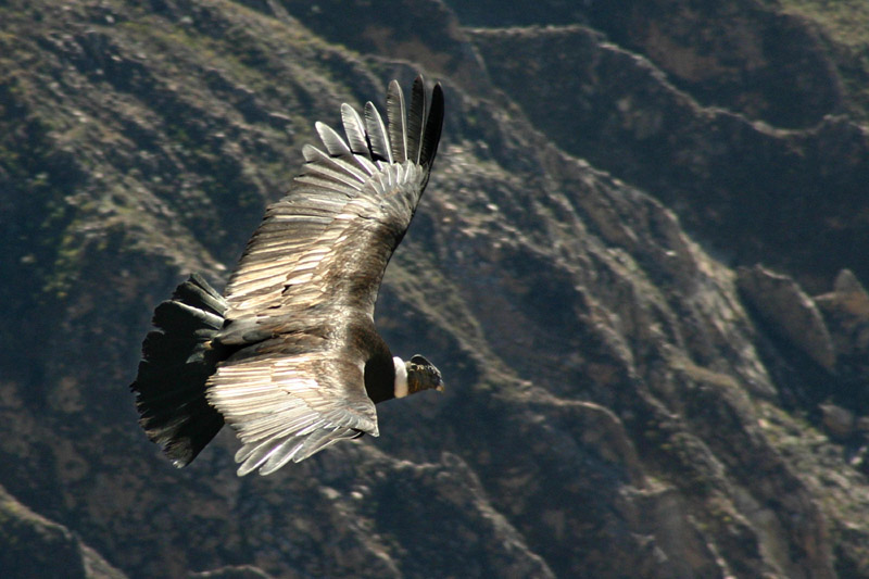
The Colca Canyon, twice as deep as the Grand Canyon in the United States, is in the province of Caylloma. The Cotahuasi Canyon is in the province of La Union. Colca Valley provides incredible close-up views of majestic Andean condors soaring in their natural habitat. Cotahuasi, at 3535 meters, is presently thought to be the deepest canyon in the world. Both canyons offer spectacular scenery and villages as yet unaffected by the modern world.
In the province of Castilla, by the town of Corire, is Toro Muerto where one can see more than 3,000 petroglyphs. Further to the north, near the town of Andaguas, lies the Valley of Volcanoes. Almost 100 cones of various sizes dominate the lava-hardened landscape.
Political division
 An Andean condor soars over the Colca Canyon.
 Provinces of the Arequipa region
The region is divided into eight provinces (provincias, singular: provincia), which are composed of 109 districts (distritos, singular: distrito). The provinces, with their capitals in parentheses, are:
- Arequipa (Arequipa)
- Camaná (Camaná)
- Caravelí (Caravelí)
- Castilla (Aplao)
- Caylloma (Chivay)
- Condesuyos (Chuquibamba)
- Islay (Mollendo)
- La Unión (Cotahuasi)
See also
External links
 Regions of Peru
Amazonas · Ancash · Apurímac · Arequipa · Ayacucho · Cajamarca · Callao · Cusco · Huancavelica · Huánuco · Ica · Junín · La Libertad · Lambayeque · Lima · Loreto · Madre de Dios · Moquegua · Pasco · Piura · Puno · San Martín · Tacna · Tumbes · Ucayali
Peru's Lima Province is not part of any region.Categories:


Wikimedia Foundation. 2010.