- Ciudad Bolívar
-
Ciudad Bolívar Ciudad Bolívar historical zone

Flag
SealNickname(s): La puerta del sur de Venezuela
(English:"The gate to southern Venezuela")Motto: No encontrarás otra de más variada riqueza
(English:"You won't find another with such a variety of wealth")Heres Municipality in Bolívar State
Coordinates: 8°07′19″N 63°33′00″W / 8.122°N 63.55°WCoordinates: 8°07′19″N 63°33′00″W / 8.122°N 63.55°W Country  Venezuela
State Bolívar Municipality Heres Founded 1764 Government - Mayor Victor Fuenmayor Area - Total 591 km2 (228.2 sq mi) Elevation 43 m (141 ft) Population (2010) - Total 350,691 - Density 593.39/km2 (1,536.9/sq mi) - Demonym Bolívarense Time zone VST (UTC-4:30) - Summer (DST) not observed (UTC-4:30) Postal code 8001 Area code(s) 0285 Website Ciudad Bolívar Online (Spanish) The area and population figures are for the municipality Ciudad Bolívar (Spanish pronunciation: [sjuˈðað βoˈliβar]) (English: Bolivar City) is the capital of Venezuela's southeastern Bolivar State. It was founded with the name Angostura in 1764, renamed in 1846, and, as of 2010, had an estimated population of 350,691.
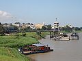
The town lies at a narrowing of the Orinoco River and the original name was a contraction of the town's full descriptive name, Santo Tomé de Guayana de Angostura del Orinoco ("Saint Thomas of Guiana of the narrows of the Orinoco"). The city lies at a spot where the Orinoco narrows to about 1 mile (1.6 km) in width, and is the site of the first bridge across the river. Another bridge has recently been constructed downstream at Puerto Ordaz.
Ciudad Bolivar's historic centre is in a good state of preservation, with original colonial buildings around the Plaza Bolívar, including a cathedral. It today serves as an important port on the Orinoco River for the eastern regions of Venezuela. One of the Orinoco Basin's chief commercial centers, its main products include gold, iron ore, cattle, hides and rare woods. The town also gave its name to the Angostura tree (Cusparia febrifuga) which grows in the area. The bark of the small shrub-like tree was traditionally used as a bitter tonic and fever reducer. Angostura bitters were invented there, though the company which produced them has since moved to Trinidad and Tobago.
In 1973 a Museum of Modern Art opened. It was designed by Carlos Raúl Villanueva and was named after the city's famous son, the kinetic sculptor Jesús Rafael Soto.
Contents
History
 Sketch of Ciudad Bolívar, 1867
 Ciudad Bolívar city hall
Ciudad Bolívar was originally founded as Santo Tomé de Guayana by Antonio Berrío around 1595, at a different site from that which it occupies today. The city underwent changes throughout its history until 1764, when the city transferred to the narrowest part of the Orinoco, assuming the name of Santo Tomé de la Guayana de la Angostura del Orinoco. This move was undertaken with the aid of the Crown of Spain which financed the construction of the church and government buildings. The city received its Coat of arms in 1795, from King Carlos IV, with the inscription No encontrarás otra de más variada riqueza. In the period leading up to 1795 the town suffered attacks by pirates in search of El Dorado due to its river-accessible location,.
In 1800, the town was visited by Alexander Humboldt, who described it as a calm city bordered by a mighty river, and one of the richest places that he had visited in the country, regarding natural resources. The narrowing of the Orinoco at this point increased its strategic importance, making it one of the key sites in the struggle for independence. On April 19, 1810, against the opposition to the Supreme Assembly of Caracas, the authority of Angostura depended upon the outcome of a Provisional Committee, an event much influenced by Bishop José Ventura Cabello. Due to its geographic location the town represented a site which was difficult to conquer in the fight for independence. In 1817 after many attempts and battles, troops under the command of Simón Bolivar and Manuel Piar, managed to overcome the Spanish troops, installing the Supreme Headquarters of the Republic, on October 15, 1817, and incorporating the province of Guayana into Venezuela. On the following day, Piar was executed in the Plaza Mayor of the city, by order of a court martial.
On November 20, 1818, Bolivar presided a great civic-military assembly at which the declaration of the Republic of Venezuela was approved, against the possible intervention of the powers of the Holy Alliance, which backed Spain. The city served as the headquarters for the national revolutionary government, fighting its War of Independence against imperial Spain. On February 15, 1819, the Congress of Angostura declared Simón Bolívar, the South American military leader and revolutionary, the President of Venezuela, and on December 17, 1819, declared the creation of the Republic of Gran Colombia, with Bolívar as president. Bolivar's famous address to the congress (see link), distinguished the Venezuelan character from the North American one, with its "weak and complicated system" of government, and emphasizing the Venezuelan revolutionaries' extraordinary and complicated position ("We are not Europeans; we are not Indians"), and advocated a parliamentary system based on the British model, with a hereditary senate. In 1846, the Congress of the Republic decreed that the city of Angostura, Capital of the Province of Guayana, would henceforth be called Ciudad Bolívar in honor of Simón Bolívar.[1]
Law and government
 Ciudad Bolívar Cathedral and Paseo Orinoco at night
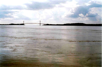
 Angostura Bridge over the Orinoco river at Ciudad Bolívar
 La Piedra del Medio, denominated by Alexander Humboldt like the Orinocometer
Ciudad Bolívar has one municipality: Heres Municipality, Venezuelan law specifies that municipal governments have four main functions: executive, legislative, comptroller, and planning. The executive function is managed by the mayor, who is in charge of representing the municipality's administration. The legislative branch is represented by the Municipal Council, composed of seven councillors, charged with the deliberation of new decrees and local laws. The comptroller tasks are managed by the municipal comptroller's office, which oversees accountancy. Finally, planning is represented by the Local Public Planning Council, which manages development projects for the municipality.[2]
Geography
Ciudad Bolívar is located 43 meters above sea level on the south shore of the Orinoco river at its narrower part, fluvial port of the east of Venezuela. Its northern limit is the Orinoco river, in the south it borders Raul Leoní municipality, to the east the municipalities Caroní and Piar, and to the west Sucre municipality. Ciudad Bolívar is constituted by the parishes Catedral, Agua Salada, Sabanita, Vista Hermosa, Marhuanta, José Antonio Páez, Orinoco, Panapana, and Zea. Geologically, the city presents a great tectonic stability, because the ancient lands, which have survived a series of collapses, also present forms of level earth relief.[3]
Vegetation
The morichales are found at the shores of the rivers, the chaparral. Species including the carob tree, the sarrapia, and the merecure are prevalent, whereas the fauna is represented by such species as capibara, morrocoy, herons, parrots, lapa, iguanas, and others. A high percentage corresponds to fluvial species, like the fishes: curbinata, dorado, lau- lau, morocoto, palometa, sapoara.
Climate
The temperature average varies between 26 and 30 °C. This climatic variety is represented by the periods of rain and drought, presented in high and variable forms, greater rainfall in regard to the high temperatures that cause a strong evaporation, arriving at 1022 mm annual. These high amounts favor the presence of rivers of great volume like the Orinoco, as well as others of minor volume: Orocopiche, Marcela, and La Candelaria, for example.
Month Jan Feb Mar Apr May Jun Jul Aug Sep Oct Nov Dec Year Avg high °F 87 89 91 92 91 88 88 89 89 90 89 87 89 Avg low °F 74 75 77 78 78 77 77 77 78 78 77 76 77 Avg high °C 30 31 32 33 32 31 31 31 31 32 31 30 31 Avg low °C 23 23 25 25 25 25 25 25 25 25 25 24 25 Source: Weatherbase Economy and services
Bolívar state is a region dominated by agriculture and animal husbandry on a small scale. Maize, cassava, mango, yam, and watermelon are characteristic products cultivated in the zone. Cattle activity is represented by the bovine and pig. The fluvial fishing is carried out in a small proportion, the tourism has been receiving economic importance, which comes to reinforce the productive sector of the city. Among others economic activities of the city are, the commerce, services, transports, fast food chains like McDonalds, and distributors of national and international industries, such as: Plumrose, Pepsi-Cola, Coca-Cola, Empresas Polar, Bloque de Armas, as well as the Supermarket chains, Central Madeirense, Koma, among others. Ciudad Bolívar is the seat of the government of Bolívar state.
 Paseo Orinoco, part of the shopping district of the city
The Angostura Bridge has great importance as a communicational infrastructure, since it unites this locality with the rest of Venezuela. Also important is the freeway that connects Ciudad Bolívar with Ciudad Guayana. Another representative infrastructure is the General José Tomás de Heres airport. The city hosts hotels such as Laja Real, La Cumbre, El Bolívar Gran Hotel, Salto Ángel, Posada Amor Patrio, Posada Angostura, and others. The hospital infrastructure is represented among others by: Thorax Hospital, Ruiz y Páez Hospital, Red Cross.
Centers of education include the universities Universidad Nacional Experimental Simón Rodríguez, Universidad de Oriente, Universidad Gran Mariscal de Ayacucho, Universidad Nacional Abierta, etc., and institutes of primary and secondary education. Nevertheless, Ciudad Bolívar lacks the required infrastructure to obtain true economic and social progress, because the competent organizations have not developed a work plan that really responds to the exigency of the city, as capital and seat of the political power of the Bolívar state. Among the services of the locality are drinking water, electricity, telephone, transport, mail, Internet, banks, and malls, among others, that influence the profit of the economic development, and the well-being of the population. The communications are represented by the roads and the media, that facilitate commerce and the relations between the people. Examples of these mass media are television (Bolivar Visión, TV Río), radio, Internet, and newspapers (El Bolivarense, El Expreso, El Progreso, El Luchador), among others. The most important routes of transport are terrestrial, as much extraurban and interurban, covering national routes, and the fluvial, represented mainly by boats that cover the passage from Ciudad Bolívar to Soledad, as well as other small towns.[4]
Culture
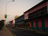
 A street in the historical zone of Ciudad Bolívar
Ciudad Bolívar's historical zone is a frequently visited tourist attraction, featuring houses and buildings that date from the colonial period. The Jesús Soto Museum of Modern Art, named after the city's most famous son, sculptor and painter Jesús Rafael Soto, features a collection of modern works by Venezuelan and international artists. Ciudad Bolívar is also the birthplace of musicians like: Cheo Hurtado, Iván Pérez Rossi, Antonio Lauro (guitarist, considered to be one of the foremost South American composers of the 20th century), also is the seat of groups like Serenata Guayanesa, Ensamble Orinoco, and the Cestari family composed of Italian-Venezuelan singers and musicians. On May 15, 2010, in Orlando, Florida, José Luis Cestari received "Gold Medal" from the International Association of Hispanic Poets and Writers and a Diploma of Recognition from the United States Congress for his literary and musical works. Victor Medina and José Luis Cestari, both doctors and artists, since some years ago have performed a series of concerts of high human sense, in which family and citizens values are enhanced in an attempt to draw roads and valuable suggestions for everyone. On June 3, 2011 has just carried out the "Third Disconcert", as they call it, a total success with a view to project it further to other countries.In events and fairs, the city hosts every year since 1971, the Orinoco Fair. Touristic event, part of a tribute to the Orinoco River.[5] Between the folkloric musical expressions present in the city, can be mentioned: waltz, galerón, aguinaldo, merengue and joropo guayanés.
The city is also home to an array of immigrants from but not limited to: Spain, Italy, Portugal, the Middle East, Germany, China, and Latin American countries.
Gastronomy
One of the traditions of the region's cuisine are the desserts and preserves made of cashew nuts, which can also be tasted alone or roasted with salt. The cassava bread prepared in the area is also famous as well as several meals made of tortoise such as the Carapacho de Morrocoy Guayanés (baked tortoise in its shell). A culinary delight with alleged aphrodisiac power is the Catara sauce, which is a spicy sauce made of cassava juice or yare, species, and the so called big-butt ant.
Sites of interest
 Plaza Bolívar of Ciudad Bolívar
 San Isidro Museum
 House of the Congress of Angostura
 Ciudad Bolívar Cathedral
 Old prison
 Piar house
 Jesús Soto Museum of Modern Art
Plaza Bolívar
First known as Plaza de Armas and Plaza Mayor, this square served during the colonial period as common center for politics and public market. The history of the statue of Simón Bolivar, dates from 26 October 1867, when the Head of Government of the state, Juan Bautista Dalla Costa, named a committee to erect a statue of the hero. The plan was in charge of Régulo Machado, was inaugurated in 1869, along with five stone statues, in representation of the Republics released by Bolívar during Independence.[6]
San Isidro Museum
This construction was the principal house of an Hacienda owned by José Luis Cornieles, member of the first Congress of Angostura. Bolívar stayed in this house during his days in Angostura, also was the place where he wrote the message to the Congress of Angostura in 1819. San Isidro dates from the 18th century, and is of a noticeably colonial style. Has a chapel, in which is venerated the image of Isidore the Laborer, recovered in 1966. It has two centennial trees, a Kapok and a Tamarind. The legend says that in the Tamarind, Simón Bolívar used to tie his horse. It was declared a National Historical Monument on 21 March 1968.[7]
Parochial House
The exactitude of the date of construction of this building is unknown; nevertheless, its proximity to Plaza Bolívar suggests that was one of the first in the city. Before being Parochial House, was office of the General Vicar of the Diocese. In its rooms are kept compilations of religious pieces of great value, most of them, wood statues and religious images.[8]
House of the Congress of Angostura
This building, also known like House of Governors, was constructed by orders of Manuel Centurión in 1766, as the seat of a school (Escuela de latín y primeras letra). In addition, it served as residence for the governors of the province. On February 15, 1817, the main hall was witness of the installation of the Congress of Angostura. Also, the last 37 numbers of the newspaper Correo del Orinoco were printed there. One says that Simón Bolívar was present at the execution of Manuel Piar, from a balconie of the house. From 1829, it became an Education center and public library; in 1840 it was the seat of the Guayana School, and in 1883 the president Antonio Guzmán Blanco, classified it as an institute of first category. Nowadays it is a museum and the seat of the Historical Files of Guayana.[9]
Ciudad Bolívar Cathedral
This church of colonial architecture is located at the northeast of Plaza Bolívar. It is dedicated to Nuestra Señora de Las Nieves (Our Lady of the Snows), patron saint of the city. The central Nave measures 26 Mts, and the tower 44 Mts, which has in its interior thirteen bells and a giant clock, that each quarter of hour plays the Bolívar state anthem. The original project its from 1771, and its conclusion and inauguration from 1840. Was Monsignor Mariano de Talavera y Garcés, fourth bishop of Guayana, who started the completion of the cathedral. The original planes of the engineer Bartolomé de Amphoux, that were lost, were found in the 1970s by the architect Graziano Gasparini in the Archivo General de Indias, thanks to that, the structure was recovered. On February 15, 1979, under the government of Carlos Andrés Pérez, the building was reinaugurated. In a wall of the Cathedral, near the Plaza Bolívar, was executed Manuel Piar, on October 16, 1817, after a sentence of the court martial, who found him culprit of conspiracy, crime and treason.[10]
Old prison
Is a construction that dates from the end of the 18th century. It was created like a dependency of the San Gabriel Fort, which was located opposite to it. It was the residence of several governors and command of police. In addition, was public jail until 1951, when the prison of Vista Hermosa was built. This building of colonial lines erected on a small plateau, and constructed like a stone fort, presents a character of defense and force. Nowadays it lodges the General Archives of Guayana and the Institute of History of Bolivar State. Writer Rufino Blanco Fombona, and poet Alfredo Arvelo Larriva were imprisoned there in 1905.[11]
Government Palace
The building dates from the 19th century, erected during the government of Juan Bautista Dalla Costa. Was constructed in the same terrains that the Accountant's office of the Real Property occupied during the colony. The building was inaugurated on 19 June 1867, was originally designed for a single plant, later, at the beginning of the 20th century, was added a second floor. Nowadays, is the seat of the Bolívar state government.[12]
Piar house
In front of Plaza Bolívar, is located the house that served as prison to Manuel Piar,[13] General-in-Chief of the patriotic army during the Venezuelan War of Independence and Liberator of Guayana. After his military achievements, Piar came in conflict with his criollos superiors, including Simón Bolívar. This friction eventually resulted in Bolívar stripping Piar of direct troop command. Piar then asked for leave, which was granted to him on June 1817. In what is one of the independence struggle's darkest episodes, Bolívar ordered to arrest Piar for desertion, insubordination and conspiring against the government. Seeing as Piar was the only one charged and arrested in this episode, it is generally agreed that Bolívar simply needed to make an example of a single general from among the military leadership. Was arrested on September 28, 1817 and judged by a court martial which found him guilty. On October 15 was sentenced to death. On the same day Simón Bolívar, as Supreme Commander, confirmed the sentence. The following day Manuel Piar, General-in-Chief, was executed in a wall of the cathedral by a firing squad.[14]
Jesús Soto Museum of Modern Art
Main article: Jesús Soto Museum of Modern ArtIn Ciudad Bolívar, between the historical and the modern city, is located the Jesús Soto Museum of Modern Art (Museo de Arte Moderno Jesús Soto). Museum created by Venezuelan artist Jesús Soto, to promote the art and the culture on his native land, taking to one of the cities of greater tradition in Venezuela, a museum of international scenes, which does not have anything to envy to museums of great cosmopolitan cities. In this, the spectator is an important part of the artistic proposals, can be found works where the movement and dynamics, will captivate the people. Among them, the Soto's Penetrable, in which different sensations that stimulate the senses, will be experienced. In the garden of sculptures different works can be enjoyed, that combined with the landscaping, and the architectonic proposal, enriches the experience to the visitors.[15]
Colleges and universities
 Plaza Miranda
 Orinoco´s Naval Army building
Universidad de Oriente
(Universidad de Oriente) or UDO, is a public institution located in Ciudad Bolívar, and the east of Venezuela. On January 8, 1962 initiated its academic activities with the Schools of Medicine and Geology. On August, 1968, the basic courses are created, and on January, 1969, the academic and administrative activities begin. At the present time, this university nucleus account with the basic courses, the Medicine School, the Earth science School, and dictates nine careers.[16]
Universidad Nacional Experimental de Guayana
(Universidad Nacional Experimental de Guayana) or UNEG, is a public institution located in Ciudad Bolívar, Venezuela, created on March 9, 1982. This university was conceived like a center of superior education of regional character. The original name project of the university was, Universidad del Sur, that was changed by the present one.[17]
Other universities
- Universidad Simón Rodríguez
- Universidad Gran Mariscal de Ayacucho
- Instituto Universitario Tecnologico del estado Bolivar
- Universidad Nacional Abierta
- Instituto Universitario Tecnológico Rodolfo Loero Arismendi
- Universidad Bolivariana de Venezuela
Transportation
 Tribunals of Ciudad Bolívar
 Simón Bolívar Monument
 Botanic Garden
- Buses are the main means of mass transportation, this system runs a variety of bus types, operated by several companies on normal streets and avenues:
- Bus; large buses.
- Buseta; medium size buses.
- Microbus or Colectivo; vans or minivans.
- Perrera; a modified pick-up, for mass transportation.
- José Tomás de Heres Airport; is located in the center of the city.
Main avenues
- Paseo Orinoco
- Libertador avenue
- Paseo Meneses
- Germania avenue
- Jesús Soto avenue
- Táchira avenue
- Andrés Bello avenue
- Upata avenue
- Bolívar avenue
- 5 de julio avenue
- 17 de diciembre avenue
- Andrés Eloy Blanco avenue
- Sucre avenue
- República avenue
- Paseo Simón Bolívar
- Rotaria avenue
- Perimetral avenue
- Aeropuerto avenue
- Nueva Granada avenue
- España avenue
- Colón street
Gallery
-

El Zamuro fort
-

Colorful street
-

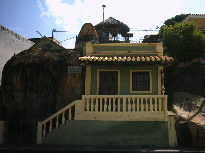
A typical restaurant of the city
-
A view of Ciudad Bolívar from La Carioca market
-

Government Palace with christmas decoration
-

Parochial House
-

Jimmy Angel´s original plane, at José Tomás de Heres airport
-

A typical street of the city
Districts
Ciudad Bolívar Districts Hueco Lindo • Historical Zone • La Milagrosa • La Shell • El Perú • Las Piedritas • La Sabanita • Vista Hermosa • La Paragua • Los Próceres • Los Pomelos • Los Coquitos • Los Aceiticos • Primero de Mayo • Las Flores • Agua Salada • Las Brisas • Jobo Liso • San Rafael • Centurión • Perro Seco • Paseo Orinoco • Mango Asao • Barrio Ajuro • Las Moreas • Cañafístola • La Dinamita • Nueva Guayana • La Lorena • Vuelta al cacho • Paseo Simón Bolívar • Brisas del Orinoco • Brisas del Sur • Brisas del Este • Maipure • El Mirador • San Simón • El Samán • Negro Primero • Las Beatrices • Santa Fe • Caprenco • Virgen del Valle • El Mereyal • Marhuanta • El Algarrobo • La Lucha • Agosto Méndez • Llano Alto • Bicentenario • Giraluna • David Morales Bello • Vista Alegre • La Campiña • Rómulo Gallegos See also
References
- ^ History of Ciudad Bolívar
- ^ Law and government
- ^ Geography of Ciudad Bolívar
- ^ Economy and services of Ciudad Bolívar
- ^ Feria del Orinoco
- ^ Plaza Bolívar
- ^ San Isidro Museum
- ^ Parochial House
- ^ House of the Congress of Angostura
- ^ Ciudad Bolívar Cathedral
- ^ (Spanish) Old prison
- ^ Government Palace
- ^ Piar house
- ^ Manuel Piar life
- ^ Jesús Soto Museum of Modern Art
- ^ Universidad de Oriente
- ^ Universidad Nacional Experimental de Guayana
External links
- Bolivar's message to the Congress of Angostura
- (Spanish) Ciudad Bolívar at Venezuelatuya.com
- (Spanish) Images of Ciudad Bolívar
 State capitals of Venezuela
Capital, state Puerto Ayacucho, Amazonas
Barcelona, Anzoátegui
San Fernando de Apure, Apure
Maracay, Aragua
Barinas, Barinas
Ciudad Bolívar, BolívarBold indicates national capital. Categories:- Ciudad Bolívar
- Bolívar (state)
- Populated places in Venezuela
- 1595 establishments


Wikimedia Foundation. 2010.