- Peninsula State Park
Geobox|Protected area
name = Peninsula State Park
category =Wisconsin State Park
category_iucn = V
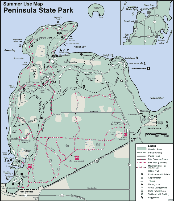
image_caption = Peninsula State Park summer map.
country = United States
country_
state = Wisconsin
state_
state_type = State
region_type = County
region = Door
city_type = City
location = Fish Creek
lat_d = 45
lat_m = 9
lat_s = 4
lat_NS = N
long_d = 87
long_m = 13
long_s = 3
long_EW = W
area_unit = acre
area_imperial = 3776
area_round = 1
established = 1909
map_locator = Wisconsin

management_body =Wisconsin Department of Natural Resources Peninsula State Park is a convert|3776|acre|km2|sing=on
Wisconsin state park with eight miles (13 km) ofGreen Bay shoreline in Door County. Peninsula is the third largest state park inWisconsin . Nearby Fish Creek has been referred to as the "Cape Cod of the Midwest" because of its quaint shops and beautiful shoreline.History
Peninsula State Park was established in 1909. The state of Wisconsin purchased this land for less than $20 an acre and in 1910 the state legislature officially established it as a state park. By 1914, the campground started gaining popularity and two convert|70|ft|m|sing=on high observation towers were being built by the
Civilian Conservation Corps at Svens Bluff as well as Eagle Bluff; one served as a tourist attraction the other as a lookout for forest fires. In 1921 park manager Albert E. Doolittle laid out a 9-hole golf course on the north-west corner of the park, overlooking Ephraim Harbor. A memorial pole was built on the course in 1927 and in 1931 Potawatomi Chief Simon Kahquados was buried at the pole.By 1934 flush toilets and running water were added. The winter warming house on Bluff Road was converted into the White Cedar Nature Center that same year. In 1982 Sunset Bike Trail was surfaced, computers began to be used for reservations, and an irrigation system was installed on the golf course (now 18 holes). In 1992 the first deer hunt was held on the park grounds. In 2001, tree thinning was started and eventually completed in Tennison Bay.
Campgrounds
Nicolet Bay
Nicolet Bay is divided into two parts, North and South. The Nicolet Bay camping area has 188 sites, 33 of which have electricity. There are 4 shower/flush toilet buildings with one cold water flush toilet building at the north end. Nicolet Bay is the location of the park's only sandy beach, which is popular with campers and is very crowded during warm summer days. The privately owned and operated Camp Store is located on the beach, along with quick service food and beverage, kayak/canoe/bike rentals and a public boat launch.
Tennison Bay
Tennison Bay is the largest campground in the park; it has 188 campsites, 56 of which are electric. Tennsion has two shower/bathroom facilities and three flush toilet facilities (without showers). A playground and kayak launch are at the north end of the campground. Tennison is the only campground that remains open year-round; a portion of sites are available for winter reservations.
Weborg Point
Weborg is Peninsula's smallest campground; it has has 12 electric sites and one shower/toilet building. These sites are often popular with RV and trailer campers. Weborg is near the park's Fish Creek entrance and has views of Fish Creek Town Center. A concrete pier at the tip of the campground is popular with recreational fishermen and the nearby Weborg Point shelter is available for reservations.
Welckers Point
Welckers Point is an 81-site non-electric campground located at the northern peninsula of the park. Welckers is a popular camping area for campers with tents and small trailers because of the heavily-wooded nature of the surrounding forest. Welckers is at the head of many hiking and biking trails (including a path to Nicolet Beach) and has a reservable shelter just outside the campground, which is a popular place for visitors to view bats 30 minutes after sunset during summer evenings.
Points Of Interest
Eagle Bluff Light
The
Eagle Bluff Light , also known as Eagle Bluff Lighthouse, is alighthouse located near Fish Creek in Peninsula State Park in Door County, Wisconsin. Construction was authorized in 1866 by PresidentAndrew Johnson , but the lighthouse was not actually It built until 1868 at a cost of $12,000. It was automated in 1926. The former lighthouse keeper's home has been a museum since 1963. Park admission and a donation is required to tour the lighthouse.Eagle Tower
Eagle Tower is a convert|75|ft|m|sing=on observation tower located atop the convert|180|ft|m|sing=on
limestone Eagle Bluff. The tower offers views of the park, surrounding islands, and theMichigan shoreline. Originally the tower was built as an observation platform for forest fires but became popular as a tourist attraction. The Tower was replaced by in the 1930s and refurbished once again in 2004.American Folklore Theatre
American Folklore Theatre (AFT) is located within the woods of Peninsula State Park and is accessible by biking or walking. Original musical comedies are performed Monday through Saturday nights during the summer. It is estimated that more than 50,000 people attend the musicals each a year.Horseshoe Island
Horseshoe Island is the only nearby island that is owned by the State of Wisconsin. The island is in the
Bay of Green Bay and is accessible by private boat. It has no establishments other than a pit toilet, a hiking trail and the foundation of a lodge that was once occupied by the Folda family in the 1890s. [ [http://www.dnr.wi.gov/org/land/parks/specific/peninsula/special.htm#horseshoe WDNR - Peninsula State Park's Specialties ] ] [ [http://www.dnr.wi.gov/org/land/parks/specific/peninsula/water.htm#horseshoe WDNR -Water Recreation at Peninsula Park ] ] The French explorerJean Nicolet reportedly landed briefly on the island. [ [http://www.baypointinn.com/history.htm History ] ]unset Bike Trail
Sunset Bike Trail is a convert|5.1|mi|km|sing=on paved/gravel trail which snakes through Peninsula's hardwoods and marshes. The entire route is convert|9.5|mi|km long and takes about one hour to bike and three hours to hike. Sunset Bike Trail provides a safe and scenic alternative to Shore Road for bikers and hikers. Riders are not required to have a Wisconsin State Trail Pass.
Notes
External links
* [http://www.dnr.state.wi.us/org/land/parks/specific/peninsula/index.htm Peninsula State Park website]
* [http://www.peninsulafriends.org Friends of Peninsula State Park]

Wikimedia Foundation. 2010.