- North Sydney, New South Wales
-
North Sydney
Sydney, New South Wales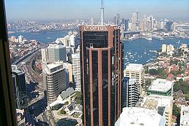
North SydneyPopulation: 6,060(2006)[1] Postcode: 2060 Area: 1.4 km² (0.5 sq mi) Location: 3 km (2 mi) north of Sydney CBD LGA: North Sydney Council State District: North Shore Federal Division: North Sydney Suburbs around North Sydney: Crows Nest Cammeray Cammeray Waverton North Sydney Neutral Bay McMahons Point Lavender Bay Milsons Point North Sydney is a suburb and commercial district on the Lower North Shore of Sydney, in the state of New South Wales, Australia. North Sydney is located 3 kilometres north of the Sydney central business district[2] and is the administrative centre for the local government area of North Sydney Council.
Contents
History
Aborigines on the southern side of Port Jackson (Sydney Harbour) called the north side warung which meant the other side, while those on the northern side used the same name to describe the southern side.[citation needed]
The first name used by European settlers was Hunterhill, named after a property owned by Thomas Muir (1765–1799), a Scottish political reformer. He purchased land in 1794 near the location of north pylon of the Sydney Harbour Bridge is now located, and built a house which he named after his childhood home. This area north to Gore Hill became known as St Leonards.[citation needed] The township of St Leonards was laid out in 1836 in what is now North Sydney, bounded by what is now Miller, Walker, Lavender and Berry Streets. By 1846 there were 106 houses here and by 1859, the commercial centre had extended from Milsons Point to Miller Street. A bus service operated by Jeremiah Wall ran between Milsons Point and North Sydney Shops, and North Sydney thus developed its own identity.
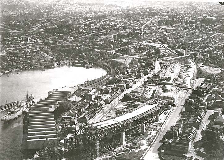
 Aerial view of North Sydney during construction of the Sydney Harbour Bridge.
The North Sydney municipality was incorporated in 1890 and after naming disputes, North Sydney was settled upon. The post office which opened in 1854 as St Leonards was changed to North Sydney in 1890. The first public school which opened in 1874 as St Leonards was renamed North Sydney in 1910.[3]
North Sydney underwent a dramatic transformation into a commercial hub in 1971-72. In this period no less than 27 skyscrapers were built.[4]
Trams
Main article: Trams in SydneyThe history of the North Sydney tramway system can be divided into three periods - the first from the original opening in 1886 to 1909, when the McMahons Point line opened. The second period covers the time until the Wynyard line was opened across the Sydney Harbour Bridge in 1932, and the third from then until the general closure of the system in 1958.[5]
The first part of the North Sydney tramway system was a double-track cable tramway which commenced at the original Milsons Point Ferry wharf, located where the north pylon of the Harbour Bridge is now. The line originally extended via Alfred St (now Alfred Street South), Junction St (now Pacific Highway), Blue St and Miller Sts to the engine house and depot in Ridge St. It used cable grip cars called "dummies" and un powered trailer cars.
A feature of these lines was the underground tram terminus at Wynyard railway station (the only one in Australia), and the tracks over the Sydney Harbour Bridge. Trams ran from Blue St, North Sydney over a now-demolished steel arch bridge over the Harbour Bridge Roadway, then over the eastern side of the harbour bridge (now road lanes), through a tram platform at Milsons Point railway station, before descending underground into platforms 1 and 2 of Wynyard station.
Heritage
 Mercedes, Gothic Revival home, Walker Street
The following buildings are on the Register of the National Estate:[6]
- Christ Church, Walker and Lavender Streets
- Church of England Rectory, Lavender Street
- St Francis Xavier's War Memorial Church, Mackenzie Street
- St Francis Xavier's Presbytery, Mackenzie Street
- St Francis Xavier's Church School Hall, Mackenzie Street
- Chinese Christian Church, Alfred Street
- Former North Sydney Technical School (now Greenwood Hotel), Blue Street
- St Peter's Presbyterian Church and Manse, Blues Point Road
- Graythwaite, Union Street (currently under development [7] by Shore School, the new owners, causing public outcry [8])
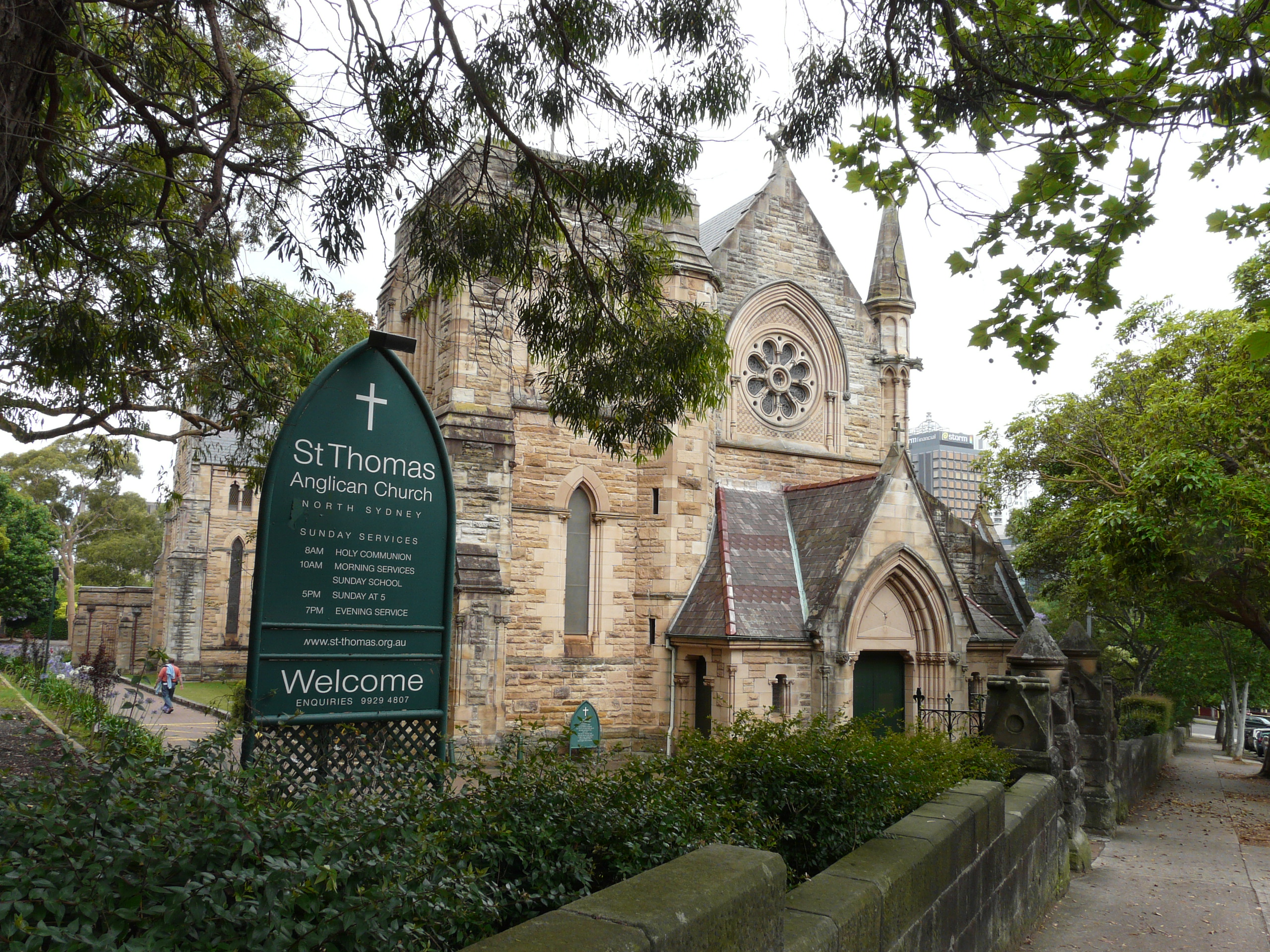
- St Thomas's Church of England, West and Church Streets
- St Thomas's Kindergarten Hall, Church and McLaren Streets
- St Thomas's Church Rectory, McLaren Street
- Don Bank, Napier Street
- North Sydney Post Office, Pacific Highway and Mount Street
- Houses: 11-37 Walker Street and 20-30 Walker Street
- Mercedes, 9 Walker Street
Commercial area
 North Sydney's high-rise commercial district
The commercial district of North Sydney includes the second largest concentration of office buildings in New South Wales,[citation needed] with a large representation from the advertising and information technology industries. Advertising, marketing businesses and associated trades such as printing have traditionally dominated the business life of the area though these have been supplanted to a certain extent by information technology businesses. Corporations whose offices are in North Sydney include Polltraxx Protection Services, Cisco Systems, Novell, Sun Microsystems, AGL, AAMI and until October 2007, Optus. Unlike other major suburban hubs within the Sydney metropolitan area, North Sydney has limited shopping facilities and almost no Sunday trading. There are only two medium sized supermarkets (Aldi & IGA). The main shopping complex is the Greenwood Plaza, which is connected to North Sydney station.[9] Berry Square is another shopping centre in Berry Street, formerly known as North Sydney Shopping World.[10]
Transport
North Sydney is directly linked to the Sydney CBD by road and rail across the Sydney Harbour Bridge. North Sydney railway station is on the North Shore Line and the Northern Line of the City Rail network. The Warringah Freeway links North Sydney south to the Sydney CBD and north to Chatswood, New South Wales. High Street, North Sydney is a wharf stop on the Neutral Bay ferry service, which is part of the Sydney Ferries network.
Places of worship
 St Mary's Church
Churches include St Mary's Catholic Church on Miller Street, St Francis Xavier's War Memorial Church in Mackenzie Street, St Thomas Anglican Church on West and Church Streets, Christ Church on Walker and Lavender Streets, St Peter's Presbyterian Church and Manse on Blues Point Road and Chinese Christian Church on Alfred Street.
A Hare Krishna temple is located on the corner of Falcon Street and Miller Street.[11]
Schools
Primary schools include North Sydney Demonstration School and St Marys Primary School. High schools include the public North Sydney Boys High School and North Sydney Girls High School, the Catholic Marist College North Shore and Monte Sant' Angelo Mercy College and independent schools Wenona School and Sydney Church of England Grammar School (Shore).
St Aloysius' College of Milson's Point and Loreto Kirribilli are also within the confines of the North Sydney Local Government Area. Post-secondary education providers include the Australian Catholic University, Raffles College of Design and Commerce and Billy Blue College.
Landmarks
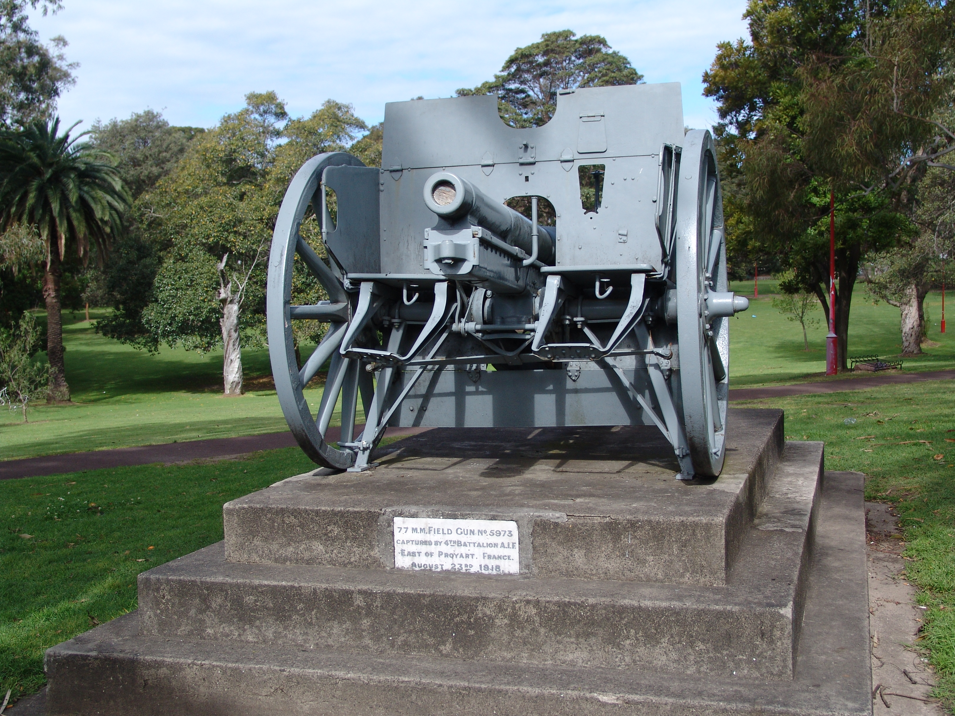
 A WWI German Field Gun near North Sydney Oval. The State War Trophy Committee allocated the gun to Council in 1921. It was unveiled by Major-General Sir Granville Ryrie[1].
- Museum at Mary MacKillop Place, which tells the story of Australia's first Catholic saint
- Don Bank Museum, devoted to the history of the local area
- Greenwood Plaza shopping complex, built under the historic Greenwood Hotel (formerly a public school, founded 1878 and renamed after its Principal)
- North Sydney Railway Station
- North Sydney Oval
- Stanton Library
- Walker Street Cinema
Sport and recreation
St Leonards Park which includes North Sydney Oval No 1 and 2 is the suburbs major recreation area, popular among joggers and those wishing to walk their dogs. North Sydney Ovals are notably cricket pitches during the summer and the home ground for the Northern Suburbs Rugby Union Club and the North Sydney Bears Rugby League Club during the winter.
The Norths Pirates Junior Rugby Union Club, is North Sydneys local junior village rugby union team who play all home games at Tunks Park in the adjoining suburb of Cammeray together with North Sydney Brothers, a junior rugby league club and the rugby league teams of Marist College North Shore.
- North Sydney Bears (rugby league team based in the area)
- North Sydney Cricket Club
- Norths Pirates Junior Rugby Union [12]
- Northern Suburbs Rugby Club
- UTS Northern Suburbs Athletic Club
- Gordon-North Sydney Hockey Club
During the 2000 Summer Olympics, the city was the starting point of the marathon course that would end 26.2 mi (42.2 km) later at the Olympic Stadium in Sydney.[13]
Population
Notable residents
- Billy Blue - a convict after whom several places were named, such as Blues Point
- Henry Lawson - poet
Governance
The local government area of North Sydney Council includes the suburb of North Sydney and the surrounding suburbs of Crows Nest, Wollstonecraft, Waverton, Neutral Bay, McMahons Point, Kirribilli, Cremorne (divided between North Sydney & Mosman), and Cammeray.
Gallery
Heritage
-

North Sydney Post Office, Pacific Highway
-

Rag and Famish Hotel
-

Mary Mackillop museum, Mount Street
-

Graythwaite, Union Street
Places of worship
-

Mary Mackillop Memorial Chapel, Mount Street
-

St Francis Xavier Church
-

St Francis Xavier Parish Centre
-

St Peters Church
-

St Thomas' Church
References
- ^ Australian Bureau of Statistics (25 October 2007). "North Sydney (State Suburb)". 2006 Census QuickStats. http://www.censusdata.abs.gov.au/ABSNavigation/prenav/LocationSearch?collection=Census&period=2006&areacode=SSC11741&producttype=QuickStats&breadcrumb=PL&action=401. Retrieved 14 October 2009.
- ^ Gregorys Street Directory, Gregorys Publishing Company, 2007
- ^ The Book of Sydney Suburbs, Compiled by Frances Pollon, Angus & Robertson Publishers, 1990, Published in Australia ISBN 0-207-14495-8, page 191
- ^ Sydney Architecture
- ^ D Keenan: The North Sydney lines of the Sydney tramway system. Transit Press November 1987 ISBN 0 909338 05 1
- ^ The Heritage of Australia, Macmillan Company, 1981, p.2/45-47
- ^ http://majorprojects.planning.nsw.gov.au/index.pl?action=view_job&job_id=4267
- ^ http://www.sadatgraythwaite.com
- ^ www.greenwoodplaza.com.au
- ^ www.northsydneysw.com.au
- ^ http://www.iskcon.com.au
- ^ See http://www.northspirates.rugbynet.com.au/
- ^ 2000 Summer Olympics official report. Volume 1. p. 106.
External links
- Monte Sant'Angelo Mercy College
- Wenona School
- Marist College North Shore
- North Sydney Boys High School
- North Sydney Girls High School
- Billy Blue College & Billy Blue Creative
- 2001 Census Information
Suburbs of the North Sydney Local Government Area · North Shore · Sydney Cammeray · Cremorne · Cremorne Point · Crows Nest · Kirribilli · Kurraba Point · Lavender Bay · McMahons Point · Milsons Point · Neutral Bay · North Sydney · St Leonards · Waverton · WollstonecraftList of Sydney suburbs Venues of the 2000 Summer Olympics Sydney Olympic Park NSW Tennis Centre · Olympic Stadium · State Hockey Centre · State Sports Centre · Sydney Showground (Sydney Baseball Stadium) · Sydney International Archery Park · Sydney International Aquatic Centre · Sydney Super DomeSydney Blacktown Olympic Park · Bondi Beach · Centennial Parklands · Dunc Gray Velodrome · Fairfield City Farm · Marathon course · North Sydney · Olympic Sailing Shore Base · Penrith Whitewater Stadium · Ryde Aquatic Leisure Centre · Sydney Convention and Exhibition Centre · Sydney Entertainment Centre · Sydney Football Stadium · Sydney International Equestrian Centre · Sydney International Regatta Centre · Sydney International Shooting Centre · Sydney Opera HouseOutside Sydney Coordinates: 33°50′23″S 151°12′19″E / 33.83965°S 151.20541°E
Categories:- Suburbs of Sydney
- 2000 Summer Olympic venues
- Olympic athletics venues
- Central business districts in Australia


Wikimedia Foundation. 2010.