- Auglaize River
Infobox River
river_name = Auglaize River
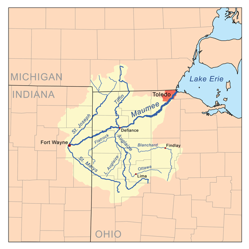
caption = Map of the Maumee River watershed showing the Auglaize River.
origin = 2 mi (3.2 km) south of Harrod
mouth =Maumee River at Defiance
basin_countries =
length = 100 mi (160 km) [http://www.dnr.state.oh.us/streams/ "A Guide to Ohio Streams."] [http://www.dnr.state.oh.us/streams/chapter10.pdf Chapter 10: Major Ohio Watersheds (pdf)] ]
elevation = ~ 990 ft (302 m) U.S. Geological Survey. Harrod quadrangle, Ohio. 1:24,000. 7.5 Minute Series. Washington D.C.: USGS, 1961.]
mouth_elevation = ~ 665 ft (203 m) U.S. Geological Survey. Defiance East quadrangle, Ohio. 1:24,000. 7.5 Minute Series. Washington D.C.: USGS, 1988.]
discharge =
watershed = 2337 mi² (6053 km²)The Auglaize River is a tributary of the
Maumee River , approximately 100 mi (160 km) long, in northwesternOhio in theUnited States . It drains a primarily rural farming area in the watershed ofLake Erie . The name of the river either comes from aShawnee phrase meaning "fallen timbers" or a French term for "frozen water."It rises in southeastern Allen County, approximately 10 mi (15 km) southeast of Lima and 12 mi (20 km) north of Indian Lake. It flows southwest to Wapakoneta, then generally north in a zigzag course, past Delphos, Fort Jennings and Oakwood. It joins the Maumee from the south at Defiance, approximately 2 mi (3 km) east of the mouth of the
Tiffin River .It receives the Ottawa River from the southeast in northwestern Putnam County, northwest of Lima. It receives the Blanchard River in eastern Putnam County. It receives the
Little Auglaize River from the south in southeastern Paulding County. It receivesFlatrock Creek from the west in northeastern Paulding County.During the days of the
Ohio Country in the 18th century, the area around the river was inhabited by the Ottawa.Fort Amanda , constructed along the river southwest of Lima in 1812, was an important American outpost during theWar of 1812 . Fort Defiance was constructed in 1812 near the confluence of the Auglaize and the Maumee where theBattle of Fallen Timbers was fought.Variant names
According to the
Geographic Names Information System , the Auglaize River has also been known as: Gnis|1065901]
*Au Glaize River
*Auglaise River
*Cowthenake sepe
*Glaize River
*Grand Au Glaze River
*Grand Glaise River
*Grand Glaize River
*Great au Glaise River
*Qusquasrundeeee also
*
List of Ohio rivers
*Chief Pontiac
*Grandglaize Creek , tributary of theLake of the Ozarks which is also uses the Auglaize nameReferences
External links
* [http://digital.library.okstate.edu/kappler/Vol2/treaties/ott0335.htm 1831 Treaty with Ottawa]
* [http://www.galafilm.com/1812/e/catalogues/fort330.html Fort Defiance]
* [http://www.findlay.edu/academics/cola/hist/classprojects/hist390/rister.html Findlay University: Fort Amanda]
Wikimedia Foundation. 2010.