- Oval barrow
-
An oval barrow is the name given by archaeologists to a type of prehistoric burial tumulus of roughly oval shape.
In the British mid to late Neolithic and early Bronze Age, oval barrows may indicate a transition between earlier long barrows with multiple burials and the later, more individual round barrows.[citation needed]
Judging from those sited in or near the Thames Valley, there is much doubt as to how oval barrows are related to the burials found within them and funerary practices, because there can be a long gap of many years between an original burial and the construction of the barrow.[1]
Contents
Buckinghamshire[2]
Whiteleaf Hill
There is a neolithic oval barrow near the top of Whiteleaf Hill, Monks Risborough, Buckinghamshire (National Grid: SP 822040), which was first excavated by Sir Lindsay Scott between 1934 and 1939 and re-excavated from 2002 to 2006 by Oxford Archaeology (assisted by the Princes Risborough Countryside Group). The mound is roughly oval, but indented on the north-eastern side, making it somewhat kidney-shaped.
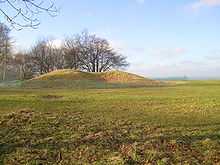 Neolithic Barrow on Whiteleaf Hill, Monks Risborough, Bucks
The barrow held only one burial and radio-carbon dating has shown that the death, the burial and the building of the mound probably all took place within the period 3,750-3,100 B.C., but at different times within that period. The remains appeared to have been placed between two large vertical posts, 1.2 metres apart. Pottery shards and animal bones were found at the core of the mound and the excavators suggest that these came from ceremonial feasting when the mound was built.[3]
Dorney Reach
This is a mid-neolithic barrow dated to the approximate period 3300-2800 BC. Previously known only from a cropmark, magnetometry and resistivity surveys have produced more detailed information about this unexcavated site, which is on level ground on the flood plain of the River Thames at SU 9170 7935, 250 metres from the river. They reveal an oval ditch with external dimensions of about 20 by 12.5 metres. The axis lies NNE-SSW. Indications of two pits at the centre may represent a split-timber mortuary structure, as was found at Whiteleaf.[4]
Marsh Lane East (site 2)
It is believed that this was originally a neolithic oval barrow, but it was re-cut in the Bronze Age, so that little of the original barrow remains.[5]
Oxfordshire
Abingdon[6]
Kent
.
Yorkshire
.
Books mentioned in the Notes
Bradley R. (1992), The excavation of an oval barrow beside the Abingdon causewayed enclosure, Oxfordshire, Proceedings of the Prehistoric Society vol.58
Childe, V.G. and Isobel Smith: The Excavation of a Neolithic Barrow on Whiteleaf Hill, Bucks in Proceedings of the Prehistoric Society for 1954, (New Series, Vol.XX, no.8), pp.212-30
Hey, Gill, Caroline Dennis & Andrew Mayes: Archaeological Investigations on Whiteleaf Hill, Princes Risborough, Buckinghamshire, 2002-6 in Records of Buckinghamshire, Vol 47 part 2, pp.1-80 (Buckinghamshire Archaeological Society, Aylesbury. 2007)
Lamdin-Whymark, Hugh: The Residue of Ritualised Action: Neolithic Deposition Practices in the Middle Thames Valley (British Archaeological Reports - British Series no.466. 2008)
Lamdin-Whymark, Hugh and Darko Maricevic: On the Survey of a Neolithic oval Barrow at Dorney Reach, Buckinghamshire in Records of Buckinghamshire, Vol 49, pp.1-7 (Buckinghamshire Archaeological Society, Aylesbury. 2009)
Notes- ^ See Hey et al on Whiteleaf barrow and Lamdin-Whymark on that at Dorney Reach
- ^ The three oval barrows in the Middle Thames Valley are discussed in Lamdin-Whymark (2008). See especially pp.165-7
- ^ See Childe & Smith for the original excavation and Hey et al. for the 2007 report
- ^ See Lamdin-Whymark (2009)
- ^ Lamdin-Whymark & Maricevik (2008) p.166
- ^ See Bradley
Categories:- Monument types
- Barrows

Wikimedia Foundation. 2010.