- Concord Point Light
-
Concord Point Light 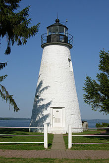
Concord Point Light Location Havre de Grace, Maryland Coordinates 39°32′26.52″N 76°5′5.28″W / 39.5407°N 76.0848°WCoordinates: 39°32′26.52″N 76°5′5.28″W / 39.5407°N 76.0848°W Year first constructed 1827 Year first lit 1827 Automated 1920 Deactivated 1975 Construction Granite Tower shape Conical Markings / pattern Whitewash Height 36 feet (10.97 m) Original lens Winslow Lewis reflectors Current lens Fifth-order Fresnel lens Characteristic Fixed Havre de Grace Lighthouse

Location: Concord and Lafayette Streets, Havre de Grace, Maryland Coordinates: 39°32′26.52″N 76°5′5.28″W / 39.5407°N 76.0848°W Area: 0.1 acres (0.040 ha) Built: 1827 Architect: John Donohoo Governing body: United States Coast Guard NRHP Reference#: 76000999[1] Added to NRHP: April 2, 1976 Concord Point Light is a lighthouse in Havre de Grace, Maryland, overlooking the point where the Susquehanna River flows into the Chesapeake Bay, an area of increasing navigational traffic at the time it was constructed in 1827. It was built by John Donahoo who built many lighthouses in Maryland.[2] It is the most northerly lighthouse in Maryland and the oldest continuously-operated lighthouse in Maryland.
Contents
Description
Concord Point Light is a 36-foot (10.97 m) tower that was built in 1827. It is the second oldest tower lighthouse on the Chesapeake Bay and the oldest continuously-operated lighthouse in Maryland.[citation needed] The lighthouse is constructed of Port Deposit granite. The walls are 31 inches (79 cm) thick at the base and narrow to 18 inches (46 cm) at the parapet. John Donahoo also built the keeper's dwelling (known as the O'Neill House) across the street.
The lantern was originally lit with 9 whale oil lamps with 16-inch (41 cm) tin reflectors. In 1854, a sixth-order Fresnel lens was installed. This was later upgraded to a fifth-order Fresnel lens. The lighthouse was automated in 1920.
History
The O'Neill family served as keepers at Concord Point from 1827 to the mid-1900s. The first O'Neill, John, defended the site of the lighthouse during the War of 1812. Local documents describe the lighthouse area as being "seriously blighted" by 1924, and apparently remained that way for many years. The lighthouse was decommissioned by the Coast Guard in 1975 and soon after that the lens was stolen.[citation needed] The structure was added to the National Register of Historic Places in 1976. Extensive restoration began in 1979, and is ongoing, with plans to turn the old keeper's dwelling into a museum.[citation needed]
The lighthouse is maintained by The Friends of Concord Point Lighthouse. The tower is open to visitors Saturdays, Sundays and holidays from 1:00 p.m. until 5 p.m., May through October. The grounds are open year-round.
References
- ^ "National Register Information System". National Register of Historic Places. National Park Service. 2009-03-13. http://nrhp.focus.nps.gov/natreg/docs/All_Data.html.
- ^ Simms, William Q. (April 2001). "Two Lights on the Hill". Lighthouse Digest. http://www.lhdigest.com/Digest/StoryPage.cfm?StoryKey=1004. Retrieved 2006-12-28.
See also
External links
- Concord Point Lighthouse - official site
- Lighthouse Friends: Concord Point Light - photos and description
- Chesapeake Chapter U.S. Lighthouse Society - description and driving directions
- Trip report to Concord Point Light
- Rowlett, Russ. "Lighthouses of the United States: Maryland". The Lighthouse Directory. University of North Carolina at Chapel Hill. http://www.unc.edu/~rowlett/lighthouse/md.htm.
- Chesapeake Bay Lighthouse Project - Concord Point Light
U.S. National Register of Historic Places in Maryland Lists by county Allegany • Anne Arundel • Baltimore County • Calvert • Caroline • Carroll • Cecil • Charles • Dorchester • Frederick • Garrett • Harford • Howard • Kent • Montgomery • Prince George's • Queen Anne's • Somerset • St. Mary's • Talbot • Washington • Wicomico • Worcester
Lists by city Other lists Keeper of the Register • History of the National Register of Historic Places • Property types • Historic district • Contributing property Categories:- Lighthouses on the National Register of Historic Places in Maryland
- Lighthouses in Maryland
- Buildings and structures completed in 1827
- Buildings and structures in Harford County, Maryland
- Museums in Harford County, Maryland
- Lighthouse museums in Maryland
- Transportation in Harford County, Maryland


Wikimedia Foundation. 2010.