- Geography of California
-
Covering an area of 163,696 sq mi (423,970 km2), California is geographically diverse. The Sierra Nevada Mountains, the fertile farmlands of the Central Valley, and the arid Mojave Desert of the south are some of the major geographic features of this U.S. state. It is home to some of the world's most exceptional trees: the tallest (coast redwood), most massive (Giant Sequoia), and oldest (bristlecone pine). It is also home to both the highest (Mt. Whitney) and lowest (Death Valley) points in the 48 contiguous states.
The state is generally divided into Northern and Southern California, although the boundary between the two is not well defined. San Francisco is decidedly a Northern California city and Los Angeles likewise a Southern California one, but areas in between do not often share their confidence in geographic identity. The US Geological Survey defines the geographic center of the state at a point near North Fork, California.
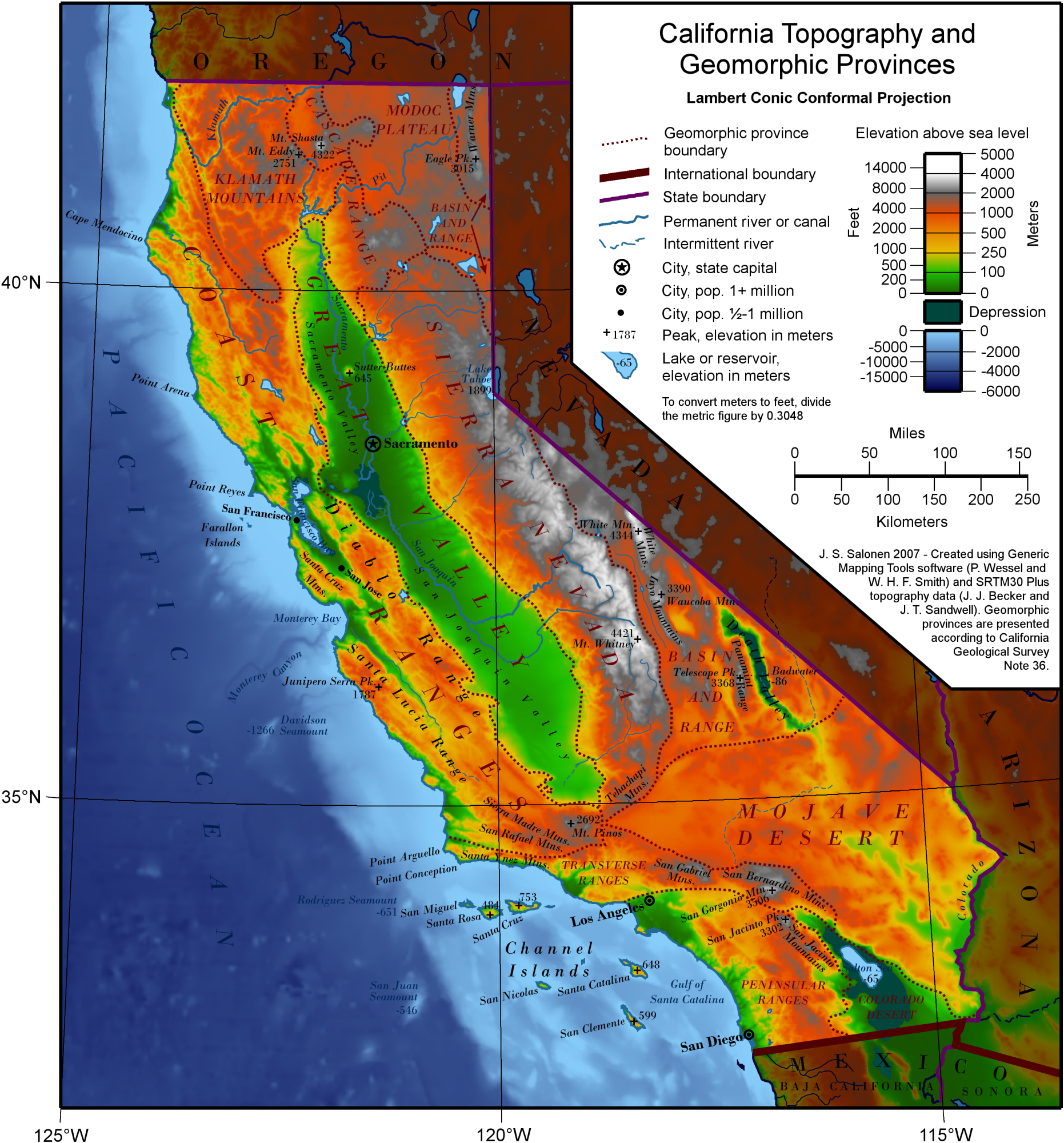
Earth scientists typically divide the state into eleven distinct geomorphic provinces with clearly defined boundaries. They are, from north to south, the Klamath Mountains, the Cascade Range, the Modoc Plateau, the Basin and Range, the Coast Ranges, the Central Valley, the Sierra Nevada, the Transverse Ranges, the Mojave Desert, the Peninsular Ranges, and the Colorado Desert. Here, the Los Angeles Basin, the Channel Islands, and the Pacific Ocean are treated as distinct regions.
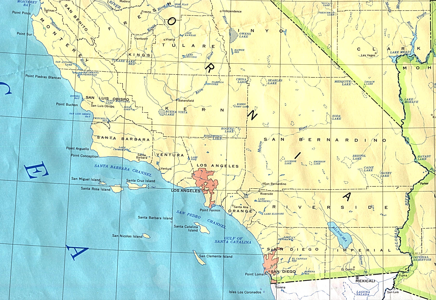
 Map of California topography and geomorphic provinces
Contents
Northern California
 Wedding Cake Peak and Thompson Peak
Klamath Mountains
The Klamath Mountains are a mountain range in northwest California and southwest Oregon, the highest peak being Thompson Peak (2,744 m / 9,002 ft) in Trinity County, California. They have a very varied geology, with substantial areas of serpentine and marble, and a climate summers with limited rainfall. As a consequence of the geology, they have a unique flora including several endemic or near-endemic species, such as Lawson's Cypress (Chamaecyparis lawsoniana), Foxtail Pine (Pinus balfouriana), Brewer's Spruce (Picea breweriana) and Kalmiopsis (Kalmiopsis leachiana).
Cascade Range
 Mount Shasta from Interstate 5
The Cascade Range is a mountainous region stretching from British Columbia in Canada down to the northern part of California. The Cascades (as they are called for short) are part of the Pacific Ring of Fire, the ring of volcanoes around the Pacific Ocean. All of the known historic eruptions in the contiguous United States have been from Cascade volcanoes. The last Cascade volcano to erupt in California was Lassen Peak, which erupted from 1914 to 1921. Lassen is the most southerly active volcano of the Cascade chain.
This region is located in the northeastern section of the state bordering Oregon and Nevada, mostly north of the Central Valley and the Sierra Nevada mountain range. The area is centered on Mount Shasta, near the Trinity Alps. Mount Shasta is a dormant volcano, but there is some evidence that it or Shastina, a smaller companion, erupted in the 18th Century.
Modoc Plateau
In the northeast corner of the state lies the Modoc Plateau, an expanse of lava flows at an altitude of 4,000 to 6,000 ft (1,200 to 1,800 m) with cinder cones, juniper flats, pine forests, and seasonal lakes. Nearly 1 million acres (4,000 km²) of the Modoc National Forest lie on the plateau between the Medicine Lake Highlands in the west and the Warner Mountains in the east. The plateau supports large herds of mule deer (Odocoileus Hemionus), Rocky Mountain Elk (Cervus Canadensis), and pronghorn antelope (Antilocapra Americana). There are also several herds of wild horses on the plateau. The Clear Lake National Wildlife Refuge and Long Bell State Game Refuge are located on the plateau as well. The Lost River watershed drains the north part of the plateau, while southern watersheds either collect in basin reservoirs or flow into the large Big Sage Reservoir, which sits in the center of Modoc County.
Basin and Range
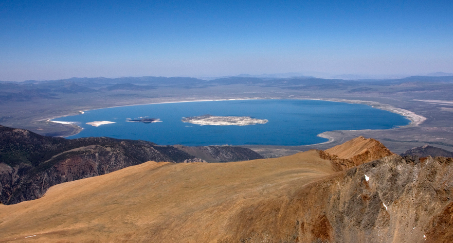
 Mono Lake
To the east of the Sierra is the Basin and Range geological province, which extends into Nevada. The Basin and Range is a series of mountains and valleys (specifically horsts and grabens), caused by the extension of the Earth's crust. One notable feature of the Basin and Range is Mono Lake, which is the oldest lake in North America. The Basin and Range also contains the Owens Valley, the deepest valley in North America (more than 10,000 feet (3 km) deep, as measured from the top of Mount Whitney).
In the eastern part of the state, below the Sierra Nevada, there is a series dry lake beds that were filled with water during the last ice age (fed by ice melt from alpine glaciers but never directly affected by glaciation; see pluvial). Many of these lakes have extensive evaporite deposits that contain a variety of different salts. In fact, the salt sediments of many of these lake beds have been mined for many years for various salts, most notably borax (this is most famously true for Owens Lake and Death Valley).
In this province reside the White Mountains, which are home to the oldest living thing in the world, the bristlecone pine.
Coast Ranges
 Skyline Boulevard, along the crest of the Santa Cruz Mountains
To the west of the Central Valley lies the Coast Ranges, including the Diablo Range, just east of San Francisco, and the Santa Cruz Mountains, to the south of San Francisco. The Coast Ranges north of San Francisco become increasingly foggy and rainy. These mountains are noted for their coast redwoods, which live within the range of the coastal fog, the tallest trees on Earth.
Central Valley
California's geography is largely defined by its central feature — the Central Valley, a huge, fertile valley between the coastal mountain ranges and the Sierra Nevada. The northern part of the Central Valley is called the Sacramento Valley, after its main river, and the southern part is called the San Joaquin Valley (
 /ˌsæn wɑːˈkiːn/), after its main river. The whole Central Valley is watered by mountain-fed rivers (notably the San Joaquin, Kings, and Sacramento) that drain to the San Francisco Bay system. The rivers are sufficiently large and deep that several inland cities, notably Stockton, California, and Sacramento, California are seaports.
The southern tip of the valley has interior drainage and thus is not technically part of the valley at all. Tulare Lake, once 570 square miles (1,476 square kilometers) and now dry and covered with agricultural fields, once filled much of the area.
Sierra Nevada
 Little Lakes Valley in the eastern Sierra Nevada
In the east of the state lies the Sierra Nevada, which runs north–south for 400 miles (640 km). The highest peak in the contiguous United States, Mount Whitney at 14,505 feet (4,421 m), lies within the Sierra Nevada. The topography of the Sierra is shaped by uplift and glacial action.
The Sierra has 200–250 sunny days each year, warm summers, fierce winters, and varied terrain, a rare combination of rugged variety and pleasant weather. The famous Yosemite Valley lies in the Central Sierra. The large, deep freshwater Lake Tahoe lies to the North of Yosemite. The Sierra is also home to the Giant Sequoia, the most massive trees on Earth.
The most famous hiking and horse-packing trail in the Sierra is the John Muir Trail, which goes from the top of Mt. Whitney to Yosemite valley, and which is part of the Pacific Crest Trail that goes from Mexico to Canada. The three major national parks in this province are Yosemite National Park, Kings Canyon National Park, and Sequoia National Park.
Southern California
Main article: Geography of Southern CaliforniaTransverse Ranges
 Mount San Gorgonio, the highest mountain in Southern California
 Even after the snow melts in San Bernardino, the San Bernardino Mountains in the background retain the snow.
Southern California is separated from the rest of the state by the east-west trending Transverse Ranges, including the Tehachapi, which separate the Central Valley from the Mojave Desert. Urban Southern California intersperses the valleys between the Santa Susana Mountains, Santa Monica Mountains and San Gabriel Mountains, which range from the Pacific Coast, eastward over 100 miles (160 km), to the San Bernardino Mountains, north of San Bernardino. The highest point of the range is Mount San Gorgonio at 11,499 feet (3,505 m). The San Gabriel Mountains have Mount Wilson observatory, where the redshift was discovered in the 1920s.
The Transverse Ranges include a series of east–west trending mountain ranges that extend from Point Conception at the western tip of Santa Barbara County, eastward (and a bit south) to the east end of the San Jacinto Mountains in western Riverside County. The Santa Ynez Mountains make up the westernmost ranges, extending from Point Conception to the Ventura River just west-northwest of Ojai, in Ventura County. Pine Mountain Ridge, Nordhoff Ridge–Topatopa Mountains, Rincon Peak–Red Mountain, Sulphur Mountain, Santa Paula Ridge, South Mountain–Oat Mountain–Santa Susana Mountains, Simi Hills, Conejo Mountains–Santa Monica Mountains are all part of the Western Transverse Ranges, in Ventura and western Los Angeles Counties.
The Liebre Mountains occupy the northwest corner of Los Angeles County, and represent a northwestern extension of the San Gabriel Mountains, both on the Pacific Plate side of the San Andreas Fault. The fault divides the San Gabriel Mountains from the San Bernardino Mountains further to the east in San Bernardino County.
It is possible to surf in the Pacific Ocean and ski on a mountain during the same winter day in Southern California.
Los Angeles Basin
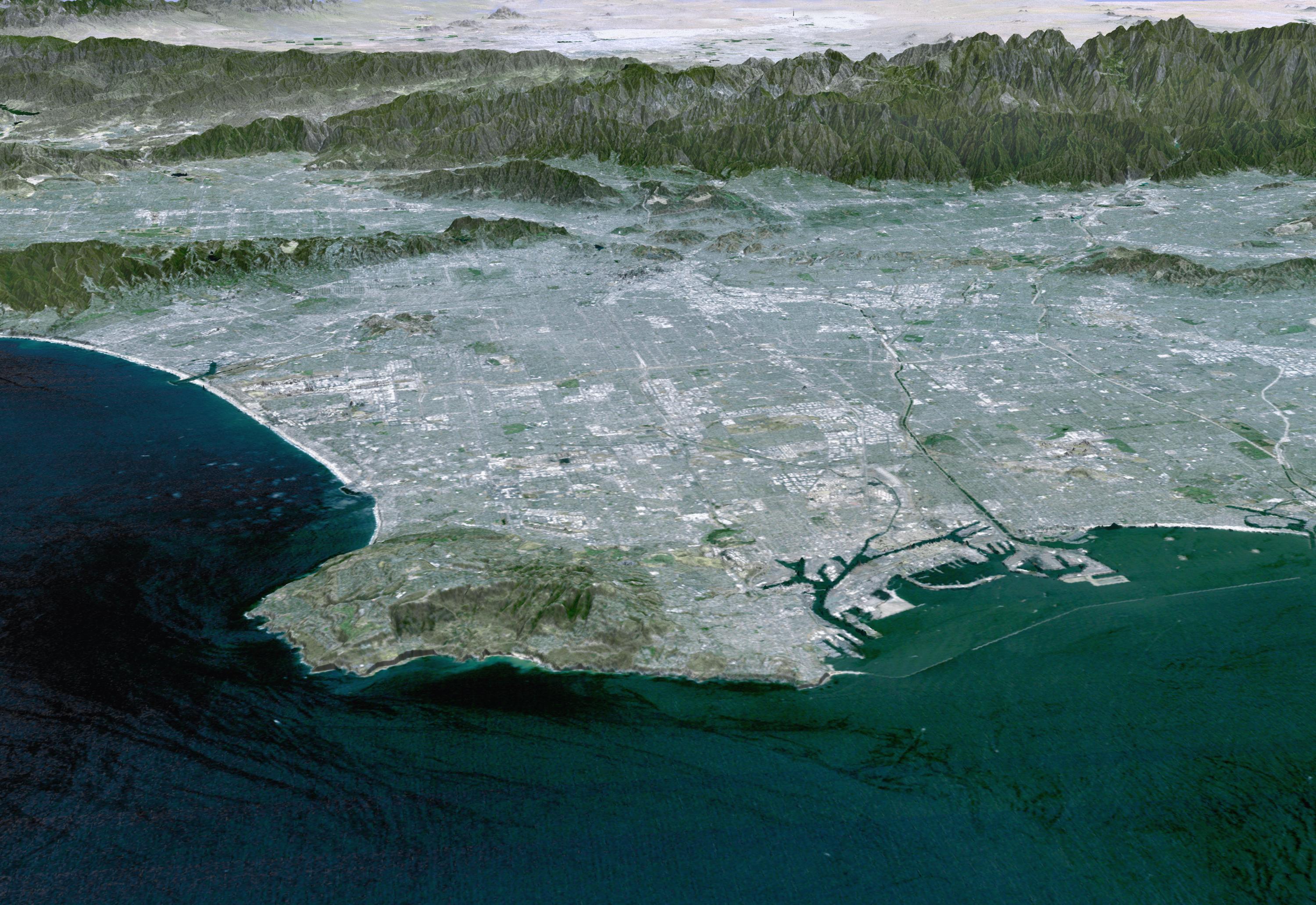
 Los Angeles Basin from space
For the last 15 million years, the Los Angeles, San Gabriel, and Santa Ana Rivers have deposited sediment from the Transverse Ranges along the southern coast of California. That sediment has formed the large, flat expanse of land known as the Los Angeles Basin, on which lives most of the population of Los Angeles and Orange Counties.
At its deepest point, near where the Los Angeles River meets the Rio Hondo, the sediment forming the basin is 6 miles (10 km) deep. The fact that so much sediment, which is naturally less stable than other geologic formations, underlies Los Angeles and its environs is one of the reasons earthquakes are such a danger to the metropolitan area.
Mojave Desert
 Badwater Basin: the lowest point in North America.
There are harsh deserts in the Southeast of California. These deserts are caused by a combination of the cold offshore current, which limits evaporation, and the rain shadow of the mountains. The prevailing winds blow from the ocean inland. When the air passes over the mountains, adiabatic cooling causes most water in the air to rain on the mountains. When the air returns to sea level on the other side of the mountains, it recompresses, warms and dries, parching the deserts. When the wind blows from inland, the resulting hot dry foehn winds are called the Santa Ana Winds.
The Mojave Desert is bounded by the peninsular Tehachapi Mountains on the Northwest, together with the San Gabriel and the San Bernardino Mountains on the Southwest. These Western boundaries are quite distinct, forming the dominant pie-slice shaped Antelope Valley in Southern California. The outlines of this valley are caused by the two largest faults in California: the San Andreas and the Garlock. The Mojave Desert extends Eastward into the State of Nevada. The Mojave Desert receives less than 6 inches (150 mm) of rain a year and is generally between 3,000 and 6,000 feet (1,000 and 2,000 m) of elevation. Areas such as the Antelope Valley desert which is a high desert received snow each year, in the past it could snow 2-3 times a year; however, recently snow level has declined significantly to once a year or less. Most of the towns and cities in the California portion of the Mojave are relatively small, except for Palmdale and Lancaster. However, some are quite famous like Barstow, a popular stop on the famous U.S. Route 66. The Mojave Desert also contains the lowest, hottest place in the Americas: Death Valley, where temperature normally approaches 120 °F (49 °C) in late July and early August.
Peninsular Ranges
The southernmost mountains of California are the Peninsular Ranges, which are East of San Diego and continue into Baja California (Mexico) in the Sierra San Pedro Martir. The Peninsular Ranges contain the Laguna Mountains, the San Jacinto Mountains, the Santa Rosa Mountains, the Santa Ana Mountains and the Palomar Mountain Range, notable for its famous Palomar observatory. San Jacinto Peak's eastern shoulder has a cable tram that runs from the desert floor to nearly the top of the mountain where riders can set off hiking or go cross-country skiing.
Colorado Desert
 The Coachella Valley Preserve
To the east of the peninsular ranges lie the Colorado and Sonoran Deserts, which extend into Arizona and Mexico.
The ground elevation is generally lower and in some areas was compressed downward, therefore the eastern Coachella and Imperial Valleys north of the U.S.-Mexican border are below sea level, the lowest community in the U.S. is Calipatria, California at 160 feet (49 m) below sea level.[citation needed]
One feature of the desert is the Salton Sea, an inland lake that was formed in 1905 when a swollen Colorado River breached a canal near the U.S.-Mexico border and flowed into the Salton Sink (Salton Basin) for almost two years. Today, the Salton Sea, a new version of historic Lake Cahuilla, remains as California's largest lake.
The Channel Islands and Palo Verdes
The Channel Islands are a group of islands off the coast of Southern California. They are divided into two groups, the Northern Channel Islands and the Southern Channel Islands. There are eight islands total:

Northern islands Southern islands Anacapa Island San Clemente Island San Miguel Island San Nicolas Island Santa Cruz Island Santa Barbara Island Santa Rosa Island Santa Catalina Island Four of the islands are located in Santa Barbara County, two are located in Ventura County, and two are located in Los Angeles County. The islands have relatively few people. The only island with a sizable settlement is Santa Catalina, with its towns of Avalon and Two Harbors. The islands of Anacapa, San Miguel, Santa Barbara, Santa Cruz, and Santa Rosa make up the Channel Islands National Park. There is also a marine sanctuary in the islands, the Channel Islands National Marine Sanctuary. The Channel Islands, and in particular San Nicolas Island, are famous for the Lost Woman of San Nicolas, or Juana Maria. This woman was the main character in the book Island of the Blue Dolphins by Scott O’Dell.
The Palos Verdes Peninsula has the same geologic origins as the Channel Islands.[citation needed] Once an island north of Santa Catalina, Palos Verdes is today connected to the mainland. Over millions of years, sediment from nearby mountains extended the shoreline of the Los Angeles Basin until it reached Palos Verdes.
Pacific Ocean
The Pacific Ocean lies to the west of California. Sea temperatures rarely exceed 65 °F (18 °C), even in summer, because of up-welling deep waters with dissolved nutrients. Therefore, most sea life in and around California more closely resembles Arctic, rather than tropical, biotopes. The sea off California is remarkably fertile, a murky green filled with fish, rather than the clear dead blue of most tropical seas. Before 1930, there was an extremely valuable sardine (herring) fishery off Monterey, but this was depleted, an event later famous as the background to John Steinbeck's Cannery Row.
Geology
Faults
Earthquakes occur due to faults that run the length of the Pacific coast, the largest being the San Andreas. Major historical earthquakes include:
- 1906 San Francisco earthquake
- Sylmar earthquake (1971)
- Loma Prieta earthquake (1989)
- Northridge earthquake (1994)
Coastal cities are vulnerable to tsunamis from locally generated earthquakes as well as those elsewhere in the Pacific Ring of Fire. The Great Chilean Earthquake tsunami (1960) killed one person and caused $500,000 to $1,000,000 dollars of damage in Los Angeles, damaged harbors in many coastal cities, and flooded streets in Crescent City.[1] Waves from the Alaskan Good Friday Earthquake of 1964 killed twelve people in Crescent City and caused damage as far south as Los Angeles.
California is also home to several volcanoes, including Lassen Peak, which erupted in 1914 and 1921, and Mount Shasta.
Continental drift
California, when only partially explored by the Spanish, was once thought to be an island, as when the southern Baja California peninsula is approached from the Gulf of California the land appears to the west. It is expected, through the motions of plate tectonics that the sea floor spreading now acting in the Gulf of California (also known as the Sea of Cortez) will eventually extend through Southern California and along the San Andreas fault to below San Francisco, finally forming a long island in less than 150 million years. (For comparison, this is also the approximate age of the Atlantic Ocean.) Predictions suggest that this island will eventually collide with Alaska after an additional 100 million years.
Climate
Main article: Climate of CaliforniaCalifornia's climate varies widely, from arid to subarctic, depending on latitude, elevation, and proximity to the coast. Coastal and Southern parts of the state have a Mediterranean climate, with somewhat rainy winters and dry summers. The influence of the ocean generally moderates temperature extremes, creating warmer winters and substantially cooler summers, especially along the coastal areas.
The state is subject to coastal storms, especially during the North American monsoon season. Dry weather during the rest of the year produces conditions favorable to wildfires. California hurricanes occur less frequently than their counterparts on the Atlantic Ocean. Higher elevations experience snowstorms in the winter months.
Floods are occasionally caused by heavy rain, storms, and snowmelt. Steep slopes and unstable soil make certain locations vulnerable to landslides in wet weather or during earthquakes.
See also
- 4000 meter peaks of California
- Deserts of California
- Ecology of California
- List of California fourteeners
- List of California state parks
- List of forts in California
- List of lakes in California
- List of mountain ranges of California
- List of regions of California
- List of rivers in California
- Mountain peaks of California
References
External links
Coordinates: 37°13′14″N 119°30′27″W / 37.22056°N 119.5075°W
Geography of the United States by political division States - Alabama
- Alaska
- Arizona
- Arkansas
- California
- Colorado
- Connecticut
- Delaware
- Florida
- Georgia
- Hawaii
- Idaho
- Illinois
- Indiana
- Iowa
- Kansas
- Kentucky
- Louisiana
- Maine
- Maryland
- Massachusetts
- Michigan
- Minnesota
- Mississippi
- Missouri
- Montana
- Nebraska
- Nevada
- New Hampshire
- New Jersey
- New Mexico
- New York
- North Carolina
- North Dakota
- Ohio
- Oklahoma
- Oregon
- Pennsylvania
- Rhode Island
- South Carolina
- South Dakota
- Tennessee
- Texas
- Utah
- Vermont
- Virginia
- Washington
- West Virginia
- Wisconsin
- Wyoming
Federal district Insular areas - American Samoa
- Guam
- Northern Mariana Islands
- Puerto Rico
- U.S. Virgin Islands
Outlying islands - Bajo Nuevo Bank
- Baker Island
- Howland Island
- Jarvis Island
- Johnston Atoll
- Kingman Reef
- Midway Atoll
- Navassa Island
- Palmyra Atoll
- Serranilla Bank
- Wake Island
Categories:


Wikimedia Foundation. 2010.