- Gilgandra, New South Wales
Infobox Australian Place | type = town
name = Gilgandra
state = nsw
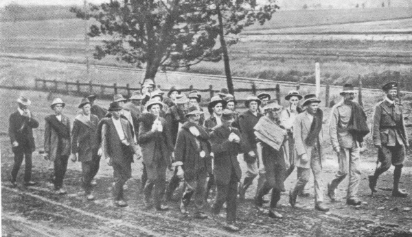
caption = "Cooee marchers" of 1915
lga = Shire of Gilgandra
postcode = 2827
pop = 2,718 (2001 census)
est = 1888
elevation= 282
maxtemp = 24.7
mintemp = 9.9
rainfall = 557.2
dist1 = 460 | location1 = Sydney
dist2 = 66 | location2 = Dubbo
stategov = Barwon
fedgov = Gwydir Gilgandra, a town and Local Government Area (seeGilgandra Shire Council ) in the Central West region ofNew South Wales ,Australia . It is located on the junction of theNewell Highway ,Oxley Highway andCastlereagh Highway and can be reached in about six hours by car fromSydney . It lies on theCastlereagh River . Like Coonabarabran, Gilgandra can be considered to be a gateway to theWarrumbungles National Park .The town was proclaimed in 1888 and the first town blocks were sold in 1889. The area had been previously settled and Gilgandra’s first Post Office was established in 1867 and in 1881 a local school opened, and the first court hearing in the Gilgandra court house was in 1884. The shire was constituted in 1906.
During
World War I , a recruitment march to Sydney began in Gilgandra. The march was known as the 'Cooee March', after the distinct call of "cooee " they shouted at each town along their journey to attract recruits. Twenty-six men left Gilgandra on 10 October 1915. They were feted at each town on the route and recruitment meetings were held. By the time they reached Sydney just over one month later on 12 November, the numbers had swelled to 263 recruits. [ cite web
publisher = Gilgandra and District
title=The Coo-ee March
url = http://www.gilgandra.nsw.gov.au/cooee.htm
accessdate = 2006-11-10 ] [ cite web
publisher = Peoples Voice
title=Gilgandra
url = http://www.peoplesvoice.gov.au/stories/nsw/gilgandra/gilgandra_w_cooee.htm
accessdate = 2006-11-10 ]The geography of Gilgandra is very flat. The soil is composed mostly of sand, making it very porous and difficult to grow certain plants. The weather is hot and dry, reaching 40°C for consecutive days during summer.
Gilgandra has 3 schools; Gilgandra High School, St. Joseph's School and Gilgandra Public School.
References
*Gazetteer of Australia|name=Gilgandra|id=51910
External links
*cite web
author=
year=2004
url=http://www.gilgandra.nsw.gov.au/history.htm
title=Gilgandra " District History
format=
work=
publisher=Gilgandra Shire Council (www.gilgandra.nsw.gov.au)
accessdate=2006-02-27
accessyear=
Wikimedia Foundation. 2010.